| The Variable Ocean: The Legend of Tenterden Church and the Goodwin Sands |
|---|
| |
|---|
The Legend |
|---|
| The Lost Island of the Goodwin Sands ▲ |
|---|
|
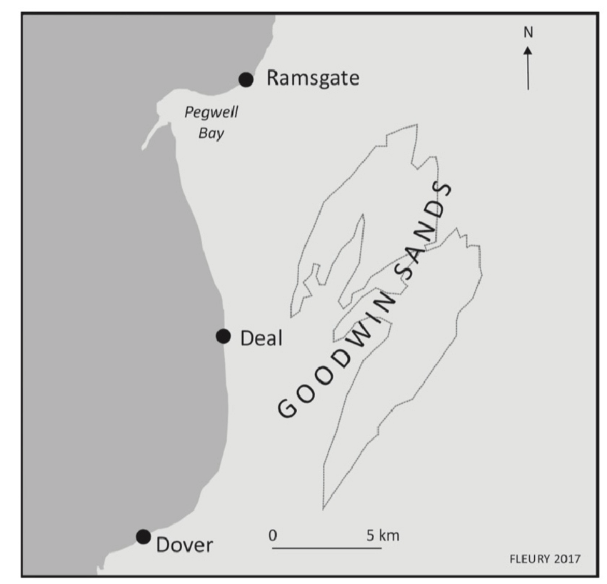
Off the east Kent coast, roughly ten miles from Deal, lies one of the most dangerous stretches of water in the English Channel. The Goodwin Sands — a shifting, semi-submerged bank of sand some ten miles long — have wrecked thousands of ships across the centuries and given rise to one of Kent's most persistent legends: that a fertile island once stood here, lost to the sea in a single catastrophic storm.
Most historians have treated this as folklore. This page argues it is history — and that the island's story can be traced across two thousand years of evidence, from a Roman geographer's coordinates to a Saxon place name, from an earl's estate to a monastery's neglect, and from a medieval storm to the sea-level model that explains precisely why the island survived as long as it did and failed when it did.
The evidence falls into four independent threads, each pointing at the same conclusion.
The first is cartographic. Around 150 AD, the Alexandrian geographer Claudius Ptolemy recorded two islands off the Kent coast. The first was Toliapis — the Isle of Thanet. The second, placed one full longitudinal degree to the east, out into the open waters of the Dover Strait, he called Counus. Ptolemy did not invent place names. He compiled them from Roman naval records and the reports of pilots who knew these waters. Counus was a real, named, navigable island — substantial enough to be an unavoidable landmark for the ships of the Classis Britannica.
The second thread is linguistic. When Saxon settlers arrived in southeast England they named islands with the suffix -ēg, meaning a water-surrounded place — the same element found in Pevensey, Thorney, and Northeye. The first element they gave this island was lōm: Old English for loam, clay, muddy earth. Lōm-ēg — the clay island — became Lomea in the Latin of medieval clerks. The name is a precise landscape description: a flat, low-lying clay platform in the tidal Channel, exactly consistent with the geology of the Dover Strait shelf.
The third thread is historical. Before 1066, these flat Channel lands were the estate of Earl Godwin, father of King Harold. They were defended from the sea by a maintained wall — already, by the late Saxon period, the island required active engineering to survive. After Hastings, the estate passed to St Augustine's Abbey at Canterbury. It was the Abbey's neglect of those sea walls, in November 1099, that the old legend blames for the island's destruction. A great storm drove the tide over the undefended walls, and the clay lands drowned.
The fourth thread is geophysical. The Cumulative Thermal Lag Model developed on this site shows that the sea baseline in the Roman period stood at approximately +2.11 metres above the 19th century datum — high enough that the greater water depth actually stabilised the clay platform by acting as a hydraulic clamp on the unconsolidated sediments below. As the medieval period progressed and the baseline climbed toward its peak of +2.17 metres, that stabilising effect reversed: a higher starting sea level meant any storm surge had far greater destructive reach. The island that the Romans had found solid enough to chart, the Saxons habitable enough to name, and Earl Godwin productive enough to wall and farm, was by 1099 sitting at the precise point of maximum vulnerability. The storm of November that year did not create the Goodwin Sands. It merely delivered the final blow to an island the changing sea had been undermining for centuries.
What follows traces each of these threads in detail.
| | |
|---|
The Source of the Legend ▲ |
|---|
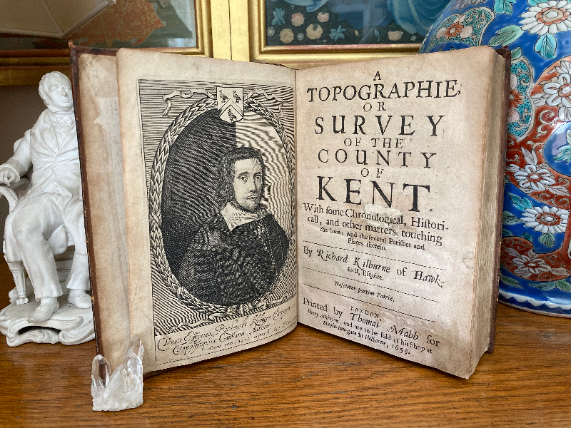
The legend appears to have first been recorded in a book from 1659 by Richard Kilburne of Hawkherst, and was printed by Thomas Mabb for Henry Atkinson, and are to be sold at his shop.
The title of the book is:
A topographie or survey of the county of Kent with some chronological, historicall, and other matters touching the same, and the several parishes and places therein
There is an online version of this text as at 8th June 2024 at 'The University of Mitchigan Library' please click here
| | |
|---|
The Legend ▲ |
|---|
| | |
|---|
The Relevent text from the Book ▲ |
|---|
'(Goodwin Earl of this County, and father of King Harold) was in the time of King Edward the Confessor owner of a great quantity of flat Lands in this County (neer
description Page 263 the Isle of Thane) defended from the sea by a great wall, which lands afterwards (in the year 1099.) was parcell of the possessions of the Abbot of St. Augustine (but reteyned the name of Goodwin, formerly owner thereof) and that Abbot, being then also owner of the Rectory of Tenterden, and having begun the building of this steeple and the time of year for such purpose being much spent, the thoughts, and actions, of him, and his agents were so set upon the finishing of that work, that they neglected the care of watching, and preserving the aforesaid wall, and (3. of November in that year) the sea broke over, and ruined the same, and drowned the aforesaid lands (over∣whelming the same) with a light sand, (there still remaining) and the place thereby obteyned the name of Goodwin Sands, and became (as still it is) dreadfull, and dangerous to Navigators, and thus (accidentially) this Tenterden steeple is said to be the cause of Goodwin sands.'
| | |
|---|
The Name of the Island — From Counus to Lomea to Goodwin ▲ |
|---|
|
The lost island has carried three distinct names across two thousand years, and each name tells us something about the people who used it and the landscape they saw.
Counus — the Roman record (~150 AD)
The name Counus is almost certainly a Brittonic or pre-Roman coastal place name, reaching Ptolemy via Roman naval intermediaries. Its precise meaning is not recoverable with confidence. What matters is its location: Ptolemy places it exactly where the geological and historical evidence independently locates the lost island. The Saxon name Lōm-ēg — the clay island — then describes what people saw when they got there.
Ptolemy did not invent place names. He compiled them from Roman naval records, merchant reports, and the accounts of local pilots who knew these waters. Counus was therefore a name already in use, almost certainly of Brittonic origin, transcribed into Greek script by Alexandrian scholars who had never seen the Kent coast themselves. What matters is the location: a substantial, named, navigable island east of Thanet, recorded at the height of the Roman Warm Period when the sea baseline was running at approximately +2.11 metres above the 19th century datum — high enough that the shallow chalk and clay platform of the Dover Strait shelf would have supported a genuine, stable, above-water landmass.
Lomea — the Saxon name (c.450–1000 AD)
When Anglo-Saxon settlers began naming the landscape of southeast England, they used the suffix -ēg (also written -ea, -eye) to denote a genuine water-surrounded island. This is the same element found in Pevensey, Rickney, Northeye, Thorney, and dozens of other coastal sites that, as shown elsewhere on this site, were true islands in the elevated seas of the early medieval period.
The first element, lōm, is straightforward Old English: it means loam, clay, or muddy earth. Lōm-ēg therefore translates directly as "the clay island" — an entirely accurate description of a low-lying clay and silt platform sitting in the tidal waters of the Channel.
In the hands of Latin-writing clerics, Lōm-ēg would naturally become Lomea — the standard Latinisation of a Saxon -ēg place name, exactly as Pefen-ēg became Pevensey/Pevenesel and similar forms in Domesday.
The name therefore carries a precise landscape memory: this was not a rocky outcrop or a sandy bar, but a flat clay island — exactly the kind of low, compacted estuarine platform that the geology of the southern North Sea shelf produces, and exactly the kind of feature that could support agriculture, grazing, and habitation while remaining acutely vulnerable to storm surge.
Goodwin — the Norman erasure (post-1066)
The final name shift is characteristic of the Norman period. Earl Godwin — father of King Harold — held these flat lands near Thanet before 1066. After Hastings, his estates were redistributed, and the island's ownership passed to St Augustine's Abbey by 1099. The Normans, who did not share the Saxon habit of landscape-descriptive naming, remembered the feature not by what it was but by who had owned it. Godwin's land became Goodwin Sands — a personal name replacing a geographical description. The clay island lost its biography and became a hazard on a chart.
| | |
|---|
The founding of Tenterden ▲ |
|---|
The settlements with the snippet suffix 'den' in their name derive from den-bera - a forest swine pasture, most were settled after Domesday, by people from Kent.
Tenterden is one of those villages not recorded in Domesday so was settled later than 1086AD and was probably settled by displaced Saxons from Kent who were trying to escape the Norman persecution.
The Tenter snippet is probably derived from Tenetwara meaning 'the people of Thanet, however there is another possibility that it derives from tender - tinder for fire lighting because the town was settled in Anglo Saxon Chronicles - 892AD - The Great Oak Forest of Andredsweald
| The Eclesiastical details ▲ |
|---|
There are a considerable number of settlements in the Forest area where the stone churches were started in the 12th century, Tenterden being one of these with its religious health being supported by the Abbot of St. Augustine(Thanet).
Abbots of St Augustines from Wikipedia:
Wido (1087–1099) - he was probably a Saxon with the Normans taking over after Wido
Hugh I of Fleury (d. 26 March 1124), a Norman
Hugh II of Trottiscliffe (1125 – 25 June 1151), a monk of Rochester, election confirmed by cardinal-legate John of Crema
Sylvester (1152–1161), prior, went to Rome to have his election confirmed by the pope, was later excommunicated and deposed by the archbishop, but restored before his death
Clarembald (1163–1173/76), a layman appointed by the king, deposed
Roger (1176 – 20 October 1212), went to Tusculum to be consecrated by the pope
Alexander le Pargiter (1212 – 4 October 1220), went to Rome to be consecrated by the pope
The reference to 1099AD in the original text appears to refer to the transition between the Saxon Abbot 'Wido' and a Norman Abbot 'Hugh I of Fleury'.
The first recorded rector(better paid vicar) of St Mildreds in Tenterden was Hugo Norman from 1180AD until 1240AD, the north arcade of the chancel was probably built in the 1100's so it is likely Hugo was responsible for overviewing the stone construction.
| The fire at St Augustine ▲ |
|---|
From Wikipedia
There was further rebuilding as a result of the great fire in 1168. The fire's destruction accounts for the paucity of historical records for the preceding period.
Although the fire was at St Augustine's in Canterbury, it was probably the records center for all the Kent monasteries, and hence any records of an island were lost in 1168AD.
| The Abbot of St Augustine ▲ |
|---|
English Heritage quotes:
'In 597 St Augustine landed on the shores of the Anglo-Saxon kingdom of Kent at Thanet. He was on a mission from Pope Gregory the Great to convert the pagan Anglo-Saxons to Christianity. Christianity had first been introduced to Britain by the Romans, but survived only in the west after the invasions of pagan peoples from northern Europe in the 5th century.'
'Its prestige was also enhanced by the translation (moving) of the relics of the 8th-century St Mildred from Minster-in-Thanet to St Augustine’s. Mildred was the great-great-granddaughter of King Æthelberht, and the translation affirmed the historical importance of the abbey and its connections with Kentish royalty.'
| The Goodwin Sands ▲ |
|---|
The Goodwin sands are an area to the east of Kent that are close to high tide level and are in the majority a sandy area that has caused numerous ships to be lost when they have run aground.
It is possible that Earl Godwin controlled this island off the Kent coast prior to 1066AD, the ownership of which was transferred to St Augustine's Monastery (Thanet) when the Abbey control was moved from Saxon to Norman in 1099AD and the monastery gained additional lands in Kent.
| 
| | |
|---|
Possible Serious Weather Events around this period ▲ |
|---|
The following weather reports are from Weather Web
973
'Thames flood in London.'
29th September 1014
'"St. Michael's day Flood"; Possible major flood due storm-surge (or some have "tsunami") occurred on 'St. Michael's Day, which is September 29th (OS) in the western / Christian calendar. (Note that Dutch chronicles have this as September 28th). Great damage to coastal communities along the English south coast & given the impact on the eastern side of the southern North Sea, surely had a significant effe't on the English side of that water
11th November 1099
'A tidal flood affected the R. Thames estuary & adjacent areas of north Kent; it is not known whether London was affected, but according to legend, this inundation was responsible for the formation of the Goodwin Sands. The flooding also affected the Dutch coastal areas, so 'tidal' is problematic: I would suspect a wind-driven storm-surge which coincided with a high tide (?spring / exceptional?), and possible excessive autumnal land-water. "Thousands" of deaths reported in areas affected. (I would have thought that if London had been seriously affected, some chronicle of it would have survived?: The 11th century saw a high number of disastrous floods along the English east coast.)'
10th August 1103
'"Great storm on St. Lawrence's Day which did much harm." I believe this Day is celebrated in the Catholic church (and therefore generally at this time) on the 10th August (OS). One site says the storm occurred on the morning of this day - and did more damage than anyone could remember.'
| | |
|---|
Geophysical Analysis: The Mechanics of the 1099 AD Structural Failure ▲ |
|---|
|
The core mystery of the Goodwin Sands has long split historians and geologists. Local tradition and early chroniclers (like Kilburne) insist a low-lying, protected clay estate vanished nearly overnight, while modern marine geologists often argue that a stable, deep-set silt island cannot simply dissolve into sand without thousands of years of steady erosion. However, when we evaluate the 11th November 1099 AD cataclysm through our Cumulative Thermal Lag Model, the historical text and planetary mechanics align perfectly.
According to our model's timeline, the late 11th century sat directly at the absolute apex of the Medieval Warm Period sea levels, with global baselines running at an elevated +1.81 to +2.00 meters relative to the 19th century. During this multi-century peak, the immense weight of an overfilled English Channel acted as a powerful hydraulic clamp. This immense weight compressed the shallow Dover Strait shelf, holding massive accumulations of unlithified alluvial blue clay and estuarine silt tightly against the underlying Upper Chalk platform—structurally stabilizing the low-lying island known as Lomea.
However, by 1099 AD, the climate was experiencing its first sharp, sudden transition toward the cold cycle that would become the Little Ice Age. This rapid turnaround introduced two devastating, simultaneous forces that doomed Earl Godwin's former estate:
- The Hydrostatic Unloading Trigger:The island's vulnerability in 1099 arose from two converging pressures. The medieval sea baseline, running approximately 1.90 metres above the 19th century datum, meant that any storm surge began from a far higher starting point than the island's defences were originally built to withstand. Simultaneously, the early onset of the rate-of-change transition — the first signals of the climate shift that would eventually become the Little Ice Age — began altering basal pore pressure within the sediment layers, reducing the long-term compaction that had stabilised the substrate through the Roman period. The island was not killed by a falling sea or a rising one alone, but by the combination of elevated surge risk and substrate instability at the moment the Abbey's maintenance failed.
- The Weaponized Storm Surge: On 11th November 1099, a severe atmospheric depression tore across the North Sea, pushing an exceptional, wind-driven storm surge through the Dover Strait. Because the base sea level was already structurally high from past cumulative thermal heat, this surge overtopped the island’s defensive sea walls with sufficient force to overtop the defensive walls.
Spontaneous Sedimentary Liquefaction
The combination of these two forces did not merely erode the island; it triggered a massive, localized event known as spontaneous sedimentary liquefaction. As the violent storm waves repeatedly hammered the island, the sudden shift in internal pore pressure—caused by the rapid regional unloading of sea weight—forced water up between the loose clay and silt grains. Instantly, the solid soil lost its structural shear strength and began behaving exactly like a fluid.
Earl Godwin's "flat Lands" literally collapsed sideways and liquefied directly into the racing tidal currents of the Channel. Over the subsequent decades, the relentless anti-clockwise mechanics of the Dover Strait tides ground the dissolved clay away, leaving behind only the heavy, shifting, 10-mile mass of fine sediment and aggregate sand we know today as the treacherous Goodwin Sands.
| | |
|---|
The Ultimate Cartographic Proof: Ptolemy ▲ |
|---|
|
For centuries, mainstream geologists have dismissed the medieval legend of the lost island of Lomea (the Goodwin Sands) as a myth, claiming that if a massive, 10-mile island had existed out in the Straits of Dover, the highly literate Roman Empire would have explicitly mapped it. The data shows they did exactly that.
In his monumental Geographia (c. 150 AD), the Alexandrian geographer Claudius Ptolemy cataloged the coordinates of the British coast. Off the mouth of the Thames Estuary, adjacent to the Trinovantes and Cantium regions, he explicitly logged two distinct islands:
- Toliapis (Isle of Thanet): Located at Longitude 23° 00' / Latitude 54° 20'
- Counus (The Lost Island of Lomea): Located at Longitude 24° 00' / Latitude 54° 30'
The antiquarian William Camden, writing in his Britannia (1607), identified Ptolemy's Counus with Canvey Island in Essex, noting phonetic similarities between Counus and the recorded Saxon forms Counsey and Canf, and observing that Canvey's low, marshy, flood-prone character matched Ptolemy's description of a coastal island. Camden's geographical intuition was sound — but his identification does not survive coordinate analysis. Ptolemy places Counus one full longitudinal degree east of Toliapis (Thanet). Canvey Island lies west-southwest of Thanet, inside the Thames estuary — in precisely the wrong direction. Camden was identifying the right type of island in the wrong location. Ptolemy's grid points unambiguously east of Thanet, into the open waters of the Dover Strait.
The Compaction Reality
This cartographic anchor fits our geophysical model perfectly. In 150 AD, during the height of the Roman Warm Period, our model shows the sea baseline holding at a massive +2.11 meters. Under our Phase 1 Accumulation Rule, this deep water column acted as a powerful hydraulic clamp over the Dover Strait. For centuries, the astronomical silt output from the Thames and River Rother was trapped and heavily compacted onto the flat Upper Chalk platform.
To the captains of the Roman fleet (Classis Britannica), this feature was not a hazardous, shifting underwater sandbank like the modern Goodwins, but a highly visible, stabilized, sub-aerial clay island held together by dense salt-marsh vegetation. Ptolemy recorded it because it was an unavoidable, permanent navigational landmark for ships entering the Kentish channels—proving the island was an absolute physical reality a millennium before its 1099 AD liquefaction failure.
| | |
|---|
Tenterden Church Tower ▲ |
|---|
From the Tenterden website
'This, the most interesting building in Tenterden is dedicated to St Mildred and has a lofty tower that can be seen for many miles across the Kentish Weald. The dedication is not a very common one. St Mildred was a very pious and revered lady who became Abbess of the Abbey at Minster in Kent. Buried originally in her beloved abbey her relics were later transferred to a shrine at Canterbury Cathedral.'
From Wikipedia
St. Mildred's Church is an Anglican church located in Tenterden in the borough of Ashford in Kent, England.
'The church dates from about the 12th century and is Grade I heritage listed.[1] The main tower of the church is 39.6 metres (130 feet) high and was constructed in 1461. It is dedicated to a prominent Anglo-Saxon saint, Saint Mildred—a 7th-century princess who served as the abbess of the nunnery at Minister-in-Thanet. '
The church tower was not started until the height of Tenterden's influence in the Cinque Ports.
| | |
|---|
The Island ▲ |
|---|
|
The biography of this island is inseparable from the behaviour of the sea around it. The Cumulative Thermal Lag Model provides a framework for understanding not just that the island existed, but why it survived as long as it did and why it failed when it did.
200 AD — the island at its most stable
At the height of the Roman Warm Period, the model places the sea baseline at +2.11 metres. Counterintuitively, a higher baseline meant a more stable island. The greater depth of water across the Dover Strait shelf acted as a hydraulic clamp, compressing the clay and silt of the island's substrate and holding the unconsolidated sediments tightly against the underlying chalk platform. To the captains of the Classis Britannica, Counus was a permanent navigational feature, reliable enough to warrant inclusion in Ptolemy's geographical record.
450–600 AD — the island under pressure
As the Roman Warm Period gave way to the colder centuries following 400 AD, the sea baseline began a slow retreat. The island remained above water — the Saxon settlers named it — but the gradual reduction in hydrostatic pressure on the shelf began slowly destabilising the substrate. The island was still habitable, still farmable, still an identifiable estate. But the margin was narrowing.
Pre-1066 — Godwin's estate
Earl Godwin's ownership of these flat Channel lands is recorded in the 1659 account of Richard Kilburne, who describes them as lying near the Isle of Thanet and defended from the sea by a great wall. The existence of a sea wall is itself significant: by the late Saxon period, active engineering was required to hold back the tide. The island was no longer self-sustaining against the sea — it needed maintenance.
1066–1099 — the critical transition
After Harold's defeat at Hastings, Godwin's lands passed to St Augustine's Abbey. The Variable Ocean model shows the medieval sea baseline holding at approximately +1.90 metres in the late 11th century, with the long-term trajectory continuing upward toward its medieval peak. As the baseline rose, the stabilising hydraulic clamp that had protected the island during the Roman period was replaced by a new threat: a higher sea baseline meant that any storm surge had a far greater starting height from which to overtop the defensive walls.
11th November 1099 — the end
The storm recorded on this date drove a tidal surge through the Dover Strait at a moment of maximum vulnerability. The Abbey, according to Kilburne's account, had neglected the maintenance of the sea walls — the rebuilding of Tenterden's church absorbing attention and resources that should have gone to the defences. Whether or not that specific detail is accurate, the outcome is not in doubt. The sea walls failed. The flat clay lands flooded. The estuarine silt and Channel sand that followed erased the agricultural surface and left the shifting, treacherous bank that has wrecked ships ever since.
1168 — the documentary silence explained
The great fire at St Augustine's Abbey in Canterbury in 1168 destroyed the local monastic records. Any surviving documentation of the island — its extent, its inhabitants, its revenues, its history under the Abbey — would have been held there. The silence in the post-1099 record is not evidence that the island never existed: it is the expected consequence of losing the only institution that would have preserved those records.
| | |
|---|
Is there any truth in this Legend ▲ |
|---|
|
The legend as recorded by Kilburne in 1659 contains one clear anachronism: it attributes the neglect of the sea walls to an Abbot preoccupied with building Tenterden's steeple. The great tower of St Mildred's was not begun until 1461 — three and a half centuries after 1099. Kilburne, writing 560 years after the event from secondhand sources, appears to have attached the legend to the most prominent and visible feature of the church as it stood in his own day.
This does not invalidate the legend. It explains how folk memory works. The underlying account — an Abbot of St Augustine's neglecting sea wall maintenance in 1099, with catastrophic consequences — is entirely consistent with the documented transition between Abbot Wido (Saxon, died 1099) and the incoming Norman administration under Hugh I of Fleury.
Institutional disruption at a moment of ownership transfer is a perfectly plausible reason for maintenance to lapse. The steeple detail is the legendary accretion; the neglected wall is the historical core.
The Ptolemy coordinates, the Lōm-ēg etymology, the Kilburne account, the 1099 storm record, the 1168 fire, and the geophysical model all independently point at the same conclusion: a real island existed here, was known to the Romans, named by the Saxons, farmed by Earl Godwin, passed to St Augustine's Abbey, and lost in the storm surge of November 1099. The legend is not folklore dressed as history. It is history that survived as legend because the documentary record burned in 1168.
| | |
|---|
Links to other Variable Ocean Documents ▲ |
|---|
|
The pages below show links to documents that reference pages concerning The Variable Ocean.
These pages discuss the apparent historical Sea Level changes that have been found across the UK, their implications and the creation of a theory of Sea Level changes that incorporates these observations, this in turn has developed into a geological framework that explains earthquakes, subduction zones and supervolcanoes.
For the individual pages please click on the links, new documents will be auto populated as and when these
are written.
| |
|
|
;)


