| The Variable Ocean: Tidebrook near Wadhurst could it have been tidal ?? |
|---|
My current theory on Saxon Place Names
In 2000 I was looking at the place names around Hastings, which all appear to be Saxon, with a very few exceptions, and wondered what they meant.
My research lead me to conclude that this area was settled between the take over of Kent by Henghest and Horsa, and the take over of the South Downs area by Aelle, so around 465AD, and was settled by the Saxons.
If you are interested in this invasion please take a look at The sequence of the Saxon Invasion
As a lot of villages have similar snippets in their name and I wondered if each of these meant something, and that this in turn might mean that the settlement names described the use or surroundings of a place.
I am not a historian, so until 2026 I had not come across the Gelling-Cole Hypothesis, but this seems to fit well with my stuff. I have also in 2026 found an academic document written by Dr Robert Higgs from the 'The Journal of Coastal Research' which discusses sea levels in early Saxon times, this also fits my research.
So what could these snippets mean ??
My conclusions may seem surprising but please read Places containing the snippet æg meaning island before reading any other snippet pages as this explains the reason for the '4.5 metre line' described in other snippets.
| | |
|---|
Tidebrook ▲ |
|---|
It is unlikely that you have heard of Tidebrook unless you live near Wadhurst or Mayfield in East Sussex.
Tidebrook is a Saxon name that is made up of Tide derived from tyd - time - meaning regular and brook derived from broc - a brook or stream
I have always been fascinated by the name of this location as it implies that the River Rother was tidal all the way up to this location in early Saxon Times.
| 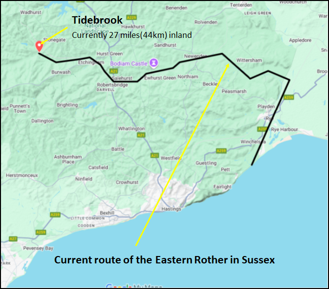
This is a Google My Maps showing the location of Tidebrook, which is a stream that rises near Mark Cross in East Sussex, so how could it be possible for the tides to reach here ?
The point where the Tidebrook reaches the Rother is about 27 miles inland from the current mouth of the Eastern Rother which is at Rye. The hamlet of Tidebrook is a further 3 miles (5Km) further upstream, and its source is a further 2.2 miles (3.6Km) upstream.
It is very unlikely that the stream could have been tidal up to the Hamlet of Tidebrook, so we will try to analyse whether it's possible for the tide to carry on up the Rother to the place where the Tidebrook joins the Rother which currently lies about 29 metres higher than the OD (Ordnance Datum - Average tide level).
| Navigation in the River Rother ▲ |
|---|
The river Rother is currently only tidal to the lock at Scots Float Sluice, also known as Star Lock just north of Rye, this was probably built in the late 1600s as there are records of repairs being carried out in 1723.
However there were two Acts of Parliament passed in 1826 and 1830 that refer to this area, they are known as the Rother Levels Acts.
These acts primarily focused on ensuring navigation on the River Rother between Scots Float and Bodiam Bridge, specifically requiring a minimum of 5 feet of headroom under bridges. The Acts also dealt with managing the low-lying land (Rother Levels) through which the river flows, likely for drainage and agricultural purposes.
| Navigation to Bodiam ▲ |
|---|
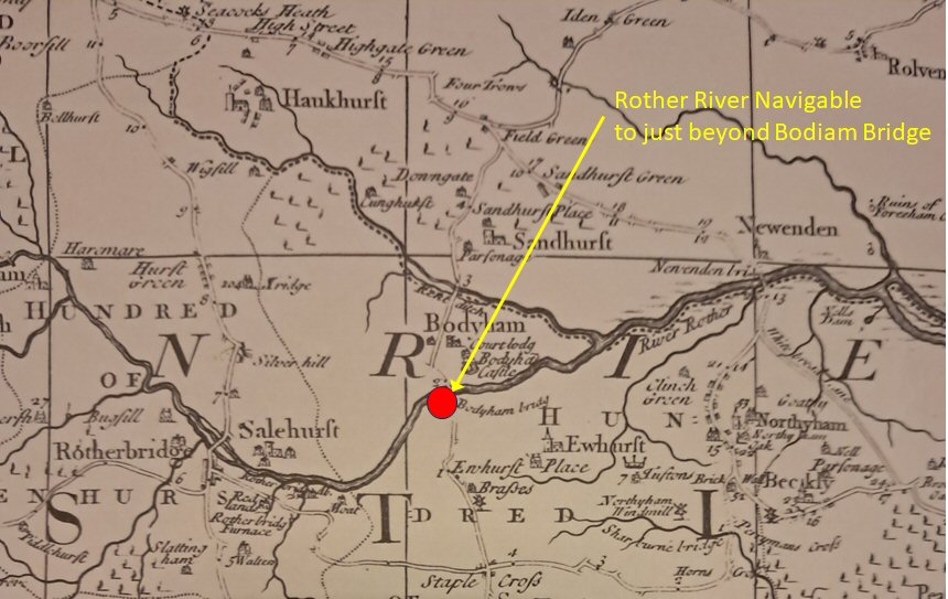
The map above was produced by Richard Budgen, and drawn in 1724 showing the navigation to Bodiam.
In this context it would imply that the Rother was tidal to at least Bodiam, and allowed for seagoing vessels with a draft of about 2 metres all times of the day. the Rother at Bodiam is currently at about 5 metres O.D.
The Robertsbridge Furnace at this time was producing iron bar and cannon balls, so these were probably being carried by barge down to the Bodiam or Newenden where they would be transshipped to sea going vessels, however this implies that the Rother at Robertbridge would also have been salt water at high tide times. Robertsbridge is about 8 metres O.D.
Bodiam Castle and navigation to Bodiam in the 1300's.
If the sea reached Bodiam pre 1700's then the Rother would have been able to carry barges on the tides much further inland possibly to Etchingham or Burgham.
| Cannon making in Robertsbridge ▲ |
|---|
Robertsbridge Furnace Timeline & Evidence
Period Activity & Evidence
- 1541-1546 Iron Production: Furnace built by Sir William Sidney to supply a forge. Note: No ordnance cast during Sidney's ownership.
1728 Gun Founding Begins: The first clear reference to "gun cleaning" at the furnace appears.
- 1754-1767 Major Cannon Production: Under lease to John Churchill, a Staffordshire ironmaster. He proposed supplies of 200-400 tons of ordnance.
- (1756-1757) and cast guns for both the Board of Ordnance and the merchant trade.
- 1768-1774 Later Operations: After Churchill, James Bourne supplied guns to the Board of Ordnance.
- 1793 Closure: The furnace closed permanently.
To transport guns from the Furnace to anywhere except via the river Rother would have been very difficult, as the area is mostly clay and cannons are very heavy so would rip up the roads, and no reports of this are found. So the assumption is that the cannons were taken by barge(probably on the tides to Bodiam to be shipped out.
This in turn implies that the Rother was wider and deeper than the present day.
| Other Forges and Furnaces nearby ▲ |
|---|
The area is rich in iron, and there were two other locations that could have used the Rother as transport.
These were:
Etchingham Forge
Found in the Rother valley between Etchingham and Ticehurst
Possibly in use from 1521 until it was closed down in 1740.
Darwell (Darvel or Darfold) Furnace and Forge
A cannon manufacturing plant found on the Darwell stream that feeds into the Rother valley near Robertsbridge
Possibly in use from 1539 until it was closed down in 1774.
Please note: the above data originates from the Wealden Iron Research Group
| The Romans in this area ▲ |
|---|
Recent excavations at Bodiam by the Robertsbridge Archaeological Society have unearthed a Roman Port on the South Bank of the Rother near the current level crossing for the Kent & East Sussex Steam Railway, with a causeway from the North Bank coming over to the Port, and most likely a moveable bridge for the final stretch over the river to the South bank.
This port was most likely a Sea Port where shallower depth barges headed west towards Etchingham and Stonegate, where one of the larger Roman iron working plants was located in an area called Bardown. This translates from the Saxon as either the bear or boar fort, probably originated by the Celts.
The River Rother's height above Ordnance Datum (OD) is 2.225 meters at Bodiam.
Tidebrook is only about 1.5 miles(2.4 Km) from the Bardown ironworks.
| Conclusion ▲ |
|---|
If all the factors are taken into account, then there is a possibility that Tidebrook was actually Tidal.
| Scientific papers that support this concept ▲ |
|---|
A recent scientific paper published in 2026 has provided compelling geological evidence for a major sea-level event in the 5th century, directly corroborating the theory developed on this site from place-name and topographic analysis. This new evidence transforms our understanding from a plausible hypothesis into a well-supported model of rapid coastal change during the Early Anglo-Saxon period.
The Article:
English Coastal Archaeological Evidence of a Fifth-Century (Dark Ages) 4-Meter Sea-Level Rise in 70 Years, Portending a Similar Rise Imminently
Please click on the following link to see the paper from the Journal of Coastal Research if this doesn't work, please copy and paste the following into a browser [ https://jcr.kglmeridian.com/view/journals/coas/42/1/article-p165.xml ] then click the 'Download pdf' button.
Written by Dr Roger Higgs and published online January 2026 in the Journal of Coastal Research.
| Research Findings ▲ |
|---|
1. Introduction: New Scientific Corroboration
A scientific paper above has provided compelling geological evidence for a major sea-level event in the 5th century, directly corroborating the theory developed on this site from place-name and topographic analysis. This new evidence transforms our understanding from a plausible hypothesis into a well-supported model of rapid coastal change during the Early Anglo-Saxon period.
2. Summary of the Key Scientific Finding
A study of coastal archaeological sites across England, including the Roman fort at Pevensey, demonstrates that a rapid relative sea-level rise of approximately 4 meters occurred within roughly 70 years, spanning the period ~430-500 AD (the early "Dark Ages"). This was a major marine transgression that dramatically reshaped the coastline.
3. Connecting the Evidence: Place-Names Meet Geology
The convergence of evidence is striking:
- Geological Proof: At Pevensey Castle, excavations found early-5th-century tidal mud within the defensive ditch at a level over 2 meters higher than the fort's original foundations. This indicates the high-tide water level rose significantly after the fort was built, undermining its walls by the mid-to-late 5th century.
- Historical Geography Explained: This ~4-meter rise is precisely the scale required to transform the settlements with "-ey" (from Old English æg, meaning island) on the Pevensey Levels into true tidal islands. The scientific data confirms the landscape model derived from place-names and flood maps.
4. Broader Historical Implications
This rapid environmental change likely had profound historical consequences. As noted in the research, it may help explain the mass migration of Angles and Saxons to southeastern Britain in the 5th century. Their homelands on the North Sea coastal plains may have become increasingly inundated and uninhabitable, "squeezed" between the encroaching sea and other population pressures.
5. Modern Context and Conclusion
The combination of historical geography (place-names and topography) and modern geological science now presents a coherent and evidence-based picture of a pivotal environmental event at the dawn of English history.
| Links to other Variable Ocean Documents ▲ |
|---|
|
The pages below show links to documents that reference pages concerning The Variable Ocean.
These pages discuss the apparent historical Sea Level changes that have been found across the UK, their implications and the creation of a theory of Sea Level changes that incorporates these observations, this in turn has developed into a geological framework that explains earthquakes, subduction zones and supervolcanoes.
For the individual pages please click on the links, new documents will be auto populated as and when these
are written.
| |
|
|
;)


