| Saxon Place Names (Hurst) |
|---|
My current theory on Saxon Place Names
In 2000 I was looking at the place names around Hastings, which all appear to be Saxon, with a very few exceptions, and wondered what they meant.
My research lead me to conclude that this area was settled between the take over of Kent by Henghest and Horsa, and the take over of the South Downs area by Aelle, so around 465AD, and was settled by the Saxons.
If you are interested in this invasion please take a look at The sequence of the Saxon Invasion
As a lot of villages have similar snippets in their name and I wondered if each of these meant something, and that this in turn might mean that the settlement names described the use or surroundings of a place.
I am not a historian, so until 2026 I had not come across the Gelling-Cole Hypothesis, but this seems to fit well with my stuff. I have also in 2026 found an academic document written by Dr Robert Higgs from the 'The Journal of Coastal Research' which discusses sea levels in early Saxon times, this also fits my research.
So what could these snippets mean ??
My conclusions may seem surprising but please read Places containing the snippet æg meaning island before reading any other snippet pages as this explains the reason for the '4.5 metre line' described in other snippets.
| | |
|---|
Does the Hurst snippet in Saxon village names mean a wood ? ▲ |
|---|
The current etymology(derivation) of the snippet hurst
From Wiktionary:
From Middle English hirste (“wood, grove; hillock; sandbank, sandbar”), from Old English hyrst (“hillock, eminence, height, wood, wooded eminence”), from Proto-West Germanic *hursti; akin to Dutch horst (“thicket; bird's nest”), German Horst (“thicket, nest”).
From Etymonline:
"hillock" (especially a sandy one), also "grove, wooded eminence," from Old English hyrst "hillock, wooded eminence," from Proto-Germanic *hursti- (see horst). Common in place names (such as Amherst).
From localhistories.org:
Hurst meant a wooded hill.
From the 'Oxford Illustrated Dictionary 1981':
Hurst - Hillock; sandbank in the sea or river; wooded eminence; wood;
From the Anglo-Saxon Dictionary online':
Hyrst - a hurst, copse, wood.
From the above different etymologies it would seem that a hurst could be a wood.
| What history do we have for the hursts ▲ |
|---|
There appear to be a lot of settlements with the snippet hurst in my local area, but the only early records for these settlements appear in the old church records. Lets look at some of the hursts in my area which is along the Kent and Sussex Borders. The examples I will be using as a sample run along the old ridgeway from Newenden to Wadhurst and see if there are any references we can use.
These consist of the churches of Sandhurst, Hawkhurst, Ticehurst and Wadhurst.
The history of St Michael's Sandhurst
1175 - First mention of Sandhurst
1220 - First mention of a chapel in Sandhurst
The history of St Lawrence Hawkhurst
It is likely that there has been a church on this site from at least 1100, maybe earlier, when Hawkhurst belonged to the Abbot of Wye, and then of Battle, given to him by William the Conqueror as part of his thank-offering after the Battle of Hastings. The first mention of the building is in a Charter of 1285 and the first Rector whose name we have is Richard de Clyne in 1291.
The history of St Mary's Ticehurst
In the year 1018 King Cnut made a grant to Aelfstan, Archbishop of Canterbury of “a certain little woodland pasture in the famous wood of Andredeswealde which is commonly called Haeselersc…” The name survives today as Hazelhurst Farm in Ticehurst parish.
The Domesday Survey which started in 1086 does not mention Ticehurst, but it refers to “Hasslesse” (again Hazelhurst).
The earliest reference to Ticehurst is in a document of 1180 relating to Combwell Priory and mentions “Adam, Presbyter de Tychenherste. In 1197 the church at Ticehurst is confirmed as coming under Hastings Priory.
The history of St Peter & St Paul Wadhurst
The church dates from the early 12th Century. It is situated in the centre of Wadhurst, just off the main street. Built of sandstone, the tower is from 1100, and its fine shingle spire, recently restored after gale damage, dates from the 14th Century.
From the above records it would seem that hursts are mentioned in the Domesday Book from 1086AD, but not the villages listed, and that these were founded before the 1100's.
| The Domesday book 1086AD ▲ |
|---|
The Domesday Book was created for William the Conqueror to enable him to asses taxes.
Let us now look at the 'hursts' mentioned in the Domesday book for Sussex and Kent to see if this shows any suggestions.
| | |
|---|
A map of all the Hursts mentioned in Domesday ▲ |
|---|
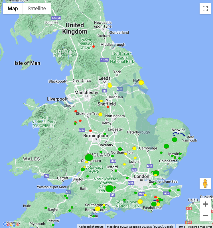
This map is based on Google maps using their API, and shows all the Hurst's mentioned in Domesday, there are very few, this is odd as we observe a large number in this area today. The dot sizes show relative population size, green shows undamaged settlements, yellow damaged, and red destroyed.
The data for this map is derived from the Open Domesday website
This is the first free online copy of Domesday Book. The site was built as a non-profit project by me, Anna Powell-Smith, using data created by Professor J.J.N. Palmer and a team at the University of Hull.
| A map of all the modern Hursts ▲ |
|---|
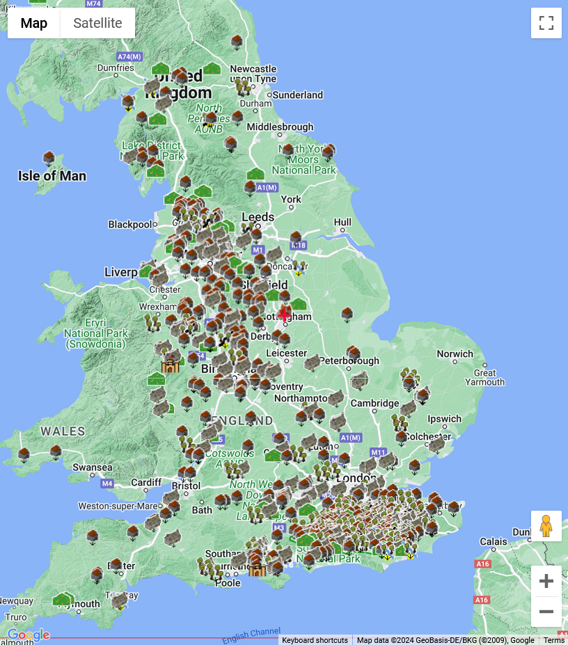
This map is based on Google maps using their API, and shows all the Hursts mentioned in the Ordnance Survey Open Names dataset.
There appear to be two main clusters of hursts, one in the South East, the other in the West Midlands area.
| A map of all the South Eastern Hursts mentioned in Domesday ▲ |
|---|
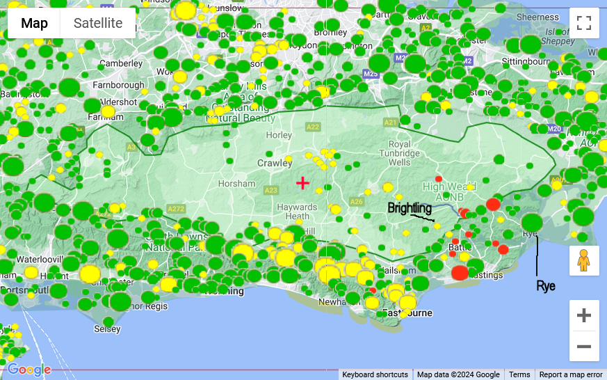
This map is based on Google maps using their API, and shows all the Hurst's mentioned in Domesday, as is obvious there is a large empty area in the Wealden area. The circle size shows the relative settlement sizes, Brightling is described as having a population of 12, and Rye a population of 189. Red circles are destroyed villages, yellow damaged and green unaffected by the invasion.
The data for this map is derived from the Open Domesday website
This is the first free online copy of Domesday Book. The site was built as a non-profit project by me, Anna Powell-Smith, using data created by Professor J.J.N. Palmer and a team at the University of Hull.
| Is there anything this boundary in Domesday could represent ▲ |
|---|
The Anglo Saxon Chronicles 892AD - the Viking large army.
This year went the large army, that we before spoke about, came from a kingdom in the east, westward to Bologne; and there were shipped; so that they transported themselves over at one time with their horses withal. And they came up with two hundred and fifty ships into the mouth of the Limne, which is in East-Kent, at the east end of the vast wood that we call Andred.
This wood is in length, east and west, one hundred and twenty miles, or longer, and thirty miles broad. The river that we before spoke about comes out of the weald.
On this river they towed up their ships as far as the weald(wood). Four miles from the mouth of the river they destroyed a fort within the fen(possibly near Burmarsh - Burh Maersc the marsh fort), whereon sat a few churls, and which was hastily wrought. Soon after this came Hasten up with eighty ships into the mouth of the Thames, and wrought him there a work at Milton. and the other army went to Appledore.
So we have a large forest 120 miles long by 30 miles wide covering the area which is the approximate size for the boundary we have drawn.
| | |
|---|
A map of all the modern Hursts in the South East ▲ |
|---|
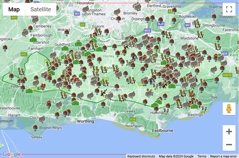
This map shows the modern hursts in the South East of Britain, and as you can see the majority of hursts line inside the green boundary.
| Timescales for the Hursts ▲ |
|---|
|
The pattern from the maps and church records requires careful interpretation. The hurst settlements that appear in Domesday in 1086AD are not newly founded — they are early Saxon clearings, established when the first settlers pushed into the forest edge from around 460AD onwards. These are old communities, named for the ground their founders cleared from the trees.
What Domesday shows is that in 1086AD these hursts still sat within or at the edge of a largely intact forest. The empty area at the centre of the Wealden map is not unsettled land — it is the surviving forest interior, too dense and too useful as standing timber to have been cleared for habitation yet.
The reason so few hursts appear in Domesday relative to the number that exist today is not that they hadn't been founded — it is that the forest had not yet been eroded far enough inward to reach them. The hursts on the Hastings and Pevensey side of the Weald appear earliest because that is where iron production and shipbuilding were most intensive. Six hundred years of continuous felling for charcoal and ship timber, concentrated on the coastal river valleys, progressively consumed the forest between the coast and the early Saxon clearings, eventually exposing those settlements on what had become the new forest edge.
The wave of new hurst place names appearing in records from around 1100 onwards likely reflects this process reaching its later stages — not a new population moving in, but existing settlements becoming visible and recordable as the forest around them thinned and they joined the wider landscape of named communities.
| | |
|---|
Conclusion ▲ |
|---|
|
The snippet hurst originally meant a clearing in a forest — not a wood or copse, but a piece of ground that had been felled and settled within the bounds of the great Forest of Andredsweald. The earliest hursts were made by Saxon settlers pushing into the forest from around 460AD, and they were genuine clearings surrounded on all sides by dense woodland.
What changed over the following six centuries was not the settlements but the forest around them. Continuous felling for iron smelting and shipbuilding, concentrated on the Hastings and Pevensey side of the Weald, progressively eroded the forest inward. The hursts that Domesday records as isolated woodland settlements gradually found themselves no longer deep in the forest but on its shrinking edge, and eventually in open countryside altogether.
By the time later speakers encountered place names like Hawkhurst or Ticehurst, the clearing had long since become a village surrounded by farmland, and the word hurst came to mean the patches of remaining woodland nearby rather than the cleared ground it originally described. The original meaning was quietly reversed — a small linguistic record of a very large environmental change.
| | |
|---|
Further Implications ▲ |
|---|
|
If the early hurst settlements were Saxon clearings from around 460AD, and if the forest around them was being continuously eroded by iron production and shipbuilding over the following centuries, then the forest boundary implied by the Domesday distribution is not the original Saxon-era boundary — it is what remained after six hundred years of industrial felling.
The original forest, before the Romans and Saxons began extracting timber and iron, would have extended considerably further toward the coast. The hursts on the Hastings and Pevensey side were not at the forest edge when they were founded — they were inside it. The forest edge has simply retreated past them over time.
This in turn suggests that the rate of forest clearance can be estimated, at least roughly, from the distance between the early hurst settlements and the coast, and the known period of Roman and Saxon industrial activity in the area. For more on this, see The Great Forest of Andredsweald.
|
|
|
;)


