| The Cinque Ports and Southern England |
|---|
| |
|---|
Introduction |
|---|
I will be trying to show how the Cinque Ports developed from the late Saxon times until modern times.
| The Creation of the Cinque Ports ▲ |
|---|
Originally created by the ports of Dover, Sandwich and Romney during Edward the Confessor's times for mutual protection and trade.(the original charter was probably created out of a need to purchase the loyalty of a group of potentially troublesome ports that were of strategic importance to the control of cross-Channel traffic)
Hastings and Hythe probably joined just after the Norman Conquest to create the original Confederation of Cinque Ports. By AD1190 Rye and Winchelsea who were part of the Hastings contingent had been accepted as 'Ancient Towns'.
As an aside William the Conqueror landed near Hastings however Romney was reported as being destroyed because they killed all the sailors from some of the Norman ships.
This was most likely caused by some of the Norman ships that were overloaded or taking on water, and the area near Romney/Langport was the nearest place to land.
Once Harold had been defeated William went to Romney and then Dover before going to London, this was to ensure that the original three ports were going to be loyal to William and were not going to provide ships to the remaining Saxon Earls to provide sea transport so his troops were cut off.
| | |
|---|
The pre-Conquest roots of the ship-service obligation ▲ |
|---|
|
The formal Cinque Ports confederation, with its charters, its collective obligations, and its extraordinary legal privileges, was a post-Conquest institution. But the ship-service relationship between the crown and the south-east coast ports was not. The evidence from the Anglo-Saxon Chronicles makes clear that the ports were already being called upon to provide vessels and crews for royal purposes in the decades before 1066, and that the crown's ability to do so depended on the political loyalty of those ports — a loyalty that was neither uniform nor guaranteed.
The Burghal Hideage of 914 AD had already established a system of defended coastal settlements with defined obligations to the crown, and Hastings appears in that document as a fortified burh with responsibilities for local defence. The ship-service that would later be formalised in the Cinque Ports charter grew out of the same logic: coastal communities whose livelihoods depended on the sea were the natural source of naval power for an English king, and in exchange for privileges and protection they were expected to provide vessels when called upon. By the reign of Edward the Confessor this relationship was well established in practice even if it had not yet been codified in a single collective charter.
The critical question — and the one that the chronicles of the 1040s and 1050s illuminate most sharply — is which ports could be relied upon, and why. The answer was not simply geographical. It was political, economic, and in the case of the Hastings area, deeply shaped by a Norman ecclesiastical presence that predated the Conquest by half a century.
| | |
|---|
The divided loyalties of the pre-Conquest ports — a closer reading ▲ |
|---|
|
The Anglo-Saxon Chronicles for the period 1046 to 1052 reveal a coastline that was politically fractured in ways that map very closely onto the later structure of the Cinque Ports. Understanding those fractures requires looking at each port not simply as a place on a map but as a community with its own interests, obligations, and connections.
Sandwich was consistently the crown's principal fleet anchorage throughout this period. It appears in the chronicles repeatedly as the assembly point for royal ships, the location where the king waited for his fleet, and the destination to which prizes were brought when loyalty to the crown was demonstrated. Its position at the northern end of the Wantsum channel, sheltered from Channel weather by the shingle bar from Deal, made it the most defensible and manageable fleet base on the east-facing coast. Its consistent support for Edward and the crown almost certainly reflects both this strategic value — the king invested heavily in keeping Sandwich loyal — and the port's relative distance from the Godwin family's personal heartland further west.
Dover had every reason to support Godwin after 1051. The violent affray in which Count Eustace of Boulogne's retinue killed more than twenty Dover townspeople, and the king's subsequent demand that Godwin harry the town as punishment, turned the townspeople firmly against Edward and towards the earl who had refused to carry out the punishment. The fact that Dover, Hythe, Romney, and Folkestone all appear in the 1052 chronicle entries as places where Godwin's returning fleet was able to collect ships, hostages, and provisions is entirely consistent with this: they were Kent ports in the orbit of a Dover that had become a Godwin stronghold by default.
| | |
|---|
Fécamp, Rameslie, and the Norman shaping of the Hastings hinterland ▲ |
|---|
|
In 1017, Queen Emma — the Norman widow of Aethelred II who had married the new king Canute — facilitated the grant of the Manor of Rameslie to the Benedictine Abbey of Fécamp in Normandy. Rameslie encompassed what are now Rye, Old Winchelsea, and the eastern approaches to Hastings, together with five churches and approximately a hundred salt-pans. The abbey administered this estate continuously for the next two and a half centuries, operating through a priory at Rye whose monks were in permanent residence in the landscape between Hastings and Romney.
The practical consequences of this for the Haestingas were profound. The Abbot of Fécamp held rights over fishing tithes, salt production, and shipbuilding across the Rameslie estate. Norman monks collected dues from Saxon fishermen, supervised salt-workers on the foreshore, and administered the churches that served the coastal communities. The men of Hastings and Rye paid their obligations not to an English lord but to a Norman abbey. Over the course of a generation this created a set of economic and institutional relationships between the Hastings maritime community and Normandy that had no parallel in the Kentish ports to the north.
When Edward the Confessor — himself deeply Norman in outlook, surrounded by Norman advisers, and eventually appointing Robert of Jumièges, a Norman with close Fécamp connections, as Archbishop of Canterbury — sought the loyalty of the south coast ports, the Haestingas were already operating within a world in which Norman authority was not foreign but familiar. The distinction between the English crown and Norman interests that appears so stark in the standard narrative of 1066 was, from the perspective of a fisherman paying tithes to Fécamp's Rye priory, not a distinction at all.
This is why Hastings is listed first in the Cinque Ports. Its seniority reflects not merely its size or its shipbuilding capacity, though both were significant given its direct access to the Wealden oak of Andredsweald, but its demonstrated reliability as a crown-supporting port at a moment when the loyalty of the entire south-east coast was genuinely uncertain.
| | |
|---|
Hastings and the Norman Crown: Intelligence, Loyalty, and the Reward of Primacy ▲ |
|---|
|
The composition of Harold's fleet at the Isle of Wight in September 1066 can be inferred from the Anglo-Saxon Chronicle's 1052 entry, which records Earl Godwin collecting ships from Hastings, Romney, Hythe, Folkestone, Dover, Sandwich and Pevensey on his return from exile. The same ports would have furnished ships to Harold's fleet fourteen years later. Among them, Hastings occupied a singular position that had nothing to do with the quality of its harbour or the size of its fleet.
The town had attacked Harold's brother Swein in 1049, had been administered by Fécamp Abbey for fifty years, and had structural economic ties to Normandy through the fish trade and wine imports that the abbey controlled. Its loyalty lay with the Norman royal line, not the Godwins, and that loyalty had been expressed consistently across the preceding decades. Fécamp's administration of the Rameslie estate gave the abbey — and through it, Normandy — a permanent presence on the Hastings waterfront, controlling the economy and the flow of information across the Channel. It would be remarkable if that conduit had not been used.
When Harold stood down his fleet on 8 September 1066 and the ships dispersed toward Pevensey, one Hastings vessel crossing south rather than east would have been unremarkable in the general movement. The crossing from the Isle of Wight to the Normandy coast is some eighty miles — achievable within a day with a fair wind. If such a vessel reached Dives on the 8th or 9th, carrying word that Harold could no longer hold his fleet together, it would explain what has never been satisfactorily accounted for: why William chose that precise moment to move, departing Dives within days of Harold's stand-down despite weeks of prior inaction. Hastings may have been feeding intelligence to Normandy throughout the summer of 1066. The stand-down of the Saxon fleet was simply the last and most important report.
The post-Conquest settlement makes most sense read against this background. William granted Hastings the headship of the Cinque Ports — primacy over the entire English coastal administration, including Sandwich, which held the superior naval infrastructure, the deeper anchorage, and the longer history as the royal fleet base. On purely operational grounds Sandwich should have been head port. That Hastings held the senior position instead, with the extensive privileges, self-governance, and jurisdictional authority that came with it, points to a different kind of calculation. The Cinque Ports charter was not simply administrative convenience following the Conquest. It was a debt repaid in institutional form — Hastings receiving in perpetuity the formal dominance over the coast it had been watching informally for William for half a century.
| | |
|---|
Documentary Evidence - Anglo Saxon Chronicles ▲ |
|---|
The following texts are extracted from the Anglo Saxon Chronicles and refer to the Ports.
1015AD At the same time came King Knute to Sandwich, and went soon all about Kent into Wessex, until he came to the mouth of the Frome; and then plundered in Dorset, and in Wiltshire, and in Somerset. King Ethelred, meanwhile, lay sick at Corsham; and Alderman Edric collected an army there, and Edmund the etheling in the north. When they came together, the alderman designed to betray Edmund the etheling, but he could not; whereupon they separated without an engagement, and sheered off from their enemies. Alderman Edric then seduced forty ships from the king, and submitted to Knute. The West-Saxons also submitted, and gave hostages, and horsed the army. And he continued there until midwinter.
1046AD And in this same year King Edward went out to Sandwich with a great fleet. And Sweyn the earl, son of Godwin the earl, came in to Bosham with seven ships; and he obtained the king's protection, and he was promised that he should be held worthy of everything which he before possessed. Then Harold the earl, his brother, and Beorn the earl contended that he should not be held worthy of any of the things which the king had granted to them: but a protection of four days was appointed him to go to his ships. Then befell it during this, that word came to the king that hostile ships lay westward, and were ravaging. Then went Godwin the earl west about with two of the king's ships; the one commanded Harold the earl, and the other Tosty his brother; and forty-two of the people's ships. Then Harold the earl was removed from the king's ship which Harold the earl before had commanded. Then went they west to Pevensey, and lay there weather-bound. Upon this, after two days, then came Sweyn the earl thither, and spoke with his father, and with Beorn the earl, and begged of Beorn that he would go with him to the king at Sandwich, and help him to the king's friendship: and he granted it. Then went they as if they would go to the king. Then whilst they were riding, then begged Sweyn of him that he would go with him to his ships: saying that his seamen would depart from him unless he should at the soonest come thither. Then went they both where his ships lay. When they came thither, then begged Sweyn the earl of him that he would go with him on ship-board. He strenuously refused, so long as until his seamen seized him, and threw him into the boat, and bound him, and rowed to the ship, and put him there aboard. Then they hoisted up their sails and ran west to Exmouth, and had him with them until they slew him: and they took the body and buried it in a church.
1049AD Then the king and all the army proclaimed Sweyne an outlaw. A little before this the men of Hastings and thereabout fought his two ships with their ships, and slew all the men, and brought the ships to Sandwich to the king. Eight ships had he, ere he betrayed Beorn; afterwards they all forsook him except two; whereupon he went eastward to the land of Baldwin, and sat there all the winter at Bruges, in full security.
1050AD Thither also came Sweyn the earl, who before had gone from this land to Denmark, and who there had ruined himself with the Danes. He came thither with false pretences; saying that he would again be obedient to the king. And Beorn the earl promised him that he would be of assistance to him. Then, after the reconciliation of the emperor and of Baldwin, many of the ships went home, and the king remained behind at Sandwich with a few ships; and Godwin the earl also went with forty-two ships from Sandwich to Pevensey, and Beorn the earl went with him. Then was it made known to the king that Osgood lay at Ulps with thirty-nine ships; and the king then sent after the ships which before had gone home, that he might send after him. And Osgod fetched his wife from Bruges, and they went back again with six ships. And the others landed in Sussex [Essex] at Eadulf-ness, and there did harm, and went again to their ships: and then a strong wind came against them, so that they were all destroyed, except four, whose crews were slain beyond sea. While Godwin the earl and Beorn the earl lay at Pevensey, then came Sweyn the earl, and begged Beorn the earl, with fraud, who was his uncle's son, that he would be his companion to the king at Sandwich, and better his affairs with him.
1051AD And then came Eustace [Earl of Boulogne] from beyond sea soon after the bishop, and went to the king, and spoke with him that which he then would, and went then homeward. When he came to Canterbury, east, then took he refreshment there, and his men, and went to Dover. When he was some mile or more, on this side of Dover, then he put on his breast-plate, and so did all his companions, and went to Dover. When they came thither, then would they lodge themselves where they chose. Then came one of his men, and would abide in the house of a householder against his will, and wounded the householder; and the householder slew the other. Then Eustace got upon his horse, and his companions upon theirs; and they went to the householder, and slew him within his own dwelling; and they went up towards the town, and slew, as well within as without, more than twenty men. And the townsmen slew nineteen men on the other side, and wounded they knew not how many. And Eustace escaped with a few men, and went again to the king, and made known to him, in part, how they had fared. And the king became very wroth with the townsmen. And the king sent off Godwin the earl, and bade him go into Kent in a hostile manner to Dover: for Eustace had made it appear to the king, that it had been more the fault of the townsmen than his: but it was not so. And the earl would not consent to the inroad, because he was loth to injure his own people.
1052AD In the same year advised the king and his council, that ships should be sent out to Sandwich, and that Earl Ralph and Earl Odda should be appointed headmen thereto. Then went Earl Godwin out from Bruges with his ships to Ysendyck; and sailed forth one day before midsummer-eve, till he came to the Ness that is to the south of Romney. When it came to the knowledge of the earls out at Sandwich, they went out after the other ships; and a land-force was also ordered out against the ships. Meanwhile Earl Godwin had warning, and betook himself into Pevensey: and the weather was so boisterous, that the earls could not learn what had become of Earl Godwin. But Earl Godwin then went out again until he came back to Bruges; and the other ships returned back again to Sandwich. Then it was advised that the ships should go back again to London, and that other earls and other pilots should be appointed over them. But it was delayed so long that the marine army all deserted; and they all betook themselves home. When Earl Godwin understood that, he drew up his sail and his ship: and they went west at once to the Isle of Wight; and landing there, they plundered so long that the people gave them as much as they required of them. Then proceeded they westward until they came to Portland, where they landed and did as much harm as they could possibly do. Meanwhile Harold had gone out from Ireland with nine ships, and came up at Potlock with his ships to the mouth of the Severn, near the boundaries of Somerset and Devonshire, and there plundered much. The land-folk collected against him, both from Somerset and from Devonshire: but he put them to flight, and slew there more than thirty good thanes, besides others; and went soon after about Penwithstert, where was much people gathered against him; but he spared not to provide himself with meat, and went up and slew on the spot a great number of the people -- seizing in cattle, in men, and in money, whatever he could. Then went he eastward to his father; and they went both together eastward until they came to the Isle of Wight, where they seized whatever had been left them before. Thence they went to Pevensey, and got out with them as many ships as had gone in there, and so proceeded forth till they came to the Ness; getting all the ships that were at Romney, and at Hithe, and at Folkstone. Then ordered King Edward to fit out forty smacks that lay at Sandwich many weeks, to watch Earl Godwin, who was at Bruges during the winter; but he nevertheless came hither first to land, so as to escape their notice. And whilst he abode in this land, he enticed to him all the Kentish men, and all the boatmen from Hastings, and everywhere thereabout by the sea-coast, and all the men of Essex and Sussex and Surrey, and many others besides. Then said they all that they would with him live or die. When the fleet that lay at Sandwich had intelligence about Godwin's expedition, they set sail after him; but he escaped them, and betook himself wherever he might: and the fleet returned to Sandwich, and so homeward to London. When Godwin understood that the fleet that lay at Sandwich was gone home, then went he back again to the Isle of Wight, and lay thereabout by the sea-coast so long that they came together -- he and his son Earl Harold. But they did no great harm after they came together; save that they took meat, and enticed to them all the land-folk by the sea-coast and also upward in the land. And they proceeded toward Sandwich, ever alluring forth with them all the boatmen that they met; and to Sandwich they came with an increasing army. They then steered eastward round to Dover, and landing there, took as many ships and hostages as they chose, and so returned to Sandwich, where they did the same; and men everywhere gave them hostages and provisions, wherever they required them.
| Anglo Saxon Chronicles - Port Loyalties pre 1066AD ▲ |
|---|
It would seem that:
Sandwich always supported the King, and that this was the main fleet location, and were likely to be Norman sympathisers.
Eustace [Earl of Boulogne] had killed a number of Dover townsfolk, so they would have been Godwin supporters especially after Godwin refused to punish the town.
Hythe and Romney and Folkestone also appeared to be Godwin supporters, further support for this is the fact that in 1066AD Norman ships landing at Romney were destroyed and then William attacked and punished the area after the battle of Hastings. There is also the fact that these three ports are next to Dover and in Kent so most likely influenced by Dover.
Hastings had attacked Sweyne, Earl Godwins son so were most likely Norman supporters, and could have been influenced by the monks from Fecamp who had lands at Ramslie between Rye and Hastings, given to them in 1017AD when Cnut’s Queen, Emma of Normandy persuaded the King to grant it to the Norman Abbey of Fécamp. See our page describing Fecamp and its links to Hastings..
Pevensey would also appear to be Godwin Supporters as Godwin seemed to be using Pevensey on a regular basis as an anchorage to protect his ships from the weather, and possibly to rebuild his ships from Andredsweald.
| Pevensey — the anomaly in the Hastings contingent ▲ |
|---|
|
Pevensey's position within the Cinque Ports structure is revealing precisely because it sits so awkwardly alongside the Hastings alignment. It eventually became a limb of Hastings — listed among the Hastings contingent in the confederation — but its pre-Conquest history points in a very different direction.
The Roman fort of Anderida at Pevensey had been constructed by the rebel commander Carausius between approximately 286 and 291 AD as a naval headquarters, chosen for its tidal peninsula position which gave direct water access to the Wealden oak forest that supplied his fleet. The strategic logic of the site — a defensible anchorage with Wealden timber immediately behind it — had not changed in the seven centuries since. By the time of Earl Godwin, Pevensey was his personal holding, and the evidence of the Anglo-Saxon Chronicles makes clear that he used it as his principal naval base: it is the anchorage to which he retreats in both 1046 and 1052, the place from which he operates when assembling or resupplying a fleet.
Recent English Heritage archaeological work has produced evidence that the southern wall of the Roman enclosure had collapsed before approximately 650 AD, meaning that by Godwin's time the site was not the intact stone fortress that Carausius had built but a partially open enclosure on a defensible peninsula, most likely with a timber southern perimeter. [NOTE FOR AUTHOR: insert further detail on the English Heritage findings here when the full report is available.] This shifts the emphasis of Pevensey's value significantly: what Godwin held was primarily a geographic asset — a tidal peninsula difficult to approach by land, with direct water access to Wealden shipbuilding resources — rather than a stone fortification. The walls reinforced the position; the geography made it.
The Domesday Book of 1086 records no ship-service obligation for Pevensey, and the town does not appear in the Sussex Domesday entries in the same way the Kent ports appear. This absence is significant. The most plausible reading, consistent with everything else known about Pevensey's pre-Conquest history, is that it was too closely associated with Godwin — and by extension with the Saxon resistance to the Conquest — to be treated as a straightforwardly loyal crown asset in 1086. Its eventual absorption as a limb of Hastings within the confederation brought it formally within a Norman-aligned structure, but it came in on different terms from the town that lent its name to the whole contingent.
| | |
|---|
Documentary Evidence - Domesday Book 1086AD ▲ |
|---|
The Domesday Book of 1086AD was a key tool in the taxation system of medieval England, used to assess taxes and other public obligations on almost every estate in the country:
Taxation
The Domesday Book introduced a new taxation system for each estate, allowing the king to quickly raise more money from landholders. The book assessed taxes on land, such as the hide, which was both an estimate of area and the tax due from that area.
Public obligations
The Domesday Book also assessed other public obligations, such as naval and military service. Landowners knew their liabilities for each public duty, which they calculated by multiplying the rate of tax or service by the number of assessed units they owned.
The following texts are extracted from the Kent Domesday Book and refer to the Ports.
Dover
The Burgesses gave 20 ships to the King once per year for 15 days. In each ship there were 21 men. They did this because he had given over to them full jurisdiction.
Whoever lived permanently in the town and paid customary dues to the King was exempt from toll throughout the whole of England.
All these customs were there when King William came to England.
Sandwich
It pays the same service to the King as Dover.
Langport (New Romney)
But the King has all the service from them,they themselves have all the customary dues and other forfeitures for service at sea: they are in the hands of the King.
Romney
The King has all the service from them; they are exempt because of service at sea from all customary dues except three: theft, breach of the peace and highway robbery.
There is no mention of any ports in Sussex having the same benefits.
Hastings
Not mentioned at all in the Sussex Domesday book
Pevensey
Not mentioned at all in the Sussex Domesday book, its only mention is the Borough of Pevensey
There is a possibility that the two Sussex ports were complicit with the Norman invasion and therefore not recorded for tax purposes.
A second possibility is that they were not added as a tax favour to Bishop Odo who was important in the Battle of Hastings.
From the Domesday entries it would seem likely that the Ports above were in a loose alliance before 1086AD, we have other evidence from the Anglo Saxon Chronicles that seem to corroborate this.
| | |
|---|
Documentary Evidence - Other Early Documents and Charters ▲ |
|---|
Early mentions of the Cinque ports are as follows
1155AD HENRY II
The five(Cinque) Ports are individually mentioned in the Pipe Rolls (accounts of the royal income and expenditure)
1189AD RICHARD I (The Lionheart)
At his Coronation his canopy was borne over him by the Barons of Dover and the Cinque Ports
1191AD A Charter for Rye and Winchelsea
1205AD JOHN
Charter for Hastings, New Romney, Hythe, Dover, Sandwich, Rye and WInchelsea confirming an earlier Charter
1205AD JOHN
Charter for Lydd and Dengemarsh, Members of Romney
| Documentary Evidence - The First Collective Charter ▲ |
|---|
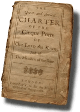
The earliest Charter granted to the Ports collectively was dated 28 May by Henry III in AD1260.
The first major official document of the Cinque Ports was created in a Royal Charter in AD1278 by Edward I, five(french cinque) ports were to maintain ships and defences for the Crown in case of attack and war,this document also referred to earlier charters which are now lost.
The chief obligation laid upon the ports, as a corporate duty, was to provide 57 ships for 15 days' service to the king annually without payment, each port fulfilling a proportion of the whole duty.
In return the towns received the following privileges:
- Exemption from tax and tallage
tax and land tax
- right of soc and sac
local laws and justice
- tol and team
tax goods passing through and exemption of government tolls
- blodwit
the right to punish shedders of blood
- fledwit
the right to punish those who were seized in an attempt to escape from justice
- pillory and tumbril
punishment of offenders
- infangentheof and outfangentheof
local punishment of thieves
- mundbryce
the breaking into or violation of a man's mund or property in order to erect banks or dikes as a defence against the sea
- waifs and strays
the landowner to take ownership of goods or animals left or straying onto their land
- flotsam and jetsam and ligan
flotsam - goods from a sunken vessel
jetsam - goods thrown from a vessel to make it lighter etc
ligan - object attached to a buoy, i.e smuggled goods
In effect the Laws of the land did not apply to the Cinque Ports.
| | |
|---|
Map of the Cinque Ports pre the 1287AD Storm ▲ |
|---|
This Map is based on a Google Relief Map and shows the high tide level at 4.5 metres higher than today to reflect the high tide level at the time
| | |
|---|
Hastings, New Romney, Hythe, Dover, Sandwich ▲ |
|---|
Hastings Hastings is always first, which is significant given everything on the Godwin page. It was the senior port, and the confederation takes its name from the number five (cinque) not from any one town. The formal charter evidence only becomes clear from the reign of Edward the Confessor onwards, though the ship-service obligation almost certainly predates that.
The two Ancient Towns — Winchelsea and Rye — were added later, both of which of course sit squarely within the old Rameslie estate that Fécamp Abbey had been administering since 1017. That is a connection worth developing — the two towns most directly under Norman ecclesiastical influence through Fécamp were formally incorporated into the confederation after the Conquest, which raises the question of whether their addition reflected a deliberate post-1066 reorganisation of coastal obligations along lines that the Normans already understood through the abbey's fifty years of local knowledge.
New Romney(Langport) was a fishing centre, but was the entrance to the Rother where other ships were made in the Newenden/Bodiam areas again due to the proximity of Andredsweald
Hythe was a fishing centre but was relatively close to modern France
Dover was a fishing centre but was the nearest point to modern France
Sandwich was another fishing centre but was protected by a shingle bar projecting northwards from Deal and protected the Wantsum channel between Kent and the Isle of Thanet.
The five ports are fairly evenly spread out along the coast providing good response speed to any offense from Europe
| | |
|---|
The AD1287 storm on the South East coast of England ▲ |
|---|
On the South coast of England in AD1287 there arose a dreadful storm which in changed the shape of the coastline.
The harbour at Hastings(this was in the Filsham valley) was destroyed and its entrance blocked by shingle, the old town of Winchelsea and Broomhill(which were on islands offshore from modern Winchelsea) were washed away and abandoned. Winchelsea was resurrected on the hill behind Ihamme overlooking Rye and old Winchelsea, and is now a beautiful town with one of the first grid layouts in England.
The thriving port of New Romney was turned into a landlocked town when massive quantities of shingle from further down the coast, along with mud and soil, inundated the town. This completely filled the harbour, blocked the river Rother and left New Romney nearly a mile from the sea with its church about 1 metre below the land and stains on the pillars marking the level of the flood.
The river Rother, which ran through the town, was blocked by the storm and found a new outlet to the sea at Rye, 15 miles away, a course that the river still takes today.
| The AD1287 storm and its effect on the independance of the Cinque Ports ▲ |
|---|
The economic effect this storm had on the Cinque Ports was that to remain independent they were still obliged to provide 57 vessels for 15 days' service to the king. Now this was impossible for the 5 ports and the 2 ancient towns as a significant number of ships had been destroyed by the storm, and also harbours blocked and towns destroyed.
| Map of the Cinque Ports after the 1287AD Storm ▲ |
|---|
 This Map is based on a Google Relief Map and shows the high tide level at 4.5 metres higher than today to reflect the high tide level at the time
Hastings lost a large proportion of its ships and men and the old Hastings harbour in the Filsham valley was now completely blocked.
New Romney suffered even more as the river Rother was now blocked completely at New Romney and broke through the shingle bank where Old Winchelsea was located, about 10 miles(14 Km) away to the west.
Hythe was badly damaged but still usable
Dover was badly damaged but still usable
Sandwich was now isolated from the sea by the shingle bar from Deal having blocked the Wantsum channel between Kent and the Isle of Thanet.
This has made 3 of the 5 ports pretty much useless so to continue with their supplying of vessels to the king they allowed other places to join the Ports which then got the benefits of the Charter. Rye and Winchelsea were known as the 'Antient Towns' and the remainder of the other places were known as 'Limbs' of the main ports.
| The addition of the Ancient Towns and Limbs ▲ |
|---|
So to mitigate the loss of ships and their supply to the King in order to keep their charter, the Cinque Ports organised other local ports to supply ships and crew, and in return these became 'limbs' of the main ports and were given the same benefits as the five original ports.
The various 'limbs' of the Cinque Ports which meant they had the same privileges are shown below, had to help the main ports to allow them to provide enough vessels for the King during the 1200 & 1300's
Hastings
- Ancient town of Rye (AD1190)
- Tenterden, limb of Rye (AD1449) — due to shipbuilding at Smallhythe
- Ancient town of Winchelsea (AD1190)
- Guestling (non-corporate limb; first documented in the 1229 ship-service record, exact admission date unknown — the Guestling court that bore its name was a separate institution)
- Bulverhythe (non-corporate limb; first documented in the 1229 ship-service record, exact admission date unknown)
- Petit Iham / Pebsham nr Hastings (non-corporate limb; first documented in the 1229 ship-service record, exact admission date unknown)
- Northeye, an island in AD1287 (non-corporate limb; first mentioned in the 1229 ship-service charter, which is the earliest documentary record of it)
- Pevensey, an island in AD1287 (corporate limb; joined before AD1230)
- Hydneye / nr Polegate, an island in AD1287 (non-corporate limb; first documented in the 1229 ship-service record, exact admission date unknown)
- Seaford (corporate limb; joined before AD1229)
- Bekesbourne nr Canterbury, inland now but on river (pre AD1285; first mentioned in the Domesday of the Ports, compiled early 13th century)
- Grange nr Gillingham Kent (pre AD1285; first mentioned in the Domesday of the Ports, compiled early 13th century)
New Romney
- Lydd (AD1155 — mentioned in the Pipe Rolls)
- Old Romney (non-corporate limb; exact date unknown, pre AD1596)
- Dengemarsh, probably near Lydd (non-corporate limb; exact date unknown, pre AD1596)
- Oswaldstone, possibly near modern Greatstone/Littlestone (non-corporate limb; exact date unknown, pre AD1596)
- Bromehill, an island near current Camber village (non-corporate limb; exact date unknown, pre AD1596)
Hythe
- West Hythe (non-corporate limb; exact date unknown, pre AD1596)
Dover
- Folkestone (AD1313)
- Faversham (AD1302)
- Margate (AD1424)
- St Johns (non-corporate limb; part of Margate, exact date unknown, pre AD1596)
- Goresend, now Birchington (non-corporate limb; exact date unknown, pre AD1596)
- Birchington Wood, now Woodchurch (non-corporate limb; exact date unknown, pre AD1596)
- Woodchurch — see Birchington Wood above
- St Peters (non-corporate limb; exact date unknown, pre AD1596)
- Ringwold (non-corporate limb; exact date unknown, pre AD1596)
- Kingsdown (non-corporate limb; exact date unknown, pre AD1596)
Sandwich
- Deal (non-corporate limb until AD1699 when incorporated by royal charter; pre AD1596)
- Ramsgate (AD1353)
- Brightlingsea (corporate limb; the only Cinque Port member north of the Thames — in Essex — exact admission date unknown but present in early 13th century records)
- Fordwich (corporate limb; the port of Canterbury on the Stour, navigable to that city until Elizabethan times; exact admission date unknown, pre AD1596)
- Sturry (non-corporate limb; exact date unknown, pre AD1596)
- Walmer (non-corporate limb; exact date unknown, pre AD1596)
- Stonar, near Richborough (non-corporate limb; exact date unknown, pre AD1596)
- Sarre (non-corporate limb; exact date unknown, pre AD1596)
- St Nicholas (non-corporate limb; exact date unknown, pre AD1596)
- Reculver (non-corporate limb; exact date unknown, pre AD1596)
| | |
|---|
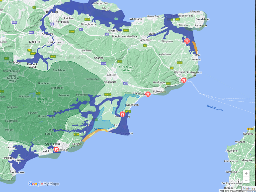
Map of the Cinque Ports together with their Limbs after 1287 ▲ |
|---|
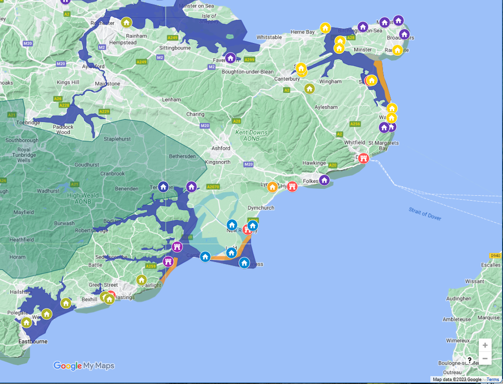
This Map is based on a Google Relief Map and shows the high tide level at 4.5 metres higher than today to reflect the high tide level at the time
The Limbs of Hastings are shown as green settlements
The Limbs of New Romney are shown as pale blue settlements
The Limbs of Hythe are shown as orange settlements
The Limbs of Dover are shown as purple settlements
The Limbs of Sandwich are shown as yellow settlements
The antient towns of Rye and Winchelsea are shown as purple castles
Finally Tenterden is shown in dark blue and is a Limb of the Ancient town of Rye
| | |
|---|
Magna Carta AD1297 ▲ |
|---|
This is a translation of the relevent clause in the AD1297 Magna Carta that was signed by Edward I and included the Cinque Ports.
(9) The city of London is to have all its ancient liberties and customs. Moreover we wish and grant that all other cities and boroughs and vills and the barons of the Cinque Ports and all ports are to have all their liberties and free customs.
| | |
|---|
Map evidence from Symonson AD1596 ▲ |
|---|
On Symonson map of Kent from AD1596 there is a list of 'Portes and their members lyinge in Kent'.
| Sandwich | Fordwich | 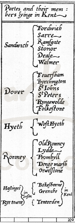 |
|---|
| Sarre |
|---|
| Ramfgate |
|---|
| Stonor |
|---|
| Deale |
|---|
| Walmer |
|---|
|
|---|
| Dover | Fordwich |
|---|
| Feuerfham |
|---|
| Byrchington |
|---|
| St Johns |
|---|
| St Peters |
|---|
| Ryngwolde |
|---|
| Folkeftone |
|---|
|
|---|
| Hyeth | WeftHyeth |
|---|
|
|---|
| Romney | Old Romney |
|---|
| Lydde |
|---|
| Promhyll |
|---|
| Denge marfh |
|---|
| Orwelftone |
|---|
|
|---|
| Haftinges | Bekesborne |
|---|
| Grenche |
|---|
|
|---|
| Rye towne | Tenterden |
|---|
| | |
|---|
Other Reading ▲ |
|---|
There is a really good article on the 'The English Navy in the Twelfth Century' which comes from Cambridge University please click the following link.
https://www.repository.cam.ac.uk/bitstreams/bd928f00-e498-4b1b-adf5-8b80c80e1492/download
|
|
|
;)


