References to locations:-
Bayeux Tapestry- 'to(towards) Pevensey'
William Sails from Normandy in 1066AD
The big ships are loaded with fighting troops and
the smaller ones carry provisions, horses etc |
The armada sails towards modern Pevensey(Pevenesæ)
please click
here to visit Reading Museum for further details of Britains Bayeux Tapestry.
|
The Carmen de Triumpho Normannico � Bishop Guy d�Amiens
And the sun shone forth brighter than usual
When Michaelmas was celebrated around the world(27th Sept 1066)
While sailors take up their oars and knights their arms
Hitherto confined, the ships spread along the coast evenly
And form themselves into a tidy fleet
The day is already short the setting sun now inclines(after midday)
When your flagship sets the course(sunrise 05:56 ->sunset 17:51 in Oct 1066)
When the dark night�s gloomy shadows overspread the sky(no moon)
On the open sea you moor offshore
You caution to take in the sails awaiting the morning to come
The third hour of the day overspread the earth(9-10am)
Since leaving the sea behind when you seize a sheltered strand
Master Wace - Roman de Rou
When the ships were ready, they were moored in the Somme at St. Valeri, and there delivered to the barons.
Many were the ships and boats in the river there, which is called the Somme, and separates Ponthieu and
Vimou. Vimou extends as far as On, which separates Normandy from Vimou, a country under different government.
Ou is a river, and Ou is also a fair castle situated upon that river.
I remember it well, although I was but a lad�that there were seven hundred ships, less four , when they sailed from
St. Valeri; and that there were besides these ships, boats and skiffs for the purpose of carrying the arms and harness.
I have found it written (but I know not whether it be true) that there were in all three thousand vessels bearing sails
and masts. Any one will know that there must have been a great many men to have furnished out so many vessels.
They waited long at St. Valeri for a fair wind, and the barons were greatly wearied. Then they prayed the convent to
bring out the shrine of St.Valeri, and set it on a carpet in the plain; and all came praying the holy reliques, that
they might be allowed to pass over sea. They offered so much money, that the reliques were buried beneath it ; and
from that day forth, they had good weather and a fair wind.
The duke placed a lantern on the mast of his ship, that the other ships might see it, and hold their course after it.
The ships steered to one port; all arrived and reached the shore together ; together cast anchor, and ran on dry land ;
and together they discharged themselves. They arrived near Hastings, and there each ship ranged by the other's side.
After the Battle
The duke placed a guard in Hastings, from the best of his knights, so as to garrison the castle well, and went thence to Romenel(New Romney), to destroy it utterly, because some of his people had arrived there, I know not by what accident, and the false and traitorous had killed them by felony. On that account he was very wroth against them, and grievously punished them for it.
Gesta Normannorum Ducum c1070 - William of Jumièges
William crossed the sea and landed at Pevensey, where at one he built a strongly entrenched fortification. He entrusted it
to his warriors and speedily went to Hastings, where he quickly raised another one. Harold, hastening to take him by surprise,
gathered innumerable English forces and, riding through the night, arrived at the battlefield at dawn.
William of Malmesbury's Chronicle
Nothing mentioned of the crossing.
Anglo Saxon Chronicles � A,B,C,D,E and H
A.D. 1066.(Version D)
Meantime Earl William came up from Normandy into Pevensey on the eve of St. Michael's mass; and soon after his
landing was effected, they constructed a castle at the port of Hastings.
Chronicles of Battle Abbey
The duke, therefore, with a prodigious army, and attended by the divine favour, arrived safely near the castle called Pevensey.
The soldiers leaped joyfully upon English ground at intervals along the shore.
As you can see from the documents, the Carmen seems to give the most detail of the journey, so lets see if this makes sense.
The calculations we have made are based on a Norman longship travelling at an average of 7 mph with the wind, but including adjustments
made for tides in the Channel.
So the important information from the documents is that they:-
- left St Valerie after midday
- sailed until the light has gone(sunset at 17:51)
- anchor offshore
- before sunrise(at 05:56) they set sail again
- arrive at Pevensey/Hastings at the third hour of the day (between 09:00 and 10:00)
To see how they could sail across channel we need firstly to look at the tides that flow through the Channel, these maps have been extracted
from pages provided by
VisitMyHarbour.com. The red dot shows the invasion starting point at St Valerie sur Sommme, the blue dot
shows the approximate landing point at Hastings.
| |
| ❮ |
1 / 24
2 / 24
3 / 24
4 / 24
5 / 24
6 / 24
7 / 24
8 / 24
9 / 24
10 / 24
11 / 24
12 / 24
13 / 24
14 / 24
15 / 24
16 / 24
17 / 24
18 / 24
19 / 24
20 / 24
21 / 24
22 / 24
23 / 24
24 / 24
❯ | | |
|
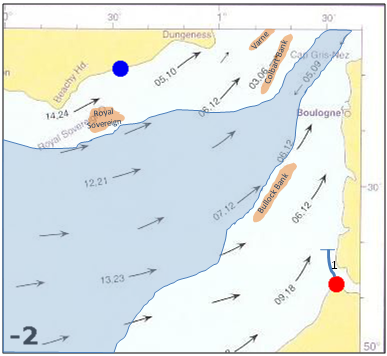
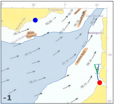
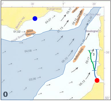
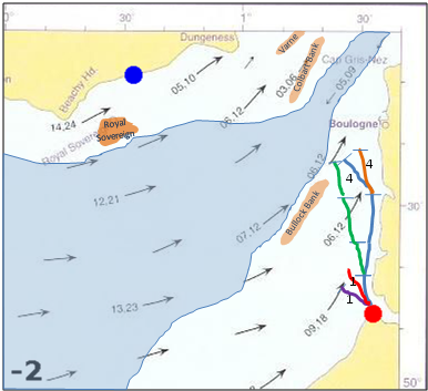
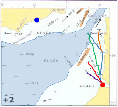
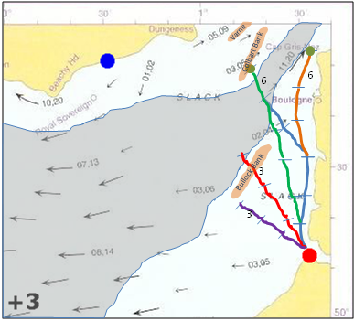
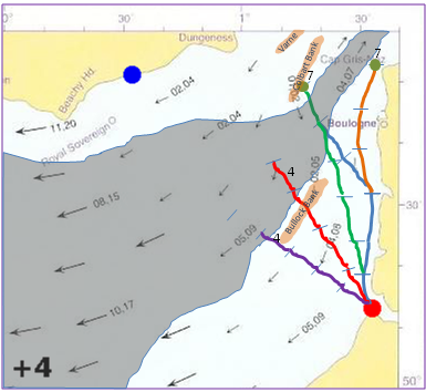
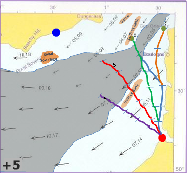
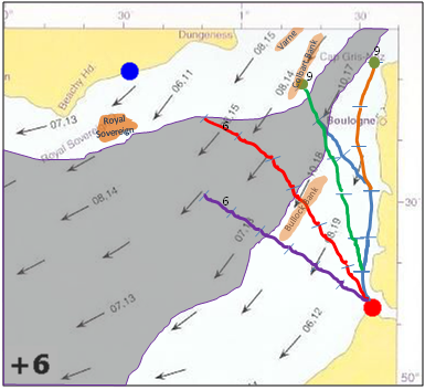
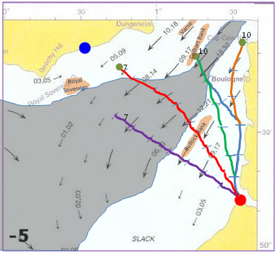
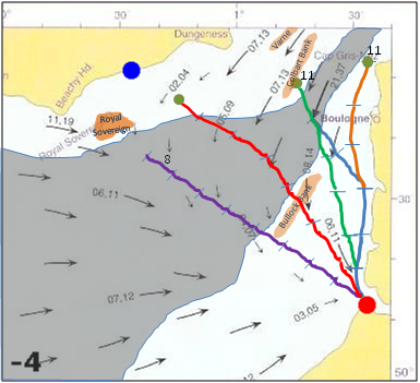
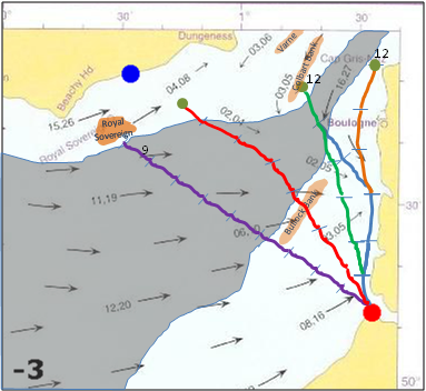
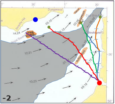
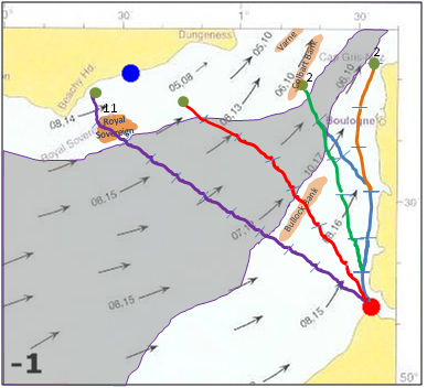
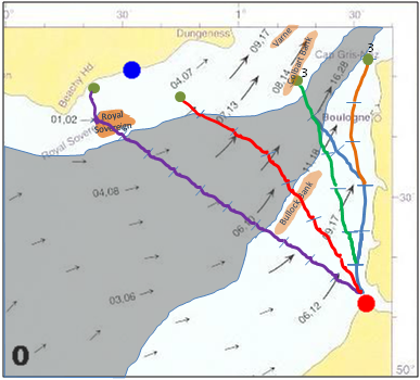
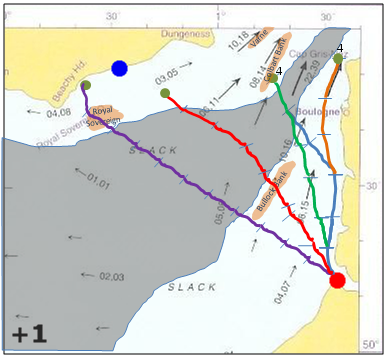
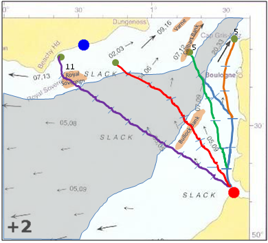
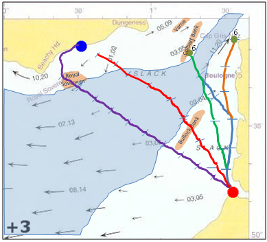
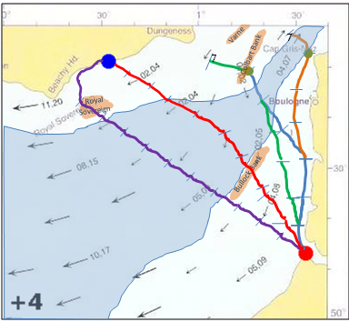
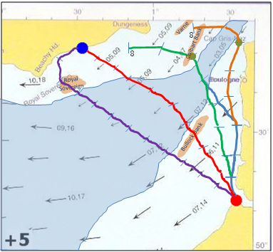
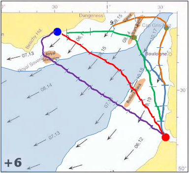
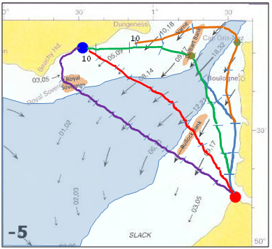
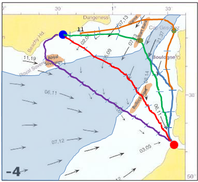
| The slideshow to the left shows the tides as they rotate from 2 hours before high tide at
Dover for 24 hours.
The map slides show deep water in blue, which is at least 50 metres deep so unsuitable for anchoring a fleet.
As you go through the slides which are 1 hourly intervals based arough the high tide at Dover you will see the plots extending as the fleet moves.
the distances shown are based on a viking ship sailing at 7mph + or - the tidal flows. The numbers against each segment of the plot show the time in
hours using a 24 hour clock.
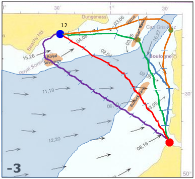
There are four plots to show potential differing routes from St Valerie to Hastings, the red dot is St Valerie, the blue dot Hastings and the green dot shows
where the fleet would need to anchor overnight, they are all set to leave St Valerie at 13.00, sail until 18.00 then anchor, these are numbered on the slides.
- Blue plot showing the most likely route as this matches with the Carmen time description.
- Orange plot showing a second route which stays nearer to land, which makes it more likely the ships will be blown onto the French Cliffs between St Valerie and Boulogne.
- The red plot is a theoretical route across the Channel, but the vessels arrive too early for the Carmen Description and anchoring in the open sea would be dangerous.
- The purple plot is based on an article by Christine and Gerald Grainge in which they describes a direct route across the Channel to Beachy Head(our thanks to Johnathan Starkey who brought this to our attention), this does however show the fleet arriving about 7am which appears too soon according to the Carmen.
Please Note tide tables for 1066 are unknown, but the flows imply the only likely routes.
|
We need to look at the bottom of the English Channel to see where it was possible for the fleet to anchor, a very nice
map from ResearchGate.net is displayed below, please click on the image to go to a pop up window of their page.

A further map of the bedrock of the English Channel from the University of Sussex is displayed below, please click on the image
to go to a pop up window of their page.
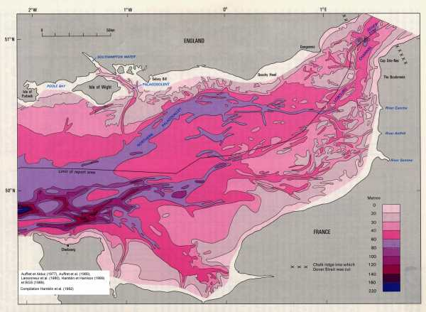
As you can see based on the depth of water the fleet would have to sail from St Valery northwards along the coast if they were to 'moor offshore'.
|