| Landscape - The History of the Romney Marsh in maps |
|---|
| |
|---|
The basis for our maps |
|---|
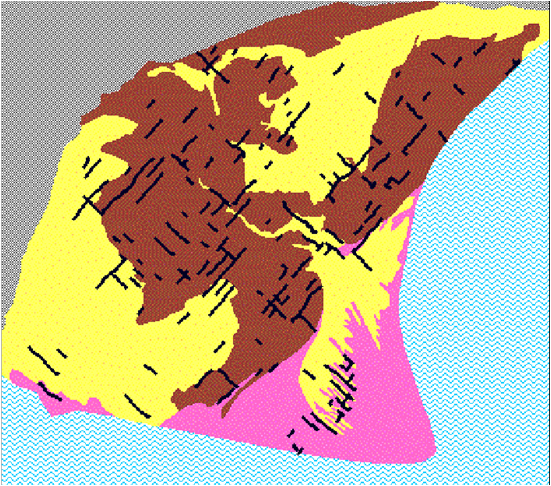
This drawing illustrates the soil age of the underlying land on the Romney Marsh.
The brown area denotes old marshland, the yellow areas new marshland and the pink areas denote areas of shingle. This map is taken from a publication from the University of East Anglia.
The "Kent A" cadastre - page 5 - Peterson 2002
Our following maps utilise the above soil structure on this map to allow us to generate maps of the land at various historic times.
Please note that the majority of the following maps were created using 'Google My Maps'.
| | |
|---|
Content |
|---|
|
| | |
|---|
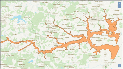
Map showing current area is close to sea level ▲ |
|---|
The blue shaded areas on this map show land that would be flooded if the sea rises just 1 metre.
| | |
|---|
Pre-Roman times ▲ |
|---|
 The Celts were extracting and exporting iron across to Gaul along the edge of the vast forest later to be called Andredsweald, and most likely building ships along the edge of the sea, that reached up the Rother valley to at the very least Bodiam, but more likely as far as Etchingham at the time.
Tidebrook near Wadhurst appears to show where the tidal reach on the Rother was at the time of the Saxon landings.
The Forest reached the sea all along the coastline from modern Appledore through to Hailsham.(Anglo Saxon Chronicles - 892AD - The Great Oak Forest of Andredsweald)
The Limen(laemen) a Saxon word meaning earthen (the modern name is Rother another Saxon name meaning Rower) flowed out to the sea at modern Hythe.
The Cliffs at Hastings would have been about 2 km further out to sea, and the residues from the cliffs would have been deposited as a shingle bank stretching from modern Pett at least to modern Camber and probably to Lydd.
Behind the shingle bank would have been the Brede, Tillingham and Rother valleys that merged near to Rye and then at Appledore.
On the edges of these rivers would have been vast areas of salt marsh.
| | |
|---|
Roman Iron Exports 1st to 4th century via Lemanis ▲ |
|---|
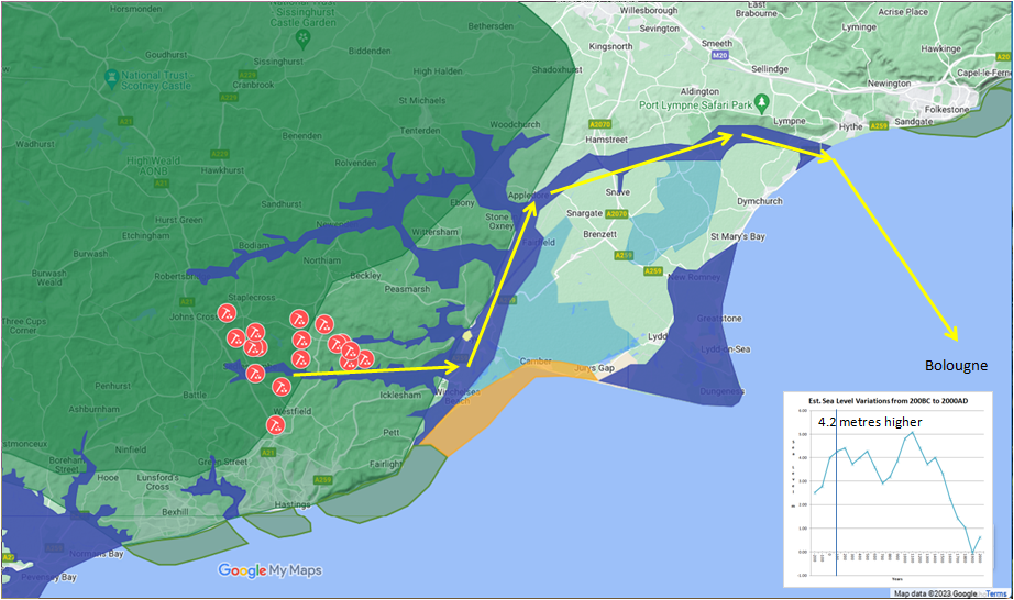
The Romans probably landed in Sandwich in 43AD and took over the country, the most likely reason was the rich iron production and the massive forest rich in oak trees that could be used for shipbuilding in the south east of the Country.
The Rother/Limen,the Brede and the Tillingham rivers were used as a main iron export route via Portus Lemanis as the Rother flowed along the top of the Marsh at this time to arrive at the sea at Hythe.
Behind Burmarsh and Dymchurch was a lagoon that was mostly salt marsh and there is evidence for salt production near Burmarsh, Snave, Newchurch and St Marys Bay in 100AD.
The fortress of Portus Lemanis was built by Carausius(The Roman Commander of the Classis Britannica who declared British independence from Rome) to defend the iron production in the Weald from the Romans in about 273AD. When Allectus, Caurausius’s successor was defeated, iron production appears to have been reduced, and possibly limited by the State to only produce enough iron for shipbuilding. This would seem to have been to prevent another usurper being able to build a fleet and also to hold Rome to ransom over the iron it needed for weapons.
After the Romans left England around 410AD Henghest and Horsa, mercenaries from Jutland, were paid by King Vortigern of Kent and in 449AD were given land in the South East of the county, probably near the old Roman Fortress at Lemanis.
An interesting article on Roman European iron production can be found here on the American National Library of Medicine website.
| | |
|---|
Roman Iron Exports 1st century ▲ |
|---|
Small bloomeries taken over from the Celts 150tons/annum
| | |
|---|
Roman Iron Exports 2nd century ▲ |
|---|
Expanded exploration area 700 tons/annum
| | |
|---|
Roman Iron Exports 3rd century ▲ |
|---|
Major production from less larger bloomeries 450 tons/annum
| | |
|---|
Roman Iron Exports 4th century ▲ |
|---|
125 tons/annum
Roman Iron production
- 43AD - 100AD = 150 tons/year ( 8550 tons)
- 100AD - 150AD = 700 tons/year (35000 tons)
- 150AD - 200AD = 750 tons/year (37500 tons)
- 200AD - 250AD = 750 tons/year (37500 tons)
- 250AD - 300AD = 200 tons/year (10000 tons)
- 300AD - 350AD = 200 tons/year (10000 tons)
- 350AD - 400AD = 50 tons/year ( 2500 tons)
Overall about 141050 tons of smelted iron was exported
Source of this data is the Wealden Iron Research Group.
| | |
|---|
The Ancient Northern Course of the Rother ▲ |
|---|
|
The river that the Romans called the Limen, and which the Saxons later renamed the Rother, did not always reach the sea where it does today. In the Roman period and for much of the early medieval period, the river ran along the northern edge of what is now the Romney Marsh, following the line of the old cliff that once formed the coastline before the marsh accumulated behind it.
From its upper valley the river swung north at what is now Maytham Wharf and ran via Small Hythe, Reading Street and Oxney Ferry to a point south of Appledore. From there it turned south and entered the sea in the area of modern Hythe — which is why the Romans built their fort of Portus Lemanis on the cliff above that outlet, commanding both the river and the tidal inlet below it. The channel from Maytham to Appledore along this northern route corresponds substantially to what is now known as the Reading Sewer, a drainage channel still visible on the modern map running along the foot of the Wealden escarpment.
The Royal Military Canal, built between 1804 and 1809, follows this same ancient line. The Napoleonic engineers did not invent that route — they recognised it as the natural low ground along the old cliff foot and cut their canal along it. The canal therefore preserves, in its alignment, the memory of the original course of the Rother across the top of the marsh.
This northern route remained the dominant course of the river through the Roman period and into the Saxon period. It was the route along which iron from the Wealden bloomeries was moved by barge down to Portus Lemanis and thence across the Channel.
The river's exit at Hythe was eventually blocked — most likely by storm-driven shingle movement, possibly in the event recorded around 566 AD — forcing the Rother to break through to the sea at Old Romney instead. By 893 AD this Romney exit was established, as the Anglo Saxon Chronicle records the Viking fleet sailing into the mouth of the Limen at that location and towing their ships four miles upriver into the Weald. That diversion set in motion the sequence of silting, channel changes and drainage works that the subsequent sections of this page describe.
| | |
|---|
Pre 740AD most likely after 566AD ▲ |
|---|
The first written reference to Romney is dated 740AD in a grant of King Ethelbert which mentions the chapel of St. Martin being located here. Sometime before this the Rother/Limen changed its course from where it originally reached the sea at Hythe and broke through to the sea at ‘Old’ Romney.
There is a report of a storm in 566AD which hit the South East and effected Hampshire, Sussex and South Kent which most likely caused the blocking of the mouth of the river with shingle and the re-routing of the Rother to reach the sea via Romney. (Sussex Archaeological Collections Relating to the History and ..., Volume 27)
There are also reports of a major storm surge in 586AD in the Thames, which could also have effected this coastline, however the north sea storm surges rarely hit the South Kent and Sussex coasts so this is less likely.
It is probable that one of these events blocked the exit of the Rother/Limen at Hythe forcing the river to break through to the sea at ‘Old’ Romney.
It is likely that one of these storms also created the shingle banks at Old Winchelsea and Broomhill where the later villages were founded.
| | |
|---|
Map for a Major storm in the Channel 566AD ▲ |
|---|
| | |
|---|
Evidence for a 566AD Storm ▲ |
|---|
The first record I found for a storm was in the 'Tablet of Memory' a book from 1774AD, but it didn't record its source for this. The record simply says:
566AD A great storm on the southern coast of Britain.
Now is there evidence for this in Geological core samples
| Event |
Key Source |
Dating Method |
Estimated Date |
Access |
| Romney Marsh flooding | Long et al. (2007) | Radiocarbon (peat/sand) | 520–550 AD | GeolSoc | | Pevensey marine incursion | Wallace et al. (2019) | AMS radiocarbon | 450–550 AD | DOI | | Rye tsunami/storm | Haslett & Willis (2016) | OSL (gravel) | ~520 AD | DOI | | 536 AD climate event | Sigl et al. (2015) | Ice cores | 536 AD (+541 AD) | Nature |
Now the evidence for a serious flooding event around the 500's appears to be valid, obviously the date may or may not be correct, as the source was likely written from a persons memory.
However a serious flood in the channel will most likely come from the South West, so would move shingle from the marsh to the East, and hence could block the Rother/Limen access to the sea at Portus Lemanis.
| An Alternate map from the National Trust museum at Smallhythe ▲ |
|---|
The following map is an alternate view of the Marsh from an undated map at the National Trust Smallhythe Place, it doesn’t match with the age of the land from the University of East Anglia map(at the top of this page), but has been used as a basis for a lot of subsequent maps of the Romney Marsh.
I believed it was worth showing what others had thought of the early Marshes.
| 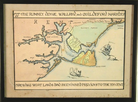
An undated map from the National Trust Ellen Terry museum at Smallhythe Kent.
| 
This map comes from a small booklet 'About New Romney' published by Invicta Publishing - I cant find an online reference to this booklet but its quite an interesting booklet if you can find it.
| | |
|---|
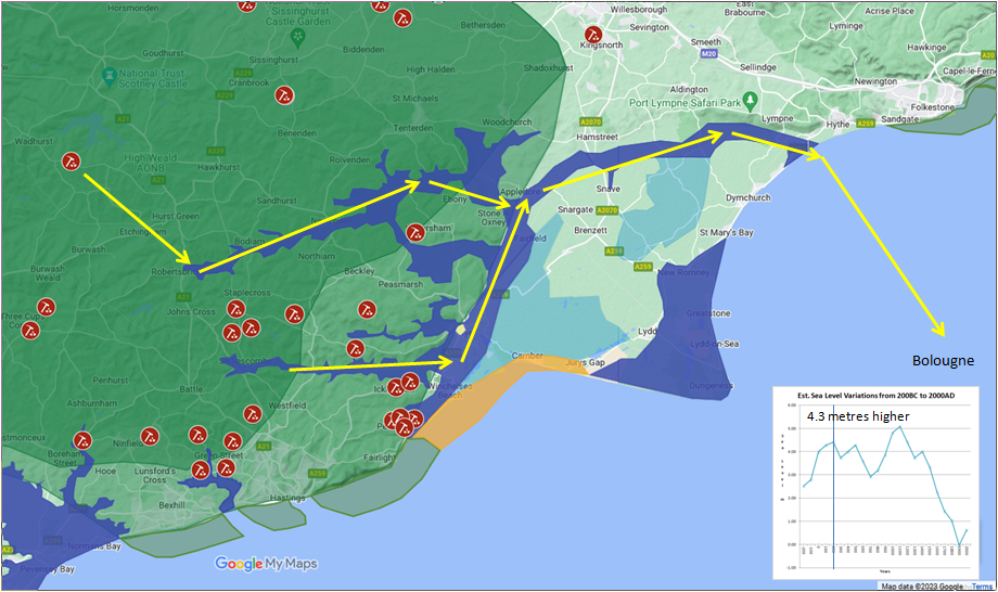
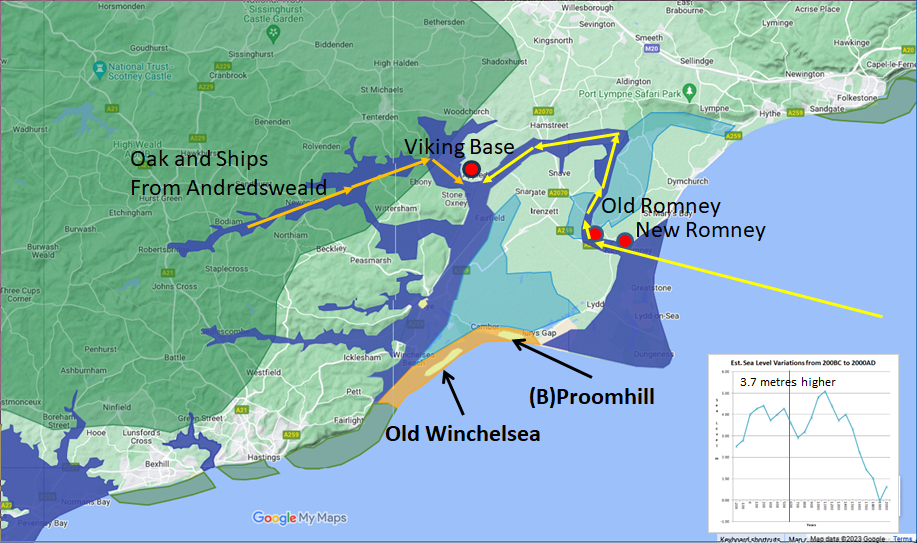
893/894AD The large Viking Army and Appledore ▲ |
|---|
Anglo Saxon Chronicles:
A.D. 893. This year went the large army, that we before spoke about, back from the eastern district westward to Bologne; and there were shipped; so that they transported themselves over at one time with their horses withal. And they came up with two hundred and fifty ships into the mouth of the Limne, which is in East-Kent, at the east end of the vast wood that we call Andred. On this river they towed up their ships as far as the weald, four miles from the mouth outwards; and there destroyed a fort within the fen, whereon sat a few churls, and which was hastily wrought.
A.D. 894. Hasten was there with his gang, who before were stationed at Milton, and also the main army had come thither, that sat before in the mouth of the Limne at Appledore.
The main Viking army appears to have remained at Appledore (in the area protected from the weather behind the Isle of Oxney) for an extended period of time, perhaps this was to rebuild and make new ships from the Wealden Oak that lay alongside the Rother, as there was not much else around the area at the time except saltmarsh and woodland.
The main Saxon settlement was at Old Romney, with the Langport at New Romney at the time, so the Viking fleet must have passed these villages, and probably killed all or were welcomed by the locals.
| | |
|---|
Map for 893/894AD The Large Viking Army and Appledore ▲ |
|---|
| | |
|---|
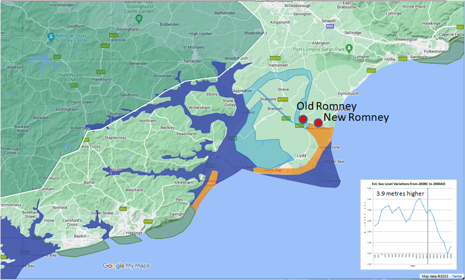
Post 900AD New Romney and Langport ▲ |
|---|
The slow moving Rother now silted up the area around Old Romney, and the port had to be moved to modern New Romney in the late 900's AD, where it was known as Langport.
In 1066AD the Normans sacked New Romney as it was claimed that some ships landed prior to the battle most likely due to taking on water and sinking. The Portsmen killed all the Normans onboard and suffered as a consequence.
A couple of refernces to this even are found from the following Chroniclers.
Master Wace
The duke placed a guard in Hastings, from the best of his knights, so as to garrison the castle well, and went thence to Romenel, to destroy it utterly, because some of his people had arrived there, I know not by what accident, and the false and traitorous had killed them by felony. On that account he was very wroth against them, and grievously punished them for it.
William of Jumièges
After providing for the decent interment of the dead the duke marched to Romney, and taking it by assault, revenged the slaughter of a party of his troops, who, having landed there by mistake, were fiercely attacked by the inhabitants and cruelly butchered, after great loss on both sides.
There is also a possibility that the English sailors from Langport were attacking the French Fleet as it passed by on its way to Pevensey/Hastings but the Chroniclers(mostly Norman) wouldn’t have wanted it known that the English had any successes.
| | |
|---|
Map for Post 900AD New Romney and Langport ▲ |
|---|
| | |
|---|
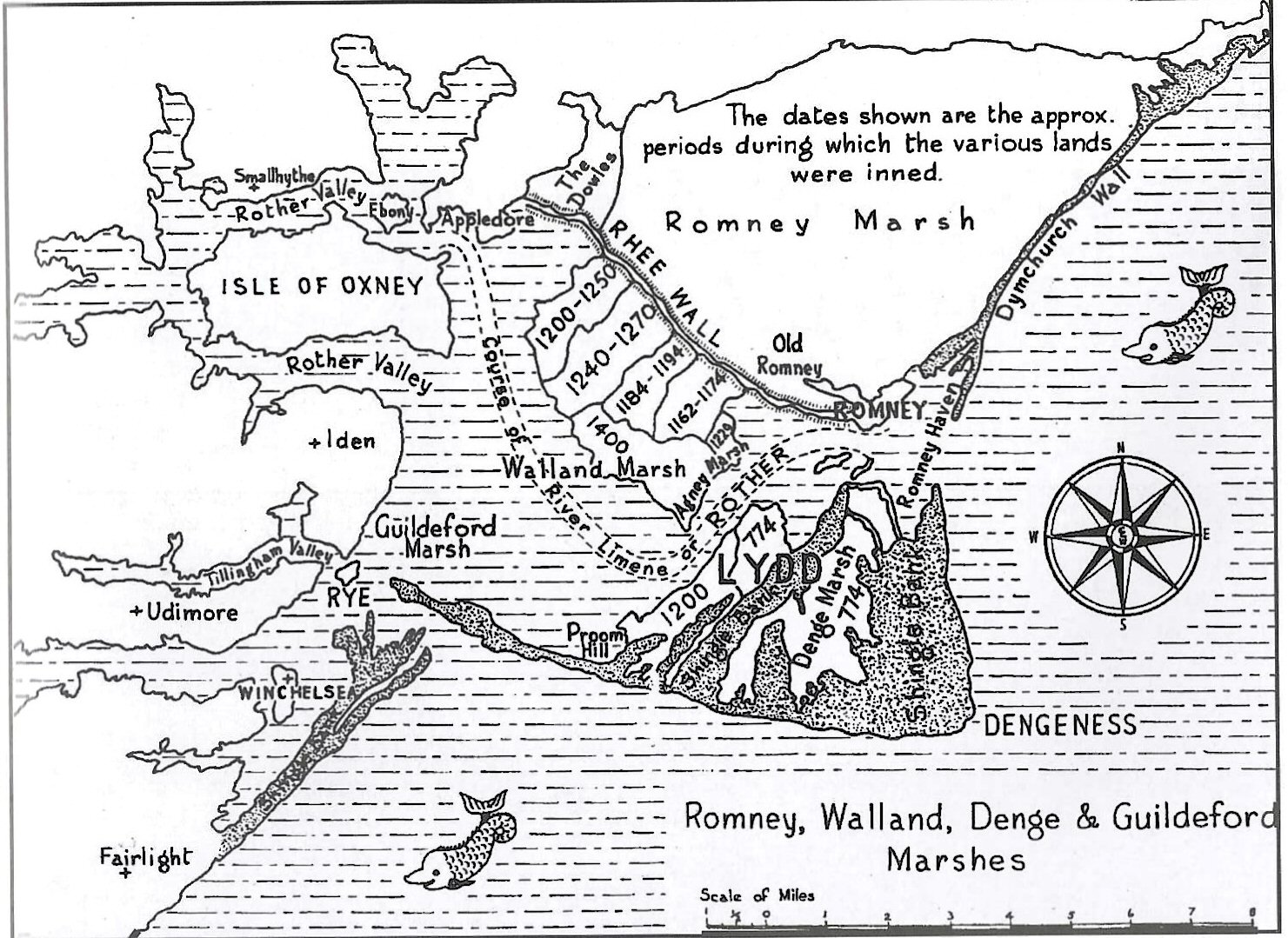
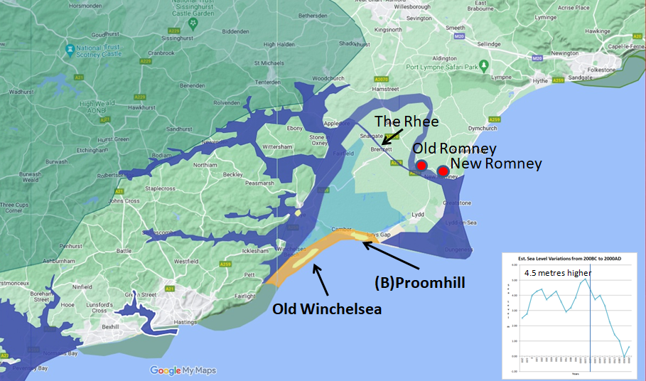
1200AD the Rhee Wall ▲ |
|---|
As time passed the Rother started to silt up its entrance to the sea producing a delta, this made the Port of Old Romney in turn silt up.
This was seriously effecting old Romney and the Langport at New Romney, so that in the early 1200’s a channel was cut from Appledore to Old Romney via Snargate, called the ǽ (Saxon for watercourse – now called the Rhee) this most likely became the course of the Rother once it was built.
A great gate at Snargate was made to hold the water from the Rhee back as the tide lowered which could then be released so that it flushed the silt from Langport into the sea.
Over the next few years as the Rother deposited silt further out to sea making the new harbour less deep so in 1250AD the Rhee was extended to New Romney.
The new channel in turn allowed the area behind Dymchurch to dry out producing the rich farmlands of today.
| | |
|---|
Map for 1200AD the Rhee ▲ |
|---|
| | |
|---|
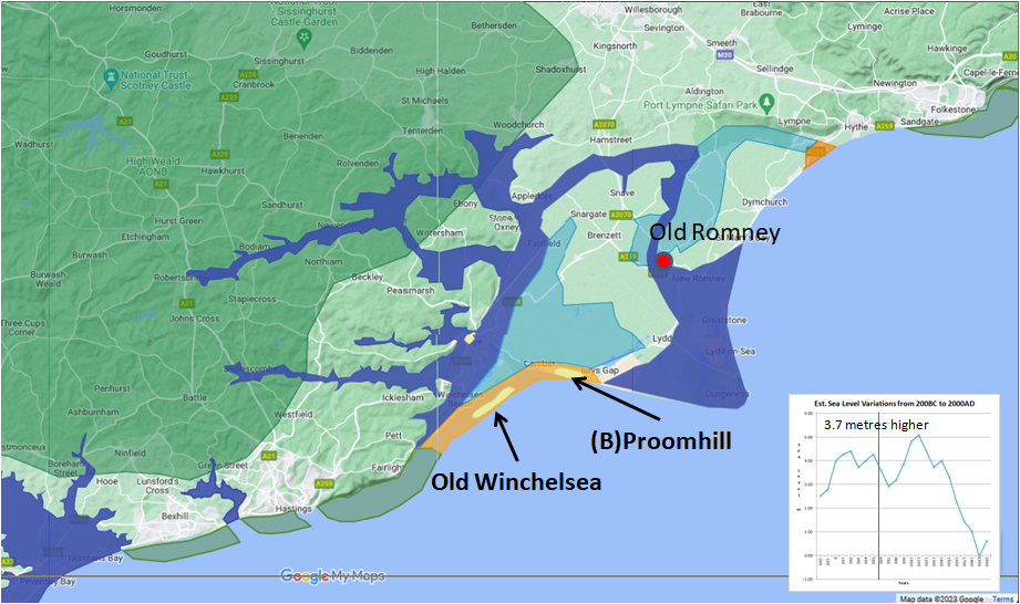
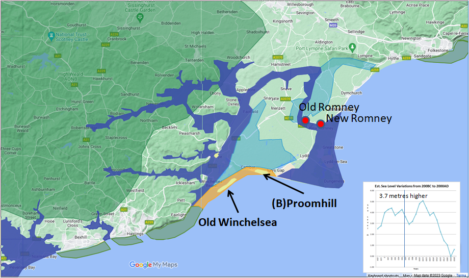
1287AD the Great Storm ▲ |
|---|
In February 1287AD a great storm hit the south coast effecting Kent and Sussex, the marsh suffered extreme damage and Old Winchelsea (offshore from current Winchelsea) and Proomhill(Bromhill) were completely washed away and about 1 metre of shingle swept over New Romney effectively blocking the exit of the Rother.
The Rother broke its banks near to Old Winchelsea and the Rother flowed south of the Isle of Oxney to the sea at Rye.
The Rhee channel, now a redundant waterway overtime became filled in and is now turned into a road. The banks are now known as the Rhee Wall due to the protection they brings to the below high tide level land near Newchurch.
This storm also seriously damaged Hastings (probably sealing its port) and most of the other ‘Cinque Ports’, requiring the main ports to attach Limbs(smaller ports) and Antient towns to provide the 57 ships and crew required by the king for 15 days a year and hence keep their independent rights.
| | |
|---|
Map for 1287AD the Great Storm ▲ |
|---|
| | |
|---|
Consequences of the Storm ▲ |
|---|
New Romney was now a member of the Cinque Ports in title only, as they had no harbour, and over time it lost its power.
The Cinque ports had a major problem now as Hastings, New Romney and Sandwich harbours had been effectively blocked by shingle banks, so Limbs(additional ports) were added to the 5 main ports.
Rye and Winchelsea soon overtook the Hastings and New Romney as major hubs of the Cinque Ports.
On the marshes various Archbishops of Canterbury now extended their lands by ‘inning’ (surrounding the marshy areas with walls and then draining the marsh) between the Rhee Wall and modern Camber. Inning was a cheap way to increase their landholding without paying tax, and so made the church wealthier.
| | |
|---|
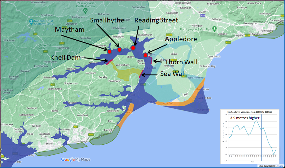
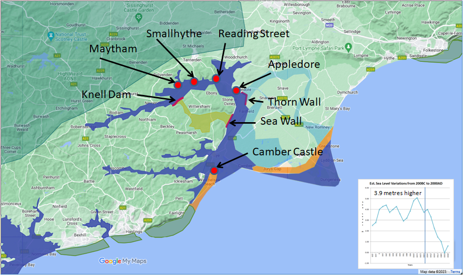
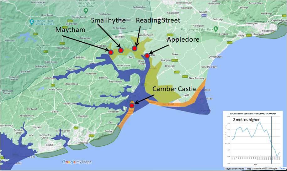
The Knell Dam 1332AD ▲ |
|---|
The rerouting of the Rother south of the Isle of Oxney allowed the sea tides to flow right up the Rother valley as far as Bodiam. Marshland which had previously been valuable as summer pastures to provide food for an increasing population was no longer available.
By 1330 the flooding had become worse, and in 1332 two local landowners, Isabella Aucher who lived near Newenden on the Kent side, and Geoffrey de Knelle who lived in Sussex, petitioned the king for permission to make a wall at a place called Knellesflete. This was granted, and in the next few years the Knelle Dam was built.
There were other Dams built around this time, the Sea Wall across the southern edge of the Wittersham level and the Thorn Wall between Appledore and the marsh.
The Dams/Walls thus diverted the river waters and numerous tides round the north side of Oxney, there it promoted harbours at Maytham, Small Hythe, Reading Street and Appledore. These were small but of national importance to Henry V in 1415 and even to Henry VII in 1517 for warship construction.��After the storm, and possibly before, the land on the Newchurch side of the Rhee was drained and turned into rich farmland.
| | |
|---|
Map for The Knell Dam 1332AD ▲ |
|---|
| | |
|---|
Camber and the Castle 1512AD ▲ |
|---|
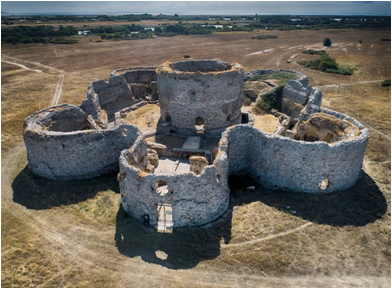 Camber is a new name and was used to describe the protected sea area between modern Camber, Camber Castle and Rye which was used to harbour the fleet (originally provided by the Cinque Ports but which became the Royal Navy in 1546) from the weather in the channel, it is derived from the French ‘la Chambre’ meaning the chamber.
Camber Castle also known as Winchelsea Castle was built by Henry VIII to defend the western entrance to the Camber and to protect Winchelsea and Rye, and the main wealden shipyards at Maytham, Smallhythe and Reading(Street) on the Rother near modern Tenterden.
The Castle was completed between 1512
and 1514 but was badly built and required expensive modifications in 1542/3 to make it effective, but became obsolete by 1637 as
the silt from the Rother and longshore shingle drift from the Fairlight Cliffs moved the coastline further towards Camber.
This increased the distance from the castle to the sea of the 28 brass and iron guns mounted on the turrets, hence making them ineffective.
| | |
|---|
Map for Camber and the Castle 1512AD ▲ |
|---|
| | |
|---|
1541AD Gun manufacture at Robertsbridge ▲ |
|---|
The following is an extract from the excellent resource from the Wealden Iron Research group:
Wealden Iron Research Group - 'Robertsbridge – Technology and Location'
Because of the rich iron deposits around the area, a furnace was built near Robertsbridge in 1541AD, but this fell into disuse during 1546AD.
ROBERTSBRIDGE ABBEY FORGE 1541AD - 1801AD:
This important forge built in 1541AD really ran as one unit with the Robertsbridge furnace, but had a separate pond some 400 yards below the furnace pond, both now dry. From it was the unusual feature of a leat or dyke, about 300 yards long, running E. and cutting deeply through high ground, to the forge site, SE. of the Abbey.
Whistler Webster of Battle Abbey leased Robertsbridge Furnace to a Staffordshire ironmaster John Churchill in 1754AD and iron quarries in this area to Edward Sackford in 1756. The Sussex ironmasters, William Polhill of Hastings, David Guy of Rye and James Bourne of Salehurst were leasing Robertsbridge Furnace in 1768AD.
The requirement of the Board of Ordnance in 1757AD was that the iron guns they purchased should be cast from ore prevented the expansion of a London-based gun-casting trade using air furnaces.
'Churchill’s initial proposal to the Board was for 200 tons of ordnance which, over an assumed average campaign of thirty-three weeks, is not unreasonable compared with the output level of seven to eleven tons a week quoted by the estate three years earlier. Churchill doubled his proposed output for 1759, and it is presumed that he was able to make this offer by running Darwell Furnace as well as Robertsbridge.'
'Ironworks probably had at least one wagon team to carry out the various transport tasks necessary through the year, but other teams were hired from neighbouring farms, such as Stephen Goodsall’s team at Udiam Farm which carried guns from Robertsbridge Furnace to Maidstone, or along the short distance to Udiam Bridge where they were off-loaded on to barges bound for Rye.'
This shows that heavily laden cannon barges could still reach Udiam Bridge which is just upstream from Bodiam in the mid 1700's
| | |
|---|
1636AD End of the Knell Dam ▲ |
|---|
The Wittersham levels had been drained since the Knell Dam was built, but this had caused the area around Newenden to flood and remain flooded.
In 1600 “or thereabouts” a breach occurred in the Knell Dam(Maytham Wall). The Newenden levels emptied into the Wittersham level and "within 10 days" all the Drowned Lands(area between Newenden and Appledore) were drained. The Commissioners for the Newenden levels thereupon made 3 successive proposals to Wittersham to allow the breach to stay open for drainage, but were turned down and the Dam was rebuilt.
The Rother continued to silt up the north of the Isle of Oxney, until By 1636AD the Rother had deposited a great deal of silt to the north of the Isle of Oxney, and the harbour at Rye was under threat of closure as the Rother had slowed. So a channel was proposed through the Wittersham Levels to enable the flooded Newenden Levels and Rother to flow faster to the sea and clear Rye harbour.�
An agreement was reached in 1663AD to carry out the making of a channel through the Wittersham levels, but a storm in late 1633AD broke through the dam and flooded the Wittersham Levels, a channel was then cut through the area and the Rother now flowed south of the Isle of Oxney, and still does.
| | |
|---|
End of the Knell Dam 1636AD ▲ |
|---|
| | |
|---|
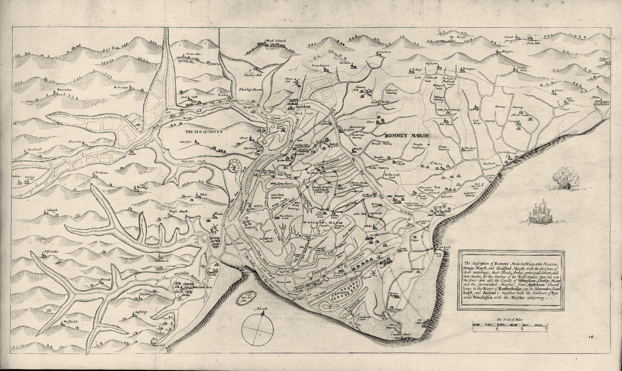
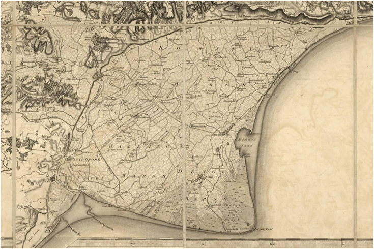
1662AD William Dugdales Map ▲ |
|---|
In 1662AD a detailed map was published by William Dugdale showing all the waterways and channels of the Romney Marsh
This map shows the ‘Sea Wall’ between Iden and the Isle of Oxney, the ‘Thorn Wall’ near Appledore and the ‘Knell Dam/Wall’ all standing, hence the survey of the map must have taken place pre 1636AD as that was when the Knell Dam failed and the Rother started flowing south of Oxney.
The map was titled:
"The Description of Romney Marsh, Walland Marsh, Denge Marsh, and Guildford Marsh, with the Divisions of their Waterings, their Heads, principal Sewers, and their Guts, for the sewing of the Fresh Waters that fall into the same: And also the Levels of Wittersham, Sherley Moor, and the surrounded Marshes, from Appledoure, Chanell, lying to the River of Rotherbridge, up to Newenden, Sandhurst, and Bodiam; together with the Harbours of Rye and Winchelsea, with the Marshes adjoining."
and comes from:
‘The history of imbanking and drayning of divers fenns and marshes, both in forein parts and in this kingdom, and of the improvements thereby extracted from records, manuscripts, and other authentick testimonies’ / by William Dugdale.
Dugdale, William, Sir, 1605-1686.
London: Printed by Alice Warren, 1662.
https://quod.lib.umich.edu/e/eebo/A36795.0001.001/1:4.30?rgn=div2;view=toc
Refer to Cap XI
https://quod.lib.umich.edu/e/eebo/A36795.0001.001/1:4.11?rgn=div2;view=fulltext
| | |
|---|
William Dugdales map of Romney Marsh in 1662 ▲ |
|---|
| | |
|---|
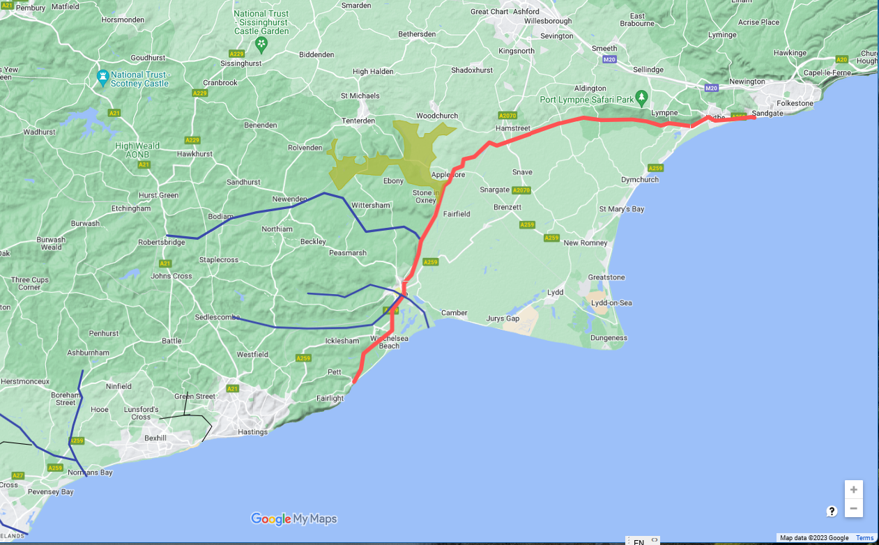
Royal Military Canal 1804AD-1809AD ▲ |
|---|
The ‘Royal Military Canal’ is a canal running for 28 miles (45 km) between Seabrook near Folkestone and Cliff End near Hastings, following the old cliff line bordering Romney Marsh, which was constructed as a defence against the possible invasion of England during the Napoleonic Wars.
As you can see it follows much of the original course or the river Rother/Limen in Roman times.
The Canal has help the draining of the land and the reclamation of the remaining marshy areas, this means that the Romney Marsh and Rother Valley is mostly rich fertile farmland.
| | |
|---|
Map for Royal Military Canal 1804AD-1809AD ▲ |
|---|
| | |
|---|
First 1 inch Ordnance Survey map 1801AD ▲ |
|---|
The origins of the Ordnance Survey lie in the aftermath of the Jacobite rising of 1745. Prince William, Duke of Cumberland realised that the British Army did not have a good map of the Scottish Highlands to locate Jacobite dissenters such as Simon Fraser, 11th Lord Lovat so that they could be put on trial.
In 1747, Lieutenant-Colonel David Watson proposed the compilation of a map of the Highlands to help to subjugate the clans.
In response, King George II charged Watson with making a military survey of the Highlands under the command of the Duke of Cumberland. The survey was produced at a scale of 1 inch to 1,000.
In 1801, the first one-inch-to-the-mile (1:63,360 scale) map was published, detailing the county of Kent, with Essex following shortly afterwards. The Kent map was published privately and stopped at the county border, while the Essex maps were published by the Ordnance Survey and ignored the county border, setting the trend for future Ordnance Survey maps.
Above details are from the Wikipedia article
| | |
|---|
Revised 1809AD to include the Royal Military Canal ▲ |
|---|
| | |
|---|
1849AD Salehurst ▲ |
|---|
extract from 'A History of the Weald of Kent: With an Outline of the Early History of the County' by ROBERT FURLEY
'After the Marsh had been reclaimed from the sea, and the waters from the Weald discharged at Eye(Rye), but down to 1849 and later the sea had access up the valleys of the Rother, to Salehurst, as the Lord of the Manor of Etchingham
complained, 22nd Edward 3rd (Dugdale p. 84) of some doings below at Knell's Dam, or between Knell's Dam and Newenden, by which boats with merchandise could not reach his market at Salehurst.'
This extract shows that ships could still get to Salehurst even in the mid 1800's.
| | |
|---|
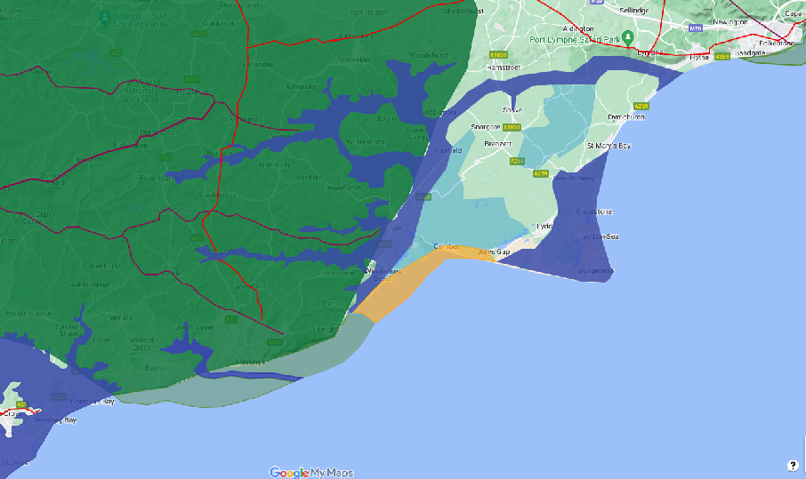
Present day ▲ |
|---|
Since the publication of Dugdales map the Rother has silted up more, the Environment Agency has a sea lock at Rye that protects the Rother Valley from sea water incursion however flooding in the Rother valley still takes place due to high volumes of run off from the local hills. The map below is from https://floodassist.co.uk and shows the extent of a flood warning from 05-Nov-2023
The Ness at Dungeness has grown bigger as the Hastings cliffs fall into the sea and New Romney is now a long way inland. � Between 1966 and 1980 an improvement scheme was installed. The river banks were raised throughoutmost of its length to increase storage and avoid overtopping .
| | |
|---|
Romney Marsh - Present Day ▲ |
|---|
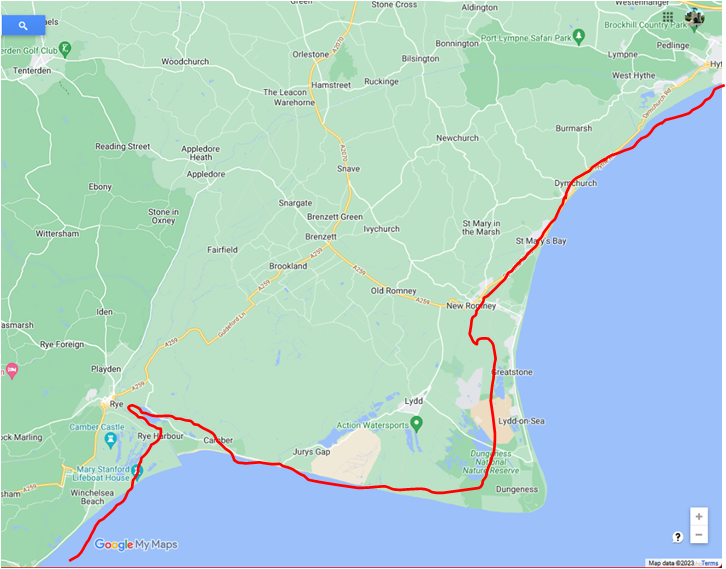
This is today and also shows the difference to Dugdales map.
|
|
|
;)