| Saxon Place Names (hythe, hithe etc) |
|---|
|
Place names containing hythe, hithe, hyde or the Saxon original hyð are relatively rare in England — which is itself a clue to their significance. The Anglo Saxon Dictionary defines hyð as a landing place, a low shore fit for bringing boats ashore, a port or haven. But if hyð simply meant any port or landing place, we would expect far more of them.
This page argues that the scarcity of hyð names, and their distribution — one per county or region, always on the coast or a major navigable river — suggests they were not general terms for harbours but specific names marking the original landing points of the Saxon tribes who settled those areas. They are, in effect, a map of the Saxon invasion recorded in place names.
The sea level argument is central to understanding this distribution. At current sea levels, the hyð names appear scattered and random. Raised to the 4.5 metre tidal level of early Saxon times, they snap into alignment along what would then have been the coastline and tidal river reaches. Before reading further it is worth looking at Places containing the snippet æg meaning island for the full evidence behind that 4.5 metre figure.
| | |
|---|
Saxon place names containing hythe/hithe/hyde (hyð) |
|---|
This originates from the Saxon word hyð where the ð is pronounced th so sounded like 'hieth', however it could also be spelt hyþ due to the two following two similar Saxon characters
Eth Ð(upper Case) ð(lower case) Pronounced th as in then
Thorn Þ(upper case) þ(lower case) Pronounced th as in thin
This also means that over time we also have the possibility of hythe, hithe and hyde if Eth was used to write the name, and other derivations such as ryde.
The definition of hythe from the Anglo Saxon Dictionary
'A HITHE, or place that receives the ship, etc., on its landing; a low shore, fit to be a landing place for boats, etc.,a port, haven'
hyþe, where bootys ryve to londe, or stonde stacio. Hithe occurs in the names of seaports, and also landing-places on rivers, far from the coast, ,Rotherhithe (hrýðra hýð) the place where oxen were landed; Clayhithe, near Cambridge; Erith (Eárhýd), in Kent and Cambridge, Queenhithe (Cwénhýð).
| The hyð`s where are they |
|---|
The list below is not exhaustive but provides a good starting point
- Beckhithe - Norfolk (bec hyð) meaning 'the port by the stream'
- Broad Hythe - Moray (bræd hyð) meaning 'the broad port'
- Bulverhythe - East Sussex (burgh wær hyð) meaning 'the port of the hill/fort people'
- Clayhithe - Cambridgeshire (clæg hyð) meaning 'the clay port'
- Covehithe - Suffolk (cofa hyð) meaning 'the cove/cave port'
- Downham Hythe - Cambridgeshire (dun hamm hyð) meaning 'the valley port by the hillfort/hill'
- Egham Hythe - Surrey (æg hamm hyð) meaning 'the valley port on the island'
- Erith - London (eár hyð) meaning 'the port on the sea'
- Greenhithe - Kent (grene hyð) meaning 'the grassy port'
- Hythe - Kent (hyð) meaning 'the port'
- Hythe - Hampshire (hyð) meaning 'the port'
- Hythe End - Windsor (hyð end) meaning 'the port of old'
- Lambeth - Surrey (lamb hyð) meaning 'the port of lambs'
- Methwold Hythe - Norfolk (mæþ wold hyð) meaning 'the mowing port by the high forest'
- New Hythe - Kent (niwe hyð) meaning 'the newer port'
- Portknockie Hythe - Moray (port chnocaidh hyð) meaning
'port(probably added when the meaning of hyð was lost) the hilly port'
- Rotherhithe - London (hrýðra hýð) meaning 'the oxen port'
or ( róðer hýð) meaning 'the rowers port'
- Queenhithe - London (Cwén hyð) meaning 'the queens port'
- Smallhythe - Kent (smæl hyð) meaning 'the small port - possibly the secondary port'
- The Hythe - Essex (hyð) meaning 'the port'
| Map of the hyð`s |
|---|
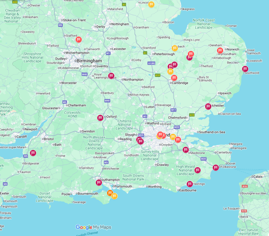
This map shows the location of Hythes shown in maroon, hithes shown in red and eth's shown in orange. They seem to be random throughout the country.
Click on map for larger image
| Map of the hyð`s with the 4.5 metre high tide |
|---|
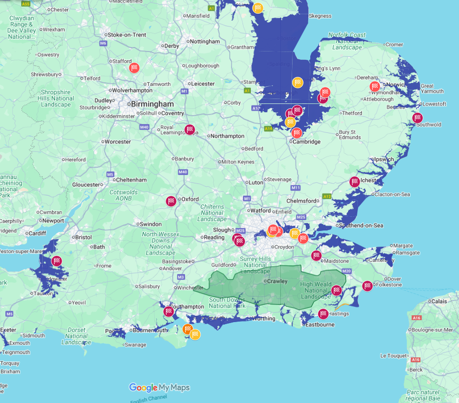
This map shows the location of Hythes shown in maroon, hithes shown in red and eth's shown in orange with the high tide level shown. Now they all seem to be on the coastline, or major rivers.
Click on map for larger image
| |
The first map plots all the known hyð place names against the current coastline. At first glance they appear scattered, with no obvious pattern — some are coastal, some are well inland, and there is no clear logic to their distribution.
The second map overlays the same locations with the 4.5 metre high tide level of early Saxon times. The transformation is striking: almost all of the hyð names now sit directly on the coastline or on tidal reaches of major rivers. Clayhithe and Downham Hythe in Cambridgeshire, currently well inland, fall on what would have been the tidal Fen edge. Lambeth and Rotherhithe in London sit on what was a much broader tidal Thames. The apparent randomness of the first map was not randomness at all — it was the result of looking at a Saxon coastal map through a modern lens.
This is the same pattern seen with the æg island names on the Pevensey and Wash pages: place names that appear anomalous at current sea levels make immediate geographical sense once the early Saxon tidal range is restored.
| | |
|---|
My Conclusion |
|---|
|
The hyð names form a coherent and distinctive group. They are few in number, they are always associated with water — coast or navigable river — and when mapped against the 4.5 metre tidal level of early Saxon times, they align precisely with what would then have been accessible landing beaches and tidal harbours.
The conventional definition — a landing place, a port — is correct as far as it goes. But it does not explain the scarcity, or the pattern of roughly one per county or tribal territory. A general word for harbour, used freely by any community near water, would produce dozens of examples per county, not one or two across a whole region.
The most plausible explanation is that hyð names were not given to everyday working harbours but to places of particular significance — the specific beaches and river mouths where a tribe or warband first came ashore. Each one marks a moment of arrival, a point of origin. Together they sketch the outline of the Saxon settlement of England, one landing place at a time.
| | |
|---|
Hyð the starting(first landing) points for the individual Saxon tribes. |
|---|
|
Working through the list with this hypothesis in mind produces some suggestive matches with what the Anglo Saxon Chronicles record of the invasion period.
Bulverhythe in East Sussex — burgh wær hyð, the port of the fort people — sits immediately west of Hastings and would, at a 4.5 metre tidal level, have been a sheltered landing beach at the mouth of a tidal inlet. It lies within the territory of the Haestingas, the Saxon tribe that gave Hastings its name, and may mark their original point of arrival. It later became one of the limb ports associated with the Cinque Port of Hastings, suggesting its maritime importance was long-lived.
Hythe in Kent — simply hyð, the port — is one of the original Cinque Ports and sits on what would have been a very different coastline at 4.5 metres higher. It may mark a Jutish or early Saxon landing point on the Kent coast, in the territory associated with Henghest and Horsa.
Rotherhithe and Lambeth on the Thames — the oxen port and the lambs' port — suggest organised livestock landing on the tidal Thames, consistent with a colonising group bringing animals ashore from ships rather than an established trading harbour. Both sit on the south bank of the Thames, in what would have been early Saxon territory.
Clayhithe near Cambridge marks the point where the tidal Fens reached toward the inland settlements, and Egham Hythe in Surrey — æg hamm hyð, the valley port on the island — combines the hyð and æg snippets in a single name, suggesting a landing place on a tidal island in the Thames, consistent with the river at 4.5 metres higher.
Not every hyð can be matched to a specific Chronicle entry, and this remains a hypothesis rather than a proven theory. But the geographical coherence of the distribution, once the correct sea level is applied, is difficult to explain any other way.
|
|
|
;)
)
)


