seaxe left Anglo Saxon History

Tribes of Britain from Ptolemy's Geographica

Modern interpretation of the Celtic tribes of Britain and their aproximate locations around 140AD

seaxe right


Map of pre Roman Tribes in Britain Ptolemy was an astronomer and mathematician who probably worked in Alexandria between 127AD and 148AD, he wrote a number of Astonomical, Mathematical and Astrological books, and his Geographica that describes the locations of towns, tribes and rivers across the Empire.

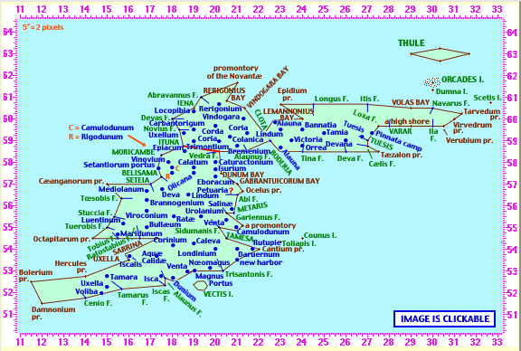
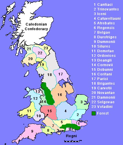
This map is a modern interpretation of the work of Ptolemy's Geographica which shows the approximate location of the Celtic Tribes after the Roman conquest of 54AD.

Two major forest are shown, Anderida in the south and a second along the welsh border, the existence and spread of these is derived from the location of Saxon villages containing 'hurst' which appears to mean forest clearing - see our Anderida Forest Map.

You will also notice that the map shows the 4 metre high tide levels which influences the coast mostly in Sussex, Kent, Essex, Norfolk and the Wash. The shape of Britain in todays maps has been massively influenced by drainage of marshlands and provision of sea defences. The Wash was a tidal basin and the Romney marsh was predominantly tidal mud flats but other areas especially around Kent, Essex and the Humber have had major changes. Many thanks to firetree.net for their wonderful website showing sea level effects on the coastline - link is below.
 

The original Ptolemy map and descriptive text covers the known Roman world in about AD140 a snapshot image link to the British section on a much more complete interactive site by Bill Thayer is shown below, please click on the image to be taken to Bill's site.
Ptolemy Albion - map of Britain AD140

External References in no particular order :-
Anglo Saxon Chronicles
Online Anglo Saxon dictionary
Online Etymology dictionary
Open Domesday Book - The first free online copy of the Domesday Book
The Ermine Street Guard Roman re-enactment and research Society
The "Kent A" cadastre - page 5 - Peterson 2002
Archaeologia Cantiana Online
Romney Marsh Research Trust
Romney Marsh the Fifth Continent
VillageNet the reference guide to villages in Kent & Sussex
Global warming Flood Maps
The Anglo Saxon Chronicles
Google Maps - the core of the system
GeoPlaner - Useful site for plotting map data
Julius Caesar's Gallic Wars 55BC(Books 4 & 5)
Wikipedia - Caesar's invasions of Britain
Wikipedia - Portus Istus
The Geography of Claudius Ptolemy (Bill Thayers)
Roman Britain.org
Runetree Beowulf
Bayeux Tapestry Online
The Secrets of the Norman Invasion
Chronicles of John of Worcester
Battle Historic Society
Binsted village website(Mearcredesburnan Steðe)
The Spears of Andred
Find British Archaelogical Sites
Wealden Iron Research Group
Topographic Map of the UK
1
 

Copyright saxonhistory.co.uk 2013 - 2024
Contact Simon
Author Simon M - Last updated - 22/06/2017 06:54
All pages on our site (Sitemap)