| The Saxon Kingdom of the Haestingas |
|---|
| |
|---|
The Haestingas a logic puzzle |
|---|
|
The Kingdom of the Haestingas is one of the least documented Saxon kingdoms in
England, yet the evidence for its existence, its boundaries, and its importance is
hiding in plain sight — in place names, in the Anglo Saxon Chronicles, in Domesday,
and in the landscape itself. This page works through that evidence systematically,
treating it as a logic puzzle: starting with what we know for certain and deducing
what we can from there.
What do we know about them and what can we deduce ?
All maps shown in this presentation have been derived from Google Maps (My Maps)
| | |
|---|
What do we actually know ? ▲ |
|---|
- 771AD the chronicler Simeon of Durham records the defeat of the gens Hestingorum (the people of Hastings) by King Offa of Mercia
- Alfred the Great had a mint and a Burh(Large Fort) at Hastings
| | |
|---|
What else do we know that might have relevance ? ▲ |
|---|
- The area around Hastings has village names that are of Saxon origin.
- Anglo Saxon Chronicles - 892AD - The Great Oak Forest of Andredsweald was in the Hastings area.
- The coastline was much different to today due to erosion and high tide level changes.
The Variable Ocean: Was the high tide level in Saxon times at Pevensey at about 4.5 metres ?
- The Romans had industrialised the area to produce iron and ships.
Roman Ironworking in the weald and why it declined
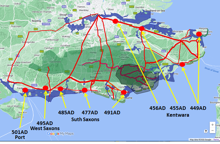
- The Jutes and Saxons appear to have settled westwards from Kent along the south coast according to the Anglo Saxon Chronicles.
- 449AD Henghest and Horsa(Jutes) arrived in Kent to help Wurtgern(Vortigern).
- 457AD Henghest and Horsa(Jutes) controlled all of Kent
- 477AD Aelle landed at Cymensora(Shoreham)
- 491AD Aelle and Cissa(Saxons) besieged Anderida , near Pevensey.
- 495AD Cerdic and Cynric land at a place that is called Cerdic's-ore (Ichenore).
- 501AD Port and his two sons, Beda and Mela, landed at Portsmouth.
- 514AD The West-Saxons landed at the place that is called Cerdic's-ore.(Ichenore)
- 692AD Nothhelm, king of Sussex, grants to his sister Nothgyth, 33 hides at Lidsey, Aldingbourne, Lenstedegate and Mundham Sussex to found a minster, this is signed by two kings, Nothhelm of the South Saxons and Watta possibly of Hastings.
-
771AD Abbot Sibald died; and Egric and Lector' passed
from the course of this transitory life to the fellowship of the elect,
where he takes up an endless song of triumph. At this time Offa,
king of the Mercians, subdued by arms the people of the Hestingi.
| | |
|---|
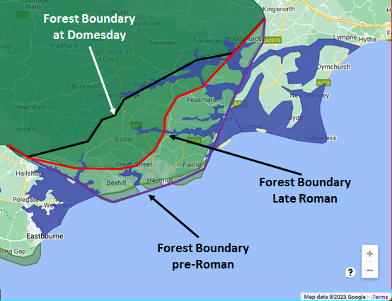
Details of the Coastline at the time ▲ |
|---|
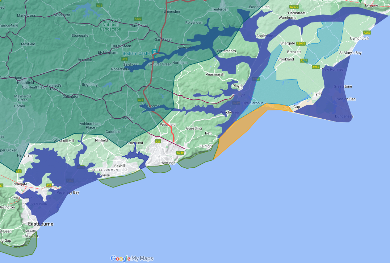
The green shaded area is the Great Forest of Anderida, the coastline shows variations due to high tide level changes and the Rother reaching the sea at Hythe. The eroded cliffs are now shown about 1Km further into the English Channel. Known Roman influences are shown as blue markers, with Bodiam as a major Roman Port.
Known Roman roads and ridgeways are shown going through the Forest. The main Roman iron production from the weald was stopped after Carausius’s revolt in AD286 (Carausius controlled the Channel Fleet and also the main iron production area in the Roman Empire), with the victorious Constantius just leaving enough iron production to continue making nails for shipbuilding.
| When was the Kingdom Settled? ▲ |
|---|
|
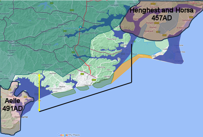
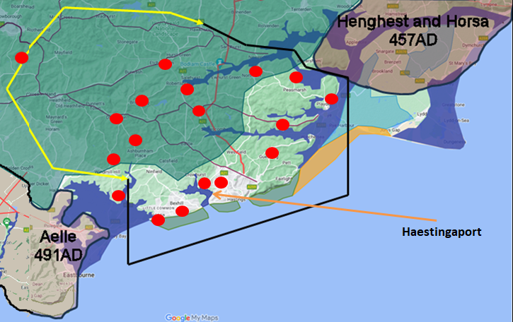
The landings recorded in the Chronicles start in Kent and move steadily westward
along the South coast, each group of incomers occupying territory beyond the last.
Henghest and Horsa take Kent by 457AD. Ælle lands at Shoreham in 477AD and pushes
west to Chichester and east to Pevensey by 491AD. The Haestingas territory — East
Sussex between Pevensey and Rye — sits squarely between these two movements and is
conspicuously absent from the Chronicles.
Nobody records conquering it because by the time Ælle arrived it was already Saxon. The kingdom was most likely settled in the period between 457AD and 477AD, probably toward the earlier end of that window, since
an established kingdom with a defensive perimeter and a working port would have needed time to take shape before Ælle appeared on its western doorstep.
| 
| | |
|---|
The Coastline overlayed with other Settlers ▲ |
|---|
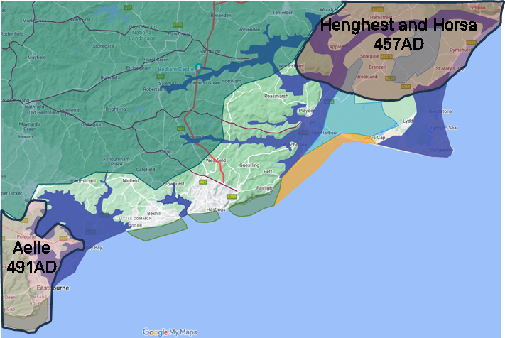
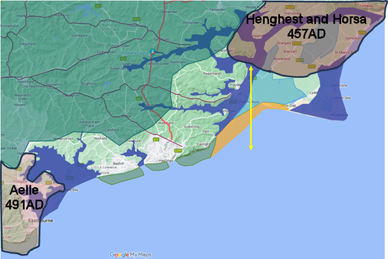
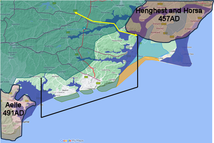
From the Anglo Saxon Chronicles we know that Henghest and Horsa take Kent in 457AD and Aelle takes Pevensey in 491AD, this is shown on the map above, with the rest of the Saxons landing West of Aelle.
The area in between is the Haestingas, and was either settled by Saxons after 457AD, or was still held by the Romano-British for shipbuilding.
| Where was the Kingdom? – The South Eastern Boundary ▲ |
|---|
A.D. 771. At this time Offa, king of the Mercians, subdued by arms the people of the Hestingi. (Symeon of Durham)
A.D. 796. Cynewulf, King of Mercia, made inroads upon the inhabitants of Kent as far as the marsh; and the Mercians seized Edbert Pryn, their king, led him bound into Mercia, and suffered men to pick out his eyes, and cut off his hands.(Anglo Saxon Chronicles)
The Chronicles appear to show the Eastern boundary of the Haestingas does not include the Romney Marsh or the marsh wouldn’t have been included in the Kent victory, so lets assume Rye or less likely the Isle of Oxney as it is included in modern Kent.
The original name for Rye was the Saxon ytera æg meaning the outer island, presumably that of the Kingdom of the Haestingas.
The eastern boundary of modern Sussex also stops around Rye implying that the old boundary was also in this area.
Conclusion:
The South Eastern boundary of the Kingdom of the Haestingas is likely to be the old port of Rye.
| 
| | |
|---|
Where was the Kingdom? – The South Western Boundary ▲ |
|---|
477AD Aelle came to Britain with his three sons Cymen, Wlenca and Cissa with three ships landing at the place called Cymensora(Shoreham). There he killed many Welsh and drove some in flight into the forest of Andredsweald.
485AD Here Aelle defeated the 'Welsh' near Mearcredesburnan stede(Binstead – West Sussex).
491AD Aelle and Cissa besieged Anderida , near Pevensey, and killed all who were inside, so there was not one Briton left.
Aelle landed at Shoreham then headed west to finally capture Chichester, then heads back to the East and has taken the castle at Pevensey in 491AD thereby owning all the land between Roman Chichester and Pevensey Castle. There is no more mention of any other battles or Aelle expansion to the East therefore the boundary must be to the East of Pevensey Castle.
Conclusion:
The South Western boundary of the Kingdom of Haestings is likely to be to the East of Pevensey on the Hooe peninsular.
| 
| | |
|---|
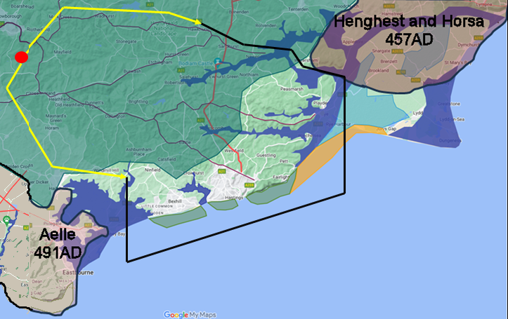
Where was the Kingdom? – The North Eastern Boundary ▲ |
|---|
Hengest owns Kent, and the Roman fortress at Port Lympne and as far east as the Isle of Oxney.
The river Limen/Rother currently reaching the sea at Rye was at the time of the Jute/Saxon invasion reaching the sea at Hythe, so the seaward end of the Rother is controlled by Kent.
The Rother valley was supplying the Romans with timber for shipbuilding and iron for ship nails and weapons.
It is therefore likely that the Jutes took over Oxney and took over the Roman shipbuilding there and probably further up the Rother on the North side near to Newenden where the boundary would then follow the ridgeway towards Hawhurst. It would seem likely that the modern County Boundary was moved to the Kent Ditch area sometime after the landing of the Haestingas.
The Rother would provide a good defensive boundary between the Haestingas and the Kentwara (people of Kent). The village names north of the rother include the ‘den’s which appears to be a Kentish name snippet, the only one south of the river is Playden.
Conclusion:
The North Eastern boundary of the Kingdom of Haestings is likely to be on the Rother near Northiam, which is also the modern boundary between Kent and Sussex.
| 
| | |
|---|
Where was the Kingdom? – The North Western Boundary ▲ |
|---|
This is a much more complex issue as we have no direct evidence for this apart from the Sussex County Boundary, the Roman roads and a stream crossing near Hadlow Down called Hastingsford.
Tribal boundaries in England were quite often along rivers/streams Hastingsford is on a tributary of the ouse called the Uck (this can be translated from the Saxon as Oak appropriate for the Forest). This stream leads up to Rotherfield which is also the source of the river Rother.
There is an area in Rotherfield called Castle Hill which lies on the boundary between the Uck and the Rother and is also on the strategic joining point of two Ridgeways. Places with snippet names ‘Castle something’ would seem most likely to be old Roman Catellums, watch towers.
The northern boundary probably follows the Sussex border and the ridge from Flimwell through to Mark Cross or Frant.
The logic for the area covered is that the main ridgeways from Hastings merge at Rotherfield where they pass on to Crowborough. This is a good strategic place to stop invaders from the West as it provides a single bottleneck in the Forest. Aelle had taken the whole area South of the Forest so would also have come up the London Lewes Roman road to Crowborough so stopping any westward movement by the Haesingaes.
Conclusion:
The North Western boundary of the Kingdom of Haestings is likely to at Hastingsford near Hadlow Down.
| 
| | |
|---|
Where was the Port of the Haestingas ? ▲ |
|---|
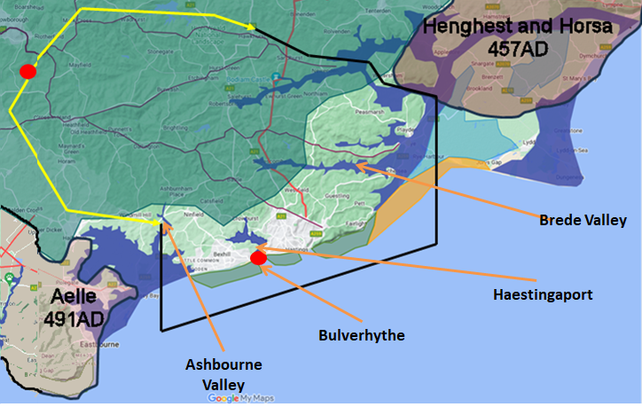
We now have the area of the Kingdom, but the Saxons were seafarers so would need a port for their base, there are only 3 possibilities, the Brede Valley, Combe Haven and the Ashbourne valley as all East and West bound valleys are occupied by Jutes or Britons in very strong Roman forts.
The Ashbourne valley is too near to Pevensey Castle which was occupied at the time by the Britons as Aelle hadn’t taken the fortress at the time. There is also a possibility due to the high tide level changes and the shape of Pevensey Bay that there was a tidal bore at Boreham Street.
The Brede valley would have had limited use as the Romans had denuded the area of any trees which could have been used for houses and shipbuilding and by burning the wood for the production of iron and also the Rother reached the sea at Hythe. The original name for Rye was the Saxon ytera æg meaning the outer island again implying that is wasn’t that close to the Port of Hastings.
This only leaves Combe Haven (translates as a port enclosed by hills ) which would have provided good shelter from the prevailing winds and is right on the edge of Anderida providing copious supplies of wood. Also there is an area at the valley entrance known as Bulverhythe, a hythe seems to have been an important landing place, and Bulver is derived from burgh wara meaning the people(wara) of either the hill(beorg) or fort(burh).
The entrance to Combe Haven is marked by Bulverhythe, which
breaks into bulver (burh wara — the people of the fort)
and hythe (hyð — a significant landing point). A hyð was
not an everyday harbour. Across southern England, hyð names are rare — typically one
per tribal territory — and they consistently appear at coastal or major river locations
that align at the 4.5 metre tidal level.
They appear to mark the original landing
points of Saxon settlement, the place where a tribe first came ashore. If that pattern
holds here, Bulverhythe is not just where the Haestingas kept their boats — it is
where they landed when they first arrived, the founding moment of the kingdom
preserved in the place name.
Conclusion:
The best logic provides a protected sea port in the modern Filsham valley that would have provided a haven for the ships, and was near enough to the Forest and Iron workings to be able to be a shipyard for the Hastings Fleet.
| 
| | |
|---|
The meaning of the name ? ▲ |
|---|
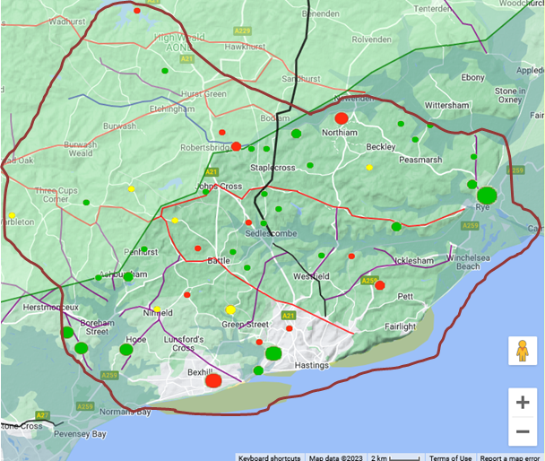
Hastings is a Saxon word, the snippet hast derives from hǽste meaning violent, vehement or impetuous, this could relate to the sea in the area, or could come from a warriors name.
Hence Hǽste ing
Meaning either:
The fort by the violent sea
The fort protected from the violent sea
The fort of hǽste the violent warrior
Conclusion
The Saxon snippet ing derives from nering,
meaning a defended or pallisaded enclosure — in other words, a fort. A pallisaded
village is a fortified settlement, and the distinction between a defended village and
a small fort is largely one of scale. The ing settlements shown on this map
are not simply villages that happen to share a name element — they are fortified
points, each one on a strategic road, ridge or valley approach into the kingdom. The
pattern is too consistent to be coincidence. This was a planned defensive perimeter.
| The economics of the Kingdom of Hastings ▲ |
|---|
For this we need to start with the Romans who had occupied the area since 43AD.
It is very likely that this iron rich area with its vast forest containing oak was the main reason for their invasion.
The following figures come from research by the Wealden Iron Research Group
1st Century iron production was about 420 tons per year from small bloomeries
2nd Century was 630 tons per year as the bloomeries become more industrialised
3rd Century was lower at about 360 tons per year, but this was probably caused by Carausius’s revolt in AD286 reducing production, with Rome finally moving iron production for weapons to other parts of the empire.
4th Century now just a trickle at about 40 tons per year, probably just used for shipbuilding.
After the Romans left there is very little evidence remaining for major iron working in the area until the 1200’sAD (Wealden Iron Research Group)
The Forest of Andredsweald reaching the sea at Pevensey, Crowhurst and the Rother valley contained a great deal of the hardest oak trees in europe, so that shipbuilding by the Romans became important to provide vessels to transport goods to and from mainland Europe, and to build the Roman fighting ships the liburnae to protect these merchantmen.
The defeat of the Carausian revolt in AD296 by Constantinus gave the Romans a choice, either stop iron production or shipbuilding, as a single commander holding both could take control. There were iron reserves in other parts of the empire but no other sources of this very hard oak so the main iron production was moved to a number of other European sites and reduced in this area to a level that was only sufficient for shipbuilding.
This is my conclusion of the late Roman Empire in Britannia, and it would appear to fit the facts, but your ideas may be better so please let me know of any you might have
| 
| | |
|---|
Surrounding Defenses ▲ |
|---|
|
A pallisaded village is a fort. Each of the ing settlements shown on
this map was a defended strongpoint — a pallisaded enclosure on a ridge, road or
valley that controlled movement into and out of the kingdom. Taken together they form
a coherent defensive ring around the Haestingas territory, with concentrations on the
strategic routes most likely to be used by an invader: the ridgeways from the west,
the valley approaches from the north, and the coastal routes from Kent.
This was not an accident of naming. The Haestingas deliberately fortified the
approaches to their kingdom with a network of pallisaded strongpoints, each one
covering a specific chokepoint in the landscape. The same logic appears at
Bulverhythe on the coast — burh wara hyð, the landing place of the people
of the fort. The ing ring around Hastings is the internal equivalent: a kingdom
that had organised its own territorial defence and maintained it for the better part
of 600 years.
| 
| | |
|---|
The Domesday and the Rape of Hastings ▲ |
|---|
A Rape was an area from the Domesday Book, which defined a Lords domain. The word derives from rope and appears as a rough boundary around Hastings, but includes a lot of the area we have previously identified as the Kingdom of Hastings.
The map below shows the Domesday villages and the Forest of Andredsweald and the area of the Rape.
| 
The map below was produced by Thomas Allason in 1819 and shows the Rape of Hastings.
| 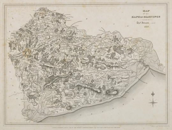
Please click on this image to view a zoomable map from the National Galleries website.
| Other historic details of the area post King Offa and pre Norman ▲ |
|---|
692AD. Nothhelm (Nunna), king of Sussex, grants to his sister Nothgyth, 33 hides (cassati) at Lidsey, Aldingbourne, Lenstedegate (? Westergate in Aldington) and (North) Mundham, Sussex to found a minster, this is signed by two kings Nunna of the South Saxons and Watta possibly of Hastings.
771AD King Offa of Mercia conquered the area.
The area was very isolated with only a few ridgeways or Roman roads leaving to the rest of the country, this means that it is unlikely that Hastings was an import/export port until some time after 1066AD when more of the forest was removed and the land communications links improved. So the only conclusion is that for King Offa to take over this independent area it must have been important for something, even if only for his conquest, but it would also most likely for shipbuilding.
914 AD The Burghal Hideage, Alfred the Great’s list of defensive forts for Wessex
describes a Burh(fort) at Hastings. This was the most Eastward of Alfred’s forts and was designed to prevent the taking over of an area by the Danes/Vikings.(most likely location is Baldslow Down Landscape - Alfred the Greats fort in Hastings)
924 AD King Athelstan had a mint at Hastings.
The two above features imply that Hastings was very important to Wessex, again probably for its shipbuilding.
This raises a question that the standard accounts of 1066 rarely address directly:
why did William choose to land at an isolated Saxon port on the South coast rather
than closer to London? The answer suggested by everything on this page is that
Hastings was not isolated at all — it was one of the principal shipbuilding centres
in Saxon England, with six centuries of continuous tradition behind it, a protected
deep-water haven at Combe Haven, and the last stands of the hardest oak in Europe on
its doorstep. William knew that seizing Hastings would threaten Harold's ability to
maintain and replace his fleet, and that Harold could not afford to let that happen.
The battle was fought where William chose to fight it precisely because Hastings was
too important to abandon.
Battle of Hastings 1066AD - H - Why Hastings?
Further reading on Hastings:
Landscape - Alfred the Greats fort in Hastings
Battle Historical Society on the Rapes of Sussex
|
|
|
;)
)


