| Battle of Hastings 1066AD
Location - 3 Senlac where is it and what does it mean ? |
|---|
|
| | |
|---|
Senlac Hill ▲ |
|---|
We will start with Senlac Hill
| Documentary evidence for Senlac ▲ |
|---|
By looking at the documents available from the time of the Battle, there is only one reference to Senlac which comes from Orderic Vitalis(Gesta Normannorum Ducum) the relevent passage reads :
'The battle commenced at the third hour of the ides [14th] of October, and was fought desperately the whole day, with the loss of many thousand men on both sides. The Norman duke drew up his light troops, consisting of archers and men armed with cross-bows, in the first line ; the infantry in armour formed the second rank ; and in the third were placed the cavalry, in the centre of which the duke stationed himself with the flower of his troops, so as to be able to issue his commands, and give support to every part of the army. On the other side, the English troops, assembled from all parts of the neighbourhood, took post at a place which was anciently called Senlac, many of them personally devoted to the cause of Harold, and all to that of their country, which they were resolved to defend against the foreigners. .'
He doesn't mention any hills, just the word Senlac.
| The Hill from the Bayeux Tapestry ▲ |
|---|
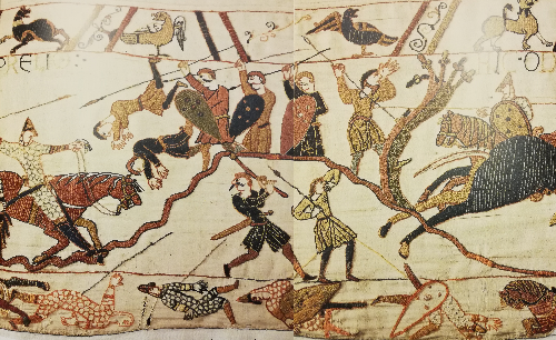
There is no mention of the name Senlac in the Bayeux Tapestry, but a hill is shown.
The ground looks very uneven, either from man made ditches (see our Malfosse page) or just implying broken ground.
| Location of Senlac Hill ▲ |
|---|
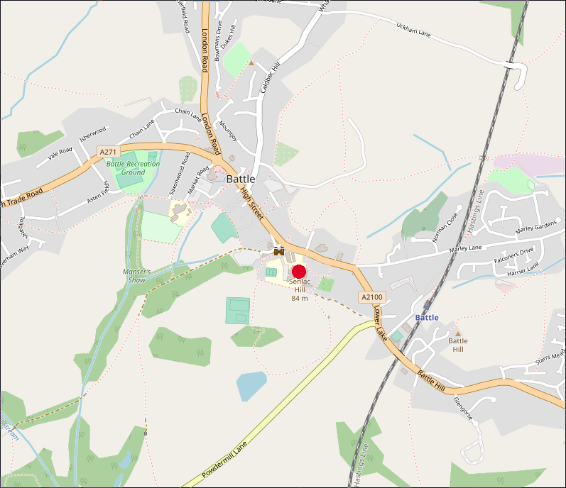 Senlac Hill is found inside Battle Abbey in the small town of Battle in East Sussex and is shown by the red dot on the map below.
| Senlac and the Victorians ▲ |
|---|
The name Senlac was introduced into English history by the Victorian historian E.A. Freeman who suggested that Senlac meant Sand Lake in Old English with the Norman conquerors calling it (in French) Sanguelac('Blood lake').
| Possible Saxon derivations of Senlac ▲ |
|---|
The Victorians were looking at the name with limited data and there are other Saxon words this could be derived from so lets look at these possible versions.
the saxon word lacu can translate to pool, pond or lake
The other naming possibilities are as follows:
segn lacu - this translates to 'Military Banner Lake'
It would seem unlikely that a place was named after a Military Banner unless after the Battle.
segnian lacu - this translates to 'Making the sign of the cross Lake'
It would seem unlikely that a place was named this unless there was a church or monastery nearby and in 1066AD this was empty land.
sand lacu - this translates to 'the Sandy Lake'
To the north of modern Senlac Hill there is a very steep valley with a spring that flows down into the Brede valley, the nearest pond in that direction would have been towards Marley Lane a mile or so away but no reason to call it senlac as marley means marl island(marl meaning clay).
Please be aware that a lot of ponds that are now in the area were caused by doodlebug explosions from World War 2 falling short of London, being shot down or being turned over by typhoon fighters.
It would seem unlikely that a place was called sand lake in an area which is mostly clay.
isen lacu - translates to 'Iron Lake or Iron pond'
To the south there is now the pond created at Powdermills, but originally this may have been created by the Romans digging iron at Peppering eye a few hundred metres to the south east.
To the North West of the Battle Abbey lies the hamlet of Beech(now Beech Farm) which was in the Domesday Book and was an iron working site that made cannons for the Royal Navy in the early 1700's.(please refer to the Wealden Iron Research Group's database )
It would seem quite possible that iron lake is the translation, however it could have been at Pepperingeye near the Abbey, or towards Netherfield at Beech Farm
æscen lacu - translates as 'Ash tree Lake'
To the west towards Ashburnham we have an area known for its ash trees, and near to Ashburnham(Meaning the Stream in the Ash trees)
there are a number of lakes, probably formed again for iron working , so there may be a second Senlac. Please see the map below.
It would seem quite possible that ash tree lake is the translation, however this would mean the Battle was near Netherfield, Ashburnham or Penhurst and not at Battle.
| Possible alternative Saxon locations for Senlac ▲ |
|---|
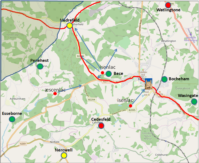
The above map shows possible other Senlac Hills based on the local geography, please take a look at the above details and make your own judgement on the location of the real Senlac.
The larger circles with names show the Domesday settlements in the area, the red lines are ancient Celtic ridgeways that the Romans and Saxons used, the green shaded area shows the Forest of Andredsweald.
The shading of the settlements denotes the damage recorded in the Domesday Book, red denotes wasted, the yellow denotes damaged and green undamaged settlements.
| Conclusions for Senlac ▲ |
|---|
Please Note:
I am not trying to disclaim the current location of Senlac Hill, I am offering other translations which could imply differing locations.
The Battle Abbey Chronicles make no mention of Senlac - that seems odd as its in the current Abbey Grounds.
Orderic Vitalis doesn't mention a hill in relation to the name, just at a place anciently called Senlac, which in turn could imply a general area not a specific place, a bit like 'the Battle of Hastings' not being at Hastings, but in the old Kingdom of Hastings.
| Herst ▲ |
|---|
Now lets look at the place named Herst
| Documentary evidence for Herst ▲ |
|---|
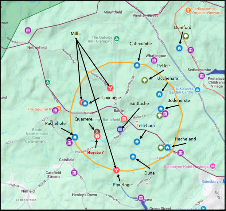
This place is referenced by the Battle Abbey Chronicles and would seem to be near the Quarry to the south east of the Abbey, and a short distance from Powdermills.
|
This map shows the majority of places named in the Leuga of the Abbey as recorded in the Battle Abbey Chronicles
| Conclusion for Herste ▲ |
|---|
Herste is mentioned by the Monks of Battle Abbey as their preferential location for the siting of Battle Abbey, but William instructed them to build the Abbey where Harold died see Battle of Hastings 1066AD Location - 1 the Lands of Battle Abbey from the Abbey Chronicles for an analysis of the nearby locations.
| Conclusion ▲ |
|---|
Conclusions for Senlac
The name Senlac appears in only one source — the Gesta Normannorum Ducum of Orderic Vitalis — and in that single reference he describes it as a place, not a hill. The Battle Abbey Chronicles, written by the monks on the very site claimed to be Senlac Hill, never use the name at all — which is remarkable if it referred to the ground immediately outside their walls. The Victorian rendering of the name as "sand lake" or "blood lake" was speculation with limited linguistic foundation, and the alternative translations — iron lake, ash tree lake — point to locations away from the Abbey entirely.
The isenlacu translation has the strongest local evidence. Iron workings at Beech Farm to the west, Roman iron extraction at Pepperingeye to the southeast, and the Powdermills pond all support a landscape associated with iron and water in that area. The name Beech appears in the Domesday Book as a working settlement, and the B2096 through Netherfield is recorded as Kame Hythe Road — cyne hyð rad in Saxon, meaning the starting point of the King. That is a striking piece of nomenclature to find on the road through the area most consistent with the isenlacu translation.
The conclusion that Senlac Hill is the hill within Battle Abbey grounds rests on tradition and on the Abbey Chronicle, not on independent documentary evidence.
Overall Conclusion
The two place names most often used to anchor the Battle of Hastings to its traditional location — Senlac and Hecheland — both derive from the same narrow body of evidence. Senlac appears in one chronicle version only, without the word hill, and the Abbey's own monks never used it. Hecheland appears in the Abbey Chronicle in a context that serves the Abbey's interests precisely, and the approach route it implies is geographically incoherent.
This does not prove the battle was elsewhere. It does mean that the traditional location rests on weaker documentary foundations than is commonly assumed, and that the Abbey Chronicle should be treated as an interested party rather than a neutral source. The monks built on a hill twenty years after the battle, with most participants dead, on ground well suited to a monastic community — high, watered, beside the main road north.
The incentive to claim the battle site was substantial. The pilgrim traffic it would generate was the medieval equivalent of a permanent income stream.
The alternative translations of Senlac, the Kame Hythe Road nomenclature, and the logical approach route from Cooden through Ninfield all point consistently toward the Netherfield area. That case is examined in detail in Pages S and S2.
|
|
|
|
;)


