| The Variable Ocean: Was the high tide level in Saxon times at Pevensey at about 4.5 metres ? |
|---|
| |
|---|
Table of Contents |
|---|
| | |
|---|
A logical discussion of why the high tide level in early Anglo Saxon times was about 4 to 5 metres ▲ |
|---|
This page is designed to show why I believe that the high tide level was at about the 4 to 5 metres mark in about 450AD (early Anglo Saxon times)
Lets take an area I know - the Pevensey Levels in Sussex - click here if you would like to see a similar argument applied to the Wash.
So we will start by looking at the Saxon place names which refer to islands these places are all derived from the Saxon word æg meaning an island, which has been shown to refer to modern place names starting in eg, ending in ay, et, ey, ly, ney, sea, sey, ye , is, or contain the snippet eye or island.
So lets take a look at modern Pevensey and see if we can make it and the surrounding island villages into islands by raising the sea level a metre a time to simulate high tide levels. The following images are derived from Open Streetmap with the sea level overlays provided by Alex Tingle from http://flood.firetree.net.
The high tide level at Pevensey in about 450AD was approximately 4 to 5 metres higher than it is today. This page sets out the evidence for that claim using Saxon place names, flood modelling, and recent geological research.
The starting point is Saxon place names that refer to islands. These derive from the Old English word æg, meaning an island, and survive today in modern names ending in -ey, -ney, -sea, -sey, -ye, or containing the elements eye or island. If these places were genuinely islands, the surrounding water must have been high enough to cut them off — and the flood maps below show what sea level would need to be to achieve that.
| | |
|---|
This map shows the current sea level ▲ |
|---|
This map is derived from flood.firetree.net and shows the current high tide levels in the Pevensey bay in East Sussex, England.
| | |
|---|
This map shows the sea level raised by 1 metre to simulate higher tides ▲ |
|---|
This map is derived from flood.firetree.net and shows the effect of a 1 metre rise in tidal levels in the Pevensey bay in East Sussex, England.
| | |
|---|
This map shows the sea level raised by 2 metre to simulate higher tides ▲ |
|---|
This map is derived from flood.firetree.net and shows the effect of a 2 metre rise in tidal levels in the Pevensey bay in East Sussex, England.
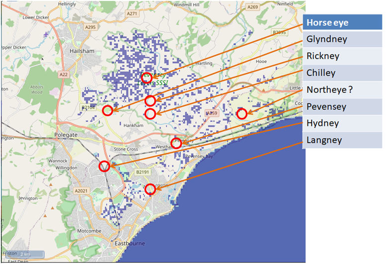
We don't see any islands at the moment, but there are some interesting possible islands, such as horse eye.
| | |
|---|
This map shows the sea level raised by 3 metre to simulate higher tides ▲ |
|---|
This map is derived from flood.firetree.net and shows the effect of a 3 metre rise in tidal levels in the Pevensey bay in East Sussex, England.
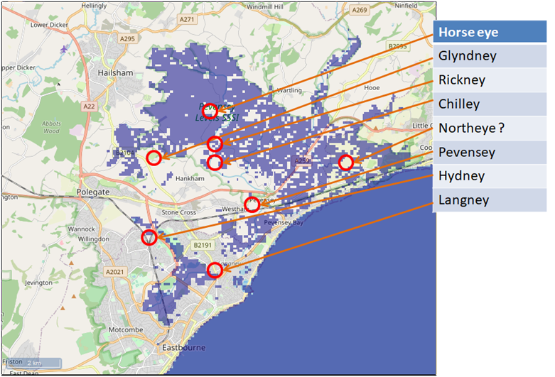
This is starting to get interesting, there are islands appearing, but Rickney and Chilley look underwater, however the resolution of the Nasa Data is not fine enough to show the smaller islands.
| | |
|---|
This map shows the sea level raised by 4 metre to simulate higher tides ▲ |
|---|

This map is derived from flood.firetree.net and shows the effect of a 4 metre rise in high tide levels in the Pevensey bay in East Sussex, England.
Langney is now an island along with Glyndney, so we are getting somewhere, but Pevensey is not quite an island.
| | |
|---|
This map shows the sea level raised by 5 metre to simulate higher tides ▲ |
|---|
This map is derived from flood.firetree.net and shows the effect of a 5 metre rise in tidal levels in the Pevensey bay in East Sussex, England.
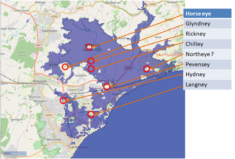
At last Pevensey is an island as are the other settlements ending in æg.
| | |
|---|
Other Evidence ▲ |
|---|
The Pevensey example is not an isolated case. Two further lines of evidence point in the same direction:
Was the high tide in Saxon times 5 metres higher? — the Wash
The same place-name analysis applied to the Wash in East Anglia produces consistent results: settlements with -ey and related endings cluster at elevations that only become islands when the sea level is raised by 4 to 5 metres, matching the Pevensey findings.
Roman locations that have not been identified and roads that just terminate
A number of Roman roads in the south east end abruptly at or near the modern coast, and several known Roman settlements remain unlocated. A significantly higher tidal range would explain both: roads led to coastal ports and harbours that are now submerged or buried under later sediment.
| | |
|---|
Scientific papers that support this concept ▲ |
|---|
A recent scientific paper published in 2026 has provided compelling geological evidence for a major sea-level event in the 5th century, directly corroborating the theory developed on this site from place-name and topographic analysis. This new evidence transforms our understanding from a plausible hypothesis into a well-supported model of rapid coastal change during the Early Anglo-Saxon period.
The Article:
English Coastal Archaeological Evidence of a Fifth-Century (Dark Ages) 4-Meter Sea-Level Rise in 70 Years, Portending a Similar Rise Imminently
Please click on the following link to see the paper from the Journal of Coastal Research if this doesn't work, please copy and paste the following into a browser [ https://jcr.kglmeridian.com/view/journals/coas/42/1/article-p165.xml ] then click the 'Download pdf' button.
Written by Dr Roger Higgs and published online January 2026 in the Journal of Coastal Research.
| Research Findings ▲ |
|---|
1. Introduction: New Scientific Corroboration
A scientific paper above has provided compelling geological evidence for a major sea-level event in the 5th century, directly corroborating the theory developed on this site from place-name and topographic analysis. This new evidence transforms our understanding from a plausible hypothesis into a well-supported model of rapid coastal change during the Early Anglo-Saxon period.
2. Summary of the Key Scientific Finding
A study of coastal archaeological sites across England, including the Roman fort at Pevensey, demonstrates that a rapid relative sea-level rise of approximately 4 meters occurred within roughly 70 years, spanning the period ~430-500 AD (the early "Dark Ages"). This was a major marine transgression that dramatically reshaped the coastline.
3. Connecting the Evidence: Place-Names Meet Geology
The convergence of evidence is striking:
- Geological Proof: At Pevensey Castle, excavations found early-5th-century tidal mud within the defensive ditch at a level over 2 meters higher than the fort's original foundations. This indicates the high-tide water level rose significantly after the fort was built, undermining its walls by the mid-to-late 5th century.
- Historical Geography Explained: This ~4-meter rise is precisely the scale required to transform the settlements with "-ey" (from Old English æg, meaning island) on the Pevensey Levels into true tidal islands. The scientific data confirms the landscape model derived from place-names and flood maps.
4. Broader Historical Implications
This rapid environmental change likely had profound historical consequences. As noted in the research, it may help explain the mass migration of Angles and Saxons to southeastern Britain in the 5th century. Their homelands on the North Sea coastal plains may have become increasingly inundated and uninhabitable, "squeezed" between the encroaching sea and other population pressures.
5. Modern Context and Conclusion
The combination of historical geography (place-names and topography) and modern geological science now presents a coherent and evidence-based picture of a pivotal environmental event at the dawn of English history.
| Conclusion ▲ |
|---|
The place-name evidence, the flood modelling, and the 2026 geological paper by Dr Roger Higgs now converge on the same conclusion: the high-tide mark in early Anglo-Saxon times stood at roughly 4 to 5 metres above its current level. At that height, the æg settlements of the Pevensey Levels — Pevensey, Horseye, Northeye, Langney and the rest — would have been genuine tidal islands, exactly as their names suggest.
It is worth noting that modern sea defences and accumulated shingle banks tend to mask the true relationship between land and water, making it harder to visualise how dramatically the coastal landscape has changed. The maps above, stepping up one metre at a time, are an attempt to make that change visible.
| | |
|---|
Translation of the names on the above maps ▲ |
|---|
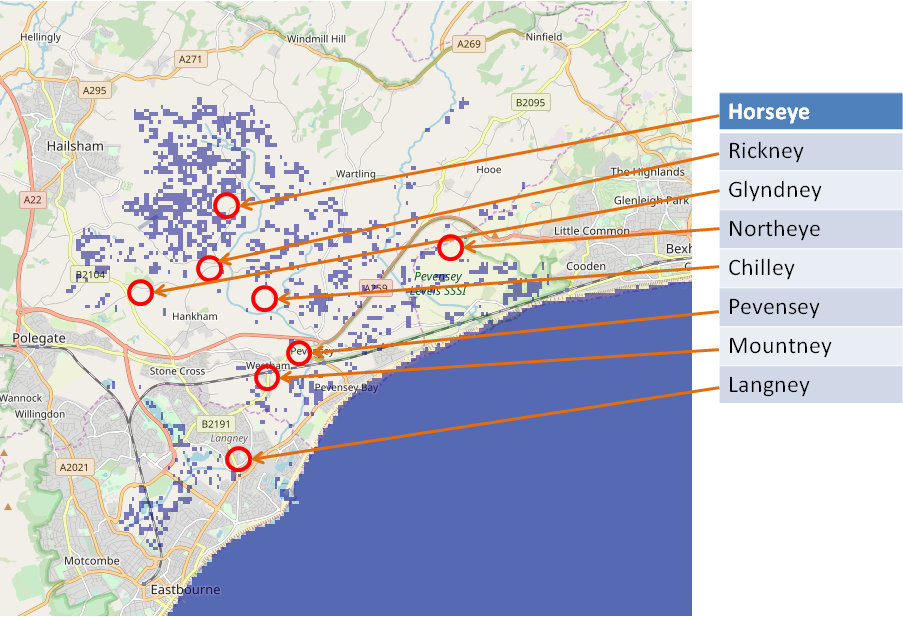
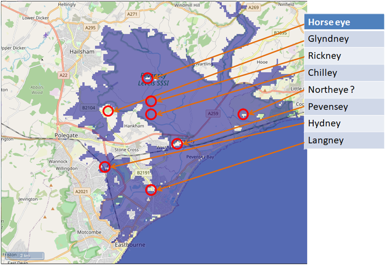
This list shows our current translation of the locations shown on the above maps.
These come from our snippet theory of settlement names which we believe the Saxons and other earlier settlers used to describe the location and or use of the place.
Click here to translate a location
The following list of islands from the maps are all Saxon derived names
- Horseye - horse derived from heors - horse / ye derived from æg - an island
- Rickney - rick derived from rics - the reed / ney derived from en æg - en - 'people of' and æg - 'an island'
- Glyndney - glynd derived from glind - fence of boards or railing / ney derived from en æg - en - 'people of' and æg - 'an island'
- Northeye -north derived from norþ - north / eye derived from æg - an island
- Chilley -chil derived from ceorl - a freeman / ley derived from el æg - person's island
- Pevensey -pevens derived from fæsten naess - fortress promontory / ey derived from æg - an island
- Mountney - mount derived from munt - a mountain or mound / ney derived from en æg - en - 'people of' and æg - 'an island'
- Langney -lang derived from læng - long / ney derived from en æg - en - 'people of' and æg - 'an island'
| | |
|---|
Links to other Documents ▲ |
|---|
|
| | |
|---|
Links to other Documents ▲ |
|---|
|
The pages below show links to documents that reference pages concerning The Variable Ocean.
These pages discuss the apparent historical Sea Level changes that have been found across the UK, their implications and the creation of a theory of Sea Level changes that incorporates these observations.
For the individual pages please click on the links, new documents will be auto populated as and when these
are written.
| |
|
|
;)


