| Anglo Saxon Chronicles - 892AD - The Great Oak Forest of Andredsweald |
|---|
|
The Weald of Kent and Sussex is still heavily wooded in places, but in Roman and early Saxon times it was something altogether more formidable — a vast, largely impenetrable oak forest stretching roughly 120 miles east to west and 30 miles north to south. The Romans called it Silva Anderida. The Saxons called it Andredsweald or Andredsleage. Both names point to the same landscape: an enormous barrier of ancient woodland that shaped the settlement, industry, and military history of south-east England for centuries.
This page traces the extent of that forest using place-name evidence, Domesday records, geology, and the Anglo Saxon Chronicles — and argues that its boundary can be mapped with reasonable confidence, and that it was significantly larger in Roman times than even the Domesday evidence suggests.
| Starting point - investigating the hurst snippet ▲ |
|---|
The current translation of 'hurst' derives from the Saxon 'hyrst' which when looked up in the Anglo Saxon Dictionary is translated as 'A hurst, copse, wood'.
The starting point for this was to investigate the villages/towns that contained the snippet 'hurst', to try to see what this could mean, if anything.
Normally I would plot these locations onto a Google map to see if there is any obvious logic to these places, and so carried this out.
The map shown below takes the place names from the free O.S. map data containing about 250,000 places in the U.K. and plotted all the places containing hurst against their physical locations on a Google relief map.
Please Note:
All the maps shown on this page are derived from Google Maps.
The Domesday plots are derived from the Open Domesday website.
The modern places are derived from the publicly available Ordnance Survey Data.
| Plot of Hursts across the UK ▲ |
|---|
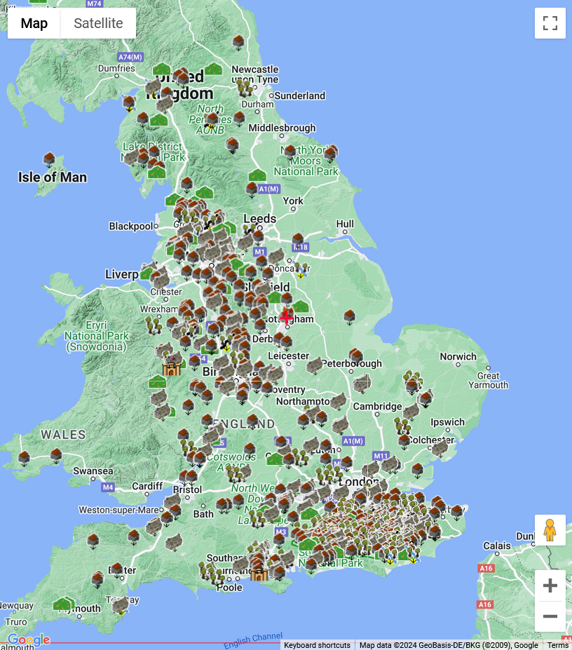
As you can see there appear to be two clusters of places containing the snippet 'hurst' one in the South East of England, and the other between Nottingham and Liverpool.
| | |
|---|
My Area - Battle in East Sussex ▲ |
|---|
I live in a small town called Battle in East Sussex, where the 'Battle of Hastings' is claimed to have occurred, so i will look at my area in a bit more detail.
| | |
|---|
Close up view of the South East of England ▲ |
|---|
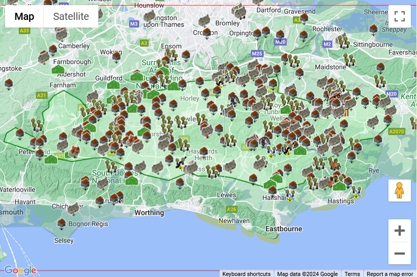
As you can see, the majority of these 'hurst's' lie within an area I have marked with a green border.
This is an interesting shape, do we have any other historic information we can use, so lets see if we can plot the Domesday villages to see if that explains anything.
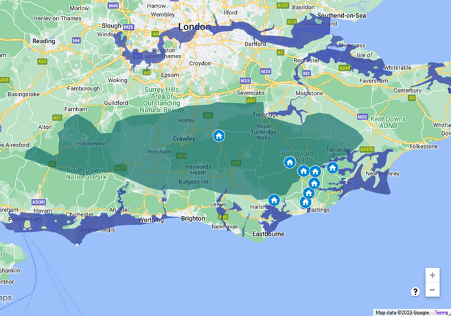
| South East of England at Domesday 1086AD ▲ |
|---|
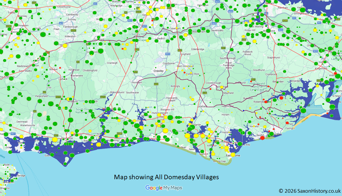
This plot shows all the villages at Domesday and shows an empty area in the center of the image with very few villages and these are small.
The size of each dot shows the relative size of the population at Domesday, so for Example Domesday Rye had a population of 187(large green dot) whereas Brightling in the Forest area has 12(small yellow dot).
The Green dots show villages that did not have any damage done by the Norman invasion, the yellow dots show damaged settlements, and the red ones show settlements that were completely destroyed in 1066AD.
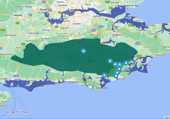
| South East of England at Domesday 1086AD with boundary ▲ |
|---|
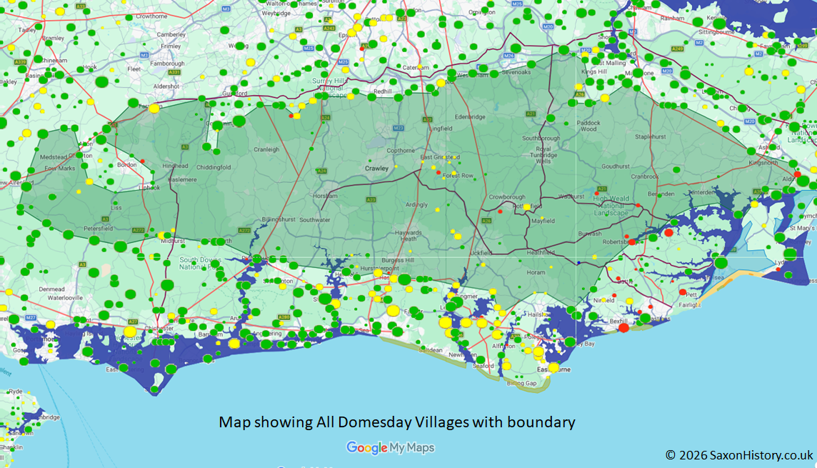
This plot shows all the villages at Domesday and has a boundary marked at the larger villages along what appears to be a boundary.
The size of each dot shows the relative size of the population at Domesday, so for Example Domesday Rye had a population of 187(large green dot) whereas Brightling in the Forest area has 12(small yellow dot).
The Green dots show villages that did not have any damage done by the Norman invasion, the yellow dots show damaged settlements, and the red ones show settlements that were completely destroyed in 1066AD.
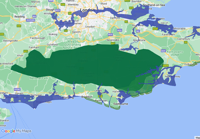
| Woodland at Domesday 1086AD ▲ |
|---|
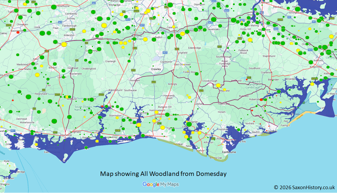
To show this boundary is probably correct, if you plot the settlements recorded as having woodland in 1086AD, you see the map above.
This plot shows all the entries for those villages marked as having woodland in Domesday and shows an empty area in the center of the image with very few villages and these are small, very similar to the above image.
The size of each dot shows the relative size of the woodland at Domesday, the colours are as above .
| Woodland at Domesday 1086AD plus boundary ▲ |
|---|
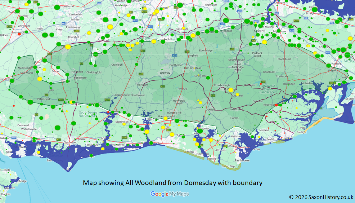
This plot shows all the entries for those villages marked as having woodland in Domesday and shows an empty area in the center of the image with very few villages and these are small, very similar to the above image.
The size of each dot shows the relative size of the woodland at Domesday, the colours are as above .
The shaded area in the center is the same as the All Domesday villages, so it looks like a lot of these locations were on the edge of the Forest, and had areas usually used for pigs to forage.
| I had heard there was a large forest in the area ▲ |
|---|
|
The place-name and Domesday evidence points to a large empty area in the centre of the South East. To see whether this matches any known historical record, the obvious next step is the Anglo Saxon Chronicles.
| | |
|---|
The Great Oak Forest of Andredsweald ▲ |
|---|
The Weald is well documented, and the Wikipedia summary gives a useful starting point for its geography:
Quote from Wikipedia
The Weald (/ˈwiːld/) is an area of South East England between the parallel chalk escarpments of the North and the South Downs. It crosses the counties of Hampshire, Surrey, West Sussex, East Sussex, and Kent. It has three separate parts: the sandstone "High Weald" in the centre; the clay "Low Weald" periphery; and the Greensand Ridge, which stretches around the north and west of the Weald and includes its highest points. The Weald once was covered with forest, and its name, Old English in origin, signifies "woodland". The term is still used today, as scattered farms and villages sometimes refer to the Weald in their names.
|
These are the relevant extracts from the Anglo Saxon Chronicles
AD477. This year Aelle, and his three sons, Cymen, and Wlencing, and Cissa, came to the land of Britain with three ships, at a place which is named Cymenes-ora, and there slew many Welsh, and some they drove in flight into the wood that is named Andreds-lea.
755AD This year Cynewulf, with the consent of the West-Saxon council, deprived Sebright, his relative, for unrighteous deeds, of his kingdom except for Hampshire; which he retained, until he slew the alderman who remained the longest with him. Then Cynewulf drove him to the forest of Andred, where he remained, until a swain stabbed him at Pryfetesflodan( fleet), and revenged the alderman,
Cumbra.
AD 892/3. This year went the large army, that we before spoke about, came from a kingdom in the east, westward to Bologne; and there were shipped; so that they transported themselves over at one time with their horses withal. And they came up with two hundred and fifty ships into the mouth of the Limne, which is in East-Kent, at the east end of the vast wood that we call Andred. This wood is in length, east and west, one hundred and twenty miles, or longer, and thirty miles broad. The river that we before spoke about comes out of the weald. On this river they towed up their ships as far as the weald(wood). Four miles from the mouth of the river they destroyed a fort within the fen(possibly Burmarsh - Burh Maersc the marsh fort), whereon sat a few churls, and which was hastily wrought. Soon after this came Hasten up with eighty ships into the mouth of the Thames, and wrought him there a work at Milton. and the other army went to Appledore.
So we have a large forest 120 miles long by 30 miles wide covering the area.
It so happens that the green shaded area on our map is about 95 miles long and about 25 miles wide, so is very close to the recorded size of Andredsweald. We also have to acknowledge that the measurements at the time would not be as accurate as modern times.
This implies that a settlement name that includes 'hurst' means 'a clearing in the Forest' and not a wood or copse..
| The Geology of the area ▲ |
|---|
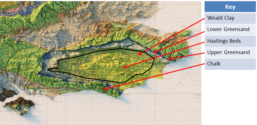
The Iron rich soils of the Hastings Beds provides very good Oak and forest growing land and the Forest shape shown in black from the Domesday boundary plot seems to reflect the geology of the area.
As you can see the area around Hastings is also covered by the Hastings beds, so it can be assumed that originally the Forest reached the sea in this area, pre Roman.
It is possible that the original Forest filled the area up to the Upper Greensand boundary.
Let us now plot the settlements containing 'hurst'.
| Domesday Hurst ▲ |
|---|
This plot shows just the villages containing the snippet 'hurst' at Domesday.
As you can see there are very few and these are mostly near Pevensey and Hastings which is odd.
| History and Assumptions ▲ |
|---|
So why are there a few Hursts in Domesday around Hastings?
Perhaps the forest was bigger and that the hursts at Domesday were originally in the Forest.
We now need to make a few assumptions:
- Hurst means ‘a clearing in the Forest’
- The Saxons settled in the Hastings area around 460AD (as the majority of village names in the area are of Saxon origin)
- The hursts recorded in Domesday were settled in early Saxon times.
- The Romans were extracting iron and making ships from the wood in the forest.
- The foundations of the Roman fort of Anderida(Pevensey) used oak and we have calculated that a square km of forest would be needed to provide the oak required.
- The Romans and Saxons built their ships from oak.
- The high tide level was approx 4.5 metres higher in Roman times.
- The Saxons continued the Roman ship building in the Hastings area.
- The time between the early Saxon times of about 460AD to the Domesday book of 1086AD are 626 years.
If the above is true then the rate of Forest removal of the Forest in the Hastings area was significantly higher than other areas in Kent and Sussex, or there would have more hursts recorded in Domesday in other areas.
So if the Forest is being felled continuously for 650 years to smelt iron and build ships then this would make the area of Forest removed quite significant and make the Forest much larger in Roman times.
| Forest expanded to include the Hursts at Domesday ▲ |
|---|
This plot shows just the villages containing the snippet 'hurst' at Domesday.
If we now enclose the areas of the Domesday hursts within the Forest then we now show the approximate Forest boundary about 460AD when the Saxons settled, and at this time it was known by its Roman name of Silva-Anderida ( this could be translated from the Latin to mean the ‘entry point to the Forest’ ).
Pevensey Castle was known as Anderida (possibly ‘the entry point’) by the Romans.
| Hursts prior to the Roman Invasion ▲ |
|---|
This plot shows the extent of the Forest before the Romans and Saxons started removing the oak for shipbuilding and iron smelting.
| The Romans called the forest Silva Anderida ▲ |
|---|
The Romans called the Forest 'Silva Anderida'.
From the Latin 'Silva' translates as 'the forest', 'Anderi' means 'to enter' and 'da' means 'give'.
So Anderida means 'to give entrance' or 'The entrance' and Silva means 'the Forest', so the Roman fort at Pevensey(Anderida) meant 'to give entrance', and 'Silva Anderida' means 'the entrance to the Forest'.
| Roman traces in the Area ▲ |
|---|
The Forest was being felled for fuel for the bloomeries and timber for shipbuilding, which would take place near the rivers and estuaries as these would provide easy routes to transport iron and oak from the area.
The sea would have reached the forest at Ashburnham behind the fort of Anderida, it would also have reached the sea in the Filsham valley at Hastings, the river Limen(Rother) and finally the Brede valley so this is where the main extraction would take place.
The major Roman ironworks were in the Brede valley so that area would be using the timber for fuel, and not for shipbuilding.
The Rother valley being quite long would have been used for ironworking at Bardown near Stonegate, and shipbuilding near Bodiam.
This would leave the Pevensey area as the major shipbuilding area, with the Filsham valley as a secondary site.
| The impenetrable forest ▲ |
|---|
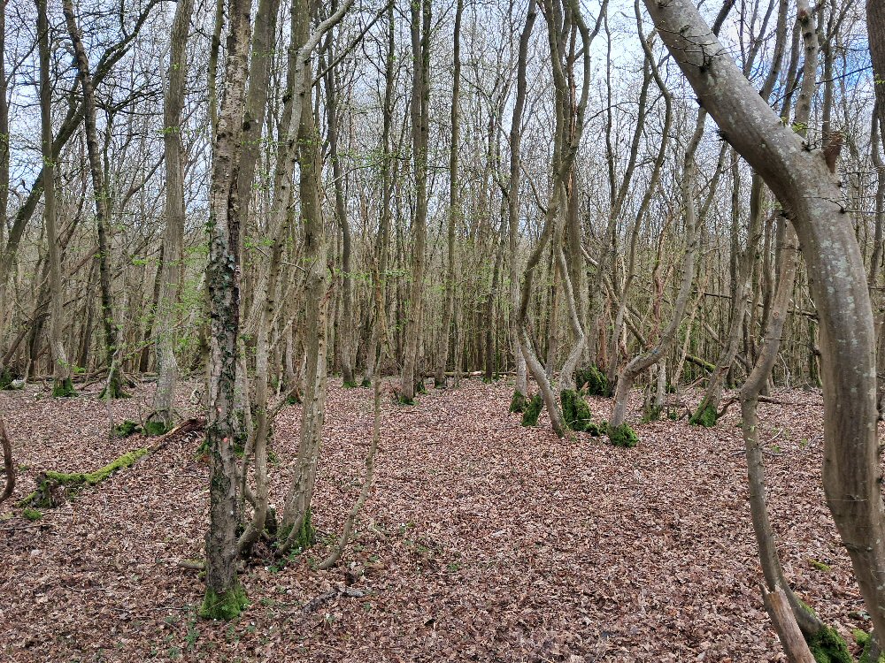 The image to the left shows the current woodland around the Battle area, and shows how dense the trees are, this would make it very difficult to take horses through the forest.
The Forest was looked on as being impassible except where the old Ridgeway's or Roman roads passed through, unless you lived in the Forest.
This would have made it very difficult to leave the area by road, and by the same token, the local forest would provide excellent timber to build ships, to sail away from the area.
| | |
|---|
Conclusion ▲ |
|---|
The evidence from place names, Domesday records, geology, and the Anglo Saxon Chronicles converges on the same picture. The great Forest of Andredsweald occupied the area bounded by the Domesday village distribution — a roughly oval region about 95 miles long and 25 miles wide, closely matching the 120 by 30 miles recorded in the Chronicles, allowing for the imprecision of early medieval measurement.
The Romans began felling the forest systematically — for charcoal to fuel the Wealden iron bloomeries, and for oak timber to build ships. The concentration of Roman ironworks in the Brede valley and the evidence for shipbuilding near Pevensey suggest that the coastal estuaries, which at a tidal level 4.5 metres higher than today would have reached deep into the forest, were the main arteries for extracting both iron and timber.
The Saxons who settled the Hastings area from around 460AD continued this work. The hurst place names — clearings in the forest — cluster around Hastings and Pevensey precisely because that is where the felling was most intensive. Six hundred years of continuous clearance for iron smelting and shipbuilding explains why so few hursts appear in the Domesday record further into the forest: the forest there was still largely intact in 1086AD.
The location of Pevensey Castle (Anderida — 'the entrance') takes on a new significance in this context. When Boulogne fell to Carausius in 293AD, the Roman fleet needed a new base. The major oak shipyards were here, the tidal estuary reached into the forest behind the fort, and the fort itself guarded the entrance to both the bay and the woodland beyond. It is a reasonable inference that Anderida became the principal base of the Classis Britannica not despite its location at the edge of a great forest, but because of it.
Shipbuilding in the area continued long after the Romans and Saxons — records show it persisting in the Rother valley into at least the 1600s. The forest that shaped a Roman fleet base, sheltered Saxon fugitives, and frustrated Norman cavalry was not finally tamed until the demands of the iron industry and the Royal Navy had consumed the last of it.
| | |
|---|
Recommended Reading ▲ |
|---|
|
|
|
;)
)
)
)
)
)
)