|
The Variable Ocean: Was the high tide level in Saxon times in the Wash 4 to 5 metres higher ? |
|---|
| |
|---|
Table of Contents |
|---|
|
| |
|---|
Was the high tide level in Anglo Saxon times higher than today ▲ |
|---|
This page is designed to show why I believe that the high tide level was 4 to 5 metres higher than today, in about 450AD (early Anglo Saxon times)
So we will start by looking at the Saxon place names which refer to islands these places are all derived from the Saxon word æg meaning an island, which has been shown to refer to modern place names starting in eg, ending in ay, et, ey, ly, ney, sea, sey, ye , is, or contain the snippet eye or island.
So lets take a look at the Wash in Eastern England and see if we can make it and the surrounding island villages into islands by raising the high tide level. The following images are derived from Open Streetmap with the high tide level overlays provided by Alex Tingle from http://flood.firetree.net.
|
| |
|---|
The Wash in Eastern England ▲ |
|---|
The Wash is an area I don't know as well as Sussex, so it makes a useful independent test — if the same place-name argument holds here, that adds considerably to its credibility. Click here if you would like to see the original argument applied to the Pevensey Levels in Sussex.
The 'Time Team' carried out a dig at Bawsey St Peter in Norfolk and found a causeway leading to what was clearly once an island. The Saxon name Bawsey means either 'Pasture Island' or 'Boar's Island' — further evidence that the 5-metre mark is valid.
Ivan D Margary plotted Roman Road M27 — Lincoln to Burgh le Marsh — which terminates at Burgh le Marsh. At a high tide level of +5 metres, that terminus would sit directly on the Saxon-era coastline, which neatly explains why the road ends where it does.
The flood maps below are derived from OpenStreetMap with sea level overlays by Alex Tingle at flood.firetree.net. Each map can be clicked to open the interactive version.
|
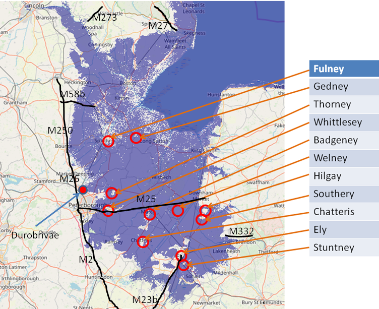
This map shows the current sea level ▲ |
|---|
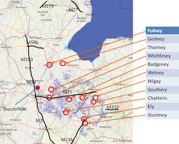
So even at the present day there is land deep in the fens where the land lies below high tide level.
On this map I also show Roman Roads from Ivan D Margary's book 'RomanRoads in Britain' that touch or go near the Wash.
I have also marked the Roman town of Durobrivae as I believe this may be important, and show some Roman roads that are close to the fens.
M250 Bourne to Sleaford
M26 Chesterton to Ancaster via Bourne(King Street)
M2 Chesterton to Lincoln(Ermine Street)
M25 Upton to Peterborough to Denver (The Fen Road)
I have included a section of this road to show its relevance to the fens and it was probably originally just a causeway with bridges.
The other roads can be seen on The Variable Ocean: Roman Locations that have not been identified and roads that just terminate
|
| |
|---|
This map shows the sea level raised by 1 metre ▲ |
|---|
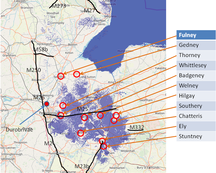
This is just a 1 metre rise in high tide level but you can see that a lot of the inland land would be flooded.
This map is derived from flood.firetree.net and shows the effect of a 1 metre rise in high tide levels in the Wash in Eastern England.
|
| |
|---|
This map shows the sea level raised by 2 metres ▲ |
|---|
This map is derived from flood.firetree.net and shows the effect of a 2 metre rise in high tide levels in the Wash in Eastern England.
|
| |
|---|
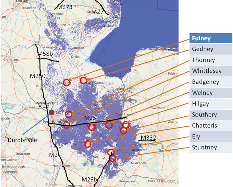
This map shows the sea level raised by 3 metres ▲ |
|---|
 This is just a 3 metre rise in high tide levels and you can now start to see the islands forming.
This map is derived from flood.firetree.net and shows the effect of a 3 metre rise in high tide levels in the Wash in Eastern England.
|
This map shows the sea level raised by 4 metres ▲ |
|---|
This is a 4 metre rise in high tide levels and the islands becoming obvious.
This map is derived from flood.firetree.net and shows the effect of a 4 metre rise in high tide levels in the Wash in Eastern England.
|
| |
|---|
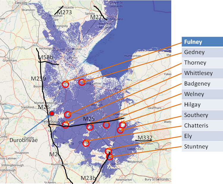
This map shows the sea level raised by 5 metres ▲ |
|---|
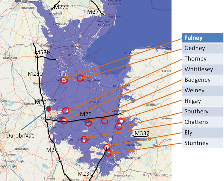
This is the final slide at 5 metres and shows the æg's as islands.
It also shows the proximity to the proposed coastline of the Roman Roads M250, M26 and M2 explaining why they were built where they are. Also the Roman town of Durobrivae at Water Newton would have been a sea port.
Also if you look at the other Roman roads plotted by Margary, they all appear to end on the coast.
This map is derived from flood.firetree.net and shows the effect of a 5 metre rise in high tide levels in the Wash in Eastern England.
|
| |
|---|
Other Evidence ▲ |
|---|
The Wash is not an isolated example. Two further lines of evidence support the same conclusion:
Was the sea level in Saxon times 4 to 5 metres higher? — Pevensey
The same place-name analysis applied to the Pevensey Levels in Sussex produces identical results, with settlements bearing -ey names only becoming true islands when sea level is raised by 4 to 5 metres. The 2026 geological paper by Dr Roger Higgs provides direct physical evidence from Pevensey Castle to confirm this.
Roman locations that have not been identified and roads that just terminate
Across England, a number of Roman roads end abruptly at or near the present coast, and several known Roman settlements remain unlocated. A tidal range 4 to 5 metres higher than today would place many of these terminals directly on the Saxon-era shoreline, suggesting the roads led to harbours and ports that are now lost beneath later sediment or reclaimed land.
|
Scientific papers that support this concept ▲ |
|---|
A recent scientific paper published in 2026 has provided compelling geological evidence for a major sea-level event in the 5th century, directly corroborating the theory developed on this site from place-name and topographic analysis. This new evidence transforms our understanding from a plausible hypothesis into a well-supported model of rapid coastal change during the Early Anglo-Saxon period.
The Article:
English Coastal Archaeological Evidence of a Fifth-Century (Dark Ages) 4-Meter Sea-Level Rise in 70 Years, Portending a Similar Rise Imminently
Please click on the following link to see the paper from the Journal of Coastal Research if this doesn't work, please copy and paste the following into a browser [ https://jcr.kglmeridian.com/view/journals/coas/42/1/article-p165.xml ] then click the 'Download pdf' button.
Written by Dr Roger Higgs and published online January 2026 in the Journal of Coastal Research.
|
Research Findings ▲ |
|---|
|
The scientific evidence for a 5th-century sea-level rise is particularly relevant to the Wash, where the low-lying Fenland topography would have made the region exceptionally vulnerable to marine inundation. A 4-metre rise would have transformed the entire Fenland basin into a tidal estuary, isolating the æg settlements on higher ground exactly as their names suggest.
1. Introduction: New Scientific Corroboration
A scientific paper above has provided compelling geological evidence for a major sea-level event in the 5th century, directly corroborating the theory developed on this site from place-name and topographic analysis. This new evidence transforms our understanding from a plausible hypothesis into a well-supported model of rapid coastal change during the Early Anglo-Saxon period.
2. Summary of the Key Scientific Finding
A study of coastal archaeological sites across England, including the Roman fort at Pevensey, demonstrates that a rapid relative sea-level rise of approximately 4 meters occurred within roughly 70 years, spanning the period ~430-500 AD (the early "Dark Ages"). This was a major marine transgression that dramatically reshaped the coastline.
3. Connecting the Evidence: Place-Names Meet Geology
The convergence of evidence is striking:
- Geological Proof: At Pevensey Castle, excavations found early-5th-century tidal mud within the defensive ditch at a level over 2 meters higher than the fort's original foundations. This indicates the high-tide water level rose significantly after the fort was built, undermining its walls by the mid-to-late 5th century.
- Historical Geography Explained: This ~4-meter rise is precisely the scale required to transform the settlements with "-ey" (from Old English æg, meaning island) on the Pevensey Levels into true tidal islands. The scientific data confirms the landscape model derived from place-names and flood maps.
4. Broader Historical Implications
This rapid environmental change likely had profound historical consequences. As noted in the research, it may help explain the mass migration of Angles and Saxons to southeastern Britain in the 5th century. Their homelands on the North Sea coastal plains may have become increasingly inundated and uninhabitable, "squeezed" between the encroaching sea and other population pressures.
5. Modern Context and Conclusion
The combination of historical geography (place-names and topography) and modern geological science now presents a coherent and evidence-based picture of a pivotal environmental event at the dawn of English history.
|
Conclusion ▲ |
|---|
The evidence from the Wash independently corroborates what the Pevensey Levels suggest: the high-tide mark in early Anglo-Saxon times stood at roughly 4 to 5 metres above its current level.
The convergence is striking. Saxon place names ending in æg — Ely, Thorney, Hilgay, Gedney, Welney and the rest — only become genuine islands at that water level. Roman roads terminate precisely where the Saxon-era coastline would have been. The Time Team's causeway at Bawsey St Peter points to an island that no longer exists as such. And the 2026 geological paper by Dr Roger Higgs provides physical confirmation of a rapid 4-metre marine transgression centred on the period 430–500 AD.
The Fenland landscape we see today — flat, drained, and largely agricultural — bears almost no resemblance to the tidal estuary and archipelago of islands that early settlers would have known. The æg names are the clearest surviving record of that vanished world.
Modern drainage, sea defences, and centuries of land reclamation have obscured just how dramatically this coastline has changed. The maps above are an attempt to make that transformation visible.
|
Translation of the names on the above maps ▲ |
|---|
This list shows our current translation of the locations shown on the above maps.
These come from our snippet theory of settlement names which we believe the Saxons and other earlier settlers used to describe the location and or use of the place.
Click here to translate a location
The following list of islands from the maps are all Saxon derived names
- Fulney - ful derived from ful - foul / ney derived from en æg - en - 'people of' and æg - 'an island'
- Gedney - ged derived from ced - boats / ney derived from en æg - en -' people of' and æg - 'an island'
- Thorney - thorney derived from þorn æg - thorn island
- Whittlesea - whittle derived from watel - wattle(woven twigs) / sea derived from æg - an island
- Badgeney - / ney derived from en æg - en - 'people of' and æg - 'an island'
- Welney - wel derived from wille - A well, spring, fountain / ney derived from en æg - en - 'people of' and æg - 'an island'
- Hilgay - hil derived from hyll - a hill / gay derived from æg - an island
- Southery - souther derived from suþ - southerly / ending in y derived from æg an island
- Chatteris - chatter derived from ceder - cedar trees / ending in 'is' derived from æg - an island
- Ely - ely derived from el æg - eel island
- Stuntney - stunt derived from stenc - stench / ney derived from en æg - en - 'people of' and æg - 'an island'
|
| |
|---|
Links to other Documents ▲ |
|---|
|
|
|
The pages below show links to documents that reference pages concerning The Variable Ocean.
These pages discuss the apparent historical Sea Level changes that have been found across the UK, their implications and the creation of a theory of Sea Level changes that incorporates these observations.
For the individual pages please click on the links, new documents will be auto populated as and when these
are written.
| |
|
;)


