|
 | Anglo Saxon History |  | |
| | Saxon Place Names (islands) |
|---|
My current theory on Saxon Place Names
In 2000 I was looking at the place names around Hastings, which all appear to be Saxon, with a very few exceptions, and wondered what they meant.
My research lead me to conclude that this area was settled between the take over of Kent by Henghest and Horsa, and the take over of the South Downs area by Aelle, so around 465AD, and was settled by the Saxons.
If you are interested in this invasion please take a look at The sequence of the Saxon Invasion
As a lot of villages have similar snippets in their name and I wondered if each of these meant something, and that this in turn might mean that the settlement names described the use or surroundings of a place.
I am not a historian, so until 2026 I had not come across the Gelling-Cole Hypothesis, but this seems to fit well with my stuff. I have also in 2026 found an academic document written by Dr Robert Higgs from the 'The Journal of Coastal Research' which discusses sea levels in early Saxon times, this also fits my research.
So what could these snippets mean ??
My conclusions may seem surprising but please read Places containing the snippet æg meaning island before reading any other snippet pages as this explains the reason for the '4.5 metre line' described in other snippets.
| | |
|---|
| Our modern term island is derived from the Anglo Saxon æg land |
|---|
Our modern term island is derived from the Anglo Saxon æg land
æg(is pronounced ay and means sea) and land(as we use the word) so æg land actually translates into sea land(land surrounded by water) and was probably originally pronounced as 'ay land'.
From my research the following early Saxon name snippets are associated with islands.
- ending in eye - example Horse eye
From the Saxon - hors æg -meaning horse island - Pevensey Marsh
- ending in ey - example Horsey
From the Saxon - hors æg - meaning horse island - East Coast of Norfolk
- ending in ay - example Hilgay
From the Saxon - hyll æg - meaning hilly island - The Wash
- ending in et - example Thanet
From the Saxon - þegn æg - meaning thane's island - East Kent
- ending in ly - example Ely
From the Saxon - él æg - meaning the eel island - The Wash
- ending in ney - example Bardney
From the Saxon - barda en æg - meaning the people of the boat island - The Wash
- ending in sea - example Brightlingsea
From the Saxon - briht el aeng æg - meaning the people of the bright fort island - Essex
- ending in ye - example Rye
From the Saxon - úter æg - meaning the outer island - East Sussex
- ending in is - example Chatteris
From the Saxon - caefer æg - meaning insect island (probably a later name) - The Wash
- starting in eg - example Egham
From the Saxon - æg hamm - meaning the island in the valley
The term 'Isle' which is just a short form of 'Island' appears to be a later addition to the language as the early islands of Thanet and Oxney have had 'Isle of' attached to the original name, these must have been added some time after the original meaning æg of was lost.
It is likely that 'Chatteris' was a later name and may have originally been 'Chatter æg land', as it seems probable that the suffix is is of this later type .
| | Issues with these places being islands |
|---|
A significant number of these locations are now a long way inland, so how could they have been islands ?
The following pages explain my findings as to the origin of the ay's
| | The æg snippets found in the Pevensey Marsh in East Sussex |
|---|
The following button will take you to my analysis of the Islands in the Pevensey Marsh which explains how to visualise these islands.
| | The æg snippets found in The Wash |
|---|
The following button will take you to my analysis of the Islands in The Wash which explains how to visualise these islands.
| | Implications of the above articles -> 4.5metre high tide |
|---|
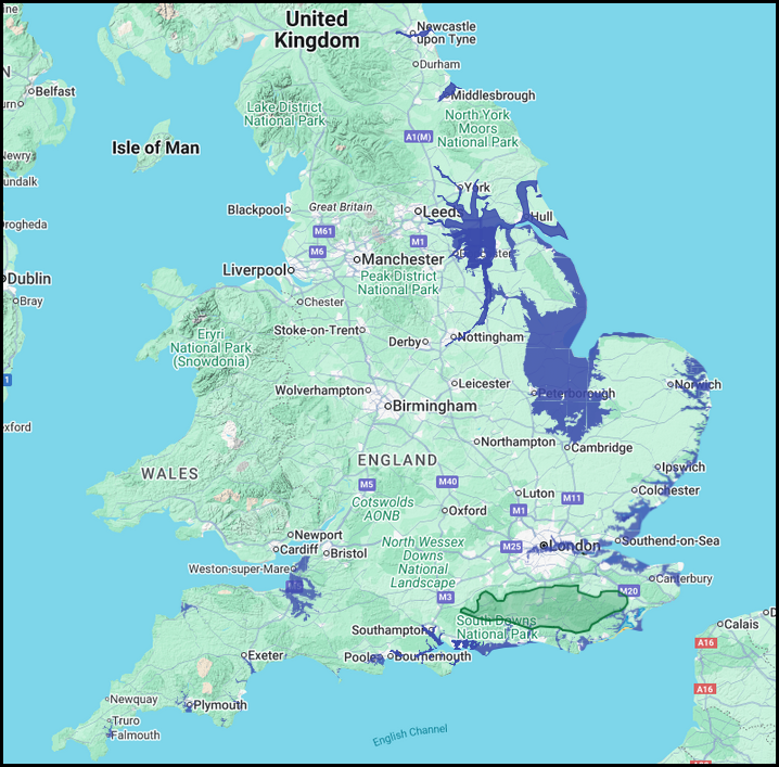
The implication of the above two articles is that the high tide level in Later Roman/Early Saxon times was about 4.5 metres a little higher than today.
There is a possibility that the high tide level rise was only 2 - 3 metres higher as the areas I have used for the analysis, the Fens and the Pevensey Marshes have been drained over time and therefore the land has sunk by about 2 metres due to the drying out of the underlying peat.
However, the 4.5 metre mark would then show the high tide mark in these areas.
| | Other Articles implying the high tide level at 4.5 metres |
|---|
| | Conclusion |
|---|
From all the above pages it would seem that there is a likelyhood of the high tide reaching about 4.5 metres above the current sea level, this has interesting implications for the landscape and coastline when we are looking at the historic landscapes.
|
Map showing the effect of the 4.5 metre high tide mark
|
|---|

|
|
|
|
|
| |
|
|
Local Interest
Just click an image |
|
|
|
|
|
|
|
|
|
|
|
|
| |
|
|