| Delgovicia at Fimber – Antonine Iter I | Saxon History |
|---|
| |
|---|
INTRO SUMMARY |
|---|
| Intro Summary ▲ |
|---|
|
The Antonine Itinerary, a Roman road register compiled in the late 2nd or early 3rd century AD, records a station called Delgovicia on Iter I — yet its precise location has never been conclusively established. This page presents a multi-strand case for Fimber, on the Yorkshire Wolds, drawing on road network analysis, military topography, archaeological morphology, and place-name etymology. The convergence of these independent lines of evidence makes Fimber the most geographically and logistically coherent candidate yet proposed.
| | |
|---|
Introduction ▲ |
|---|
|
The precise location of Delgovicia, a key station recorded in Iter I of the Antonine Itinerary, has long been a subject of debate in Romano-British landscape archaeology. Iter I tracks the final leg of the route from Delgovicia to the coastal terminus of Praetorio (traditionally associated with a major coastal garrison or Praesidium near the Flamborough/Bridlington headland) as exactly 25 Roman miles (MP XXV).
By analyzing the interconnected Roman road network, tactical military logistics, localized topography, and place-name evidence, a compelling case can be made for locating this lost imperial station precisely on the ridge-top bottleneck at Fimber.
| | |
|---|
Previously proposed locations for Delgovicia ▲ |
|---|
|
Scholars have historically proposed several alternative sites for Delgovicia, none of which satisfactorily resolve all the available evidence. Millington, on the southern edge of the Wolds, has been a long-standing candidate supported in part by its proximity to known Roman activity; however, the road-distance calculation from the coastal terminus at Praetorio falls consistently short of the 25 Roman miles recorded in the Itinerary. Wetwang, lying slightly further north on the chalk plateau, has also been suggested, but the junction infrastructure there does not support the scale of a formal posting station, and the topography offers little of the commanding defensive advantage that an official Itinerary stop would demand. A small number of researchers have pointed to Sledmere as a possibility given its position on RR811, though it lacks both the road-junction geometry and the morphological footprint expected of a mansio (a larger official inn and administrative posting house) or mutatio (a road-side relay station for changing horses) complex.
Fimber alone sits at the convergence of not two but three Margary routes — RR810, RR811, and RR813 — a triangular junction of a significance that none of the alternative sites can match, and one that would logically demand an official Roman presence to manage and tax the traffic passing through it. No other proposed location satisfies the distance requirement, the triangular junction logic, the ridge-top defensive profile, and the fossilised square enclosure simultaneously.
| 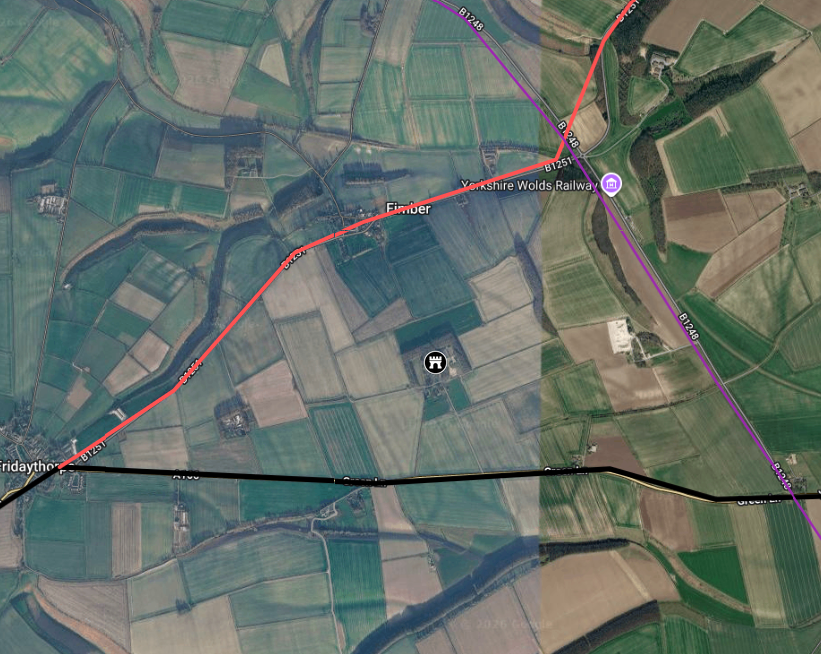
Map showing the area and proposed location of the fort.
The thick black line shows the major route of Margary 810 a massive route from York to Petuaria.
The red line shows the smaller Margary 811 military road that allows faster transit from Fridaythorpe to Petuaria
The purple line shows the Margary 813 road that was probably a prehistoric ridgeway corridor utilised in the Roman period.
| | |
|---|
The 810, 811 and 813 Triangular Junction Model ▲ |
|---|
|
Most historical evaluations of Iter I treat Roman routes as static, linear lines, assuming the journey strictly followed a single road from start to finish. A more realistic model of Roman military logistics recognises that infrastructure was designed as a fluid, interconnected network of primary arteries and high-speed tactical connectors.
Margary Route RR810, running from York through Stamford Bridge, was an exceptionally wide highway measuring between 9 and 15 metres across. This extraordinary width indicates a heavy-freight, high-volume commercial artery built to move massive wagon trains, grain, and supplies between the regional capital at Eboracum (York) and the protected fleet anchorage at Bridlington Bay.
At Fimber, however, the situation is more remarkable than a simple crossroads. The fort sits within a triangle formed by three converging Margary routes — RR810, RR811, and RR813 — creating one of the most significant road junctions on the northern Wolds. This triangular network geometry is a strong indicator of deliberate Roman infrastructure planning; such configurations were not accidental but were engineered to allow traffic to switch efficiently between routes depending on destination, load, and speed.
For a fast-moving military unit, imperial courier (cursus publicus — the state-run road transport and communication network), or tactical detachment, switching from the busy RR810 freight highway onto the unobstructed RR811 or RR813 ridgeway would be significantly quicker, offering an express route across the high ground that avoided the congested coastal plain. When tracking the distance of this specific route combination from the Flamborough coast, it lands precisely at the 25 Roman mile marker at Fimber.
| | |
|---|
The Strategic Topography of Fimberfield House ▲ |
|---|
|
An official Itinerary station required a location that optimised both communication and security. In Fimber, this exact tactical advantage is found on the prominent ridge on the southern side of the village currently occupied by Fimberfield House, or slightly to the north-west, as LiDAR imagery suggests.
The ridge sits directly within the triangle of the junction, commanding an immediate, multi-directional view overlooking RR810, RR811, and RR813 simultaneously. From this vantage point, a detached Roman officer (beneficiarius — a military administrator assigned to monitor key road junctions and collect road-tax) could easily monitor all traffic approaching from any of the three transport corridors. Furthermore, the ridge maximises line-of-sight visibility for smoke or torch signalling networks across the high Wolds, while remaining in close, defensible proximity to the ancient village ponds — the only reliable water source for miles on the dry chalk downs.
| | |
|---|
Anomalous Morphology: The Square Footprint ▲ |
|---|
 The physical geometry of the modern property boundaries at Fimberfield House preserves a distinct archaeological signature. In a region where later medieval village layouts evolved into organic, curving strip fields, the sharp, rectilinear square boundary of the grounds on top of this ridge stands out as a significant anomaly.
This layout represents a classic "fossilized boundary." Standard Roman posting stations were constructed as secure, square courtyard complexes containing stables, granaries, and administrative quarters. Alternatively, the site may represent a high-status Iron Age square enclosure reused by the Roman military. When subsequent Anglo-Saxon and medieval builders established the historic manor, they did not clear away the deep, substantial foundations on the hill. They simply built their farmsteads and boundary walls directly over the existing footprint, locking the ancient Roman square geometry into the modern landscape.
| | |
|---|
Etymological Evidence: The Out of the way Place ▲ |
|---|
|
The name Delgovicia is Romano-British rather than standard Latin — a hybrid of Celtic and Latin elements that has resisted simple translation. Historians have proposed several derivations based on its component roots. The most widely cited reading draws on the Celtic tribal name Delgovices, giving the meaning "place of the spear-fighters" — suggesting a military garrison population that gave the settlement its identity. A second derivation, and arguably the most geographically revealing, derives the name from Latin devium (out of the way, remote, off the road) and vicinia (neighbourhood, settlement) — giving the whole name the meaning "the out-of-the-way place" or "the settlement set apart."
It is this second reading that is most striking in the context of Fimber. The village sits on RR811, but the official station — the fort or mansio — appears to have occupied the Fimberfield House ridge above, set deliberately back from the road within the triangle. A posting station positioned here would have been, by design, removed from the bustle of the freight highway below: visible to those who needed to find it, unremarkable to those who did not. The name may therefore be less a description of isolation and more a precise topographical statement — this is the official installation that sits apart from the road. That a name meaning "the out-of-the-way place" should survive attached to a quiet Yorkshire Wolds village, with its fort tucked on a ridge within a triangle of Roman roads, is difficult to dismiss as coincidence.
The Fimber place-name itself adds a further layer. Traditionally derived from Old English fīn (a woodpile or stack of fuel) and mere (a pond) — "the woodpile by the pond" — this matches the resource profile of a major Roman crossroads station, which required constant timber stocks to fuel courier quarters, signalling beacons, and roadside smithies. However, given the phonetic blurring of suffixes over centuries of oral transmission, the second element -ber can also be read as a derivation of burh (a fortified place or timber fort), shifting the meaning to "the wooden fort" or "the fortified woodpile." When Anglo-Saxon settlers arrived, they appear not to have found a natural landscape feature but a distinct, man-made defensive structure standing on the hill above the road. The place-name survives as a fossilised memory of the square timber compound that secured this vital crossroads.
| | |
|---|
Conclusion ▲ |
|---|
|
Taken individually, each strand of evidence presented here might be dismissed as circumstantial. Taken together, they form a mutually reinforcing case that is difficult to explain away. The precise 25 Roman mile distance calculation, the triangular junction of RR810, RR811, and RR813 — a three-road convergence unique in the immediate landscape — the commanding position of the Fimberfield House ridge at the centre of that triangle, the anomalous square morphology of the modern property boundary, the fossilised Fimber place-name preserving the memory of a fortified timber structure, and the name Delgovicia itself meaning "the out-of-the-way place" — each of these strands supports the same conclusion independently. No other proposed location for Delgovicia satisfies all six criteria simultaneously.
While definitive confirmation would require targeted geophysical survey or excavation at the Fimberfield House ridge, the spatial, infrastructural, topographical, morphological, and etymological evidence presented here makes a compelling argument that this quiet Yorkshire Wolds village preserves, in its very name and layout, the memory of a lost imperial station on the road to the sea.
|
|
|
;)
)


