| Roman Ironworking in the weald and why it declined |
|---|
| | |
|---|
Classis Britannica - Background ▲ |
|---|
From Wikipedia
'The Classis Britannica (literally, British fleet, in the sense of 'the fleet in British waters' or 'the fleet of the province of Britannia', rather than 'the fleet of the state of Britain') was a provincial naval fleet of the navy of ancient Rome. Its purpose was to control the English Channel and the waters around the Roman province of Britannia. Unlike modern (and some contemporary Roman) "fighting navies", its job was largely the logistical movement of personnel and support, and keeping open communication routes across the Channel.'
A fleet was originally raised for the invasion of Britain under Claudius, with the task of bringing an invasion force of 40,000 men from the Roman army, plus supplies, to Great Britain. It continued after the successful invasion to provide support for the army, shuttling massive quantities of supplies across the English Channel.
Its original purpose was for transport, and as such had limited fighting vessels, it would seem that the fleet was responsible for the industrialisation of the iron working in the Weald due to the number of tiles found in the area marked CLBR.
It would seem that production knowledge improved significantly over the centuries as small bloomeries were superceeded by much larger production sites such as Beauport Park, Oaklands and Footlands near Battle and Bardown near Stonegate.
| The Strategic Value of the Weald ▲ |
|---|
The invasion of Britannia in 43 AD was not simply a military campaign. The Wealden iron deposits of Kent and Sussex had supplied iron to Gaul across the Channel for generations before the legions arrived. Control of that supply — and denial of it to enemies — was a strategic objective from the outset. The Classis Britannica, Rome's Channel fleet, was assigned operational control of the Weald within a generation of the conquest, evidenced by the stamped CL BR tiles found at production sites across the region. This was not a contractor's mark. It was an ownership mark, indicating that the land, the ore, the timber and the labour all belonged to the Emperor through his fleet.
| The Military Enclosure of the Weald ▲ |
|---|
The Classis Britannica did not merely manage individual sites. It enclosed the entire forest zone within a military boundary whose infrastructure still survives in the place names of Kent and Sussex. Along the Greensand ridge from Starborough near Edenbridge eastward through Harborough, Hallborough, Crowborough, Bidborough and Southborough to Tonbridge, a chain of military installations watched the northern forest edge — their names preserving the Old English burh, a defended position, and in several cases the specifically military here-burh, an army fort. The western boundary ran along Margary road 15 through the western Weald edge near Liphook and Petersfield to Chichester (Noviomagus), the civitas capital of the Regnenses. The eastern boundary closed at Portus Lemanis (Lympne). The southern boundary was the coast itself, with the Saxon Shore forts completing the enclosure. Inside this perimeter the Weald was an imperial military zone — not a civilian landscape with military installations in it, but a controlled resource area managed as a single strategic asset.
| Classis Britannica - CL BR — Fleet, Forest and Iron ▲ |
|---|
|
The Classis Britannica held two resources simultaneously within this boundary: iron ore in the valley floors and oak timber on the hillsides. Both were essential to the same purpose. Iron was shipped across to the fleet headquarters at Boulogne for processing into weapons, armour and ship fittings. Oak was worked into planks at the forest edge and moved by road and river to the coastal shipyards, where it became the hulls of the cargo vessels and warships that maintained Rome's Channel control. The CL BR tile stamps found at Bardown near Stonegate, Beauport Park near Battle, and at sites across the eastern Weald confirm direct fleet management of the largest production centres. The military boundary was the enforcement mechanism — controlling access to the zone, supervising the workforce, and ensuring that production served imperial rather than local interests.
| | |
|---|
Main iron production period AD43 to AD290 ▲ |
|---|
Iron production and logistics
The fleet appears to have been an intrinsic part of the Roman period Wealden Iron industry, evidenced by the stamped tiles found locally.
Initially the industry appears to have used a multitude of small bloomeries, probably initially created by the indigenous celts to make iron pigs(bars) which were hammered into shape.
The iron produced in the Rother valley was shipped across to the Fleet headquarters at Boulogne in Gaul, probably via Portus Lemanis the harbour near to modern Hythe. The iron produced in the Brede,Tillingham and Combe haven valleys were probably shipped from the Pevensey area.
To carry the iron required large numbers of strong cargo vessels, which could be easily made from the Oak trees that were numerous in the Weald and which could be easily accessed via the Pevensey level, the Combe valley and the Rother.
The trees bordering the Brede and Tillingham valleys were much more likely to have been used for charcoal production due to the proximity of the large later production sites which required vast amounts of fuel.
During this time the Rother/Limen would have reached the sea at modern Hythe about 20 miles away from its current mouth at Rye.
For further details on the Roman Empire Iron Production click this link Roman Iron Producing Regions and Production
| Production Phase One — AD43 to AD100 — Exploration ▲ |
|---|
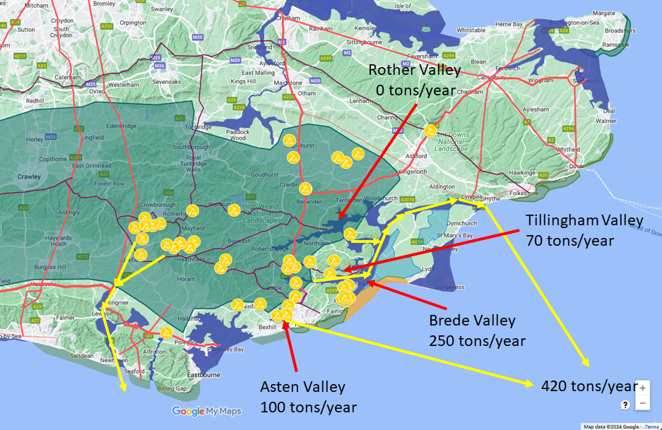 In the first century after the conquest the industry operated from numerous small bloomeries scattered across the eastern Weald and the coastal river valleys, working in a similar way to the pre-Roman Celtic operations they replaced or absorbed. The main production came from the Brede valley, the Asten valley and the Tillingham valley, producing perhaps 420 tons of iron per year in total.
Shipbuilding was as important as iron from the outset — the proximity of the Andredsweald forest to tidal water made the construction of cargo and transport vessels a natural companion industry to the ore processing. The boundary infrastructure was established during this period, creating the framework within which the later expansion would operate.
| Production Phase Two — AD101 to AD200 — Consolidation ▲ |
|---|
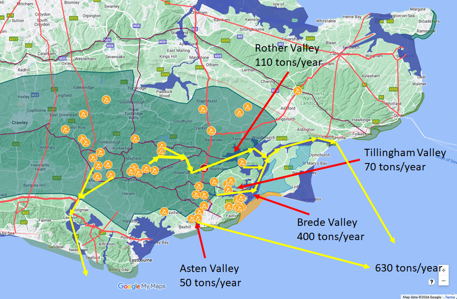 In the second century production was concentrated into fewer, larger sites and output increased significantly to perhaps 630 tons per year. The Rother valley came into full production with its main river port at Bodiam, where a Roman port has been identified. Bardown and Beauport Park grew into major industrial complexes, each covering several acres and processing iron at a scale the earlier bloomeries could not approach.
The CL BR stamp is most densely attested in this period, confirming direct fleet management at peak intensity. The military boundary was fully operational, with the Greensand ridge chain, the coastal road system and the Saxon Shore fort construction all proceeding simultaneously.
| Production Phase Three — AD201 to AD300 — Full Industrial Scale ▲ |
|---|
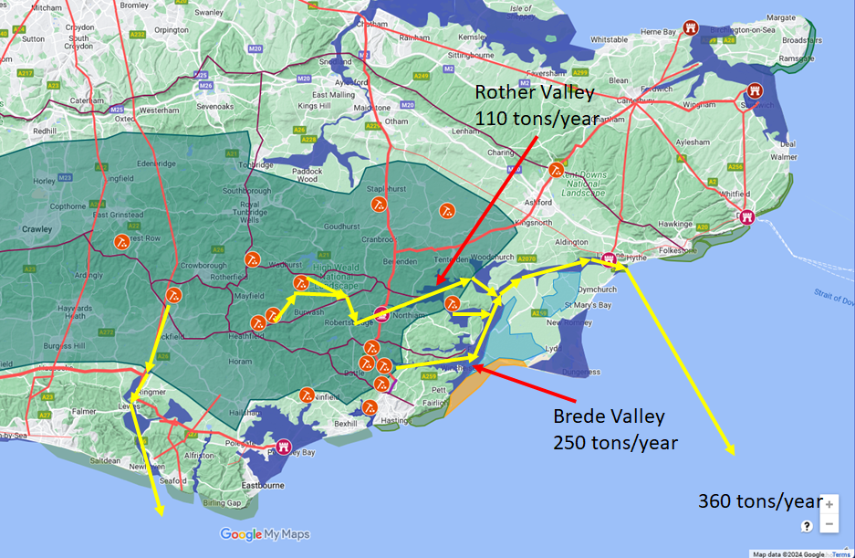 By the third century the industry was concentrated at a smaller number of very large production sites — Bardown, Beauport Park, Oaklands and Footlands — each approximately 200 metres square and producing iron on an industrialised scale. Overall tonnage was somewhat lower than the second century peak, partly reflecting the political disruptions of the period.
The breakaway Gallic Empire founded by Postumus in 260 AD reduced demand from the continent, and Carausius's declaration of independence from Rome in 286 AD further altered the supply relationships. Significantly, the construction of the major Saxon Shore forts — including Anderida at Pevensey — drew heavily on the Wealden workforce during this period, with the Classis Britannica apparently directing labour between iron production and fort construction as strategic priorities shifted.
| Carausius — The Weald as an Independent Power Base ▲ |
|---|
When Marcus Aurelius Mausaeus Carausius declared himself Emperor of Britain and northern Gaul in 286 AD, he did so from a position of extraordinary industrial and military strength. As commander of the Classis Britannica he already controlled the entire Wealden military zone — the boundary infrastructure, the production sites, the shipyards, the coastal forts and the fleet. The iron of the Weald, the oak of the Andredsweald and the skilled workforce that had been built up over two centuries of imperial management were all at his disposal.
His fleet, built in the Pevensey lagoon and at Lemanis from Wealden timber and iron, defeated Maximian's attempted reconquest in 289 AD. For a decade he held the Channel against Rome using the resources of a zone that Rome itself had created and developed. For the full strategic context of the Pevensey base, see the Carausius and Pevensey page and the Saxon Place Names of Pevensey.
| Production Phase Four — AD296 to AD400 — Deliberate Contraction ▲ |
|---|
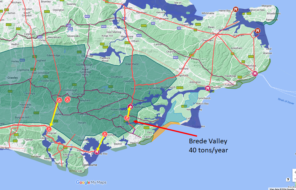 When Constantius retook Britain in 296 AD, Pevensey surrendered without a siege and the boundary infrastructure was inherited intact. The iron industry was not. Within a generation, production collapsed from hundreds of tons per year to perhaps forty tons, concentrated in just two coastal sectors — the Ouse corridor from Oldlands and Oaky Wood down through Barcombe Mills toward Newhaven, and the Ashburnham and Boreham Street sites on the Combe Haven drainage feeding toward the Pevensey coast.
This was not economic decline. It was deliberate strategic policy. Constantius had just spent a decade fighting an emperor whose power rested entirely on Wealden iron and Wealden oak. He was not going to leave that resource base available to the next ambitious commander.
| Divide and Control — The Post-296 Settlement ▲ |
|---|
|
The key to understanding the 4th century pattern is geography. The two surviving production sectors drained to two different coastal sectors under two different garrison commands. The Ouse corridor fed toward Newhaven and the western coast. The Ashburnham and Combe Haven corridor fed toward Pevensey, garrisoned after 296 by the Numerus Abulcorum — a continental limitanei unit with no connection to the Classis Britannica tradition.
The Brede and Rother valleys, where Footlands and Bodiam continued minimal production, drained to Lemanis, garrisoned by the Numerus Turnacensium, equally unconnected to the old fleet command. Neither garrison was a naval unit. Neither had the institutional relationships with the Wealden workforce that Carausius had inherited and exploited. No single commander controlled both production sectors simultaneously.
Coordination of sufficient iron and timber for serious fleet-building required imperial authorisation to direct both garrison commands together. This was not accidental posting. It was the structural prevention of the conditions that had made Carausius possible — a classic Roman administrative solution, dividing to prevent any recurrence of unified control.
| | |
|---|
The Garrison Choices as Policy ▲ |
|---|
|
The Notitia Dignitatum, compiled around 395-410 AD, records the unit dispositions across the Saxon Shore. At Anderida the Numerus Abulcorum, probably of Danubian origin. At Lemanis the Numerus Turnacensium, from Tournai in northern Gaul.
The choice of these specific units is as deliberate as the production geography. Continental limitanei with no Channel experience, no relationship with the local population, and no knowledge of the Wealden supply networks could garrison the forts competently as defensive installations. They could not independently reconstruct the naval-industrial system that Carausius had commanded. Even a future usurper who captured both forts would be starting from nothing — the institutional memory, the trained workforce relationships, the logistical networks that had made the Classis Britannica so effective were all gone. Rome did not merely reduce the industry. It removed the conditions under which the industry could be dangerous.
| | |
|---|
Conclusion ▲ |
|---|
|
The end of ironworking in the Weald was not a story of exhausted deposits, economic collapse or barbarian disruption. It was an imperial decision, taken after 296 AD by a government that understood precisely why the Weald had been dangerous. For two and a half centuries the Classis Britannica had built, within its military boundary, the most integrated naval-industrial complex in Roman Britain — iron, timber, shipyards, coastal forts and a trained fleet all under unified command.
That integration was its strength and, in the hands of Carausius, very nearly its undoing. Constantius's response was to dismantle the integration while preserving just enough capacity for maintenance and coastal defence. The 4th century site distribution, the garrison choices, the fragmented command structure — all are expressions of the same strategic logic.
The Weald was made safe by being made insufficient.
Further details about the Wealden Iron Industry can be found on the Wealden Iron Research Group Website
For our article on Iron production across the Roman Empire click the following link Roman Iron Producing Regions and Production
| Further Reading ▲ |
|---|
|
|
|
;)