| The Land That Fed the Roman Fleet — Saxon Place Names of the Ouse and Cuckmere Corridor |
|---|
| Introduction ▲ |
|---|
|
While these location names stem from Anglo-Saxon origins, they directly identify and describe the foundational Roman infrastructure, farming, and coastal trade routes that existed centuries prior.
When Saxon settlers moved into the coastal plain between the Ouse mouth at Newhaven and the Cuckmere valley in the fifth and sixth centuries, they found a landscape that had been feeding a fleet for three hundred years. The place names they gave to what they found are not the names of pioneer farmers clearing virgin ground. They are the names of an organised agricultural and tidal economy — grain fields, sheep runs, fish frames, salt workings — still legible in its layout and still functioning in its essentials when the first Saxon settlers needed to call it something.
This page should be read alongside the Saxon place names of the Pevensey levels, which covers the industrial supply chain of the naval base — the timber, rope, shipbuilding and iron supply systems running south from the Andredsweald. The two pages describe the same operational base from different directions. Pevensey needed a forest to build its fleet. It also needed a larder to feed the men who built, maintained and crewed it. That larder was here, in the ten miles of downland, vale and tidal margin between the Ouse and the Cuckmere.
The landscape has three distinct agricultural zones stacked between the coast and the Weald. On the open chalk of the Downs themselves, sheep grazed the wide dry grassland that the chalk produces and that nothing else in southern England replicates. Behind the scarp, in the sheltered clay vale between the Downs and the Weald edge, grain grew in organised field systems whose boundaries Margary documented still visible on the ground. On the tidal margins of the Ouse flood plain, where the sea pushed shallow brackish water across wide flat ground twice a day, fish frames worked the tidal flow and salt evaporated in the pans beside them. Three supply systems, three landscape types, all within a day's movement of the Pevensey lagoon.
The Classis Britannica had been supplying a permanent naval presence from this coast since the early second century. What Carausius changed was not the system but its scale. A patrol fleet requires provisioning. A Channel-controlling battle fleet building new vessels simultaneously requires the same landscape running at maximum output — more grain, more sheep, more salt, more preserved fish — pressed into intensive service to feed a larger garrison, a larger workforce and a larger fleet than the system was originally dimensioned for. The place names preserve both the system and its intensity.
The place name interpretations below are the author's own readings based on Old English etymology. Where a reading is uncertain this is stated. Readers are encouraged to disagree and to look at the source material themselves.
| | |
|---|
The Settlement Hierarchy of the Downs Corridor ▲ |
|---|
|
The Saxon settlers who named the landscape between the Ouse and the Cuckmere were not choosing names arbitrarily. The type of settlement name they used encodes its position in the landscape with a precision that is still readable today.
The highest tier is the don settlement, positioned at or immediately adjacent to an Iron Age hillfort on the chalk ridge. The don element preserves the Celtic dun — a defended high point — carried directly into Saxon usage because the structure it described was still the dominant feature of the position when the Saxons arrived and needed a name for it. Willingdon, next to the hillfort above Eastbourne, is the clearest local example and is discussed in detail on the Pevensey levels page.
Below the hillforts, the ton settlements occupy the hill slopes — working farms on elevated ground above the flood line, managing livestock and arable on the chalk and its margins. Laughton, Friston, Winton, Alfriston, Milton and South Heighton are all ton settlements, each named after the primary activity or physical characteristic of its particular position on the hill rather than after its place in the hierarchy. The ton is where the farming happens, above the water and below the defended ridge.
At the water's edge sits the ham — a settlement positioned precisely at the tidal limit, where land transport meets water transport and goods change from one to the other. The ham settlements of this corridor cluster at approximately 4.5 metres above Ordnance Datum, the tidal limit under the sea levels that prevailed during the Roman and early Saxon periods as identified by the Cumulative Thermal Lag model. Beddingham, Southerham, South Malling, Offham, Wellingham and Barcombe all carry the ham element and all sit at or close to this contour. They are not simply villages near water. They are landing stage settlements, each one a transfer point where the produce of the hills above — grain, livestock, salt, fish — was loaded onto river craft for movement coastward to the fleet.
The ham frontier was not fixed. The earliest hams cluster at approximately 4.5 metres above Ordnance Datum on the main river channels, positioned at the tidal limit where goods transferred between land and water transport. Over time the word broadened in meaning, losing its original precision as a term for a tidal landing stage and becoming more generally a settlement next to a river or large stream. Later ham settlements extend further upstream onto smaller watercourses, not because the tidal reach had contracted but because the word itself had warped to describe any waterside settlement. The original 4.5 metre clustering identifies the earliest phase — the Roman and early Saxon foundations where the term still carried its precise technical meaning.
Below the ham settlements, in the intertidal margins that no permanent settlement claimed as its own, the most productive work of all was done — salt evaporating in shallow pans, fish caught in tidal frames, eels taken from the river margins. These activities left no settlement names of their own but they left their mark on the names of the settlements above them, and on the Domesday record that counted their salthouses eight centuries after the Romans had gone.
| | |
|---|
Fishing ▲ |
|---|
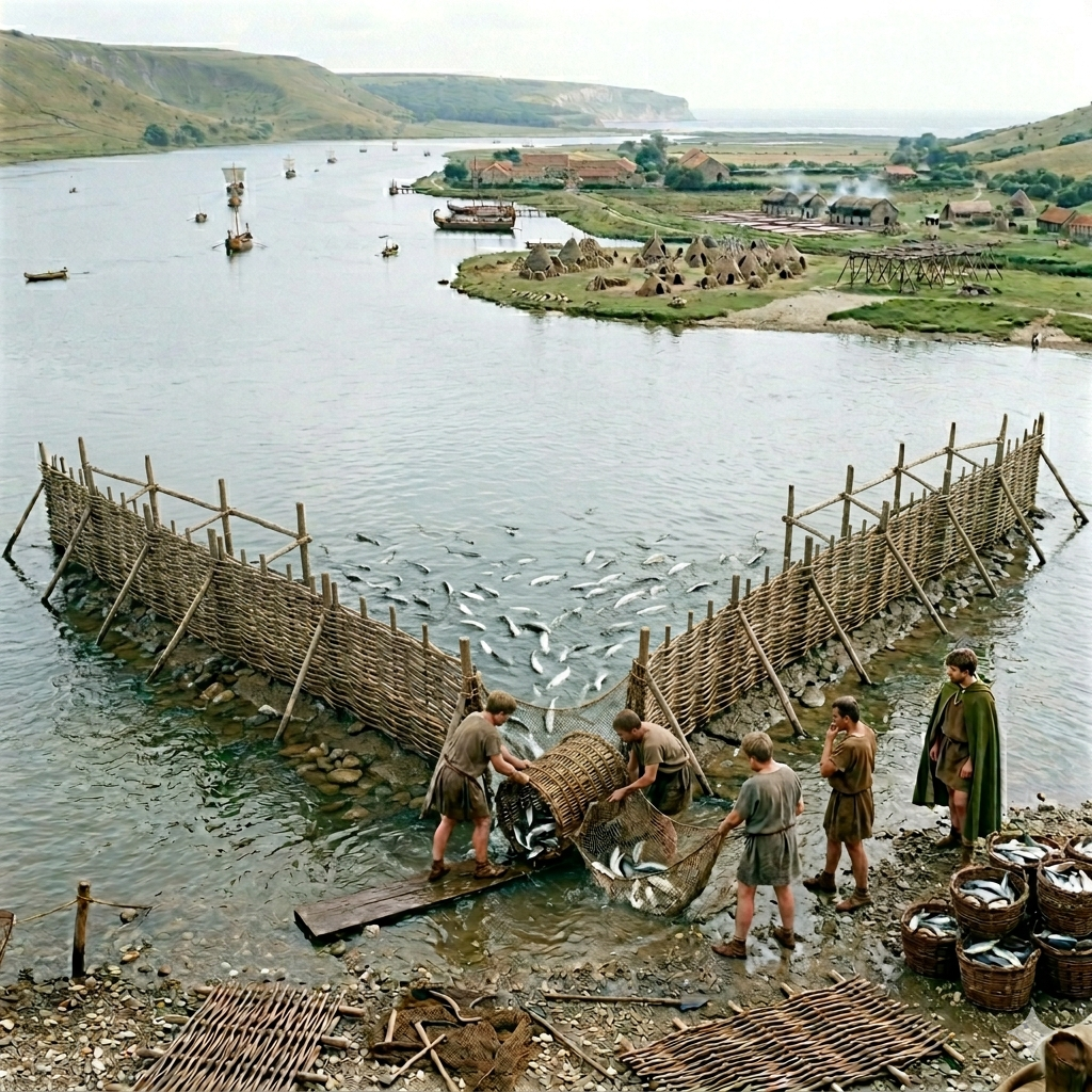 The tidal margins of the Ouse and the Cuckmere were not simply the lower edge of the agricultural landscape. They were a productive zone in their own right, worked continuously for fish, eels and shellfish by a population that understood tidal rhythms as precisely as the farmers above them understood seasons.
Glynde — glind — a fence of boards or railings. The word describes a fish trap construction — a barrier of boards or palings set across a tidal channel to intercept fish as the water rises and falls, the catch collected at low water when the trap is exposed. Glynde sits on the tidal reach of the Ouse where the shallow brackish water and the twice-daily tidal flow created exactly the conditions a fish trap requires. The same word appears at Glynleigh on the Pevensey levels, where it describes an identical structure on the lagoon shore. That two settlements in the same coastal system carry the same name for the same structure is not coincidence — it reflects a standardised technology deployed at every suitable tidal location along this coast, and the Saxon settlers naming both sites used the same word because they recognised the same thing.
South Heighton — Súþ haec dún — the southern settlement on a hill that makes fishing frames. The haec element describes a frame or rack on which fish are dried or smoked after catching — the processing stage that follows the trap. South Heighton sits on the hill above the Ouse tidal margin, the elevated position giving the drying frames the wind exposure that preservation requires. The fish come up from the water below, the frames are on the hill above, and the settlement takes its name from the processing operation rather than the catching.
Piddinghoe — Piþa hring hoe — the protected settlement on the promontory processing pith . Pith — the soft cellular material from rush stems — was used as float material for fishing nets, providing the buoyancy that holds the top edge of a net at the surface while the weighted bottom edge sinks. Piddinghoe sits on a promontory on the Ouse close to the sea, precisely where net fishing from small vessels in the lower estuary would require a continuous supply of floats. A settlement identified by its pith production on a river promontory near the sea is describing a net float manufactory serving the estuary fishery.
Rodmell — rod mell — the place where they fish and grow crops. The name describes a mixed economy settlement working both the tidal margin below and the agricultural ground above simultaneously — rod fishing in the shallow tidal channels of the Ouse alongside arable cultivation on the higher ground. That dual identity is confirmed and extended by the Domesday record, which counts eleven salthouses at Rodmell in 1086, adding salt production in the tidal margins to the fishing and arable already encoded in the name. Three economic activities — fishing, crops, and salt — operating from the same settlement at the same tidal margin position, each one using a different aspect of the same landscape. Rodmell is not a specialist site but a fully diversified tidal margin economy, and the place name preserves two thirds of that economy directly.
Alfriston — Æl fyrs tun — the hillside furze settlement near the eels. The æl element — eels — locates the productive tidal margin of the Cuckmere below the settlement, while the fyrs — furze or gorse — describes the vegetation on the hillside where the ton sits above the water. Alfriston is named after what is above it and what is below it simultaneously, the hill farm and the eel fishery bracketed together in a single place name that describes the complete vertical stack of the landscape at that point on the Cuckmere.
| | |
|---|
Sheep ▲ |
|---|
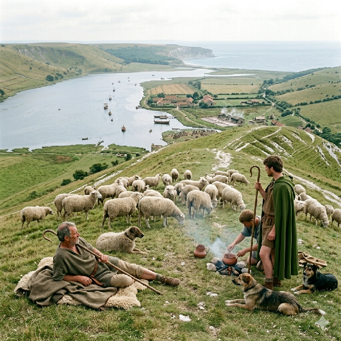 The open chalk ridge between the Ouse and the Cuckmere is sheep country by nature. The thin dry turf that the chalk produces — short, dense, mineral-rich — is the grazing that sheep thrive on and that other livestock cannot exploit as efficiently. It requires no improvement, no drainage, no clearance. It is simply there, on the ridge, available to anyone with a flock and a drove road off the scarp.
Winton — Win tun — the pasture settlement on the hill. The name says what the hill is for. Not arable, not woodland, not a defended position — pasture, the managed grazing land that a permanent flock requires. Winton sits on the chalk above the Cuckmere valley, its name encoding the primary land use of its position as precisely as any field boundary on the ground below it.
Friston — Fyrs tun — the furze settlement on the hillside. Furze or gorse on chalk downland is not an obstacle to grazing but a characteristic of it — the rough vegetation that colonises the steeper slopes and the less-worked ground at the margins of the open turf. Sheep will graze through furze where cattle cannot follow, and a settlement that identifies itself by the furze on its hillside is describing a particular type of rough downland grazing rather than improved pasture. Friston sits on the chalk above the Cuckmere mouth, on ground that is still visibly open and exposed today, and its name places it in the same continuous tradition of downland sheep management that the chalk ridge has supported since before the Romans arrived.
Telscombe — Tæsl comb — the dry valley settlement with teasels. Teasels are not a food crop or a grazing plant. They are a processing tool — the dried seedhead of the teasel was used to raise the nap on woven woollen cloth, combing the surface of the finished fabric to produce the dense even texture that made woollen goods durable and weather-resistant. A settlement in a dry valley on the chalk that identifies itself by its teasel crop is describing the downstream end of the wool processing chain — the finishing stage that follows shearing, washing, spinning and weaving, and that turns raw woven cloth into a finished product. The sheep are on the ridge above. The teasels are in the valley below. Between them, invisible in the place name record but present in the logic of the supply chain, are the washing, spinning and weaving stages that connected the living animal to the finished cloth.
The drove roads that brought sheep off the chalk and down to the ham settlements at the tidal limit are not named in the Saxon record but their logic is written in the landscape. Every ton settlement on the hill slope above a ham at the tidal limit implies a movement of animals and goods between the two — seasonal drove movements bringing sheep down for slaughter and processing, wool moving coastward to the fleet, fresh meat and preserved mutton entering the supply chain at the water's edge for loading onto river craft bound for Pevensey.
| | |
|---|
Cattle ▲ |
|---|
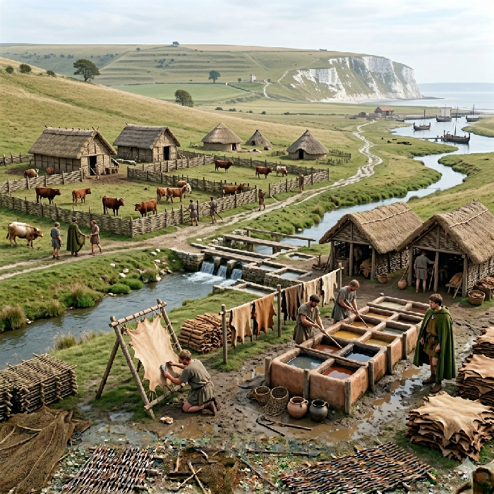 Where sheep worked the open chalk above, cattle worked the clay vale below the scarp. The heavy soils of the Ouse flood plain and its tributaries — permanently moist, well watered, carrying the dense permanent pasture that the chalk cannot produce — are cattle country in the same way that the ridge above is sheep country. The two systems are not competing but complementary, each exploiting the landscape type that suits it and together covering the complete vertical range from ridge to river margin.
Chalvington — Cealf hring tun — the ringed calf settlement on the high ground. Calves separated from the main herd for rearing on the chalk above the clay vale, the young animals on the better-drained ground while the mature cattle work the heavier soils below. The hring element — a ringed or enclosed settlement — implies a managed enclosure rather than open grazing, the young stock protected and supervised until they were ready to move down to the vale pastures. A settlement that identifies itself by its calf rearing on the high ground is describing the breeding and rearing end of a cattle operation whose productive centre is in the vale below.
Beddingham — Bedding ham — the animal bedding settlement at the water's edge. Bedding — straw management for stalled animals — implies cattle housed and fed through at least part of the year rather than left entirely on open pasture. Beddingham sits at the tidal limit of the Ouse at the 4.5 metre contour, a ham settlement at the transfer point between land and water transport. Stalled cattle at the tidal limit, adjacent to the loading point for river craft moving supplies coastward, are cattle being held for slaughter and processing before their products enter the fleet supply chain, but they are not only that. Working oxen rested and fed between hauls — the draught animals that kept the entire supply system moving — would have been stalled and managed at exactly this kind of logistics node at the water's edge. The bedding is not incidental. It is evidence of a managed holding operation serving both the slaughter line and the haulage system simultaneously.
Oxen were the engine of the entire Andredsweald supply chain. Timber felled in the forest does not move itself to the road. Iron coming off the bloomery does not reach the coast under its own power. Grain on the clay vale needs ploughing before it grows and carting before it reaches the water. At every stage of the supply operation from the forest edge to the tidal limit, oxen provided the motive power that no other technology available to the Romans could replicate at the same scale and on the same terrain. They could work the heavy clay soils of the vale that would defeat a horse team, haul loaded wagons along forest tracks that were impassable to wheeled vehicles without animal power, and sustain that work on grazing that cost nothing beyond the land it occupied. The cattle of the Ouse vale were not simply a food supply or a source of leather and tallow, essential as both of those were to a working fleet. They were the logistical foundation on which the entire supply system from the Andredsweald to the Pevensey lagoon depended.
The products that cattle provided beyond their draught work went deep into the fleet's operational requirements. Leather was a shipyard consumable needed in quantities that no modern use of the material suggests — every piece of running rigging passed through leather components, every oarsman's position required leather protection, boots and belts and scabbards and buckets and bellows at the forge all demanded continuous replacement in a working military base. Tallow — rendered cattle fat — was equally essential, used for preserving hull planking, greasing the ways on which vessels were launched, waterproofing rope and canvas, and sealing the joints in wooden structures against water ingress. A fleet of any size consumed leather and tallow faster than it consumed most other materials. The cattle of the Ouse vale supplied all of it.
| | |
|---|
Grain ▲ |
|---|
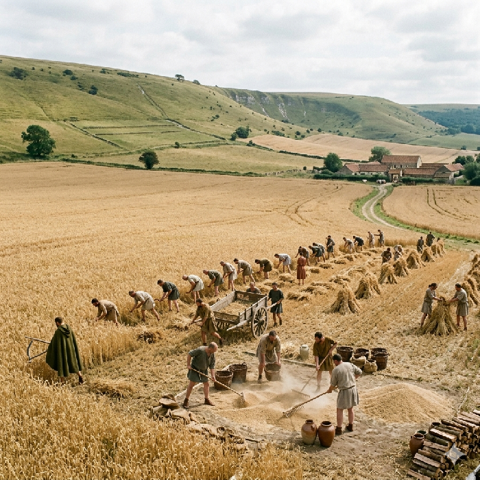 The chalk downland slopes and the clay vale behind the scarp between the Ouse and the Cuckmere produced grain in organised quantity. The evidence is not only in the place names but in the ground itself — Margary documented the field systems of this area still visible on the chalk slopes, their boundaries and lynchets preserving the outline of an arable landscape that was organised, continuous, and operating at a scale beyond subsistence. These are not the fields of scattered farmers growing enough to eat. They are the fields of a managed agricultural zone growing enough to feed a fleet.
Berwick — Ber wick — the barley vicus. The word wick derives directly from the Latin vicus — a settlement organised around a specific productive function within the Roman administrative system. A barley vicus is not simply a place where barley happens to grow. It is a settlement designated and organised for barley production within an imperial supply framework, its output directed toward a specific destination rather than a local market. Berwick sits on the chalk above the Cuckmere valley, its name preserving the Roman administrative vocabulary that organised the agricultural landscape around it as precisely as any written document could.
South Malling — Súþ mélu hring — the southern protected meal or flour settlement. Where Berwick names the raw crop, South Malling names the processed output — meal or flour, grain already ground and ready for use. The hring element implies an enclosed or protected settlement, the processing facility secured against the losses that ground flour is vulnerable to in a way that standing grain is not. South Malling sits on the Ouse above Lewes, its position on the river placing it at the point where processed grain entered the water transport system for movement coastward. The flour was ground here. The river took it from here to the fleet.
Ripe — ripe — mature, harvestable. Not a settlement name in the conventional sense but a field name that has become a place name, describing the agricultural condition of the land rather than any structure or community on it. A place named after the state of being ready for harvest is a place defined entirely by its arable function — the grain fields so dominant in the landscape that the settlement took its identity from them rather than from any other feature. Ripe sits in the heart of the arable zone between the Ouse and the Cuckmere, its name the simplest possible statement of what the land around it was for.
Alciston — Alþes ton — the ale making settlement on the hill. Ale production requires malted grain — barley steeped, germinated and dried before brewing — and malting requires a surplus beyond immediate food needs. A settlement on the hill above the arable zone that identifies itself by its ale making is describing a grain economy operating well above subsistence level, with enough surplus barley to sustain a processing industry beyond simple milling. For a naval base ale was not a luxury but a logistical necessity — a stable, calorically dense liquid that kept better than water on a working vessel and provided a significant proportion of the caloric intake of a Roman military population. The ale made at Alciston was as much a supply chain product as the flour ground at South Malling.
Milton — Mil ton — the millet farm on the hill. Millet is a secondary grain crop — faster growing than barley, tolerant of poorer soils, useful for filling the hungry gap between the exhaustion of stored winter grain and the ripening of the new barley harvest. A settlement on the hill that identifies itself by its millet crop is describing a deliberate agricultural diversification, the kind of crop planning that a managed supply zone imposes to ensure continuous provision rather than seasonal peaks and troughs. Milton sits above the Cuckmere valley, its millet complementing the barley of Berwick below and the flour production of South Malling on the river, the three settlements together describing a grain supply system with depth and resilience built into it.
In the centre of the arable zone between Ripe and the Cuckmere valley, Mayes Farm sits on a raised hillock that stands above the surrounding plain. The name may derive from mece — swords — a term carrying the sense of a defended or garrisoned position, though the phonological distance between mece and Mayes makes this uncertain and the reading is offered tentatively. What is not uncertain is the position. A raised hillock with sight lines across the arable fields and down to the tidal margins in the centre of the productive zone is a supervisory point regardless of what name it carries — the equivalent in the grain landscape of the castle- prefix names that watched over the iron valley sites in the Andredsweald to the north. If the Romans organised this landscape as an imperial supply zone, a watch point in its centre is exactly what the system required. Mayes Farm may be its only surviving trace.
The grain produced across this corridor moved coastward via the Ouse and Cuckmere river systems, loaded onto river craft at the ham settlements at the tidal limit and transferred to coastal vessels for the final leg to the Pevensey lagoon. The field systems that Margary documented on the chalk slopes, the barley vicus at Berwick, the flour mill at South Malling, the ale house at Alciston, the millet farm at Milton — read together and in their correct geographical relationship they describe not a scatter of independent agricultural settlements but a single organised grain supply system, dimensioned to feed a fleet and managed accordingly.
| | |
|---|
Salt ▲ |
|---|
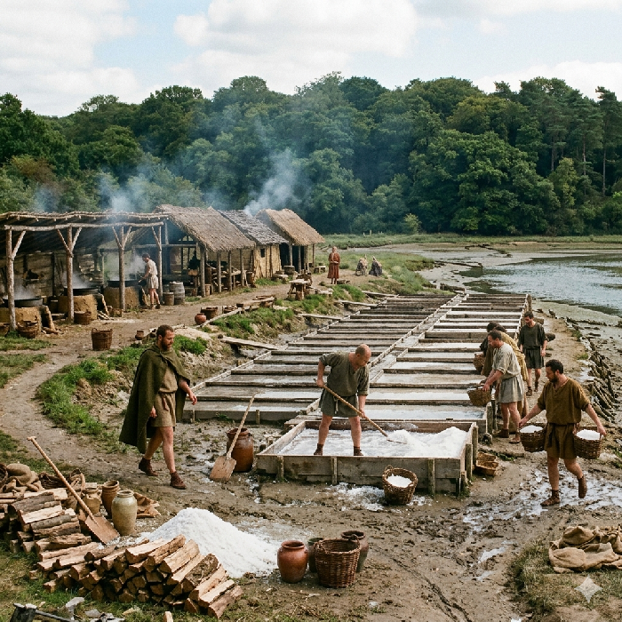 Salt was not a condiment in the Roman military economy. It was a preservation technology — the primary means by which meat, fish and other perishables were converted into the stable long-duration provisions that a fleet required. Without salt the cattle slaughtered at Beddingham could not be preserved for a voyage, the fish caught in the Glynde frames could not be stored through the winter, the eels taken from the Ouse margins could not travel further than a day's journey from where they were caught. The grain supply chain and the salt supply chain were not parallel systems. They were interdependent — one producing the food, the other making it last long enough to be useful.
The tidal geography of the Ouse flood plain provided exactly the conditions that Roman salt production required. Shallow brackish water pushed across wide flat ground by the twice-daily tide, evaporating in the wind off the Channel, leaving salt crystals on the pan surface as the water retreated — this is the mechanism, and it works only where the ground is flat enough and the water shallow enough for evaporation to outpace the tidal refill. The Ouse valley behind the Downs, at the sea levels that prevailed through the Roman and Saxon periods, offered that geography across a considerable area of tidal margin between Lewes and the coast.
Selmeston — Sælmerige stán — the brine area by the Roman milestone. No name on this page connects its industry to the Roman infrastructure more explicitly. Sælmerige is brine — salt water being processed for its salt content rather than simply tidal water passing through. Stán is a stone, here most plausibly a Roman road milestone, the kind of marker that Roman engineering placed at measured intervals along its roads as navigational and administrative reference points. A brine processing settlement located by reference to a Roman milestone is a settlement that existed within the Roman administrative system and knew it — the milestone was still the most useful way to describe where you were when the Saxon settlers arrived and needed a name for the place. Selmeston places the salt industry of the Ouse corridor not in the margins of the Roman supply system but at its measured, marked, administered centre.
Ringmer — Hring mære — the ringed settlement by the sea inlet. The mære element — a sea inlet or tidal mere — identifies the shallow tidal water that salt production requires, while the hring enclosure suggests the managed boundaries of a salt working operation, the pans defined and maintained rather than simply exploited where the tide happened to leave water standing. Ringmer sits above the Ouse tidal plain in a position that commands the shallow inlets below it, the enclosed settlement watching over the salt workings in the margin between the permanent land and the permanent water.
The Domesday record of 1086 provides the documentary confirmation that the place names alone cannot. Across the Ouse and Cuckmere tidal margins, salthouses were still operating in sufficient number to be recorded manor by manor in the survey — Laughton with sixteen, Rodmell with eleven, Ripe with eight, Beddingham with four, West Dean with four, Charlston with three. These are not new industries established after the Romans left. They are survivals — the remnant of a salt production system that was operating at considerably greater intensity in the Roman period when the fleet's demand for preservation salt was at its peak. The Domesday figures are a floor, not a ceiling. They record what was still running in 1086, not what had been running three centuries earlier when Carausius needed to preserve provisions for a Channel battle fleet.
Laughton with sixteen salthouses is the largest single producer in the corridor — more than Rodmell, more than Ripe, more than any other Ouse valley manor in the survey. Leow ton, the pig farm on the hill, controls sixteen salthouses in the marsh below it. The settlement is on the dry ground above the flood line, the industry is in the tidal margin below, and the Domesday record connects the two as a single economic unit. That pattern — the named settlement on the hill, the salt working in the unnamed marsh below — repeats across the corridor at Rodmell, Ripe and Beddingham, each one a mixed economy settlement whose name describes one activity while the Domesday record reveals another running simultaneously in the tidal margin below.
The salt produced in this corridor moved into the same river transport system that carried grain and livestock coastward to the fleet — loaded at the ham settlements at the tidal limit, transferred to coastal vessels, and delivered to Pevensey where it entered the preservation cycle that made the entire food supply chain functional. Grain without salt is food for a garrison. Grain with salt is provisions for a fleet at sea. The two supply systems together are what made Pevensey operationally viable as a naval headquarters rather than simply a defended shore position.
| | |
|---|
Industrial Materials ▲ |
|---|
|
The supply chain that fed the fleet at Pevensey was not only a food supply chain. The base itself required continuous construction and maintenance — mortar for the fort walls, pitch and tar for the hulls, lime for the plaster and the drains and the structural fabric of a permanent military installation. These materials are not provisions. They do not feed the garrison or preserve the catch. They hold the base together physically, and without them the walls crack, the hulls leak and the installation that the entire supply system exists to serve begins to fail. The Ouse corridor supplied these materials as systematically as it supplied grain and salt.
Offham — Ofen ham — the lime kiln settlement at the water's edge. The ofen element — an oven or industrial kiln — takes its specific meaning here from the landscape immediately behind the settlement. Offham sits below a massive chalk quarry, the raw material for lime burning immediately accessible on the hillside above the ham at the tidal limit. Chalk heated in a kiln to high temperature produces quicklime — calcium oxide — the essential ingredient in Roman mortar, plaster and structural concrete. Without lime there is no mortar. Without mortar the walls of Anderida are not a Roman fort but a dry stone enclosure. The construction of Pevensey around 290 AD, confirmed by dendrochronological dating of the foundation timbers, required lime in large quantities at a specific moment — the kilns at Offham burning chalk from the quarry above, the quicklime loaded onto river craft at the ham landing stage below, moving coastward to the construction site on the promontory. The settlement at the base of the quarry, named after its kilns, was burning the material that built the fort.
The connection between Offham and Pevensey is not inference from proximity alone. It is the logic of the supply chain made physical — chalk quarry above, kiln settlement at the tidal limit below, river transport from the ham landing stage to the coast, construction site at the end of the water route. Every element of that chain is present in the landscape. Offham is where it starts.
Tarring Neville — Teoru hring — the resin producing enclosed settlement. Teoru is pine resin or tar — the raw material processed into the pitch that was applied to hull planking to seal it against water ingress, caulked into the seams between strakes to prevent leaking, and painted onto the underwater surfaces of vessels hauled out for maintenance. A fleet consumes pitch continuously — every refit, every caulking, every hull inspection that finds a failing seam requires fresh pitch applied hot to a dry surface. A settlement that identifies itself by its resin production, sitting in a valley running down toward the coast, is describing a specialist industrial operation serving the shipyard at Pevensey rather than any local agricultural need.
The valley in which Tarring Neville sits may carry its industry in its geography as well as its name. Pine trees — the source of the resin that becomes tar and pitch when heated — require well-drained sandy or chalk soils of the kind that the valley sides here provide. The possibility that the Tarring valley carried managed pine woodland specifically cultivated for resin extraction connects this settlement to Penhurst on the northern edge of the Pevensey supply zone — Pín hyrst, the pine clearing in the Andredsweald — where pine was being managed in the forest to the north for the same purpose. Between Penhurst in the forest and Tarring Neville on the valley slope running toward the coast, the resin supply chain for the Pevensey shipyard may be readable in two place names separated by twenty miles of supply route. The reading is offered as a possibility rather than a conclusion, but the logic of the supply system makes it a reasonable one.
The lime from Offham and the tar from Tarring Neville served different parts of the same base. The lime went into the walls, the floors, the drains and the structural fabric of the fort and its associated buildings. The tar went onto the hulls, into the seams and across the underwater surfaces of every vessel that the shipyard at Cooden built and the refit facility at Chilley maintained. Together they represent the maintenance supply chain without which neither the fort nor the fleet could have remained operational — the materials that held the physical structure of the entire Pevensey operation together, produced in the corridor to the west and moved coastward by the same river transport system that carried grain, salt, cattle and fish to the lagoon shore.
| | |
|---|
Conclusion ▲ |
|---|
|
The landscape between the Ouse and the Cuckmere was not a scatter of independent agricultural settlements growing food for local consumption. It was a managed supply zone, organised around a single operational purpose — keeping a fleet at sea and a fort standing at Pevensey — and readable in its organisation through the names that Saxon settlers gave to what they found when the Romans had gone.
The supply system worked in vertical layers stacked between the chalk ridge and the tidal margin. On the open Downs the sheep grazed the thin dry turf that the chalk produces and nothing else replicates. On the hill slopes below, the ton settlements managed the mixed farms — grain, livestock, specialist crops — that fed both the garrison and the processing operations below them. On the clay vale the cattle worked the heavy soils, pulled the wagons and provided the leather and tallow that the shipyard consumed as steadily as it consumed timber. At the tidal limit the ham settlements received everything the hill produced and loaded it onto river craft for the final movement coastward. In the tidal margins below the hams, invisible in the settlement record but present in the Domesday salthouses and the fish frame names, the most chemically essential product of all — salt — was produced in the shallow brackish water that the twice-daily tide renewed.
The place names are the index to that system. South Malling ground the flour. Berwick grew the barley. Alciston malted it into ale. Milton diversified into millet against the hungry gap. Ripe named itself after the harvest. Mayes Farm watched over the arable zone from its hillock in the centre of the fields. Winton and Friston grazed the chalk above. Telscombe finished the wool in the dry valley below the ridge. Chalvington reared the calves on the high ground. Beddingham stalled the cattle and rested the oxen at the water's edge. Glynde set its fish frames in the tidal Ouse. South Heighton dried the catch on the hill above. Piddinghoe made floats for the nets on its river promontory. Alfriston and Rodmell fished the eels from the Cuckmere and the Ouse. Laughton, Ripe, Rodmell, Beddingham, West Dean and Charlston ran their salthouses in the tidal margins and were still running them when the Domesday commissioners counted them in 1086. Selmeston named itself after its brine workings and located them by the Roman milestone on the road. Offham burned chalk from the quarry above it into the lime that built the fort walls. Tarring Neville processed pine resin into the pitch that sealed the hulls.
Nothing in that list is incidental. Every settlement name describes a function, every function serves the supply chain, and every supply chain leads to the same destination — the lagoon at Pevensey and the fleet that operated from it. The Saxons who named these places did not invent the landscape they were describing. They inherited it, still organised, still legible, still coherent enough in its layout that the right word came naturally when they needed a name for each place in it. That coherence is itself the argument. A landscape this systematically named is a landscape that was systematically used. The fleet is gone, the lagoon is drained, the fort walls stand without their garrison. But the supply system that sustained all three is still written in the names on the map, waiting to be read in the correct sequence by anyone who knows what the words mean.
|
|
|
;)
)
)
)
)
)


