| The Original Bremenium: A Reappraisal of the Iter I Distance from Corstopitum |
|---|
| Introduction ▲ |
|---|
|
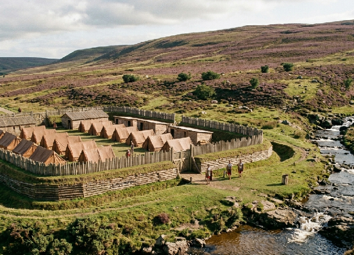
The identification of Bremenium with the Roman fort at High Rochester, Northumberland, has been accepted in Romano-British scholarship for well over a century. The fort's inscriptions name it explicitly, its visible remains are substantial, and its position on Dere Street places it firmly within the expected military geography of the northern frontier. The identification has never seriously been questioned.
Yet a fundamental problem has always existed and has never been satisfactorily resolved. The Antonine Itinerary records the distance from Corstopitum — Roman Corbridge — to Bremenium as XX Roman miles. High Rochester measures approximately 26.3 Roman miles from Corbridge along the line of Dere Street. The discrepancy of over six Roman miles has never been satisfactorily explained, and the solution universally offered — that a scribe dropped a numeral during manuscript copying — rests on no independent textual evidence whatsoever. No manuscript variant reading of XXV or XXVI exists. Every surviving copy of the Itinerary reads XX. The copying error hypothesis was constructed backwards from the assumption that High Rochester must be correct, and has been repeated ever since as though it were established fact.
This paper proposes a different solution. The Itinerary text is correct as written. The twenty-mile station on Dere Street is not High Rochester but the site now known as Old Town Farm, immediately south east of Otterburn on the west bank of the River Rede. Drawing on distance analysis, place-name etymology, landscape topography, Ordnance Survey map evidence, scheduled monument records, and the pre-Roman place-name tradition of the Otadini, ten independent strands of evidence are presented for Old Town as the original Bremenium — the settlement from which the name derived, recorded by Ptolemy as an Otadini town, and later potentially misattributed to the larger and more visible fort that developed six miles further north along Dere Street.
| | |
|---|
The Distance Problem ▲ |
|---|
|
The Antonine Itinerary takes its name from the Emperor Antoninus Pius but was not compiled during his reign. The British section, headed Iter Britanniarum in the plural, was assembled after Britain was divided into two provinces by Septimius Severus around AD 197. The version we possess in surviving manuscripts dates to the late third or early fourth century, during the reign of Diocletian, and those manuscripts themselves are medieval — the eight oldest dating to between the seventh and tenth centuries. The document is therefore not a single authored text but a compilation of official road data drawn from multiple sources spanning potentially two centuries of survey work. The underlying distance records for individual routes may be considerably older than the final compilation, reflecting survey data gathered during the Flavian and Antonine periods when the northern British road network was first being systematically measured and recorded.
This distinction matters for the argument that follows. The distance recorded in Iter I from Bremenium to Corstopitum — XX Roman miles — may not reflect the road network as it existed in the late third century. It may instead preserve an early survey figure, gathered when Old Town was the active twenty-mile station on Dere Street, before the military focus shifted northward to High Rochester during the Antonine reoccupation of Scotland in the 140s to 160s AD. The compilers of the final Itinerary, working from older source documents, copied the distances they found without updating them to reflect a station that had by then declined in importance or been superseded. The Itinerary is in this reading not wrong — it is faithfully preserving an early record that later scholarship has misread as a scribal error because the wrong station has been assumed.
The actual road distance from Corbridge to High Rochester, measured along the known and confirmed line of Dere Street, is approximately 38.9 kilometres. Converting to Roman miles this yields 26.3 — a discrepancy of 6.3 Roman miles against the Itinerary figure of 20.
This is not a minor rounding difference of the kind that arises routinely from measurement methodology, zone boundaries, or the precise point within a settlement from which distances were calculated. Such factors might plausibly account for a discrepancy of one or perhaps two Roman miles. A discrepancy of 6.3 Roman miles — more than thirty percent of the recorded distance — is of an entirely different order.
The standard scholarly response has been to propose a scribal copying error. The argument runs that the original manuscript read XXV, and that a copyist dropped the terminal V, producing XX. This is presented in the literature as the most probable explanation and has been widely repeated.
There are however two serious objections to this hypothesis which have not been adequately addressed. First, it explains the wrong discrepancy. If the correct figure were XXV — twenty-five Roman miles — the actual road distance of 26.3 Roman miles would still require explanation, leaving a residual discrepancy of 1.3 Roman miles. The copying error hypothesis does not in fact resolve the problem; it merely reduces it to a size that feels more comfortable.
Second, and more fundamentally, the hypothesis is entirely without manuscript support. The Itinerary survives in multiple manuscript copies spanning several centuries of transmission. In every surviving copy the figure reads XX. There is no variant, no marginal correction, no alternative tradition suggesting XXV or XXVI. A copying error introduced early enough to propagate through the entire manuscript tradition without leaving a single trace in any copy is not impossible, but it is a hypothesis of last resort — to be adopted only when all alternatives have been exhausted. In this case no alternative has been seriously considered, because the identification of Bremenium with High Rochester has been treated as beyond question.
Furthermore, if a copyist were to corrupt XXVI — the figure closest to the actual measured distance — to produce XX, they would need to drop two characters, VI. While single character losses do occur in manuscript transmission, the loss of two adjacent characters producing a round number is a less plausible copying pathway than the literature implies. The round number XX is precisely the kind of figure a careful copyist would be unlikely to query, which raises the possibility that it was never corrupted at all.
The question this paper asks is therefore a simple one: if we set aside the assumption that High Rochester must be correct and allow the Itinerary text to speak for itself, where on Dere Street does the twenty-mile point from Corbridge actually fall?
| | |
|---|
Old Town: Location and the Twenty Mile Measurement ▲ |
|---|
|
Approximately 29.6 kilometres north of Corbridge along the line of Dere Street — precisely the distance recorded in the Itinerary for XX Roman miles — lies the small settlement of Old Town Farm, situated on the west bank of the River Rede immediately south east of Otterburn village in Northumberland. The site sits on gently sloping ground beside the river, directly on or immediately adjacent to the confirmed line of Dere Street, in exactly the position the Itinerary requires.
The measurement is not approximate. Road distance from Corbridge to Old Town via the A68 — which follows the line of Dere Street through this section — returns a figure that converts to within a fraction of a Roman mile of the Itinerary's XX. No adjustment for copying error, no zone boundary calculation, and no special pleading is required. The Itinerary says twenty miles. Old Town is twenty miles. High Rochester is twenty-six miles.
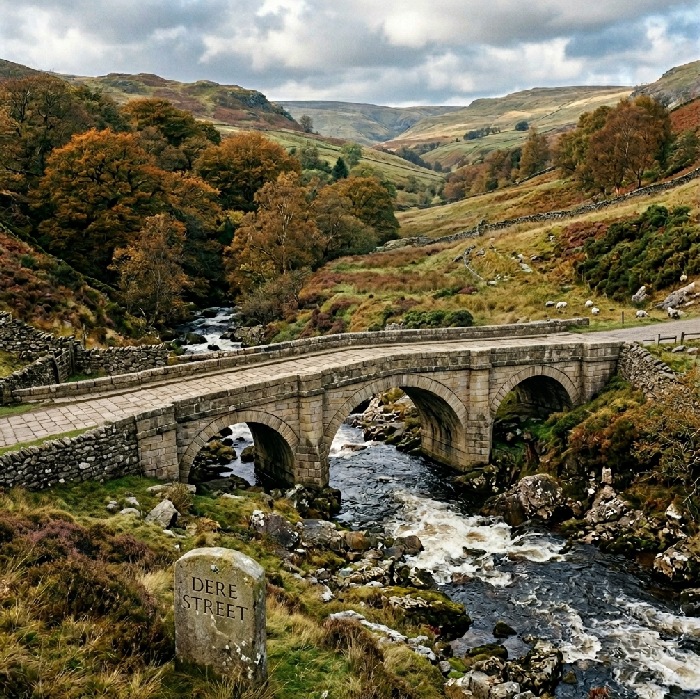
Dere Street approaches Old Town Farm from the south by crossing Miller Burn, a fast-flowing upland stream running off the moorland immediately before the settlement. The road then continues north across Dargues Burn before reaching the Dargues marching camp and pressing on to Blakehope, where it crosses the River Rede. The settlement at Old Town Farm therefore sits between two named burns on gently sloping plateau ground immediately west of the Rede — precisely the kind of sheltered, watered, accessible position that Roman road engineers selected for posting stations on Dere Street.
| | |
|---|
The Saxon Toponym: Old as a Marker of Roman Sites ▲ |
|---|
|
The place-name element ald or old in Saxon toponymy is well documented as a marker applied by Anglo-Saxon settlers to sites of significant Roman occupation. The pattern is consistent and widespread across Roman Britain. Aldborough in North Yorkshire preserves ald-burh — the old fortified place — as the Saxon name for Isurium Brigantum. Old Carlisle, Old Penrith, and Old Sarum follow the same convention, each marking a Roman predecessor remembered by the incoming population as simply the old place.
The name Old Town at the proposed site follows this convention precisely. It is not a description of a medieval settlement that has fallen into disuse — there is no evidence of a significant medieval village at this location. It is instead a Saxon topographical statement: this is where the old settlement was. When Anglo-Saxon communities applied the prefix old to a place, they were recording a visible memory of substantial earlier occupation, typically Roman, that they could see but no longer fully understand. At Old Town, that memory is of the Roman station on Dere Street at the twenty-mile point from Corbridge.
| | |
|---|
Heatherwick and the Wic Element ▲ |
|---|
|
Immediately across the River Rede from Old Town lies a feature recorded on OS maps as Heatherwick, which appears from its earthwork profile to be an Iron Age hillfort occupying the rising ground on the eastern bank. The second element of this name — wic — derives from Old English and carries the specific meaning of a specialised or dependent settlement, a trading place, or a civilian community associated with a larger centre nearby. It is the same root as the Latin vicus, which in Roman military contexts denotes the civilian settlement that grew up beside a fort to service its garrison.
The River Rede itself forms the natural boundary between Old Town on the western bank and Heatherwick on the eastern bank — not a minor burn but the main river, running fast over a rocky bed through the Redesdale valley. In the standard Roman military pattern a fort occupied a defensible position while its associated vicus developed on adjacent ground, often separated from the military zone by a natural feature. Here the Rede performs that function precisely, providing a clear physical boundary between the Roman station on the western bank and the hillfort and native civilian community on the eastern bank.
The co-occurrence of old at Old Town and wic at Heatherwick, separated by the River Rede, preserves in fossilised Saxon form the paired memory of a Roman military installation and its associated civilian settlement. The two place-names together encode what the landscape contained: a fort on one bank, a vicus on the other, divided by the river that gave the whole place its Brittonic name.
| | |
|---|
The Romano-British Farmstead ▲ |
|---|
|
The Scheduled Monuments record for Northumberland includes a Romano-British farmstead on Wood Hill, located 800 metres north-west of Old Town Cottages, Otterburn. This scheduled monument confirms Roman period activity in the immediate vicinity of the proposed site. Romano-British farmsteads of this type are typically associated with the civilian agricultural hinterland of a road station or fort, providing food, labour, and services to the military installation nearby. Their presence 800 metres from Old Town is consistent with the standard pattern of civilian settlement clustering around a Dere Street posting station, and provides physical archaeological confirmation that the Roman period landscape in this precise area was occupied and active.
| | |
|---|
Tofts Burn, Miller Burn and the Settlement Icons ▲ |
|---|
|
Ordnance Survey mapping of the Old Town area records two named watercourses running beside Old Town Farm — Tofts Burn and Miller Burn. The name Tofts Burn is particularly informative. Toft is a Norse and Saxon term denoting a homestead plot or the curtilage of a dwelling — the organised ground immediately surrounding a settled building. Tofts Burn is therefore not a natural landscape name but a name describing organised human occupation beside a watercourse: the burn by the settlement plots. This is precisely the kind of minor toponym that accumulates around a site of prolonged, structured habitation rather than casual or transient activity.
The same OS mapping shows two settlement icons in close proximity at Old Town — the standard cartographic symbol for recorded archaeological features indicating human occupation. Two settlement symbols in close proximity on either side of the burns, is consistent with the paired fort-and-vicus pattern already suggested by the Old Town and Heatherwick place-names. These are not isolated finds but spatially organised features pointing to a structured Roman period landscape at exactly the twenty-mile point on Dere Street.
| | |
|---|
The Dargues Marching Camp ▲ |
|---|
 A Roman temporary marching camp at Dargues, immediately north of Dargues Burn and south of Old Town on Dere Street, is a scheduled monument. The camp is rectangular in the standard playing-card plan, oriented north-east to south-west with four gated sides, and sits on a gently sloping plateau immediately to the west of Dere Street. Dargues Burn flows past the camp outside its south-eastern defences.
Roman marching camps mark where armies halted overnight on the road. They are not placed randomly but cluster around known safe points — water sources, established stopping distances, and permanent installations. The Dargues camp, positioned immediately adjacent to Old Town on the confirmed line of Dere Street, places significant Roman military activity at precisely the location proposed as the twenty-mile station. Armies moving north from Corbridge would reach this point after a standard day's march and halt here. The permanent installation at Old Town would provide the supply, water, and administrative infrastructure that a marching camp requires in proximity. The clustering of the Dargues camp around Old Town rather than around High Rochester — six miles further north — is consistent with Old Town being the primary road station at this point on Dere Street.
| | |
|---|
Miller Burn: The Roaring Stream ▲ |
|---|
 The name Bremenium is Brittonic in origin and translates consistently as the place of the roaring stream. This is not a decorative or incidental element of the name — in the Brittonic place-name tradition, settlements were routinely identified by the most prominent geographical feature of their immediate landscape as experienced by a traveller approaching along the road. The roaring stream is the defining characteristic of the place called Bremenium.
Dere Street, moving north from Risingham, crosses Miller Burn immediately before reaching Old Town Farm. Miller Burn is therefore the watercourse that a traveller on the road would hear and cross in the final approach to the settlement — the geographical event that announces arrival at the station. In the Brittonic naming tradition this is precisely how a place receives its name: from the feature encountered on approach, the thing that marks the threshold of the settlement. The burn crossed to reach Old Town is Miller Burn, a fast-flowing upland stream running off the moorland — exactly the roaring character that the Brittonic root describes.
High Rochester, by contrast, sits on an exposed ridge with the ground falling steeply away to north and west. The nearest watercourse, the Sills Burn, is visible across the valley but is not immediately adjacent to the fort and is not crossed by Dere Street on approach to the site. Naming a high exposed hilltop fort after a stream visible in the distance across open ground is without parallel in the Brittonic place-name tradition. The name Bremenium simply does not fit the topography of High Rochester. It fits Old Town precisely.
| | |
|---|
A Densely Occupied Otadini Landscape ▲ |
|---|
|
Ptolemy, writing in the mid-second century AD and drawing on sources probably dating to the Agricolan campaigns of the late first century, records Bremenium as a town of the Otadini — the Brittonic tribe occupying the territory of south-east Scotland and north-east England between the Firth of Forth and the River Tyne. This identification has important implications that have not been adequately integrated into the debate about Bremenium's location.
If Bremenium was an Otadini town — a native settlement predating or contemporary with early Roman activity — then its name is a pre-Roman Brittonic place-name describing a feature of the native landscape. It was not named by the Romans. It was named by the Otadini people who lived there, and the Romans adopted the existing name as they routinely did across Britain.
The landscape around Old Town and Otterburn is not an isolated upland with a single native settlement. It is a densely occupied Otadini tribal landscape with multiple defended settlements clustered around the Rede valley and its crossing points. Heatherwick hillfort occupies the eastern bank of the Rede directly opposite Old Town. Fawdon Hill hillfort (EN0588), a univallate defended settlement commanding extensive views over the valleys of the Rede, Otter and Girsonfield Burns, lies approximately 1.1 kilometres north-east of Otterburn on the same eastern bank. Colwell Hill Camp (EN0587) lies a further 940 metres to the south-east. Three hillforts in close proximity, all on the eastern bank of the Rede, all commanding the valley and its approaches, constitute a significant concentration of native Otadini settlement activity focused precisely on this stretch of the river.
This was not a remote empty upland. It was a tribal centre — a place of established population, defended settlement, and territorial significance long before Agricola's forces moved north along what would become Dere Street. When the Roman army reached this point on their march, they encountered not an empty landscape but a thriving Otadini community organised around the river crossing, the hillforts on the eastern bank, and the flat ground on the western bank where Dere Street would run. The name the Otadini used for this place — Bremenium, the place of the roaring stream — was already established. The Romans adopted it for their station at Old Town, as they adopted existing native names at hundreds of locations across Britain.
| | |
|---|
High Rochester: A Secondary Bremenium ▲ |
|---|
|
The inscriptions at High Rochester naming it Bremenium are genuine, well-attested, and not in dispute. This paper does not argue that High Rochester was not called Bremenium — it argues that it was not the original Bremenium, and that it is not the Bremenium recorded in the Itinerary at XX miles from Corstopitum.
The transfer of place-names along a road corridor is well documented in Roman Britain. Derventio appears at multiple points along the River Derwent. Cambodunum occurs more than once. Place-names moved with armies, with administrative convenience, and with the simple human habit of applying a familiar name to a new location that serves the same function. High Rochester, as the principal permanent fort in this section of Dere Street from the second century onward, would naturally have absorbed the name of the earlier station to its south — particularly as the military focus shifted northward and the original twenty-mile station at Old Town declined in importance or was reduced to a minor waypoint. By the time the Itinerary was compiled in its final form, High Rochester was the dominant installation and the name Bremenium had become firmly associated with it in official and epigraphic use. The original station at Old Town retained its identity only in the Saxon place-names that preserved its memory — Old Town, Heatherwick, Tofts Burn — long after the Roman roads fell silent.
It is also worth noting that the topography of High Rochester, while commanding and defensible, is entirely inconsistent with the meaning of the name it bears. A high exposed ridge fort is not the place of the roaring stream. The name arrived at High Rochester as a transfer from the original settlement six miles to the south, where Miller Burn still runs fast over its rocky bed across the line of Dere Street, exactly as it did when the Otadini first gave this place its name.
| | |
|---|
Conclusion ▲ |
|---|
|
Ten independent strands of evidence converge on Old Town, Otterburn as the original Bremenium of the Antonine Itinerary.
The precise distance of XX Roman miles from Corstopitum, matching Old Town exactly and falling six miles short of High Rochester. The copying error hypothesis offered to bridge this gap has no manuscript support, fails to resolve the full discrepancy, and requires the loss of two characters rather than one if the original figure was XXVI.
The Saxon old toponym at Old Town, following the well-documented pattern of ald as a marker of Roman sites across Britain, from Aldborough to Old Carlisle to Old Sarum.
The wic element at Heatherwick on the eastern bank of the Rede, preserving the Saxon memory of the civilian vicus associated with the road station, separated from Old Town by the river itself.
The scheduled Romano-British farmstead 800 metres distant, providing physical archaeological confirmation of Roman period activity in the immediate landscape.
The settlement place-names Tofts Burn and Miller Burn encoding organised human occupation beside the watercourses at Old Town.
The two OS settlement icons in close proximity at the site, consistent with the paired fort-and-vicus pattern suggested by the place-name evidence.
The Dargues marching camp clustering at the twenty-mile point immediately adjacent to Old Town rather than at High Rochester six miles further north.
Miller Burn as the roaring stream of Bremenium — the watercourse crossed by Dere Street immediately before reaching the station, in direct contrast to the distant and unrelated Sills Burn at High Rochester.
The densely occupied Otadini tribal landscape around Old Town and Otterburn, with three hillforts — Heatherwick, Fawdon Hill and Colwell Hill Camp — clustered on the eastern bank of the Rede commanding the valley and its crossings, confirming this as a place of established native significance long before the Roman road was built.
And Ptolemy's identification of Bremenium as an Otadini town — a pre-Roman native settlement named by its inhabitants for the stream they crossed every day — which makes Old Town, beside Miller Burn on the western bank of the Rede, the geographically and linguistically coherent original.
No single strand would be sufficient. Together they form a mutually reinforcing case that is very difficult to explain away. The standard alternative demands the invention of a copying error for which no manuscript evidence exists, which does not even resolve the full distance discrepancy, and which requires the scholarly community to have been wrong about the most basic geographical requirement of the place-name itself — that Bremenium, the place of the roaring stream, should actually be beside a roaring stream.
The Itinerary text reads XX. Old Town is XX Roman miles from Corbridge. High Rochester is not. The simplest explanation is that the text is correct, and that Old Town, Otterburn preserves in its name, its landscape, its burns, and its surrounding hillforts the memory of the original Bremenium — the place of the roaring stream — that Ptolemy recorded as an Otadini town and the Roman army adopted as its twenty-mile station on the long road north.
Geophysical survey and targeted excavation at Old Town Farm would be required to confirm this hypothesis archaeologically. The convergence of evidence presented here suggests that such investigation is long overdue.
| | |
|---|
Links to other Roman Documents ▲ |
|---|
|
The pages below show links to documents that reference pages concerning the Roman Occupation.
For the individual pages please click on the links, new documents will be auto populated as and when these
are written.
| |
|
|
;)


)
)