| Roman Fortifications |
|---|
| |
|---|
Different type of Roman Fortifications and their names |
|---|
On this page we will show a summary of the different types of Roman Military Fortifications, our information comes from the archaelogy of Hadrians wall and the European Limes.
The European Limes are a fortified Roman border stretching from Katwijk Brittenburg in the Netherlands, through Germany, Austria, Switzerland, Liechtenstein, Slovakia, Hungary ending in Halmyris in Romania on the Black Sea coast.
These defenses which stretch across the Rhine and Danube were nearly 2800 kilometers in length and were primarily made of 9ft wooden stakes with watchtowers, castellum, burgus and castra dotted along the western border of the main rivers.
They were designed to stop incursions into Roman controlled areas, and to allow taxes on goods to be collected at major crossing points.
| Castra (The Legionary Fortress / Large Fort) |
|---|
 Wikipedia Definition:
(Wikipedia Page for more details);
Wikipedia Definition:
(Wikipedia Page for more details);
'In Latin usage, the singular form castrum meant 'fort', while the plural form castra meant 'camp'. The singular and plural forms could refer in Latin to either a building or plot of land, used as a fortified military base.'
'Regulations required a major unit in the field to retire to a properly constructed camp every day. "… as soon as they have marched into an enemy's land, they do not begin to fight until they have walled their camp about; nor is the fence they raise rashly made, or uneven; nor do they all abide ill it, nor do those that are in it take their places at random; but if it happens that the ground is uneven, it is first levelled: their camp is also four-square by measure, and carpenters are ready, in great numbers, with their tools, to erect their buildings for them. To this end a marching column ported the equipment needed to build and stock the camp in a baggage train of wagons and on the backs of the soldiers.'
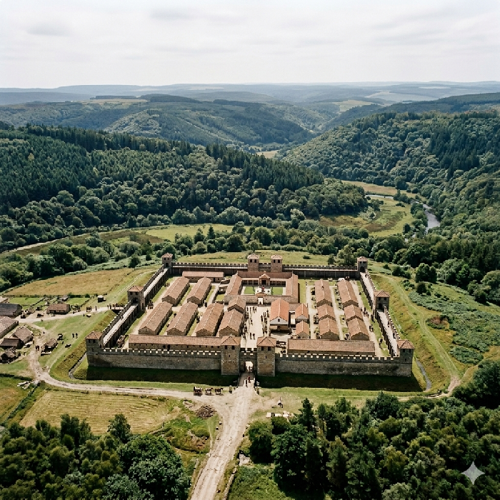
Originally referring to a temporary marching camp, castra became the definitive term for permanent, large-scale military bases. These housed full legions of around 5,000 to 6,000 men, or large auxiliary regiments of comparable strength. They were essentially stone or turf cities, complete with standard internal grids, a headquarters building (principia), the commander's house (praetorium), granaries, and bathhouses. In England, castrum/castra became the source of place name elements such as caister, caistor, caster, castor, cester, chester and eter, derived via the Saxon cæster, typically indicating a major Roman fort together with its surrounding vicus (supporting town). British examples include Chester (Deva), York (Eboracum), and Caerleon (Isca).
| | |
|---|
Castellum (The Auxiliary Fort) |
|---|
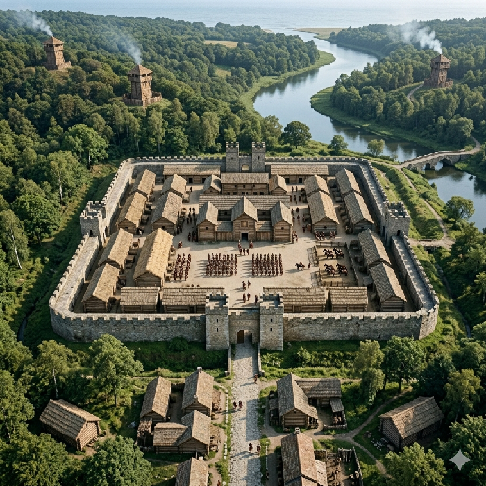 Castellum is the diminutive form of castrum and is the direct ancestor of the modern English word "castle." It denotes a smaller, standard-sized fort or fortlet designed to house an auxiliary cohort or cavalry wing, ranging from 500 to 1,000 troops, or irregular auxiliary units of non-citizen troops known as numeri. Castella were the backbone of frontier control — found at regular intervals along Hadrian's Wall and positioned strategically along major trunk roads throughout Wales and northern Britain to secure lines of communication.
Place names beginning with Castle- generally derive from castellum, while names ending in -castle are more typically of Norman origin — though this is a tendency rather than a hard rule. The Saxons appear to have adopted the word freely as a general term for any visible Roman fortification, which makes precise attribution difficult. A further complication is that the Normans themselves often planted their castles on or immediately adjacent to existing Roman defensive positions. Bodiam Castle is a likely example of this pattern — sited to control the northern bank of the Rother, commanding both the causeway crossing of Margary 13 and the approach to the extensive iron-working complex of the Brede valley.
| | |
|---|
Burgus (The Late Roman Small Fort / Supply Post) |
|---|
 Wikipedia Definition:
(Wikipedia Page for more details)
Wikipedia Definition:
(Wikipedia Page for more details)
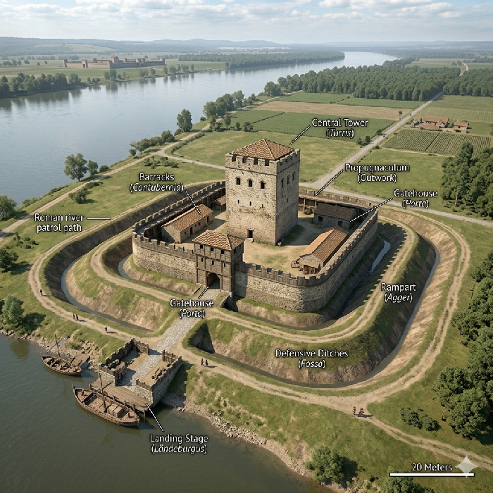
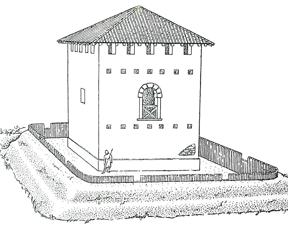
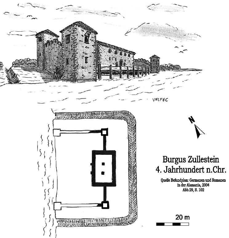
The term burgus, derived from a Germanic or Greek loanword, became prominent in the Late Roman Empire of the 3rd and 4th centuries AD. Much smaller than a castellum, a burgus was a compact, heavily fortified outpost — typically a stout central tower enclosed by a fortified wall and ditch.
They were explicitly logistical and defensive nodes, built along vital riverways, estuaries, and major highways. They did not house armies; instead small detachments of guards (burgarii) secured supply depots, collected taxes, protected river crossings, and kept heavy freight moving safely through difficult terrain such as the Andredsweald. A specialised variant, the burgus with river landing (Ländeburgus), incorporated crenellated walls extending to the riverbank like pincers, protecting a berthing bay for cargo ships and patrol boats — a pattern potentially relevant to the Cadborough location near Rye, at the strategic head of the River Brede.
The modern place name element Borough derives from burgus; the distinct elements Burgh and Burg could derive from Burgus but may derive instead from the Saxon beorg, meaning a hill.
Click on the images for the full Wikipedia image:
| Specula / Turris (The Watchtower) |
|---|
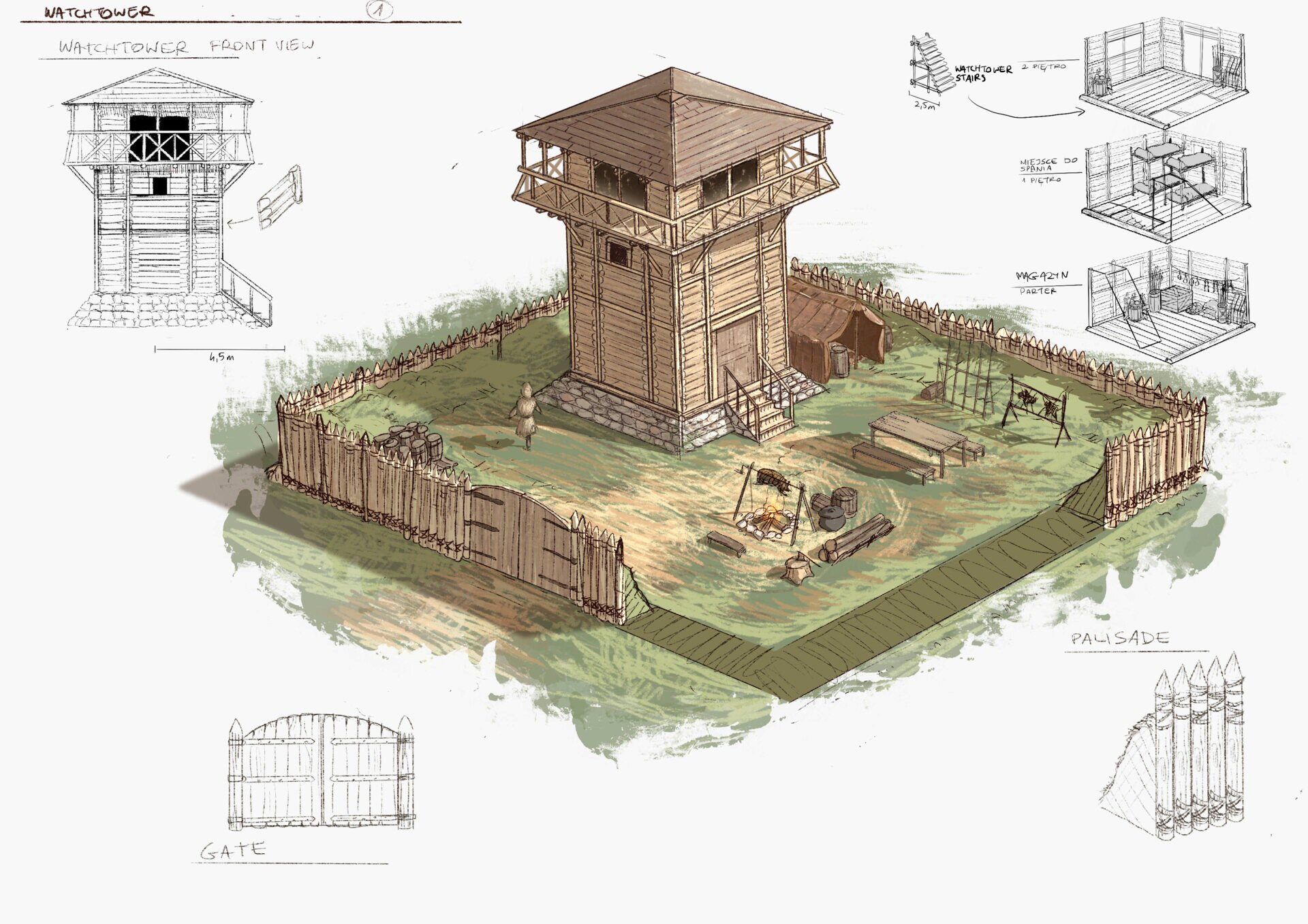
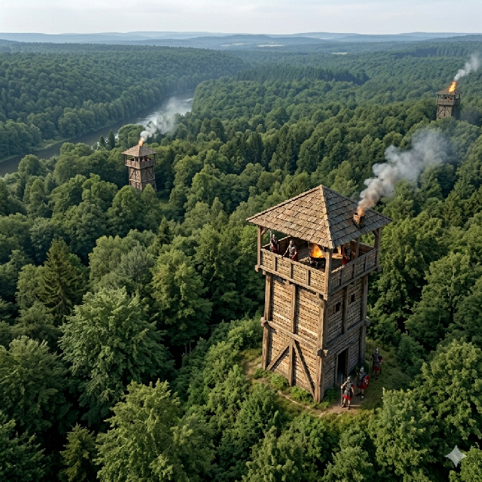 Pure watchtowers were termed speculae (lookout posts) or turres (towers) in Roman usage. These were minimalist vertical structures, either timber or stone, housing only a handful of lookouts. They had no offensive capability whatsoever — their entire function was early warning and communication. Placed on prominent high spots, headlands, or at regular intervals between larger forts, they used smoke by day and fire by night to relay tactical intelligence across vast distances within minutes. In the Andredsweald area, the proximity of dense forest meant the majority would have been timber-built. The typical dimensions were approximately 3.5 metres × 3.5 metres in plan and 7.5 metres tall, surrounded by a ditch of around 12 metres × 12 metres with a 2-metre palisade fence on top of the bank, with a detachment of 8 to 10 men.
The Saxons appear to have adopted the term Castle in place names freely as a general term for any visible Roman fortification, which makes precise attribution difficult. A further complication is that the Normans themselves often planted their castles on or immediately adjacent to existing Roman defensive positions. Bodiam Castle is a likely example of this pattern — sited to control the northern bank of the Rother, commanding both the causeway crossing of Margary 13 and the approach to the extensive iron-working complex of the Brede valley.
The image below is a really excellent visualisation of a small wooden watchtower, which would have had a detachment of 8-10 men.
Click on the image below for the original website and larger image:
| | |
|---|
Conclusion |
|---|
|
It would seem that four distinct Latin terms were used for Roman military sites, broadly implying a hierarchy of size and function:
- Castra — large permanent bases for legions or major auxiliary units
- Castellum — smaller auxiliary forts housing cohorts or cavalry wings, forming the backbone of road and frontier control
- Burgus — compact late-Roman fortified posts, typically logistical in function, guarding river crossings, supply routes and tax points
- Specula / Turris — timber or stone watchtowers spaced at approximately Roman mile intervals for signalling and early warning
In our area of East Sussex, full castra are rare. Hastings Ceastre, mentioned in the Burghal Hidage, preserves a Roman place name even if the Saxon-period record is later, and the fort of Anderida at Pevensey is the clearest surviving example.
We have identified only one likely burgus — at Cadborough Cliffs near Rye, at the strategic mouth of the River Brede. Its position controlling river access makes it a strong candidate for a Ländeburgus of the type illustrated above at Burgus Zullstein.
Possible castellum locations survive in place names beginning with Castle- — Castleham being a slight variation — typically in strategic positions on or near major Roman roads. These may represent more substantial, possibly stone-built structures that coordinated the surrounding watchtower network.
The watchtowers themselves would have been timber-built, drawing on the vast resources of the Andredsweald. Although no surface traces survive, their surrounding ditches may still be detectable on LiDAR.
One further point of interest: the Romans referred to the River Rother as the Limen. In Saxon this could derive from lǽmen meaning "earthen," but a more compelling possibility is that it preserves the Latin directly — limen meaning "threshold" or "boundary of the military zone." The related Latin limes carries the same sense of limit or frontier, raising the intriguing possibility that the Rother itself functioned as a formal limes — a recognised military boundary of Roman Britannia.
|
|
|
|
;)
)
)
)
)
)
)