| Anglo Saxon Chronicles - 527AD - Cerdicesleigh (Cerdic and Cynric) |
|---|
| The entry from the Chronicles |
|---|
Original text
Her Cerdic ⁊ Cynric fuhton wiþ Brettas in þære stowe þe is gecueden Cerdicesleaga.
Translation
527AD. This year Cerdic and Cynric fought with the Britons in the place that is called Cerdicesleigh (Lee).
| Where might it be |
|---|
Cerdicesleigh this is made up of two snippets 'Cerdic's' meaning owned by Cerdice and 'leigh' from the Saxon 'leah' - 'A lea, meadow, open space' hence becomes 'Cerdices meadow', but over time Cerdic was dropped and it just became Lee. This Battle was most likely to have been on the roman road from the South West where it crosses the river Test.
A lot of names in this area are derived from Cerdic's name, this includes Itchenor, the river Itchen (which was probably the early boundary of Cerdic and Cynric kingdom).
The expansion of the West Saxons seems to have generally North West, and they first take Natanleods land from Netley up to Shawford, all along the Itchen River. They then take Shawford and defeat the defenders of Chichester.
This battle at Lee seems to have been an attempt by the Briton to take Chichester from the South West, but was stopped at Lee on the river crossing, and the Britons were driven back, this appears to give the Wessex Saxons control of the New Forest.
| | |
|---|
Possible interpretation of the Chronicles |
|---|
My location at Lee is because Margary when plotting the M22 road from Otterbourne to the New Forest could not find the road around Nursling, and assumed it went straight across the River Test to Calmore, however with the water at 4.5 metres then a more northern route through Lee would be more likely as the Romans didn't like building across tidal areas. This northern route would have been from Winsor to Wade Hill then Lee.
This battle at Cerdicesleigh (Lee) seems to have allowed the West Saxons to take control of the New Forest area of Southern Hampshire.
| Map showing the Battles of Cerdic, Cynric and the West Saxons |
|---|
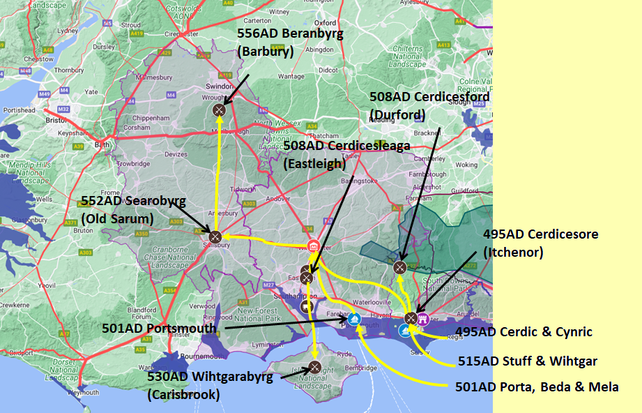
Map generated using Google My Maps 2024 - showing the Landscape, modern Counties and sea in 477AD
Please Note: this map is my interpretation of the Anglo Saxon Chronicles entries relating to Cerdic, Cynric and the West Saxons and their take over of Hampshire, the thin purple line shows the modern Hampshire boundary.
The logic for the coastal changes and the Forest of Andredsweald can be viewed on the following pages:
Roman Roads in Britain
Anglo Saxon Chronicles - 892AD - The Great Oak Forest of Andredsweald
The Variable Ocean: Was the high tide level in Saxon times at Pevensey at about 4.5 metres ?
The Variable Ocean: Was the high tide level in Saxon times in the Wash 4 to 5 metres higher ?
Landscape - The History of the Romney Marsh in maps
The Variable Ocean: Roman Locations that have not been identified and roads that just terminate
|
|
|
;)


