| Anglo Saxon Chronicles - 491AD - Andredescester
(Ælle,Cymen, Wlenca and Cissa) |
|---|
| The entry from the Chronicles |
|---|
|
Original text
Her Ælle, Cissa ymbsæton Andredescester, ofslogon alle þa þe þærinne eardedon; ne wearþ þær forþon an Bret to lafe.
Translation
491AD. Ælle and Cissa besieged Andredescester, near Pevensey, and slew all who dwelt therein, so that not one Briton was left alive.
(Source: Parker Chronicle, MS Corpus Christi College Cambridge 173)
| | |
|---|
Further Details |
|---|
|
Anderida was the Roman name for the massive Saxon Shore fort at Pevensey, built in the late third or early fourth century AD. Andredescester is the Saxon name for the same place, combining two Old English elements: Andredes-, referring to Andredsleage — the vast oak forest covering the Weald of Kent and Sussex, known later as Andredsweald — and -cester, derived from the Latin castra, meaning a Roman fortified settlement. It is the same root found in Chester, Colchester, Caistor and many other English place names. The name therefore means roughly "the fort at the edge of the forest of Andredsleage."
Where the Chronicles refer to the 'Welsh' or Britons, the Old English word used is Wealh (plural Wealas), which the Saxons applied to the Romano-British population they were displacing. It carries a sense of "foreigner" and is the same word that gives us Wales and walnut. It does not refer to the modern Welsh people, but to the Britons of southern and eastern England.
The South Saxons appear to have consolidated their western boundary at Chichester — the old Roman fortified city — before pushing east to remove the remaining British resistance south of Andredsweald. From the distribution of place names containing the element -ing, it appears they advanced along the Adur valley and the old Roman roads north of the South Downs, pushing the Britons steadily eastward. There is evidence of resistance near Plumpton and Barcombe before the survivors were cornered on the Pevensey peninsula. The fort of Anderida stood on what was then a tidal peninsula — possibly barely more than an island — surrounded by coastal marshes and shallow inlets, since sea levels in 491AD were substantially higher relative to the land than they are today. This made the fort both difficult to assault and, once surrounded, impossible to escape from.
| | |
|---|
Possible interpretation of the Chronicles |
|---|
|
The Chronicle's language — "not one Briton was left alive" — is stark, and may carry a rhetorical element, emphasising total victory rather than necessarily describing a universal massacre to the last man. Nevertheless, the entry marks the end of any organised British presence within the South Saxon kingdom.
It is significant that Ælle's expansion eastward stopped at Pevensey and did not extend further along the coast. This was not simply a matter of military exhaustion — the territory east of the Pevensey marshes was already occupied by the Haestingas, a distinct Saxon people who controlled East Sussex independently of Ælle's South Saxon kingdom.
The Haestingas held the land around the eastern shore of the marshes and the heavily wooded ridges beyond, including the area around Ashburnham, which was an important centre of iron working and shipbuilding supported by the abundant timber of the Andredsweald. Pevensey therefore represented a natural and politically determined boundary: Ælle had pushed as far east as he could without encroaching on Haestingas territory.
The 491AD entry is among the last Chronicle references to Ælle as an active military leader. After Anderida, he disappears from the historical record entirely. Bede, writing in the early eighth century, names him as the first of the southern English kings to hold overlordship — bretwalda — over the other Anglo-Saxon kingdoms south of the Humber, which suggests his power at its height extended well beyond Sussex. Whether he died shortly after 491AD or simply ceased to be recorded is unknown. The kingdom he founded survived, with interruptions, until its absorption into Wessex in the ninth century.
| | |
|---|
Map showing the Battles of Aelle, Cymen, Wlencing & Cissa |
|---|
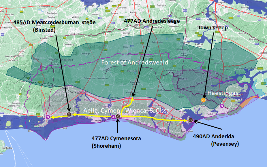
Map generated using Google My Maps 2024 - showing the Landscape, modern Counties and sea in 477AD
Please Note: this map is my interpretation of the Anglo Saxon Chronicles entries relating to Aelle, Cymen, Wlencing & Cissa and their take over of Sussex, the thin purple line shows the modern Sussex boundary.
Aelle controlled West Sussex up to Andredsweald, and the Haestingas controlled East Sussex both of these areas are shaded in light purple.
The logic for the coastal changes and the Forest of Andredsweald can be viewed on the following pages:
Roman Roads in Britain
Anglo Saxon Chronicles - 892AD - The Great Oak Forest of Andredsweald
The Variable Ocean: Was the high tide level in Saxon times at Pevensey at about 4.5 metres ?
The Variable Ocean: Was the high tide level in Saxon times in the Wash 4 to 5 metres higher ?
Landscape - The History of the Romney Marsh in maps
The Variable Ocean: Roman Locations that have not been identified and roads that just terminate
|
|
|
;)


