| Anglo Saxon Chronicles - 495AD - Cerdicesora
(Cerdic and Cynric) |
|---|
| The entry from the Chronicles |
|---|
Original text
Her cuomon twegen aldormen on Bretene, Cerdic ⁊ Cynric his sunu, mid .v. scipum in þone stede þe is gecueden Cerdicesora ⁊ þy ilcan dæge gefuhtun wiþ Walum.
Translation
495AD. This year came two leaders into Britain, Cerdic and Cynric his son, with five ships, at a place that is called Cerdicesora. And they fought with the Welsh the same day. Cerdic died this year, possibly from injuries sustained in the battle, and Cynric took over.
| Where might it be |
|---|
|
Cerdicesora breaks into two elements: Cerdices (Cerdic's — the possessive form of the leader's name as recorded in the Chronicles) and ora (shore, landing place). So the meaning is simply 'Cerdic's shore', commemorating the specific landing recorded in the Chronicles with a date. This is one of the rare cases where a personal name appears in a Saxon place name — but it records a historical event, not an ownership claim in the ordinary sense.
The name evolution runs as follows. With the original meaning lost, Cerdices at the front erodes, leaving Icesora. The ending ora softens to ore, giving Icenore at Domesday, and finally Itchenor today. Each step is a small and natural phonetic change; the chain as a whole is consistent and coherent.
| | |
|---|
Conclusion |
|---|
|
Itchenor in West Sussex is the most geographically convincing identification for Cerdicesora. It sits at the western edge of what was then Ælle's Sussex territory — Chichester had been taken after the battle of Mearcrædesburnan stæðe in 485AD — making Itchenor the natural westward limit of Saxon-held coastline at the time. Landing here, Cerdic and Cynric were not entering hostile Sussex but pushing beyond it into what would become Hampshire and ultimately Wessex. The location fits the Chronicle's narrative of a progressive westward colonisation of the south coast exactly.
As with Cymensora and Shoreham, the significance of the identification is not just geographical but linguistic. The modern name Itchenor carries within it, compressed and worn smooth by fifteen centuries of use, the name of the West Saxon founder and the memory of the day he came ashore. It is one of the oldest datable place names in England.
| | |
|---|
Map showing the Battles of Cerdic, Cynric and the West Saxons |
|---|
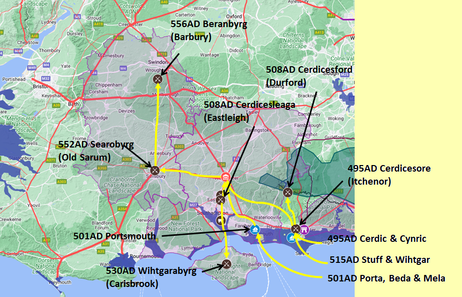
Map generated using Google My Maps 2024 - showing the Landscape, modern Counties and sea in 477AD
Please Note: this map is my interpretation of the Anglo Saxon Chronicles entries relating to Cerdic, Cynric and the West Saxons and their take over of Hampshire, the thin purple line shows the modern Hampshire boundary.
The logic for the coastal changes and the Forest of Andredsweald can be viewed on the following pages:
Roman Roads in Britain
Anglo Saxon Chronicles - 892AD - The Great Oak Forest of Andredsweald
The Variable Ocean: Was the high tide level in Saxon times at Pevensey at about 4.5 metres ?
The Variable Ocean: Was the high tide level in Saxon times in the Wash 4 to 5 metres higher ?
Landscape - The History of the Romney Marsh in maps
The Variable Ocean: Roman Locations that have not been identified and roads that just terminate
|
|
|
;)


