| Anglo Saxon Chronicles - 568AD - Wibban dune (Ceaulin and Cuþa) |
|---|
| The entry from the Chronicles |
|---|
Original text
Her Ceaulin 7 Cuþa gefuhton wiþ Ęþelbryht. 7 hine in Cent gefliemdon, 7 tuegen aldormen on Wibban dune ofslogon, Oslaf 7 Cnebban.
Translation
568AD. Here Ceaulin and Cuþa fought against Ęþelbryht, and pursued him into Kent. And they slew two aldermen at Wibban dune [Wimbledon], Oslaf and Cnebban.
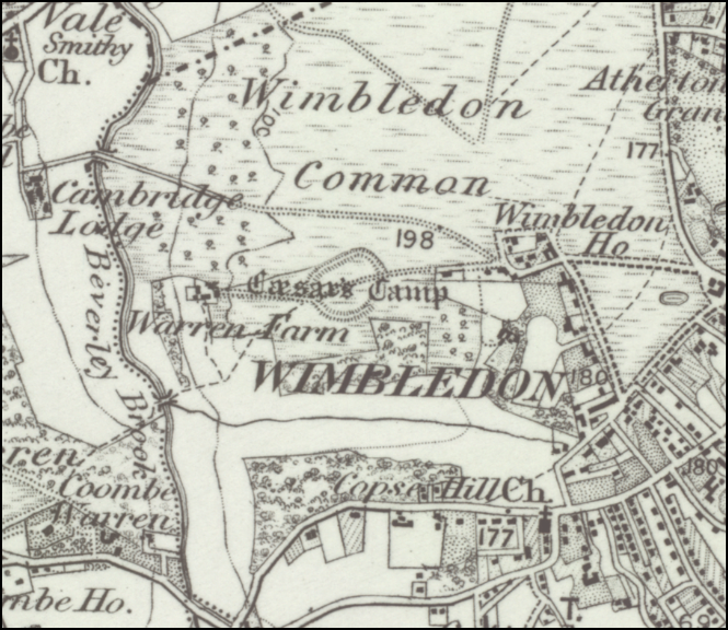
| Where is Wibban dune |
|---|
Wibban dune appears to be made from three Saxon snippets 'Wibba' meaning 'beetle', 'en' meaning 'the people of' and 'dune' an old Celtic hillfort fort, so the 'the people of the beetle fort', this probably relates to an old hillfort on Wimbledon Common now called Caesars Camp, which would have controlled the Surrey area.
This can be found at latitude longitude pair of 51.4256, -0.24122
| Possible interpretation of the Chronicles |
|---|
This move towards Kent was probably to the modern Kent boundary, and most likely the Wessex Saxons took over London from the Kings of Kent.
This would give Wessex control of modern Surrey and London.
| Map showing the Expansion of the Wessex Saxons from Beranbyrg until 628AD |
|---|
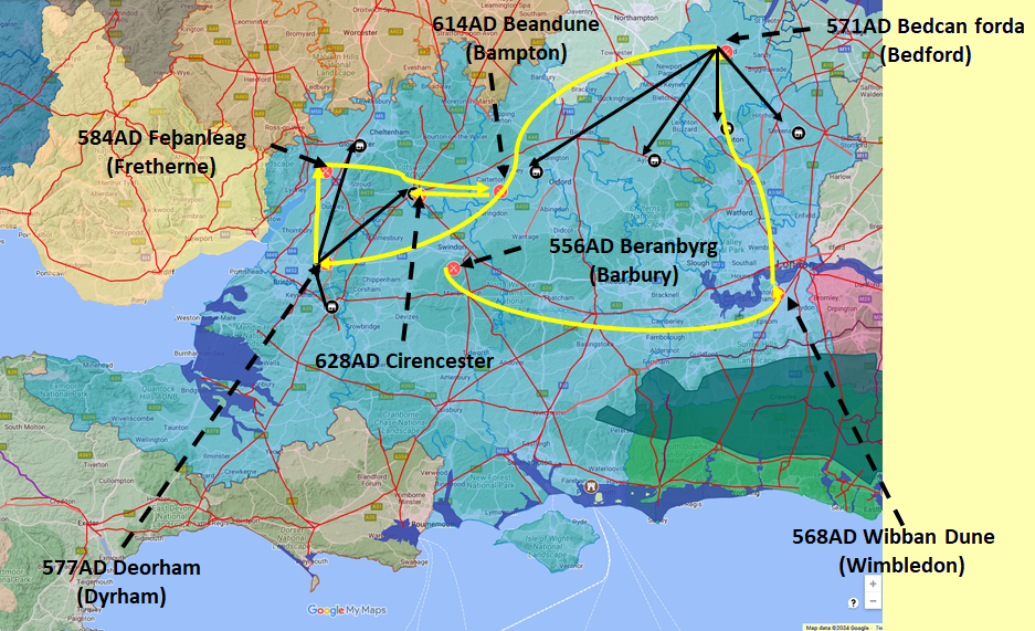
Map generated using Google My Maps 2024 - showing the Landscape, modern Counties and sea in 477AD
Please Note: this map is my interpretation of the Anglo Saxon Chronicles entries relating to the West Saxons expansion and their take over of Surrey, London, Middlesex, Hertfordshire, Bedfordshire, Buckinghamshire, Oxfordshire, Somerset and Gloucestershire.
The logic for the coastal changes and the Forest of Andredsweald can be viewed on the following pages:
Roman Roads in Britain
Anglo Saxon Chronicles - 892AD - The Great Oak Forest of Andredsweald
The Variable Ocean: Was the high tide level in Saxon times at Pevensey at about 4.5 metres ?
The Variable Ocean: Was the high tide level in Saxon times in the Wash 4 to 5 metres higher ?
Landscape - The History of the Romney Marsh in maps
The Variable Ocean: Roman Locations that have not been identified and roads that just terminate
|
|
|
;)


