| Anglo Saxon Chronicles - 556AD - Beranbyrg (Cynric and Ceawlin) |
|---|
| The entry from the Chronicles |
|---|
Original text
Her Cynric ⁊ Ceawlin fuhton wiþ Brettas æt Beranbyrg
Translation
556AD. This year Cynric and Ceawlin fought with the Britons at Beranbyrg.
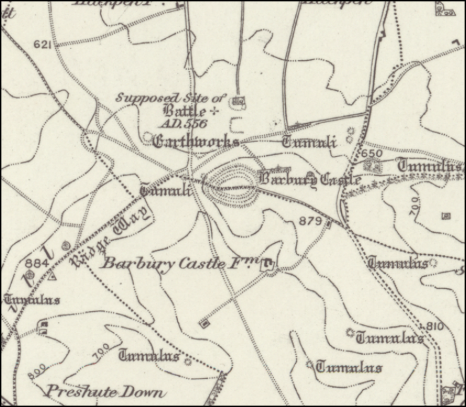
| Where is Beranbyrg |
|---|
Beranbyrg appears to be made from two Saxon snippets 'Beran' meaning 'to carry', or more likely 'bar' meaning 'boar' and 'byrg' a burh or fort, so the 'boar fort', this probably relating to the site of Barbury, an old celtic hillfort that probably controlled the northern part of Wiltshire.
This can be found at latitude longitude pair of 51.485686, -1.786296
| Possible interpretation of the Chronicles |
|---|
Occuring only four years after Old Sarum, this looks like the Saxons taking control of the whole of Dorset, and setting Wessex up as a major kingdom, controlling Hampshire and Wiltshire.
This area was the ancestral home of the Belgae who had their capital was at Winchester(Venta Belgarum), however it would seem that they had two other centres at Old Sarum and Barbury.
| Map showing the Battles of Cerdic, Cynric and the West Saxons |
|---|
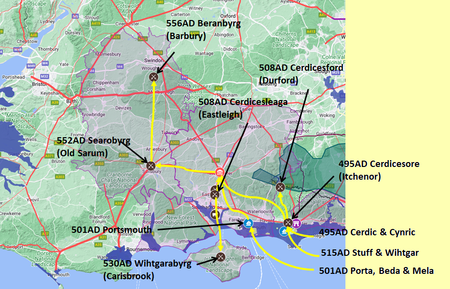
Map generated using Google My Maps 2024 - showing the Landscape, modern Counties and sea in 477AD
Please Note: this map is my interpretation of the Anglo Saxon Chronicles entries relating to Cerdic, Cynric and the West Saxons and their take over of Hampshire, the thin purple line shows the modern Hampshire boundary.
The logic for the coastal changes and the Forest of Andredsweald can be viewed on the following pages:
Roman Roads in Britain
Anglo Saxon Chronicles - 892AD - The Great Oak Forest of Andredsweald
The Variable Ocean: Was the high tide level in Saxon times at Pevensey at about 4.5 metres ?
The Variable Ocean: Was the high tide level in Saxon times in the Wash 4 to 5 metres higher ?
Landscape - The History of the Romney Marsh in maps
The Variable Ocean: Roman Locations that have not been identified and roads that just terminate
|
|
|
;)


