| Harald Hardrada's Invasion 1 — From Norway to the Yorkshire Coast, September 1066 |
|---|
| The man and his claim ▲ |
|---|
 Harald Sigurdsson, known to history as Hardrada — the Hard Ruler — was King of Norway from 1046 and one of the most formidable military commanders of the eleventh century. He had spent fifteen years as a mercenary and military commander in Kievan Rus and as captain of the Varangian Guard in Byzantine Constantinople before returning to Norway to seize the throne in 1046. His claim to the English throne rested on a disputed agreement between his predecessor Magnus the Good and the Danish king Harthacnut, who had briefly also ruled England, under which the survivor of the two was to inherit the other's kingdom. Magnus had never acted on this claim before his death in 1047. Hardrada inherited it and spent the following two decades looking for the right moment to press it. That moment arrived in January 1066 when Harold Godwinson seized the English throne on the death of Edward the Confessor, bypassing both Hardrada's claim and that of William of Normandy. Three claimants to one throne meant that 1066 would be settled by whoever moved fastest and struck hardest. Hardrada moved first.
| The coalition — Tostig Godwinson joins the Norse fleet ▲ |
|---|
|
The political dimension of Hardrada's invasion is as important as the military one. His alliance with Tostig Godwinson — the exiled brother of King Harold — transformed what might have been a straightforward Norse bid for the throne into a dynastic challenge with an English face. Tostig had been Earl of Northumbria until 1065, when a rebellion by his own people, backed by his brother Harold, stripped him of his earldom. He spent the winter of 1065–1066 in exile in Flanders, burning with resentment. He had already raided the English coast in the spring of 1066 with a small fleet assembled in Flanders, been driven off by the forces of the northern earls Edwin and Morcar, and retreated to Scotland where he spent the summer at the court of Malcolm III. There he received Hardrada's invitation to join the Norwegian fleet as co-commander, with the promise of his earldom restored if the invasion succeeded. Tostig accepted. The alliance gave Hardrada crucial intelligence about English northern defences, local political grievances in Northumbria that could be exploited, and the considerable propaganda value of a Godwinson fighting alongside a Norse king against his own brother. Tostig knew the landscape of Northumbria, its roads, its communities, and the political loyalties of its thegns better than any Norwegian ever could. He was, in effect, Hardrada's intelligence officer for the entire northern campaign.
| | |
|---|
The fleet assembles — Solund, late summer 1066 ▲ |
|---|
|
Hardrada assembled his invasion fleet at Solund in the Sognefjord on the western coast of Norway in late summer 1066. The saga sources give figures of around 300 longships for the core Norse fleet, to which Tostig's contingent and the forces of the Orkney jarls would be added, giving a combined force whose land army has been estimated at between 9,000 and 15,000 men. This was not a raiding party. It was a full-scale invasion force equipped for a sustained campaign and carrying the resources to hold territory after it was taken. Before leaving Norway, Hardrada had his son Magnus proclaimed king of Norway in his absence — a detail that tells us he understood this campaign was likely to end in either total victory or death, and he was arranging the succession accordingly.
The fleet's departure from Solund required a westerly passage to Shetland before turning south. The meteorological model proposed on the September Storm page of this site suggests this westward passage was made possible by a counter-clockwise low pressure system centred over the northern North Sea, whose southern flank produced the easterly winds needed for the Solund to Shetland leg, shifting to a northerly on its western flank as Hardrada turned south from Orkney toward England. The same Omega block pattern that was simultaneously trapping William's fleet at Dives with persistent contrary winds was, from its northern component, driving Hardrada south toward England at remarkable speed. [See: The September Storm — both fleets, one weather system]
| | |
|---|
Shetland and Orkney — building the coalition ▲ |
|---|
|
From Solund the fleet sailed west to Shetland, where it paused to take on water and provisions. It then moved south-west to Orkney, where Hardrada collected the Jarls Paul and Erlend Thorfinnsson — the Norse earls who administered Orkney as a Norwegian dependency — along with their men and ships. At Orkney, Hardrada also left behind his wife Elizaveta, daughter of Yaroslav the Wise of Kiev, and his daughters — a detail recorded in the Heimskringla that tells us he understood this campaign was likely to end in either total victory or death, and he did not want his family present for the latter. Tostig met the main fleet on the Scottish coast, probably at or near Dunfermline where John of Worcester places him at the court of Malcolm III, contributing additional ships and the detailed intelligence about English northern defences that would shape the campaign's opening moves. Malcolm III also contributed approximately 2,000 Scottish soldiers to the invasion force, giving the coalition an international character that reinforced its political ambition.
| | |
|---|
Tynemouth and the Tees — the fleet arrives ▲ |
|---|
|
The combined fleet made landfall at Tynemouth on 8 September 1066 — the same day Harold Godwinson stood down the English Channel fleet at the Isle of Wight because supplies were exhausted and the campaigning season appeared to be over. The coincidence of timing is striking: on the same day Harold lost his naval watch on the south coast, Hardrada's fleet appeared off the north-east coast of England. The Omega block that produced this simultaneity is discussed in detail on the September Storm page of this site. [See: The September Storm — both fleets, one weather system]
From Tynemouth the fleet moved south to the River Tees, where Hardrada and Tostig landed and entered Cleveland. The Heimskringla records that they began ravaging the coast immediately — Cleveland's farming and fishing communities, exposed on the coastal plain with no significant fortification, offered no meaningful resistance. The raiding here served the dual practical function of supplying the fleet with food and provisions while simultaneously announcing the invasion's arrival to the English interior. A mounted messenger from Cleveland could reach York — approximately 55 miles to the south-west — within a single day riding hard. The earls Edwin and Morcar, at York with the only English army available to resist the invasion, would have had news of the Norse fleet's presence on the Yorkshire coast within twenty-four hours of the Cleveland landing. The question of what they did with that warning is one the evidence addresses, albeit obliquely, in what happened next.
| | |
|---|
The name and status of Scarborough ▲ |
|---|
|
Before examining Hardrada's attack on Scarborough it is worth considering what the settlement actually was, because its name reveals something important about its function that the standard narrative overlooks. The name Scarborough is usually derived from the Old Norse Skardaburg — Scarthi's stronghold — taken from the thirteenth century Kormáks Saga account of a Viking called Thorgils Scarthi who supposedly established a fort there around AD 966 or 967. This etymology should be treated with considerable caution. The Kormáks Saga was compiled approximately two and a half centuries after the events it describes, and deriving a major settlement's name from a nickname recorded once in a late saga is methodologically weak. Medieval writers were prone to constructing personal-name etymologies backwards from place names that needed explaining, and Scarthi's stronghold has the character of exactly that kind of after-the-fact invention.
The more historically coherent reading begins with Old English. Scir in Saxon usage carries a primary meaning of office, charge, administration, or government — it is the same root that gives the English language the word shire, the fundamental unit of Saxon territorial governance. Burh is the standard Old English term for a fortified place with defined administrative and defensive functions. Scirburh — the administrative burh, the fortified seat of governmental authority — is a precise and functional name describing not what the settlement looked like but what it did. A secondary Saxon reading of scir as bright or shining — describing a prominent landmark visible from the sea — is also possible, but the administrative reading is the stronger one given what the headland was used for across many centuries.
The Roman signal station on Castle Hill at Scarborough was itself an administrative and communications installation, part of the late Roman coastal warning network of the Saxon Shore. Administrative use of the headland therefore has roots going back to the late third century. A scirburh in the Saxon system would be a natural node in the governance of the East Riding coastline — a place where dues were collected, obligations recorded, and royal authority exercised over the harbour and its fishing and trading communities below. The name itself may be a palimpsest of two successive administrative orders on the same headland: Saxon scir-governance beneath the Norse wapentake reorganisation of Yorkshire that followed the Danelaw settlement of the ninth century.
| | |
|---|
The burning of Scarborough ▲ |
|---|
|
Scarborough was the first community to resist Hardrada's demand for surrender as the fleet moved south from Cleveland. The Heimskringla records that the Norse fleet beached below the headland, Hardrada's men climbed Castle Hill, built a large bonfire on the summit, and pushed the burning material over the edge onto the town below. The tactic — using the headland's height to drop fire onto a settlement that could not defend itself from above — was militarily efficient and psychologically devastating. The burning of the scirburh, the administrative centre of the Yorkshire coast, sent a clear political message: the structures of Saxon authority could no longer protect the communities under their governance.
The effect was immediate. The Heimskringla records that other Northumbrian towns surrendered to Hardrada without resistance after Scarborough's burning. The action was not simply an act of destruction. It was a calculated demonstration designed to collapse English administrative authority along the entire coastal strip between the Tees and the Humber, preparing the ground for the main campaign to move inland. The communities that submitted did so because they had watched or heard of Scarborough burning and concluded that resistance was futile.
There is no archaeological evidence that has been securely identified with this burning. The headland has been extensively built over by the medieval castle begun by William le Gros around 1130, and any burning horizon from 1066 would be deeply buried if it survives at all. The Heimskringla account cannot be verified independently, but it is consistent with everything known about Norse raiding tactics and the strategic logic of the campaign. The caution appropriate to a thirteenth century saga source compiled two centuries after the events it describes applies throughout, but the broad outline — a major coastal settlement destroyed by fire as a demonstration of Norse power — is accepted by most scholars of the period.
| | |
|---|
Hellornes — a skirmish on the York road? ▲ |
|---|
|
After the burning of Scarborough the Heimskringla records a further engagement before the fleet reached the Humber. The Gutenberg translation reads: "Then the king proceeded south along the land, and brought up at Hellornes, where there came a force that had been assembled to oppose him, with which he had a battle, and gained the victory."
This single passage has received almost no attention in the standard accounts of the campaign, which jump directly from Scarborough to the Humber. Yet it records something significant: an English force had been specifically assembled to oppose Hardrada at a named location, implying both warning time and organised military response. The question of where Hellornes was has never been satisfactorily resolved, and the two main identifications — Holderness and Heslerton — point to very different kinds of engagement.
The standard identification in the scholarship that addresses it at all is Holderness — the peninsula between Scarborough and the Humber mouth. The directional language of the saga — "south along the land" — is superficially consistent with a coastal movement, and Holderness lies broadly south of Scarborough. But this identification has a serious geographical problem that the standard accounts do not address.
The place-name evidence for Holderness, analysed using the methodology developed on this site for interpreting Saxon æg island names, suggests that in early Saxon times Holderness was not a peninsula at all but an island landscape — a series of tidal islands separated from the Yorkshire mainland by elevated sea levels. [See the map above] The settlements of Hornsea, Withernsea, Kilnsea, and Skipsea all carry the -sea suffix, which on the interpretation developed on this site derives from Old English æg meaning an island rather than from a word for lake or pool as standard modern etymology suggests. The Domesday Book records Withernsea as Widfornessei — the -sei ending mapping directly onto æg and placing it firmly in the same island place-name family as the Pevensey æg settlements examined in detail elsewhere on this site. [See: Sea levels in the Anglo-Saxon period — the Pevensey evidence] Skipsea — the ship island, or island associated with ships — is particularly evocative in a military context, suggesting a landing place or anchorage rather than simply a settlement beside a mere. This interpretation of the Holderness place names as recording genuine tidal island status is the author's, based on the æg methodology applied consistently across the site, and is not the current position of mainstream place-name scholarship.
If this interpretation is correct, the consequences for the Hellornes identification are decisive. An English force assembled at York to oppose Hardrada could not have marched into Holderness — there was tidal water in the way. A blocking force does not choose a tidal island as its defensive position against an enemy with a fleet, because it commands nothing the Norse ships could not simply sail around. Equally a Norse land force proceeding south from Scarborough could not march into Holderness without crossing the tidal channels that separated the island landscape from the mainland. If the engagement at Hellornes was a land battle — and the Heimskringla passage describes it in terms consistent with a land engagement rather than a naval skirmish — it cannot have taken place in Holderness. The geography, read through the place-name evidence, rules it out.
The alternative identification — Heslerton, specifically West Heslerton on the southern margin of the Vale of Pickering approximately 12 miles south-west of Scarborough — fits the strategic logic of the campaign considerably better, despite receiving no attention in the standard literature. This identification is also the author's inference, not a position found in current scholarship on the campaign. The phonology is plausible: a Norse writer rendering an English place name phonetically two centuries after the events from oral sources could produce Hellornes from a name in the Heslerton family, though the correspondence is not exact and the identification cannot be proven on linguistic grounds alone. What makes it compelling is the road geography, the landscape hydrology, and the timing.
The Vale of Pickering in 1066 was itself a largely marshy landscape — a former glacial lake whose floor remained waterlogged and poorly drained. Roman roads research establishes that the eastern end of the Vale could realistically be crossed at only three points, and the principal road from Scarborough to York ran along the dry chalk ground of the Wolds escarpment on the southern margin of the Vale, avoiding the marshland to the north. West Heslerton sits precisely on this road, on the chalk Wolds, at the point where the southern escarpment route from Scarborough turns west towards York. It is not merely on a road to York — it is on the only practical road to York from Scarborough that avoided both the Vale marshes to the north and the Holderness tidal channels to the south and east. The manor of Pickering itself, which commanded this road from the north, was held by Earl Morcar before the Conquest — he had direct local knowledge of this landscape and its routes.
If Morcar at York received news of the Cleveland raiding within a day — entirely feasible for a mounted messenger covering 55 miles — and responded by sending a force south-east along the York road to block a potential Norse overland advance, West Heslerton is the natural blocking position: firm chalk ground commanding the road, with the Vale marshes protecting the northern flank. A thegnly household force rather than a full fyrd could muster at 12 miles' distance within hours of receiving the alarm. The engagement the saga records — a force assembled to oppose him, a battle, a Norse victory — is consistent with a scouting or foraging party from Scarborough encountering organised resistance on the York road and extracting itself. Victory in saga terms does not necessarily mean a decisive rout of the English. A Norse party that withdrew in good order after a harder-than-expected skirmish might be recorded as victorious by a writer sympathetic to Hardrada while still representing a check sufficient to redirect the campaign back to the river route.
That redirection is the strongest single argument for the Heslerton identification. If Hardrada had won a clear land engagement on the direct road to York with his main force, the logical next step is York. He did not take it. He returned to the fleet, sailed south to Ravenser, and approached York via the Humber and Ouse — a significantly longer journey that kept the army together with the fleet's logistical support. That is precisely what you would expect if a forward party had encountered serious organised resistance at the road's choke point and the main army concluded the overland route was contested.
To summarise the competing identifications: the Holderness reading has the saga's directional language superficially in its favour, but places a land battle in what the place-name evidence interpreted on this site suggests was a tidal island landscape inaccessible to a land force assembling from York — a position that commands no route worth blocking and that neither side could easily reach on foot. The Heslerton reading has the road geography, the blocking position, the muster timing, and the question of why Hardrada chose the river route in its favour, but requires a phonological identification that cannot be proven and is the author's inference unsupported by current scholarship. What the Heimskringla passage establishes beyond speculation is that an organised English force was assembled specifically to oppose Hardrada between Scarborough and the Humber, and that Hardrada chose the Humber river route to York rather than an overland march. Those facts stand regardless of where Hellornes was.
| 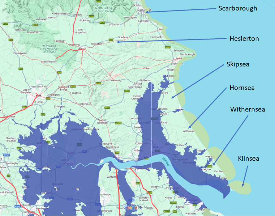
The map above is a representation of the York area if the high tide mark is raised to the 4.5 metre level as described by our Pevensey Islands page
Please Note the coastline is up to 5km further out in Roman times, and the Roman roads identified by Ivan D Margary in the area are shown in red. These were most likely still in use in 1066AD
Please Note:- the erosion rates for this area were provided by Urban Rim
| Ravenser and the approach to the Humber ▲ |
|---|
|
From Hellornes the fleet continued south to Ravenser — identified as Ravenspur at the mouth of the Humber, itself now lost to the same coastal erosion that has consumed the Holderness coastline — before turning west into the estuary. The Humber presented a different navigational challenge from the open North Sea passage. The wide estuary mouth with its shifting sandbanks, strong tidal currents, and complex channels demanded local knowledge the fleet had to coerce from local pilots or already possessed through prior intelligence about the Yorkshire coast. The fleet navigated successfully, turning north up the Ouse to Riccall, a landing point on the west bank approximately eight miles south of York, where Orderic Vitalis places the beaching on 20 September.
The speed of the overall passage — Tynemouth on 8 September to Riccall on 20 September, approximately 200 miles of coastal and estuarial navigation in twelve days with an unknown pause at Hellornes — is consistent with the persistent northerly following winds of the Omega block. The square sails of the Norse longships, designed precisely for running before a following wind, would have kept the fleet moving at four to six knots in the conditions the meteorological model describes. [See: The September Storm — both fleets, one weather system]
| | |
|---|
The strategic position on the eve of Fulford ▲ |
|---|
|
By approximately 19–20 September 1066, Hardrada's fleet was beached at Riccall and his army was on English soil in strength. The Yorkshire coast from the Tees to the Humber had been systematically worked over — Cleveland raided, Scarborough burned as a deliberate act of administrative decapitation, resistance encountered at Hellornes and the campaign redirected to the river route, the remaining coastal communities surrendering without further fight. The earls Edwin of Mercia and Morcar of Northumbria had known of the invasion since at least the Cleveland raiding twelve days earlier. They had received news of Scarborough's burning, of the towns that had submitted without resistance, and — if the Heslerton identification is correct — of a force sent south-east that had encountered the Norse advance on the York road and bought time but not stopped it. They had two choices: fall back and abandon York, or advance to meet the invasion before it reached the city walls. They chose to fight.
That decision, and the battle that followed at Fulford Gate on 20 September, is the subject of the next page in this series. What the coastal campaign established in the twelve days between Tynemouth and Riccall was the strategic context in which Edwin and Morcar made it: a Norse army of up to 15,000 men that had announced its power from Cleveland to Scarborough, demonstrated its reach as far as the York road, moved with extraordinary speed on following winds, and arrived at York's doorstep with every community between the Tees and the Humber either burned into submission or surrendered. The burning of Scarborough was not simply an act of violence. It was the opening move of a campaign designed to make English resistance in the north as psychologically difficult as it was militarily demanding. Fulford was the consequence. [See: The Battle of Fulford Gate]
| | |
|---|
A note on the sources ▲ |
|---|
|
The primary saga source for the entire campaign is the Heimskringla of Snorri Sturluson, compiled in Old Norse around 1225 — approximately 160 years after the events it describes. The Heimskringla draws on earlier skaldic poetry, oral tradition, and lost written sources, and its account of the English campaign is the most detailed single narrative available, but it is not a contemporary document and should be treated with appropriate caution throughout. John of Worcester's Chronicle, written closer to the events, provides corroborating dates and locations for the fleet's movements. The Anglo-Saxon Chronicles in manuscripts C, D, and E give the English perspective but with less geographical detail than the saga. For the specific locations of Cleveland, Scarborough, Hellornes, and Ravenser, the saga is the only source that names them, and all identifications of Hellornes carry the uncertainty appropriate to place names rendered phonetically in Old Norse by a writer who almost certainly never visited Yorkshire and was working from oral sources two centuries after the events. The geographical argument for Heslerton presented in this page is the author's inference from road geography, landscape hydrology, and strategic logic, and should be read as a reasoned possibility rather than an established identification.
| | |
|---|
References and sources ▲ |
|---|
|
Snorri Sturluson, Heimskringla — Saga of Harald Hardrade (compiled c.1225; Project Gutenberg EBook #598)
John of Worcester, Chronicle — Tynemouth 8 September; fleet movements
Orderic Vitalis, Historia Ecclesiastica — Riccall beaching point and army movements
Anglo-Saxon Chronicle, manuscripts C, D and E
DeVries, K. The Norwegian Invasion of England in 1066 (Boydell Press, 1999)
Roads of Roman Britain — RR816 Norton to Filey; RR817 Sherburn/Staxton to Scarborough
de Boer, G. — estimate of Holderness coastal erosion since 1066
Powlesland, D. et al. West Heslerton Assessment, Internet Archaeology 5 (1998) — note: settlement abandonment dated to c.850 AD, not relevant to the 1066 campaign
saxonhistory.co.uk — The September Storm [See: September Storm page]
|
|
|
;)
)
)


