| Anglo Saxon Chronicles - 485AD - Mearcrædesburnan stæðe
(Ælle,Cymen, Wlenca and Cissa ) |
|---|
| The entry from the Chronicles |
|---|
Original text
Her Ælle gefeaht wiþ Walas neah Mearcrædesburnan stæðe.
Translation
485AD. This year Ælle defeated the Welsh near Mearcrædesburnan stæðe.
| Where might it be |
|---|
|
Mearcrædesburnan stæðe breaks into three elements: a stream
(burnan), a landing point at that stream (stæðe —
a staith), and a qualifying prefix that has two plausible readings.
The first reading takes the prefix as mearc, the Saxon word for
boundary or border — the same root that gives us the Marches and the place-name element
"mark". This would make the full name the landing point on the boundary stream,
which fits a battle location well. Boundaries were natural lines of resistance, and a
defended stream crossing on the edge of British-held territory is exactly where you would
expect a pitched engagement.
The second reading takes the prefix as cræðes, pronounced "creth",
a possible phonetic variant of cærse or cresse, meaning
watercress. This would give the landing point on the watercress stream. Watercress
grows only in clean, fast-moving chalk streams, which in this part of England means
Hampshire or West Sussex — usefully narrowing the geography.
The two readings are not in competition. At Binsted the War Dyke runs north to south
across the old Roman coast road — it is a boundary earthwork, built to mark and
defend the western edge of British-held Sussex against exactly this kind of westward Saxon
advance. The stream at Binsted is a chalk stream. So whichever reading is correct — boundary
stream or watercress stream — both point independently to the same place.
| | |
|---|
Possible interpretation of the Chronicles |
|---|
Mearcrædesburnan stæðe is most likely at Binsted, where there is an ancient earthworks that probably was designed to defend Chichester, once these troop had been defeated then Chichester would have been open to the Saxons, and they would easily have taken the city.
It would seem likely that Ælle taking Chichester would have been an important story for the old Chroniclers, however no evidence of this has been found, hence a battle at Binsted which could have been the outer boundary of Chichester would have been important enough to be recorded.
This area was the ancestral home of the Regnensis who had their capital at Chichester(Noviomagus Reginorum) so once this was taken by Aelle, he had control of the area.
A great deal of conjecture by historians has said that a possible location for this battle was at Town Creep near modern Battle, but this area would have been occupied by the Haestingas and as they appear to be Saxon and friendly with the Suth Saxons this would seem very unlikely.
Another factor that makes this less likely is that this battle took place 5 years before Anderida was taken, and as Battle is further East of Anderida and only about 10 miles away, you would have expected the Saxons to have taken Anderida before Mearcrædesburnan stæðe, if it were located here.
| Conclusion |
|---|
|
The battle at Mearcrædesburnan stæðe in 485AD was not an isolated skirmish. Read
alongside the other Chronicles entries for Ælle, it appears to be the western stroke of
a deliberate campaign to define and secure the kingdom of the South Saxons. Having
established his bridgehead on the Adur in 477AD, Ælle pushed west along the Roman coast
road, broke through the War Dyke at Binsted, and took Chichester — the old Roman capital
of the Regnenses and the natural western limit of Sussex. With Chichester secured, his
western boundary was fixed.
Six years later in 491AD he moved in the opposite direction, taking Anderida at
Pevensey and securing his eastern flank. The Andredsweald formed a natural barrier to
the north. The kingdom was complete: Chichester to Pevensey, forest to the north, sea
to the south.
East Sussex he appears to have left alone. The Haestingas already held it, they were
Saxon, and the Chronicles record no conflict between them and Ælle. His campaign was not
conquest of the whole peninsula but consolidation of what would become West Sussex — with
the War Dyke at Binsted marking the last point of British resistance before that
consolidation was complete.
| | |
|---|
Map showing the Battles of Aelle, Cymen, Wlencing & Cissa |
|---|
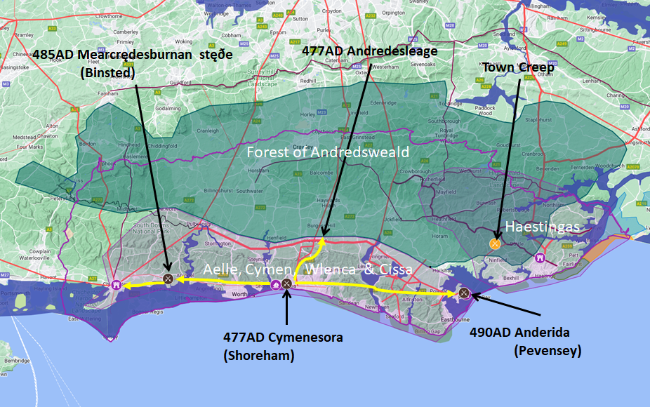
Map generated using Google My Maps 2024 - showing the Landscape, modern Counties and sea in 477AD
Please Note: this map is my interpretation of the Anglo Saxon Chronicles entries relating to Aelle, Cymen, Wlencing & Cissa and their take over of Sussex, the thin purple line shows the modern Sussex boundary.
Aelle controlled West Sussex up to Andredsweald, and the Haestingas controlled East Sussex both of these areas are shaded in light purple.
The logic for the coastal changes and the Forest of Andredsweald can be viewed on the following pages:
Roman Roads in Britain
The Great Forest of Andredsweald - Anglo Saxon Chronicles
Landscape - Was the sea level in Saxon times at Pevensey 4 to 5 metres higher ?
Was the high tide in Saxon times 5 metres higher ? - the Wash
Landscape - The History of the Romney Marsh in maps
Roman Locations that have not been identified and roads that just terminate
|
|
;)