| Battle of Hastings 1066AD - X - The Retreat, another Malfosse ? |
|---|
|
| Introduction ▲ |
|---|
The Battle of Hastings ended on 14 October 1066. Harold was dead, his army broken. But the battle did not simply stop — it dissolved into pursuit, rout and darkness. And somewhere in the landscape north of the battlefield, something happened that the chroniclers remembered for generations.
Multiple independent sources record that pursuing Norman cavalry fell without warning into an ancient trench, overgrown and concealed. Horses and armoured men rolled over each other and were crushed. The routed Saxons briefly rallied. Then the pursuit continued.
This page approaches that incident as a forensic problem. The chronicles provide witness testimony. The landscape provides physical evidence. The question is whether the two can be made to agree — and if so, where.
The methodology is straightforward. First, establish what the sources actually say and whether they are describing the same event or different ones. Second, define the geographical constraints: what kind of feature could cause this, and where in the landscape could it plausibly have been? Third, survey the available evidence — Roman ironworks, ancient earthworks, LIDAR data — against those constraints. Finally, present what the evidence shows and where it points.
What follows is not a conclusion dressed as an argument. It is an argument that leads, carefully, to a conclusion.
| The Retreat Malfosse - Did it exist and what was it ? ▲ |
|---|
The term the Malfosse was added to the details of the Battle of Hastings from the Chronicles of Battle Abbey.
This originated from the following:
Quod quidem baratrum sortito ex accidenti uocabulo Malfosse hodieque nuncupatu
Which translates roughly to:
This ditch has been named for the accident, and today it is called Malfosse.
From the documentation it would seem that there could have been two malfosse's or malfossei, one during the battle and a second while chasing the retreating Saxons.
A military defininition of Fossé (Fr.) is an exterior ditch fronting a rampart or curtain.
| Documentary evidence ▲ |
|---|
The following shows 'all references' in the Chronicles to a Malfosse, the ones with red comments can be interpreted as during the Saxon retreat.
William of Jumièges
However confidence returned to the fugitives when they found a good chance to renew the battle, thanks to a broken rampart and labyrinth of ditches.
Recorded as the Saxons flee
Orderic Vitalis
(The Normans, finding the English completely routed, pursued them vigorously all Sunday night, but not without suffering a great loss ; for, galloping onward in hot pursuit, they fell unawares, horses and armour, into an ancient trench, overgrown and concealed by rank grass, and men in their armour and horses rolling over each other, were crushed and smothered. This accident restored confidence to the routed English, for, perceiving the advantage given them by the mouldering rampart and a succession of ditches, they rallied in a body, and, making a sudden stand, caused the Normans severe loss.)
This again records that the malfosse was after the battle
The second part of this account could apply to the battle and not the rout as routing soldiers do not usually reform as their units are broken up and spread out by the rout.
Master Wace
(and they had moreover made a fosse, which went across the field),
this is a possibility if the Normans broke through the Shield Wall and hence into the Saxon lines, but were then pushed back into the ditch(fosse) great losses would have occurred.
Before the battle Master Wace also describes Saxon defences
(There he said he would defend himself against whoever should seek him ; and he had the place well examined, and surrounded it by a good fosse, leaving an entrance on each of three sides, which were ordered to be all well guarded.)
In his section on THE ROLL OF THE NORMAN LORDS
(And now might be heard the loud clang and cry of battle, and the clashing of lances. The English stood firm in their barricades, and shivered the lances, beating them into pieces with their bills and maces. The Normans drew their swords and hewed down the barricades, and the English in great trouble fell back upon their standard, where were collected the maimed and wounded.)
claiming that this was a Saxon made defence this potentially explains the battle ditch description.
Henry of Huntingdon
(But Harold had formed his whole army in close column, making a rampart that the Normans could not penetrate. Duke William therefore commanded his troops to make a feigned retreat. In their flight they they happened unawares of a deep trench which was treacherously covered into which numbers fell and perished. While the English were engaged in pursuit, the main body of the Normans broke the centre of the enemy's line, which being perceived by those in pursuit over the concealed trench, when they were consequently recalled most of them fell there.)
This sounds like the Normans attacked a defensive ditch, broke over the rampart then into the Saxon line, then were pushed back into the ditch and finally routed, the English then followed up but they were also cut down by the cavalry while pursuing the routed Norman men-at-arms.
Florence of Worcester
(before a third of his army was in fighting order. He gave them battle at a place nine miles from Hastings, where they had built a fort. The English being crowded in a confined position)
from this account it would seem that Harold had built a fort as the English were in a confined position, which could be a ditch on three sides as described by Master Wace(above).
The Chronicles of Battle Abbey
(here lay between the hostile armies a certain dreadful precipice, caused either by a natural chasm of the earth, or by some convulsion of the elements. It was of considerable extent, and being overgrown with bushes or brambles was not very easily seen, and great numbers of men — principally Normans in pursuit of the English — were suffocated in it).
This appears to record that the Malfosse was in the Battlefield, however it could be read as after the battle.
The Bayeux Tapestry has a scene where horses are seen vertically and a very rough piece of ground goes up to the Saxon positions, this could also be interpreted as a ditch in front of the Saxon lines with men and horses falling into it. A further interesting part of this image is that the legs of the Saxons at the top of the hill are behind the hilltop which could be interpreted as defensive shieldwall above the fosse.
| Local features that could be an ancient trench ▲ |
|---|
So if the malfosse is during the retreat, then it has to be near one of the roads out of the area and not in the forest. This is because it wouldn't have been hidden and also would have blocked the road and been obvious to both the retreating Saxons and the chasing Norman Cavalry.
We are now looking for landscape features that are on either the old ridgeways or the Roman roads and probably not in the Forest, please see the map of the area below that shows Andredsweald and the Roman roads and ridgeways.
| Overall map of the Area ▲ |
|---|
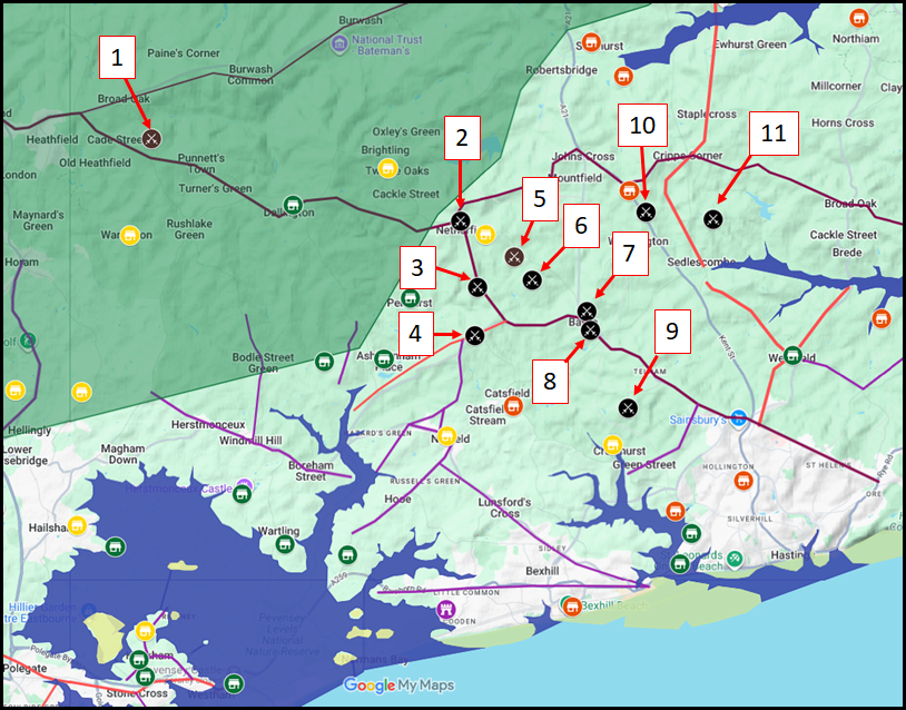
The Green shaded area shows the approximate location of the Great Forest of Andredweald, the red lines are the Roman roads as described by Ivan D Margary, the maroon lines are the ancient ridgeways again as described by Ivan Margary.
The Purple lines are roads that we have added as they are described with the 'Street' snippet implying these were the smaller Roman roads in the area.
The blue areas show the valleys with the high tide mark at 4.5 metres hence were sea inlets making them impassible to Infantry and Cavalry.
| Possible Saxon retreat Routes ▲ |
|---|
The Green shaded area shows the approximate location of the Great Forest of Andredweald, the red lines are the Roman roads as described by Ivan D Margary, the maroon lines are the ancient ridgeways again as described by Ivan Margary.
The Purple lines are roads that we have added as they are described with the 'Street' snippet implying these were the smaller Roman roads in the area.
The blue areas show the valleys with the high tide mark at 4.5 metres hence were sea inlets making them impassible to Infantry and Cavalry.
| What route would a retreat take from each Battle Site ▲ |
|---|
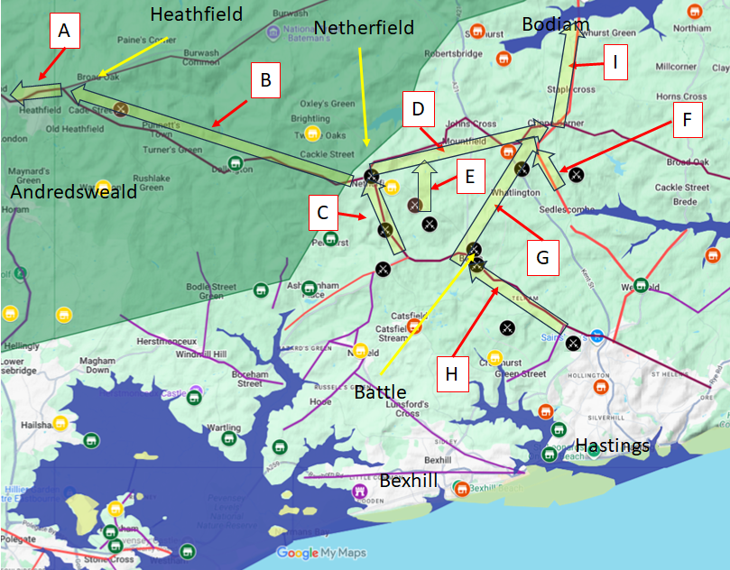
The Hoar Apple Tree
-
The most logical escape route from this location would be via route the ridgeway from Heathfield to Crowborough(A) joining the Margary M14 road at Crowborough for a march to London.
- Netherfield
-
There are two escape routes from here, the first being the ridgeway through the Forest via the Netherfield to Heathfield Ridgeway(B) and then via the ridgeway from Heathfield to Crowborough(A) joining the Margary M14 road at Crowborough for a march to London.
The second would be along the Netherfield to Rye Ridgeway(D) to Cripps Corner then down the Margary M13 to Bodiam(I).
- Creep Wood
-
This escape route starts on the Battle to Netherfield Ridgeway(C) up Kame Hythe road to Netherfield, then there are the two routes out of the area as per the Netherfield entry above.
- Normanhurst
-
This escape route starts on the Battle to Netherfield Ridgeway(C) up Kame Hythe road to Netherfield, then there are the two routes out of the area as per the Netherfield entry above.
- Ashes Wood
-
This escape route would need to go from Ashes Wood north across country(E) to get to the Netherfield to Rye Ridgeway(D) to Cripps Corner then down the Margary M13 to Bodiam(I)
- Beech Farm Hill
-
This escape route would need to go from Beech Farm Hill north across country(E) as for the Ashes Wood location (as they are only a few hundred yards apart) to get to the Netherfield to Rye Ridgeway(D) to Cripps Corner then down the Margary M13 to Bodiam(I).
- Caldbec Hill
-
This escape route would have to be across country and the top of the Brede valley to get to the original Whatlington which was near the Vinehall School area(G) where it would join the Netherfield to Rye Ridgeway(D) to Cripps Corner then down the Margary M13 to Bodiam(I).
- Battle Abbey
-
This escape route would have to be across country and the top of the Brede valley to get to the original Whatlington which was near the Vinehall School area(G) where it would join the Netherfield to Rye Ridgeway(D) to Cripps Corner then down the Margary M13 to Bodiam(I).
- Crowhurst
-
This escape route would have to be from the battle site down the Hastings to Battle ridgeway(H) then across country and the top of the Brede valley to get to the original Whatlington which was near the Vinehall School area(G) where it would join the Netherfield to Rye Ridgeway(D) to Cripps Corner then down the Margary M13 to Bodiam(I).
- Whatlington
-
This escape route is from the original Whatlington which was near the Vinehall School area where it joined the Netherfield to Rye Ridgeway(D) to Cripps Corner then down the Margary M13 to Bodiam(I)
- Sedlescombe
-
This escape route would be down Margary M13 (F) to continue down the Margary M13 to Bodiam(I).
- Blackhorse Hill
-
This escape route would have to be from the battle site down the Hastings to Battle ridgeway(H) then across country and the top of the Brede valley to get to the original Whatlington which was near the Vinehall School area(G) where it would join the Netherfield to Rye Ridgeway(D) to Cripps Corner then down the Margary M13 to Bodiam(I).
| What could this Ancient Trench be ▲ |
|---|
In this area, the Romans had some of the largest iron workings in the Empire, such as Beauport Park, Oaklands, Bardown and Footlands, so are any of these near or on the routes described above.
So if we interrogate the Wealden Iron Research pages for iron works in the Battle and Sedlescombe areas that were in use in the Iron Age,Roman and Saxon times, we only get the following 5 sites.
- Beauport Park - this is near to Blackhorse Hill and not on any of the routes
- Footlands - this is on the Margary M13 route, but could only be valid on route G.
- Pepperingeye this is to the south of the town of Battle, so the Saxons would be retreating towards the Norman Camp, so completely the wrong direction.
- Petley Wood - this is in the Brede valley, but due North of Battle so possibly route G.
- Thorp's Wood - this is to the South East of Cripps Corner, so only possible if retreating down F.
This implies that it was unlikely to be a Roman Ironworks, unless retreating down route G.
Are there any other features this could be, so lets look for old Earthworks in the area.
After looking at the area using Streetmap.co.uk there is only one earthwork on any of the routes:
This is found in Castle Wood at Mountfield, which is directly on route D.
Then if we look at the Lidar on following National Library of Scotland map.
We can see the earthworks and an excavated section, which was an iron works, but its period has not been identified again near Castle Wood at Mountfield.
The location in Castle Wood at Mountfield — and as noted on our Roman Fortification Types page, place names starting with 'Castle' seem to derive from the Roman Castellum. The name itself may therefore be preserving a memory of a Roman fortified position on this ridgeway. The LIDAR evidence suggests a feature of 1-2 hectares, which at the larger estimate would be consistent with a burgus rather than a simple watchtower castellum — though the interpretation remains uncertain without ground survey.
There are other what look like quarries along route D near to Cripps Corner but we have no dates for these, or even what they were.
| Conclusion ▲ |
|---|
The documentary evidence establishes that the retreat Malfosse, if it existed, must satisfy two conditions: it must be a substantial pre-existing obstacle, ancient enough to be overgrown and concealed by 1066, and it must lie on or immediately adjacent to one of the ridgeways or Roman roads out of the battlefield area — since retreating infantry and pursuing cavalry would not have moved through dense forest.
Of the known Roman ironworks in the area, most lie well off any plausible retreat route. Footlands sits on Margary's M13 but only falls on route G; the remaining sites at Beauport Park, Pepperingeye, Petley Wood and Thorp's Wood do not intersect any of the routes described above. A Roman ironworks origin for the retreat Malfosse therefore seems unlikely unless the retreat followed route G.
Survey of the area has identified only one earthwork on any of the retreat routes — the Castle Wood earthworks at Mountfield, directly on route D. The location is significant in itself: as noted on our Roman Fortification Types page, place names starting with 'Castle' derive from the Roman Castellum, suggesting the name may preserve a memory of a Roman military presence on this ridgeway. LIDAR analysis indicates a feature of between 1 and 2 hectares, still retaining approximately one metre of depth after nearly a thousand years of silting and weathering — indicating the feature was considerably more substantial in 1066. Adjacent to this, LIDAR also reveals an undated excavated section that may be an associated ironworks, and further undated features near Cripps Corner on the same alignment.
The surviving depth alone is significant. A feature that retains a metre of relief after this length of time was either originally very deep, very wide, or both — consistent with Orderic Vitalis's description of horses and armoured men rolling over each other and being crushed, and with the Chronicles of Battle Abbey's description of a precipice of considerable extent. A simple field boundary or minor drainage ditch would not survive in this condition.
Whether the Castle Wood earthworks are a Roman castellum or burgus controlling the ridgeway, an industrial enclosure, or some other pre-Conquest feature cannot be determined without ground investigation. What the landscape evidence does establish is that this is currently the only identifiable candidate on any retreat route that satisfies all the basic requirements — pre-existing, substantial, concealed by overgrowth, and directly on a road that retreating Saxons and pursuing Norman cavalry would have used. The location of the retreat Malfosse remains open, but the landscape evidence points clearly to route D and to Castle Wood as the place to look.
|
|
|
|
;)
)
)


