|
Anglo Saxon Chronicles - 914AD - Alfred the Great and the Burghal Hideage |
|---|
| |
|---|
Index |
|---|
|
Source ▲ |
|---|
From Wikipedia
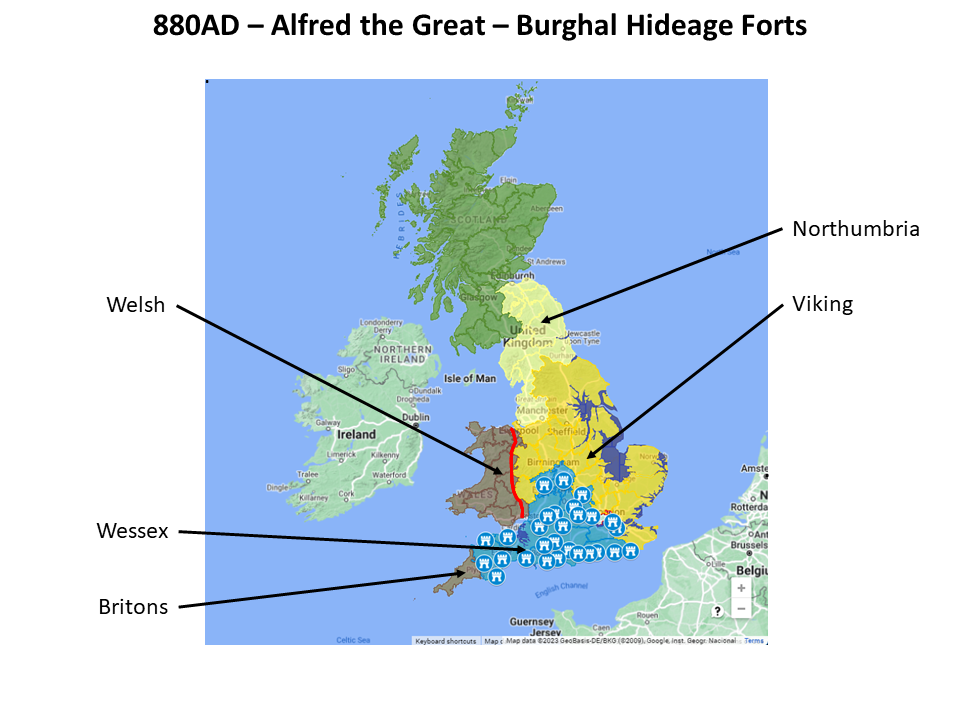
After his victory over the Danes at the Battle of Edington (878AD) and the departure of another Viking army from Fulham in 880AD, Alfred the Great set about building a system of fortified towns or forts, known as burhs, in response to the Viking threat. These burhs included former Roman towns (where stone walls were repaired and perimeter ditches sometimes added), temporary forts and substantial new towns.
The Burgal Hidage is a collection of a number of medieval texts that describe the location of defensive forts around the state of Wessex during the time of Alfred the Great. The document was named the Burghal Hidage by F. W. Maitland in 1897 after a great deal of research into the subject.
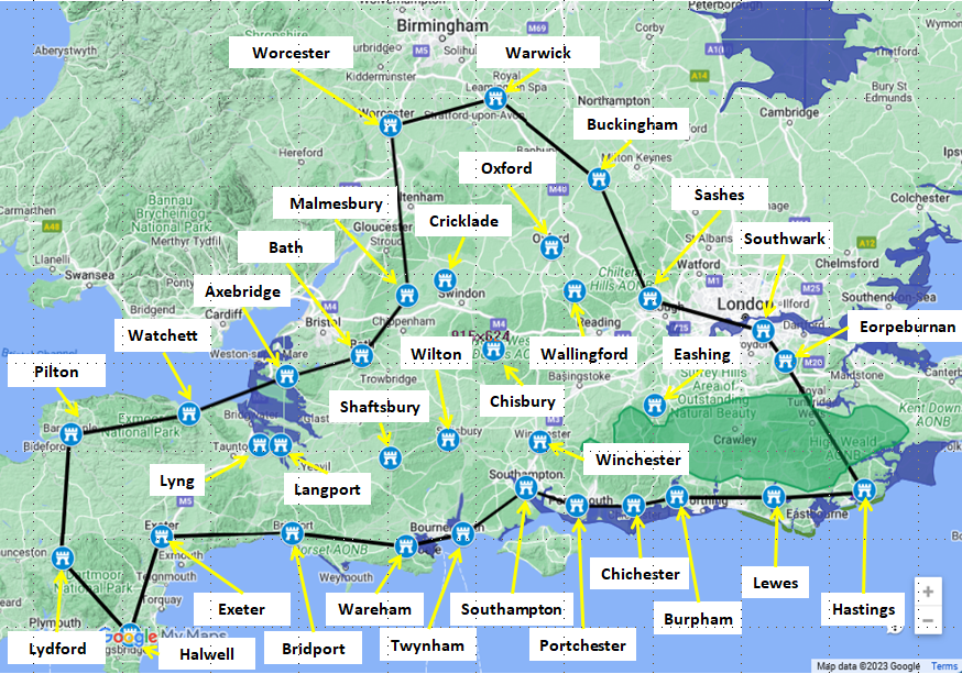
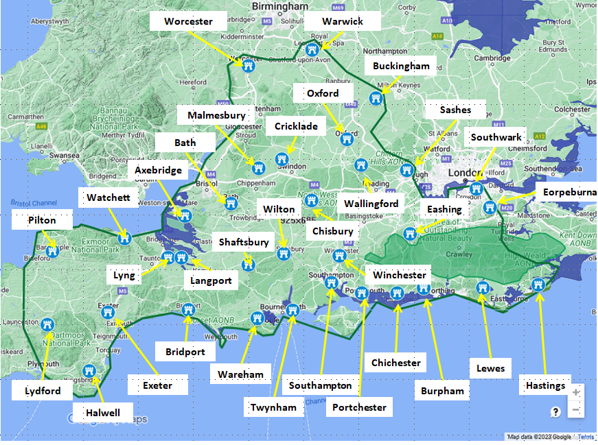
The documents list the major defensive forts anti clockwise around Wessex starting at the unproven location of 'Eorpeburnan' somewhere on the Kent,Sussex or Surrey borders and ending at the last fort in the list at Southwark on the Thames .
The Anglo Saxon word Burgh or more correctly Burh describes a defensive position or fort usually on a hill with a defensive ditch and bank topped with wooden walls and an internal regular layout to help the defenders. These Burhs were mostly built during the reign of Alfred the Great to defend Wessex against the Viking invaders.
Each Burh has a number of hides associated with it, which describes the size of the Burh and its defensive population.
|
Size of the Forts ▲ |
|---|
The original starting text reads
To anes æcere bræde on Ɵealstillinge 7 þære Ɵære gebirirgeað. xvi hida Gif ælc hid byþ be anum men gemannod þonne mæg man gesettan ælce gyrde mid feoƟer mannun. þonne gebyreð to
tƟentigan gyrdan on Ɵealstillinge. hundeahtatig hida.
This translates to
For one acre breadth of wall-setting & manning is required 16 hides, if each hide is one man, then the manpower to be set for each pole is with four men. Then is required for twenty poles of wall-
setting eighty hides.
with the finishing text reading
Gif se ymbegang mara biþ. þonne mæg man eaþe þone ofereacan geþencan of þisse tale for þon ealning to anum furlange gebyreð sixtig manna. 7. c. þonne biþ ælc gyrd mid feoƟer mannum geset
This translates to
If the surrounding is greater, then the manpower can easily be reckoned from this assessing, since there is always required for one furlong breadth sixty men & 100; then each pole is set with four
men.
This means that from the first statement:
An acres width of wall(aprox 208ft) needs 16 hides to build - this equates to about 13ft per hide, but this appears to be the construction dimensions.
A pole of wall(16.5 ft) requires 4 defenders and 20 poles requires 80 men, and 1 defender is required for each 4ft of wall which is provided by 1 hide.
Therefore a hide defends 4ft of wall
From the table shown above the Hastings Burh of 500 hides would have a wall of 125 poles so about 2000ft(aprox 610mtrs) of wall which would enclose a 500ft square of land(2.3 hectares) which would have needed a garrison of 500 men to defend, and provide a refuge to an additional 3,938 people.
Please Note
The figures for the refugees below are calculated using the following assumptions
- For simplicity of calculation, assume the burh was roughly square. This gives the length of one side as Perimeter / 4.
- That each person requires about 4 square metres of space for themselves and their belongings to account for small livestock (like chickens, goats, or a few sheep), personal belongings, and essential movement within the packed crowd.
- The available space is only 70% to allow for essential infrastructure that made the refuge functional: the main streets for moving defenders, the central garrison area, water sources, storage pits for grain, and likely a designated livestock pen for larger animals that couldn't be kept with families.
|
|
|
Wall length |
Area |
Population |
|
hides |
ft |
mtrs |
sq mtr |
hectares |
garrison |
refugees |
| Eorpeburnan |
324 |
1296 |
395 |
9753 |
0.98 |
324 |
1,651 |
| Hastings |
500 |
2000 |
610 |
23226 |
2.32 |
500 |
3,938 |
| Lewes |
1300 |
5200 |
1585 |
157006 |
15.70 |
1300 |
26,618 |
| Burpham |
720 |
2880 |
878 |
48161 |
4.82 |
720 |
8,165 |
| Chichester |
1500 |
6000 |
1829 |
209032 |
20.90 |
1500 |
35,438 |
| Portchester |
500 |
2000 |
610 |
23226 |
2.32 |
500 |
3,938 |
| Southampton |
150 |
600 |
183 |
2090 |
0.21 |
150 |
354 |
| Winchester |
2400 |
9600 |
2926 |
535122 |
53.51 |
2400 |
90,720 |
| Wilton |
2400 |
9600 |
2926 |
535122 |
53.51 |
2400 |
90,720 |
| Chisbury |
700 |
2800 |
853 |
45522 |
4.55 |
700 |
7,718 |
| Shaftesbury |
700 |
2800 |
853 |
45522 |
4.55 |
700 |
7,718 |
| Twynam (Christchurch) |
470 |
1880 |
573 |
20522 |
2.05 |
470 |
3,479 |
| Wareham |
1600 |
6400 |
1951 |
237832 |
23.78 |
1600 |
40,320 |
| Bridport |
760 |
3040 |
927 |
53661 |
5.37 |
760 |
9,097 |
| Exeter |
734 |
2936 |
895 |
50052 |
5.01 |
734 |
3,424 |
| Halwell |
300 |
1200 |
366 |
8361 |
0.84 |
300 |
1,418 |
| Lydford |
140 |
560 |
171 |
1821 |
0.18 |
140 |
309 |
| Pilton |
360 |
1440 |
439 |
12040 |
1.20 |
360 |
2,041 |
| Watchet |
513 |
2052 |
625 |
24449 |
2.44 |
513 |
4,135 |
| Axbridge |
400 |
1600 |
488 |
14864 |
1.49 |
400 |
2,520 |
| Lyng |
100 |
400 |
122 |
929 |
0.09 |
100 |
158 |
| Langport |
600 |
2400 |
732 |
33445 |
3.34 |
600 |
5,670 |
| Bath |
1000 |
4000 |
1219 |
92903 |
9.29 |
1000 |
15,750 |
| Malmesbury |
1200 |
4800 |
1463 |
133780 |
13.38 |
1200 |
22,680 |
| Cricklade |
1500 |
6000 |
1829 |
209032 |
20.90 |
1500 |
35,438 |
| Oxford |
1400 |
5600 |
1707 |
182090 |
18.21 |
1400 |
35,438 |
| Wallingford |
2400 |
9600 |
2926 |
535122 |
53.51 |
2400 |
90,720 |
| Buckingham |
1600 |
6400 |
1951 |
237832 |
23.78 |
1600 |
40,320 |
| Sashes |
1000 |
4000 |
1219 |
92903 |
9.29 |
1000 |
15,750 |
| Eashing |
600 |
2400 |
732 |
33445 |
3.34 |
600 |
6,237 |
| Southwark |
1800 |
7200 |
2195 |
301006 |
30.10 |
1800 |
51,030 |
| Worcester |
1200 |
4800 |
1463 |
133780 |
13.38 |
1200 |
22,680 |
| Warwick |
2400 |
9600 |
2926 |
535122 |
53.51 |
2400 |
90,720 |
|
Likely Locations of the Burh's ▲ |
|---|
The images below are made up from, to the left, based on Google My Maps overlayed with the fort area, those to the right are from the National Library of Scotland with the 'OS Six inch map 1888-1915' overlayed with a 'Lidar DSM 1M' lidar image.
|
| |
|---|
Eorpeburnan -324 hides ▲ |
|---|
Eorpburnan originally spelt in the hideage as eorþ burnan translates to the earthy stream
My suggestion of a likely location is modern Orpington which translates from eorþ ing tun translating as the earth fort on the hill.
This is based on the etymology of the name, and also its location between the Forest of Andredsweald and the Burh at Southwark which would make it a strategic position to block passage between Andredsweald and the Thames. This area was probably more heavily populated than areas of South Kent as suggested by academics for Newenden.
There is no hard evidence for the location of the Burh, but two other sites have been proposed, based on an interpretation of the Anglo Saxon Chronicles record from 892AD when the Vikings destroyed an unfinished fort close to Appledore.
Castle Toll at Newington on the Eastern Rother in South Kent.
'Castle Toll is a small motte and bailey on a promontory into the Eastern river Rother.'
My thoughts are that this is an unlikely location for the following reasons:
- It is right on the edge of Andredsweald and is also only 10 miles from the Hastings Burh which would have been in the old Kingdom of Hastings.
- The size of the motte and bailey would seem to be too small for the Burh.
- This fort was recorded as destroyed so it would have to be a fast rebuild to have it ready for the Hideage.
- he Vikings destroyed the fort and then setup camp in Appledore, this implies the fort was nearer the coast, and Newenden is further inland.
|
Hastings ▲ |
|---|
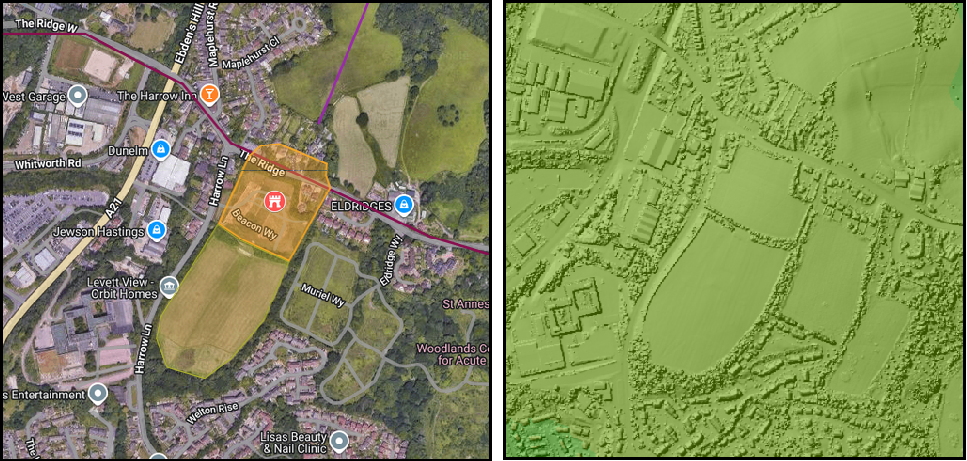
Hastings - 500 hides
The fort was probably at Baldslow down which derives from baels hleow dun meaning the fire refuge on the hill
The shaded area in orange is 628 metres around which is close to the calculated 610 metres. This fort could have held about 3,938 refugees and 500 soldiers.
This area is on a hill with good views all round and steep sides, and is on the old Ridgeway from Fairlight to Crowborough.
|
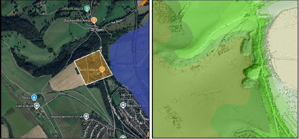
Lewes - 1300 hides
The fort was probably on Offham down, the name derives from Lewes hleow eas meaning the refuge on the river
The shaded area in orange is 1370 metres around which is close to the calculated 1585 metres. This fort could have held about 26,618 refugees and 1300 soldiers.
This area is on a high hill overlooking the river, but has lost some of its area due to chalk mining.
|
Burpham ▲ |
|---|
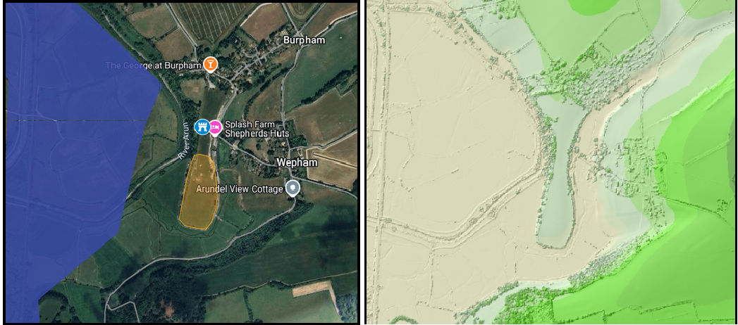 Burpham - 720 hides
Burpham from burþ ham which translates to the fortress settlement in the valley
The shaded area in orange is 881 metres around which is close to the calculated 878 metres. This fort could have held about 8,165 refugees and 720 soldiers.
This area was on a promontary into the river Arun which would mean that only one side was on the land, the river has eroded a lot of the original land outside the fort.
|
Chichester - 1500 hides ▲ |
|---|
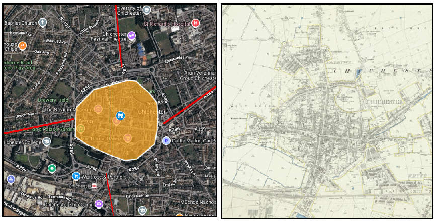
| Chichester derives from chyee ceaster which translates to the roman fortress of the Crows |
| The area covered by the image is the boundary of the old Roman fortress which has a boundary of 2140m and an area of 34.4 hectares. |
|
| |
|---|
Portchester - 500 hides ▲ |
|---|
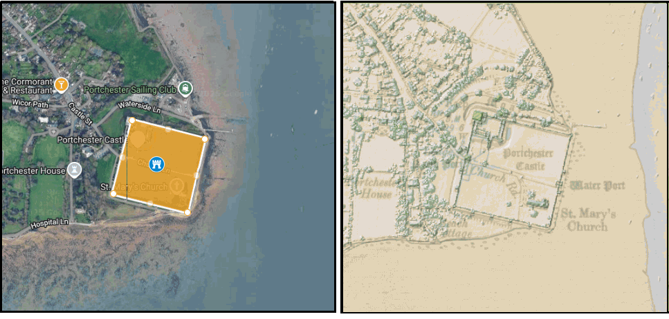
| Portchester derives from port ceaster which translates to the roman fortress with the harbour. The area covered by the image has a boundary of 740m and an area of 3.42 hectares. |
|
| |
|---|
Southampton - 150 hides ▲ |
|---|
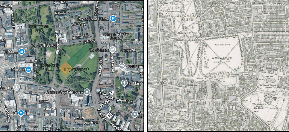
| Southampton derives from suþ þam tun which translates to the southern wet place on the hill |
| Please Note: It is difficult to identify a site in Southampton due to the sheer number of buildings that have been erected since 914AD. However I have noticed that the Burhs are sometimes on playing fields, and this one is called Hoglands that may have been derived from 'Hleow land' meaning the land where the burh is, so that is my Guess. There seem to be ground marks on the Google maps where the orange patch is located..
The area covered by the orange image has a boundary of 198m and an area of 0.24 hectares. |
|
| |
|---|
Winchester - 2400 hides ▲ |
|---|
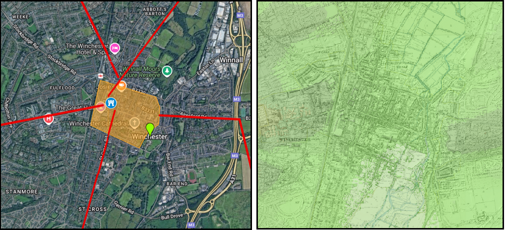
| Winchester derives from win ceaster which translates to the roman fortress of the wine |
| The area covered by the image is the boundary of the old Roman fortress which has a boundary of 3000m and an area of 58.6 hectares. |
|
| |
|---|
Wilton - 1400 hides ▲ |
|---|
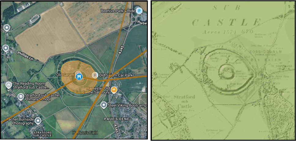
| The most likely location for this fort was at Old Sarum the old Roman fort on the junction of two major Roman roads. The area covered by the image has a boundary of 1.4km and an area of 15.0 hectares |
|
| |
|---|
Chisbury - 700 hides ▲ |
|---|
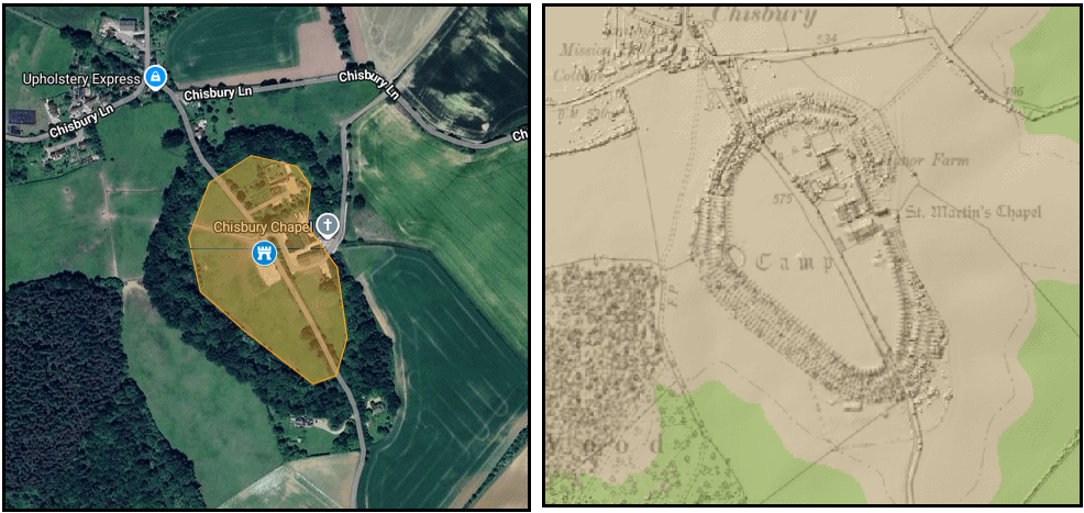
| Chisbury derived from 'cise byrg' - the cheese fort |
|---|
| The most likely location for this fort was at Chisbury Camp an old Iron Age fort.The area covered by the image has a boundary of 866m and an area of 4.92 hectares. |
|
|
Shaftesbury | | 700 hides |
|---|
| The most likely location for this fort was at Shaftesbury Castle an old Iron Age fort |
|
|
|
Twynam (now called Christchurch, Dorset) | | 470 hides |
|---|
| The most likely location for this fort was on 'St Catherines Hill' an old Roman signalling station |
|
|
|
Wareham | | 1600 hides |
|---|
| The most likely location for this fort was in Wareham itself, wær ham meaning sea valley settlement |
|
|
| |
|---|
Bridport - 760 hides ▲ |
|---|
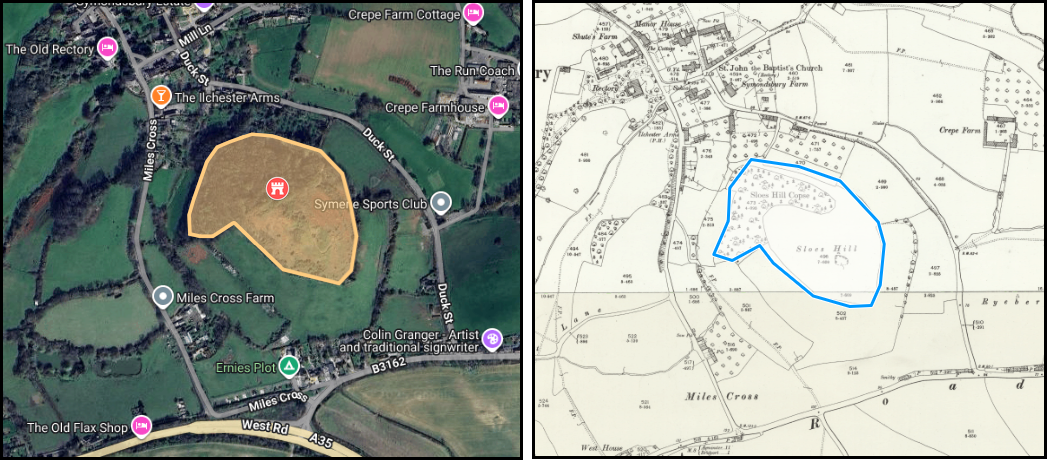
| probably located on Sloes Hill which is likely to be derived from eas hloes hyll which translates to the riverside refuge on the hill |
|
|
Exeter | | 734 hides |
|---|
| The most likely location for this fort was the Roman fort in Exeter(Isca) |
|
|
| |
|---|
Halwell - 300 hides ▲ |
|---|
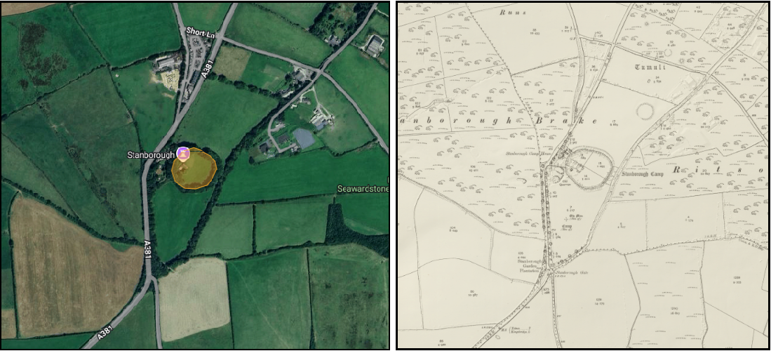
| The most likely location for this fort was the hill fort at Stanborough Camp, stane borough means the stone fortress, or the fortress on the roman road. The area covered by the image has a boundary of 345m and an area of 0.91 hectares. |
|
| |
|---|
Lydford - 140 hides ▲ |
|---|
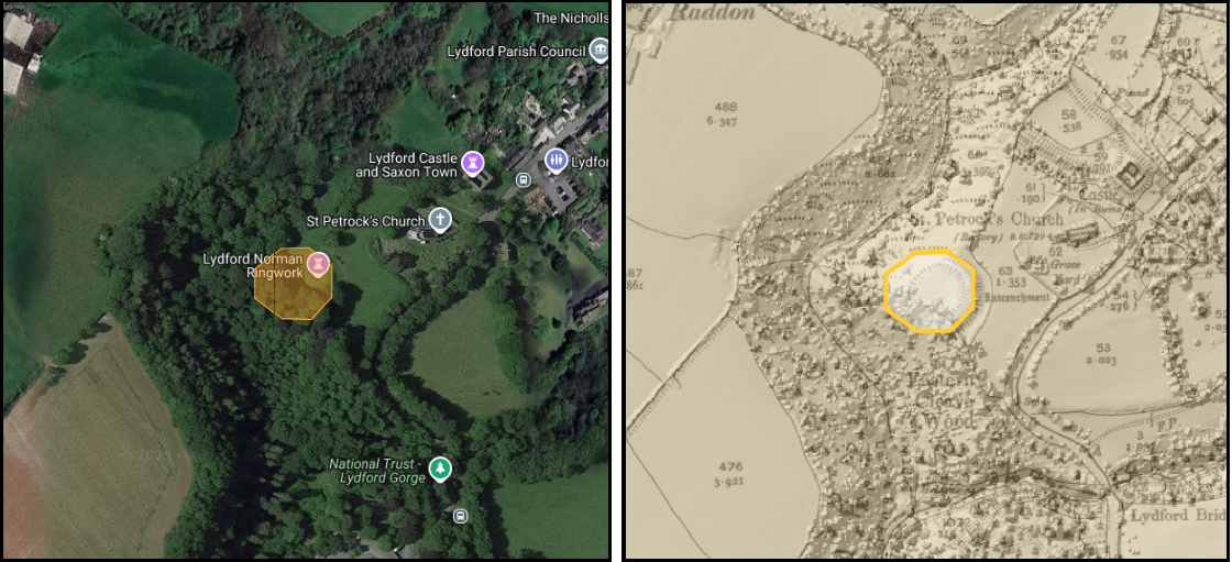
| The most likely location for this fort at Lydford is on ths small hill near to Eastern Cleve wood, on modern maps is marked as Lydford Norman ringwork. The area covered by the orange area has a boundary of 190m and an area of 0.27 hectares. |
|
|
Pilton | | 360 hides |
|---|
| The most likely location was an old iron age fort called RoboroughCamp who's name could have derived from the Saxon hleow borough meaning the old roman fort refuge |
|
|
|
Watchet | | 513 hides |
|---|
| The most likely location was an old iron age fort called Dawes Castle |
|
|
|
Axbridge | | 400 hides |
|---|
| The fort was probably on 'Callow Hill' which derives from Cal hleow Hyll meaning cabbage refuge hill |
|
|
| |
|---|
Lyng - 100 hides ▲ |
|---|
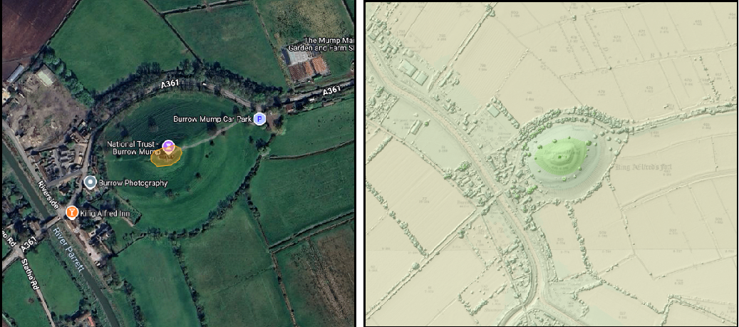
| This location must be near Athelney where Alfred the Great fled in 878AD this small fort is most likely located on Burrow mump - which was Burh hleow munt - meaning the fort refuge on the mound. The area covered by the image has a boundary of 117m and an area of 0.94 hectares |
|
| |
|---|
Langport - 600 hides ▲ |
|---|
| Meaning the long port as the sea reached here in the times of Wessex. The fort was most likely to be found in the location of Combe quarry but any evidence would be long since removed. |
|
|
Bath | | 1000 hides |
|---|
| The location for the Burh is in the old Roman center of the town. |
|
|
|
Malmesbury | | 1200 hides |
|---|
| Probably on the Holloway road translated from hoh hleow ǽ which means the promontory refuge on the river |
|
|
|
Cricklade | | 1500 hides |
|---|
| The fort was most likely in Cricklade - the name derives from crycc gelad which means the strong stick road, which refers to the well built straight Roman Ermin Street from Speen to Cirencester that crosses the Thames at this point. |
|
|
|
|
|
Wallingford | | 2400 hides |
|---|
| The fort was most likely in the town where the current town walls are. |
|
|
|
|
|
|
| |
|---|
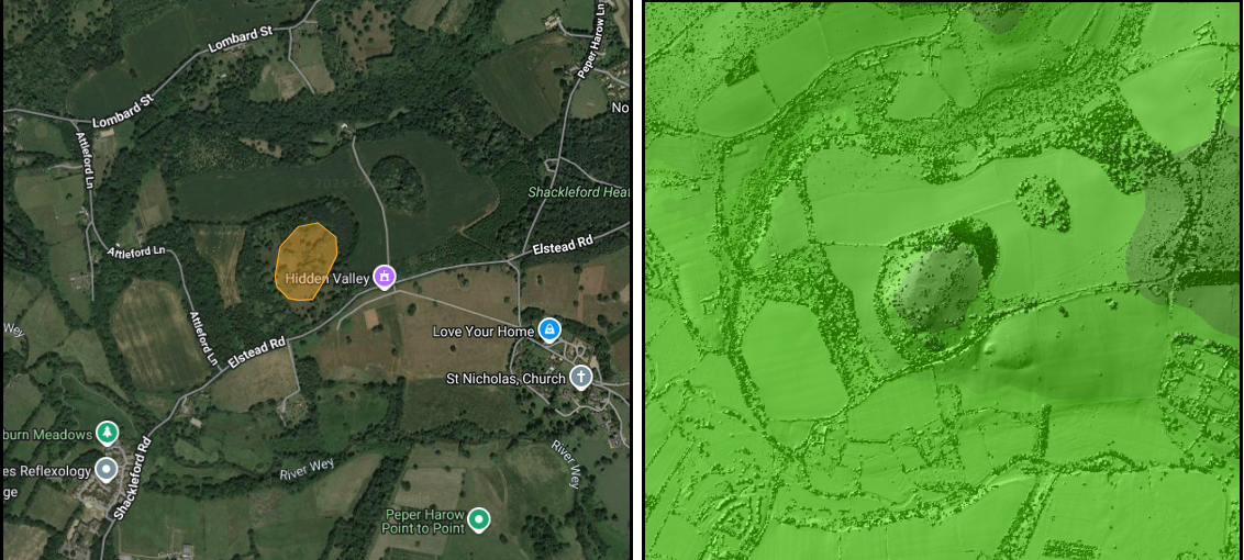
Eashing - 600 hides ▲ |
|---|
|
| | |
|---|
| The fort was most likely at Peper Harow as this derives from piþa hár hleów meaning the old pith refuge . The likely location is on Warren Hill just above the river Wey. The area covered by the image has a boundary of 690m and an area of 3.93 hectares. |
|
|
|
Southwark | | 1800 hides |
|---|
| The fort was probably somewhere near Crystal Palace or the high ground near Forest Hill, but modern buildings would have removed any evidence |
|
|
|
Worcester | | 1200 hides |
|---|
| The fort was most likely near Hallow park which derives from har hleów meaning the the old refuge |
|
|
|
Warwick | | 2400 hides |
|---|
| The fort was most likely near Woodloes farm which derives from wudu hleów es meaning the the people of the wood refuge |
|
;)

)
)
)
)
)
)
)
)
)
)
)