|
Norman knight | Anglo Saxon History

Search Pages |  | |
| Anglo Saxon Chronicles - 449AD(1) - Ypwinesfleot
(Henghest and Horsa) |
|---|
| | The entry from the Chronicles |
|---|
Original text
449. Her Mauricius 7 Ualentines onfengon rice 7 ricsodon .vii. winter. 7 On hiera dagum Hengest 7 Horsa from
Wyrtgeorne geleaþade Bretta kyninge gesohton Bretene on þam staþe þe is genemned Ypwinesfleot, ærest
Brettum to fultume, ac hie eft on hie fuhton.
Translation
449AD. This year Marcian and Valentinian assumed the empire,
and reigned seven winters. In their days Hengest and Horsa,
invited by Wurtgern, king of the Britons to his assistance,
landed in Britain in a place that is called Ypwinesfleot; first
of all to support the Britons, but they afterwards fought against
them.
| | The Venerable Bede's version of the invasion |
|---|
In the year of our Lord 449AD Marcian, the forty-sixth from Augustus, being made emperor with Valentinian, ruled the empire seven years. Then the nation of the Angles, or Saxons, being invited by the aforesaid king, arrived in Britain with three ships of war and had a place in which to settle assigned to them by the same king, in the eastern part of the island, on the pretext of fighting in defence of their country, whilst their real intentions were to conquer it.
Accordingly they engaged with the enemy, who were come from the north to give battle, and the Saxons obtained the victory. When the news of their success and of the fertility of the country, and the cowardice of the Britons, reached their own home, a more considerable fleet was quickly sent over, bringing a greater number of men, and these, being added to the former army, made up an invincible force.
The newcomers received of the Britons a place to inhabit among them, upon condition that they should wage war against their enemies for the peace and security of the country, whilst the Britons agreed to furnish them with pay.
Those who came over were of the three most powerful nations of Germany—Saxons, Angles, and Jutes. From the Jutes are descended the people of Kent, and of the Isle of Wight, including those in the province of the West-Saxons who are to this day called Jutes, seated opposite to the Isle of Wight.
From the Saxons, that is, the country which is now called Old Saxony, came the East-Saxons, the South-Saxons, and the West-Saxons. From the Angles, that is, the country which is called Angulus, and which is said, from that time, to have remained desert to this day, between the provinces of the Jutes and the Saxons, are descended the East-Angles, the Midland-Angles, the Mercians, all the race of the Northumbrians, that is, of those nations that dwell on the north side of the river Humber, and the other nations of the Angles.
The first commanders are said to have been the two brothers Hengist and Horsa. Of these Horsa was afterwards slain in battle by the Britons, and a monument, bearing his name, is still in existence in the eastern parts of Kent.
They were the sons of Victgilsus, whose father was Vitta, son of Vecta, son of Woden; from whose stock the royal race of many provinces trace their descent. In a short time, swarms of the aforesaid nations came over into the island, and the foreigners began to increase so much, that they became a source of terror to the natives themselves who had invited them.
Then, having on a sudden entered into league with the Picts, whom they had by this time repelled by force of arms, they began to turn their weapons against their allies. At first, they obliged them to furnish a greater quantity of provisions; and, seeking an occasion of quarrel, protested, that unless more plentiful supplies were brought them, they would break the league, and ravage all the island; nor were they backward in putting their threats into execution.
| | What does this mean |
|---|
If we look at the Saxon name 'Ypwinesfleot', pronounced 'Ip wines fleet' it is made up from three Saxon components 'Yp' which means 'Look Out', 'wines' which means 'wine' and 'fleot' a fleet[sea passage between two bodies of land].
This translates to 'the lookout place by the vineyard overlooking the Fleet' which means that the place is on a south facing hill (wine grows on south facing hills) and is on a 'Fleet' and has a lookout point.
This fits nicely with the location of modern Ebbsfleet on Thanet, as Thanet was an island at the time and has a 'fleet' between here and the mainland. It would make a good lookout point to Richborough and is south facing and is on a fleet.
This is also the location of Caesars fort from 43AD overlooking Pegwell bay, and would be a good place to isolate the Jutes from the mainland, but still provide them with a defensive location.
| | |
|---|
| Possible interpretation of the Chronicles |
|---|
If Vortigern had been pushed back to Richborough by Marcian and Valentinian then Ebbsfleet would also have been a good point for the Jutes to land as it would provide a blockade of the Wantsum Channel, give them a defensive fort, and a route to Richborough, Canterbury and along the coast.
Henghest and Horsa's base at Ebbsfleet, would have enabled them to sail into Canterbury, Rochester, Crayford and Purfleet, and that may have been the route taken as opposed to the yellow lines on the map below that follow Watling Street.
|
Map showing the Battles of Henghest and Horsa
|
|---|
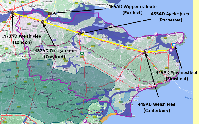
Map generated using Google My Maps 2024 - showing the Landscape, modern Counties and sea in 455AD
Please Note: this map is my interpretation of the Anglo Saxon Chronicles entries relating to Henghest, Horsa and Aesc and their take over of Kent, the purple line shows the modern Kent boundary.
The logic for the coastal changes and the Forest of Andredsweald can be viewed on the following pages:
Roman Roads in Britain
The Great Forest of Andredsweald - Anglo Saxon Chronicles
Landscape - Was the sea level in Saxon times at Pevensey 4 to 5 metres higher ?
Was the high tide in Saxon times 5 metres higher ? - the Wash
Landscape - The History of the Romney Marsh in maps
Roman Locations that have not been identified and roads that just terminate
|
|
|
|
|
| |
|
|
Local Interest
Just click an image |
|
|
|
|
|
|
|
|
|
|
|
|
| |
|
|
;)