| Roman Roads — A Reference Guide |
|---|
| How wide were Roman roads in Britain? ▲ |
|---|
|
Based on Ivan Margary's survey of Roman roads in Britain, road widths fall into six categories:
- Estate and farm tracks — under 18 feet (under 5.5 metres): Private roads serving individual farms, quarries or minor settlements. Single cart width only.
- Local and secondary roads — 18 to 23 feet (5.5 to 7 metres): Village connecting routes and minor public roads carrying local agricultural and trade traffic.
- Standard military width — 24 feet (7.3 metres): The prescribed legion engineering standard, equivalent to two Roman actus. Found across Britain wherever the army built to a fixed specification.
- Early military roads — 25 feet (7.6 metres): Invasion-period roads built during the Claudian conquest of 43 AD, found at Richborough, Dover and Seaford Head. The earliest Roman roads in Britain.
- Standard public roads — 26 to 32 feet (7.9 to 9.8 metres): The most common width for named inter-town roads. Wide enough for two carts to pass. The majority of Roman roads in Britain fall into this band.
- Major arteries — 33 feet and above (10 metres and above): Strategic routes serving fortresses, coloniae and major river crossings. Ermine Street north of Lincoln reaches approximately 16 metres including its agger shoulders.
|
Road classifications ▲ |
|---|
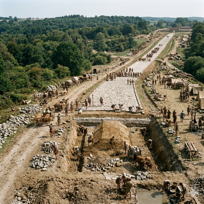 Roman law recognised four categories of road, distinguished by who built them, who maintained them, and who was permitted to use them.
Public highway — Via publica
The principal inter-city trunk roads of the empire. Named after the censor or consul who commissioned them, the state owned both the soil and the surface. These were the widest roads, typically six to twelve metres across, and were open to all traffic — military, commercial and civilian. Ermine Street and the Fosse Way are the principal British examples.
Military road — Via militaris
Built and maintained by the legions and funded by provincial or military governors, military roads prioritised speed of troop movement over comfort. Typically four to eight metres wide, they were restricted to military use, and civilians travelling them without authority could face penalties. In newly conquered territory, military roads often preceded the construction of full public highways.
Local and district road — Via vicinalis
Country cross-roads and connecting routes between villages and the main road network. Typically two and a half to four metres wide, they could be funded publicly or privately. The Laws of the Twelve Tables, dating to around 450 BC, set a minimum width of eight Roman feet on straight sections and sixteen on bends — wide enough for two carts to pass one another.
Private road — Via privata
Built and owned by private individuals to connect estates, farms or quarries to the wider network. The soil and right of way remained private property throughout. Construction quality varied enormously with the wealth of the owner, ranging from well-surfaced tracks to simple compacted earth paths.
|
| |
|---|
Construction layers ▲ |
|---|
|
Major public and military roads were built to a consistent layered specification. The sequence below describes the ideal; in practice, local materials and terrain dictated considerable variation. In Britain, gravel and local stone were far more common than the basalt paving of Italian roads.
Foundation — Pavimentum or statumen
A trench was dug down to firm ground and lined with large flat stones or compacted rubble. In soft or marshy ground, oak piles were driven first, topped with brushwood or timber planking, before stone courses were laid above.
Coarse rubble core — Rudus
Broken stone, brick or concrete rubble was packed into the trench above the foundation and compacted heavily using rollers and manual tamping. This layer provided the structural body of the road and distributed the load across the foundation below.
Fine binding layer — Nucleus
Finer gravel, sand or lime concrete was levelled above the rubble core to create a smooth, stable bed for the surface. This acted as a binder between the coarse core and the finished top surface.
Road surface — Summa crusta or glarea
On major roads the surface was paved with large polygonal stone slabs of silex or basalt, fitted so tightly that a Roman soldier's knife blade could not pass between them. On secondary routes, rammed gravel (glarea) was used instead — cheaper to lay and easier to repair, though requiring more frequent maintenance.
Raised embankment — Agger viae
The finished road had a crowned, elliptical cross-section designed to shed rainwater to the edges. On major routes this raised embankment, or agger, could stand one to two metres above the surrounding ground and measure thirteen to fifteen metres across overall. Many aggers survive as visible linear earthworks in the landscape today.
Drainage ditches — Fossae
Ditches were cut along each side of the road, sometimes as far as twenty metres from the road surface, to drain away surface water and define the full managed road zone. The material excavated from these ditches was typically used to build up the agger above.
|
| |
|---|
Typical dimensions and likely use ▲ |
|---|
|
Roman road widths varied considerably by type and location, and the width of a road is often the clearest indicator of its intended purpose. The legal minimum for a public road was set by the Laws of the Twelve Tables at eight Roman feet on straight sections (approximately 2.4 metres) and sixteen feet on bends (approximately 4.9 metres).
The full dimensions shown below are based on British roads surveyed by Ivan Margary in the 1950s and 1960s, and include the agger viae — the raised embankment and drainage shoulders to either side of the running surface. The carriageway figures given are estimates of the actual trafficked surface, calculated by removing approximately one third of the total recorded width to account for the agger. Margary's data reveals six meaningful width bands, one of which reflects a fixed military engineering specification rather than anticipated traffic volume.
Under 18 feet (under 5.5 metres) — carriageway under 12 feet (under 3.7 metres) — Estate tracks and private farm roads
The narrowest surviving roads were estate tracks and field paths — via privata in the Roman classification. At this width only a single cart could pass, and passing places would have been needed on any route of length. These roads served individual farms, quarries or minor settlements and were not part of the managed public network. Only fifteen roads in Margary's survey fall into this band, reflecting both how few minor private roads were built to a standard that left a recoverable earthwork and how many have been lost entirely to later cultivation.
18 to 23 feet (5.5 to 7 metres) — carriageway 12 to 15 feet (3.7 to 4.6 metres) — Local connecting routes and secondary public roads
Roads in this range were typically local connecting routes, the via vicinalis, linking villages and minor settlements to the main network. Wide enough for a single cart with room for a pedestrian or rider alongside, they would have carried local agricultural traffic, livestock movement and short-distance trade. In Britain many of these routes followed or incorporated pre-Roman trackways. Forty-seven roads in Margary's survey fall into this band, making it the most numerous category and confirming that the secondary road network was extensive.
24 feet (7.3 metres) — carriageway approximately 16 feet (4.9 metres) — Standard military construction width
Twenty-three roads in Margary's survey were recorded at exactly 24 feet — a clustering too precise to be coincidental. Twenty-four Roman feet is exactly two actus, the standard unit used by Roman military surveyors, and almost certainly represents a prescribed engineering specification applied by the legions rather than a width derived from traffic needs. A road built to this width could be set out quickly and consistently using standard survey tools regardless of the importance of the route, and this width appears across roads of quite varied status and location throughout Britain. Unlike the 25-foot roads, which cluster at specific early military sites, the 24-foot roads are distributed across the province as a whole, confirming that this represents a consolidated and standardised construction specification applied once the occupation was established rather than a response to the pressures of the invasion phase. It sits on the boundary between the secondary and public road bands and is best understood on its own terms as a military engineering module rather than a traffic-derived category.
25 feet (7.6 metres) — carriageway approximately 17 feet (5.2 metres) — Early military construction, pre-standardisation
Only four roads in Margary's survey were recorded at 25 feet, but their locations are highly significant. Three are in east Kent, forming a coherent early military network centred on Richborough — Rutupiae — the principal landing point of the Claudian invasion of 43 AD. One of these runs directly from Dover, Dubris, the home of the Classis Britannica fleet, to Richborough itself, connecting the two most critical points in the entire invasion operation. These are not roads built to serve a settled province — they are invasion infrastructure, laid down at speed in the first years of the occupation to link the fleet's harbour with the primary beachhead.
The fourth road is in east Sussex, running to Seaford Head where it joins a larger Roman road connecting Lewes and Pevensey. Seaford Head was the site of a scheduled Iron Age univallate hillfort, known in the post-medieval period as Burdyck Hill — the ditched fort — which has produced Romano-British pottery confirming Roman occupation. In the Roman period the coastline lay approximately a mile further south than today, suggesting a natural harbour at the Ouse mouth below the fort, with the elevated position commanding both the water approaches and the landward routes from the Weald. The Seaford Head road appears to form part of a distinct Sussex coastal military network connecting the Ouse valley and its Wealden iron traffic westward to Lewes and eastward to Pevensey and the Saxon Shore system, entirely separate from the Kent invasion infrastructure.
That both networks used a 25-foot road width most likely reflects the same underlying cause — early military construction before the 24-foot actus module became the established provincial standard, built under operational pressure by engineering units working independently in different parts of the newly conquered territory. Twenty-five feet has no obvious relationship to standard Roman surveying units, which supports the reading that it is a transitional width of the conquest and consolidation phase rather than a deliberate long-term specification.
26 to 32 feet (7.9 to 9.8 metres) — carriageway 17 to 21 feet (5.2 to 6.4 metres) — Standard public road between towns
The standard width for a managed public road between towns. At this width two carts could pass one another comfortably, which was the practical minimum for a functioning trade and communications route. Roads of this width would have carried regular commercial traffic, official government couriers using the imperial post system (the cursus publicus), and routine military movement. Thirty eight roads in Margary's survey fall into this band, and together with the 24-foot military standard they account for the great majority of named Roman roads in Britain.
33 feet and above (10 metres and above) — carriageway 22 feet and above (6.7 metres and above) — Major artery, strategic trunk road, or weathered agger
Roads in this band were either major strategic arteries serving fortresses, coloniae or key river crossings, or represent heavily weathered aggers on important routes where the earthwork has spread laterally over two thousand years of ploughing and erosion. At the lower end of the band — 33 to 40 feet — these are credible widths for significant military and commercial arteries capable of accommodating two lanes of cart traffic with space for infantry columns or drovers alongside. At the upper end, the two roads recorded by Margary at 57 feet almost certainly reflect agger spread rather than original construction width, giving a probable carriageway of around 38 feet or 11.6 metres — still a major road but one whose recorded width should be treated with caution. Ermine Street north of Lincoln, recorded at approximately 16 metres including its agger shoulders, falls into this band and reflects the road's role as the primary supply and communication route serving Lindum Colonia and the territories beyond the Humber.
|
| |
|---|
A note on regional variation ▲ |
|---|
|
The road widths given above reflect the general pattern across the Roman empire and are reliable as a guide to the likely purpose and status of any given road. However, a few regional differences are worth bearing in mind when using this table for comparison.
In Italy and the core western provinces, the principal consular roads into Rome frequently exceeded the upper figures given here, with full road zones sometimes stretching beyond twenty metres. In the eastern empire — Asia Minor, Syria and Egypt — roads were often built over or alongside much older Hellenistic, Persian or Phoenician routes, and widths were sometimes constrained by existing settlement patterns or terrain rather than Roman engineering preference.
In Britain specifically, quoted road widths often include the agger — the raised embankment that forms the road's shoulders — rather than the trafficked surface alone. A British road described as sixteen metres wide may have an actual running surface of six or seven metres, with the remainder made up of the agger slopes and drainage margins. When the agger is stripped out, British road surfaces drop by roughly a third and compress toward the lower end of each band, bringing them closely in line with excavated surface widths from North Africa and the eastern provinces. This strongly suggests that the Romans were building to a broadly consistent functional standard across the empire, and that the agger was a British adaptation to climate and terrain rather than any fundamental difference in road design or intent.
The categories above should therefore be treated as a working guide to function and status rather than a precise specification, and individual road measurements are best understood in the context of local terrain, building materials and the province in which they were constructed.
|
| |
|---|
Margary ▲ |
|---|
|
The tables below are drawn from Ivan Margary's Roman Roads in Britain (3rd edition, 1973), the definitive survey of the Roman road network in Britain. Margary recorded widths for 240 roads; a further 97 roads are included in his survey but their widths were not recorded, either because insufficient earthwork survived or because the route was known only from documentary or place-name evidence rather than physical remains. Those 97 roads are noted here as size unrecorded.
Grouped by classification band
| Classification | Total width (feet) | Total width (metres) | Carriageway (feet) | Carriageway (metres) | Number of roads |
|---|
| Size unrecorded | — | — | — | — | 97 |
| Estate tracks and private farm roads | Under 18 | Under 5.5 | Under 12 | Under 3.7 | 15 |
| Local connecting routes and secondary public roads | 18 to 23 | 5.5 to 7.0 | 12 to 15 | 3.7 to 4.6 | 47 |
| Standard military construction width | 24 | 7.3 | 16 | 4.9 | 23 |
| Standard public road between towns | 25 to 32 | 7.6 to 9.8 | 17 to 21 | 5.2 to 6.4 | 42 |
| Major artery, strategic trunk road, or weathered agger | 33 and above | 10 and above | 22 and above | 6.7 and above | 44 |
Raw Margary data
The figures below show the exact widths Margary recorded and the number of roads at each width, before grouping into classification bands. Widths are in English feet as recorded by Margary.
| Width (feet) | Width (metres) | Number of roads |
|---|
| Size unrecorded | — | 97 |
| 10 | 3.0 | 6 |
| 12 | 3.7 | 2 |
| 13 | 4.0 | 1 |
| 15 | 4.6 | 6 |
| 18 | 5.5 | 8 |
| 19 | 5.8 | 1 |
| 20 | 6.1 | 6 |
| 21 | 6.4 | 8 |
| 22 | 6.7 | 1 |
| 24 | 7.3 | 23 |
| 25 | 7.6 | 4 |
| 27 | 8.2 | 13 |
| 30 | 9.1 | 23 |
| 32 | 9.8 | 2 |
| 33 | 10.1 | 9 |
| 35 | 10.7 | 3 |
| 36 | 11.0 | 10 |
| 40 | 12.2 | 15 |
| 42 | 12.8 | 2 |
| 45 | 13.7 | 3 | | 57 | 17.4 | 2 |
|
| |
|---|
Map of Margary's Roman Roads ▲ |
|---|
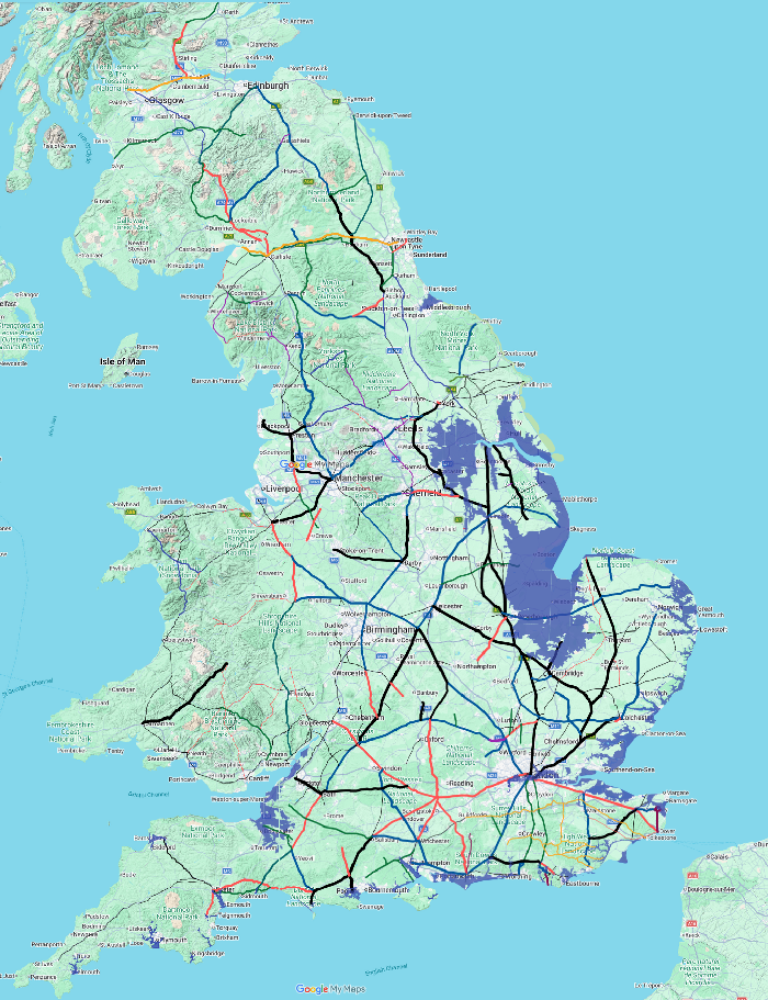 The map to the left shows the Margary roads with their sizes if known show in the following colours, please click on the map for a much more detailed image. This map also shows the tidal areas in blue that were raised in Roman times. For further details of the high tide levels please look at our Sea_levels_and_the_Pevensey_islands.
- Major artery, strategic trunk road - 33 feet and above (10 metres and above) - wide black line
- Standard public road between towns - 26 to 32 feet (7.9 to 9.8 metres) - wide blue line
- Early military construction - 25 feet (7.6 metres) - wide maroon line
- Standard military construction - 24 feet (7.3 metres) - wide red line
- Local connecting routes - 18 to 23 feet (5.5 to 7 metres) - wide green line
- Estate tracks -Under 18 feet (under 5.5 metres) - thin red line
- Width not recorded -??? - thin black line
Please Note In the South East there are roads shown as orange lines, these are from Margary's 'Roman ways in the Weald'.
|
Laws of the Twelve Tables (sometimes called the Twelve Tablets) ▲ |
|---|
|
The Laws of the Twelve Tables were Rome's first written legal code, produced around 450 BC. Before their creation, Roman law existed only as unwritten custom interpreted and applied by the patrician class, which left ordinary citizens — the plebeians — with little protection or recourse. The tables were a direct response to plebeian pressure for a transparent and consistent legal framework that applied equally to all citizens.
The code was inscribed on twelve bronze tablets and displayed publicly in the Roman Forum so that any citizen could read and know the law. The original tablets were destroyed when the Gauls sacked Rome in 390 BC, and what survives today is fragmentary — reconstructed from later quotations by Roman writers such as Cicero, who recalled memorising them as a schoolboy.
The twelve tables covered a broad range of civil and social matters. They dealt with court procedure and the rights of defendants, debt and the treatment of debtors, property ownership and inheritance, the rights of fathers over their households, rules governing burials and mourning, land boundaries, and relationships between citizens of different social standing. They also included the road width provisions relevant to this site — setting the minimum width of a public road at eight Roman feet straight and sixteen on bends.
The tables were not a radical or reforming document by modern standards. They largely codified existing practice and preserved many aristocratic privileges. But their significance lay in the act of writing the law down at all. Once published, the law could be studied, argued over and appealed to by anyone, which laid the foundation for the sophisticated Roman legal tradition that followed and which remains one of Rome's most enduring contributions to western civilisation. Much of modern European civil law, and by extension English contract and property law, traces its roots directly back to principles first set out on those twelve bronze tablets.
|
| |
|---|
Summary of Road Dimensions ▲ |
|---|
|
Under 18 feet (under 5.5 metres) — carriageway under 12 feet (under 3.7 metres) — Estate tracks and private farm roads
18 to 23 feet (5.5 to 7 metres) — carriageway 12 to 15 feet (3.7 to 4.6 metres) — Local connecting routes and secondary public roads
24 feet (7.3 metres) — carriageway approximately 16 feet (4.9 metres) — Standard military construction width
25 to 32 feet (7.6 to 9.8 metres) — carriageway 17 to 21 feet (5.2 to 6.4 metres) — Standard public road between towns
33 feet and above (10 metres and above) — carriageway 22 feet and above (6.7 metres and above) — Major artery, strategic trunk road, or weathered agger
|
|
;)


)
)