| The Variable Ocean: Roman Locations that have not been identified
and roads that just terminate
|
|---|
| |
|---|
Introduction |
|---|
| Introduction ▲ |
|---|
|
Roman roads were built to connect settlements, forts, and ports. When a road simply stops — not at a known town or fort, but apparently in the middle of nowhere — it raises an obvious question: what was it heading for?
This page collects examples of Roman roads in Britain and Northern Europe that terminate at locations which make little sense today, but which would have sat directly on the coastline if the high tide level in Roman and early Saxon times was approximately 4 to 5 metres higher than it is now. The implication in each case is the same: the road was heading for a harbour or port that is now either inland, silted up, or lost beneath later sediment.
The evidence for a higher tidal range is set out on the Pevensey and Wash pages, and is now supported by a 2026 paper in the Journal of Coastal Research. This page provides a third, independent line of evidence.
| | |
|---|
Why I am using the high tide/sea level as 4.5 metres higher ▲ |
|---|
I have been working on the translations of Saxon Settlement names for about 20 years now and I think I can explain a lot of the names by setting the high tide line on the maps to about 4.5 metres in Early Saxon/Late Roman times.
My logic for this is found on these pages:
The Variable Ocean: Was the high tide level in Saxon times at Pevensey at about 4.5 metres ?
The Variable Ocean: Was the high tide level in Saxon times in the Wash 4 to 5 metres higher ?
| Roman roads that just appear to terminate inland ▲ |
|---|
The Roman European roads described are from Digital Atlas of the Roman Empire and the UK ones are from our maps of Ivan D Margary taken from his book 'Roman Roads in Britain'.
Please note that the darker shaded areas show the sea at approximately 4.5 metres above current levels, these maps are now reasonably accurate as i use National Library of Scotland maps to plot and Google maps to display. To see an adjustable version please go to flood.firetree.net and choose 5 metres in the pull down.
| | |
|---|
Margary road M38 - Smallburgh to Denver ▲ |
|---|
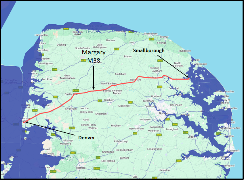 Margary describes the Smallburgh end of the road as
This east-west road has only recently been recognised as a major route, although part of it on Marsham Heath has long been known. It appears to be the obvious eastward continuation of the Fen Road(25) from Durobrivae and Peterborough through Denver to the east coast, perhaps to the Roman site at Caistor next Yarmouth, or to a port now destroyed by the severe coastal erosion, but it has not yet been identified east of the river Ant at Smallburgh
If the high tide level was approximately 4.5 metres higher in Roman times, Smallburgh would have sat directly on the coast — which also explains why Margary could find no continuation of the road eastward. There was nowhere further to go: it had reached the sea.
| | |
|---|
Margary M51 - Ilchester to Puriton ▲ |
|---|
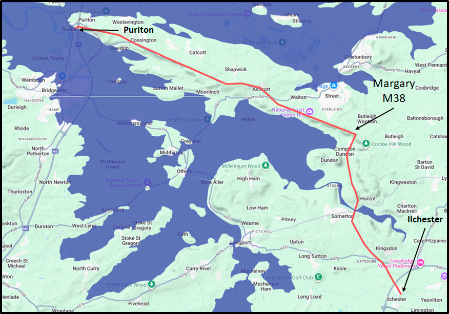 Margary describes the Puriton end of the road as
At Bawdrip after crossing the railway, it is lost for 1/2 mile but then reappears as a lane past the north side of Knowle Hall grounds, and continuing straight along the ridge to its very tip at Dunhall, near Puriton, no doubt to connect to a small harbour on the estuary of the river Parrett.
Margary himself suggested the road was heading for a small harbour on the River Parrett estuary — he just could not identify it. At a tidal level 4.5 metres higher, Dunhall would have been a substantial coastal site. This may have been one of the more significant Roman ports on the Bristol Channel, now entirely landlocked.
| Margary M27 - Lincoln to Burgh Le Marsh ▲ |
|---|
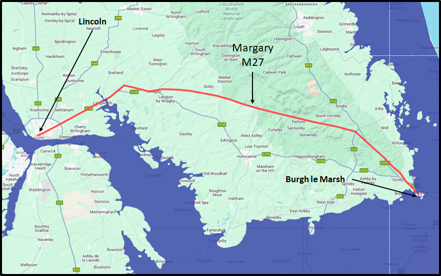 Margary describes the Burgh Le Marsh end of the road as
Then beyond Candlesby Hill a hedgerow in the same line marks it up to the east side of Welton vicarage, but beyond this there is no trace, until on the north west outskirts of Burgh le Marsh, the lane leading back to Orby marks the line for 1/2 mile into Burgh.
This is the last certain portion of the alignment, which if continued beyond Burgh would have crossed the marshes to the coast.
At a high tide level of 4.5 metres above current levels, Burgh le Marsh would have sat on the shore of the Wash. It is quite possible it served as either a Roman port or a lookout station for vessels entering the estuary — the road exists precisely because there was something worth reaching at its end.
| | |
|---|
Margary M273 - Stixwould to Saltfleet ▲ |
|---|
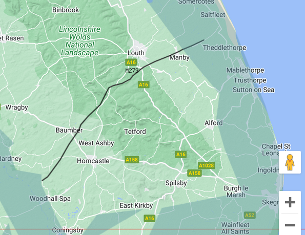 M273 Stixwould to Saltfleet
It was probably continued south-westward near Stixwould on the edge of the fens, and may have had a connection through Woodhall Spa and North Kyme with the Sleaford road but this is uncertain.
This is the eastward description of this road.
At a high tide level 4.5 metres higher than today, Stixwould would have been a coastal location, explaining both the terminus of the road and its otherwise puzzling relationship to the fenland edge.
| | |
|---|
Margary M58b - Grantham(Saltersford) to Donington ▲ |
|---|
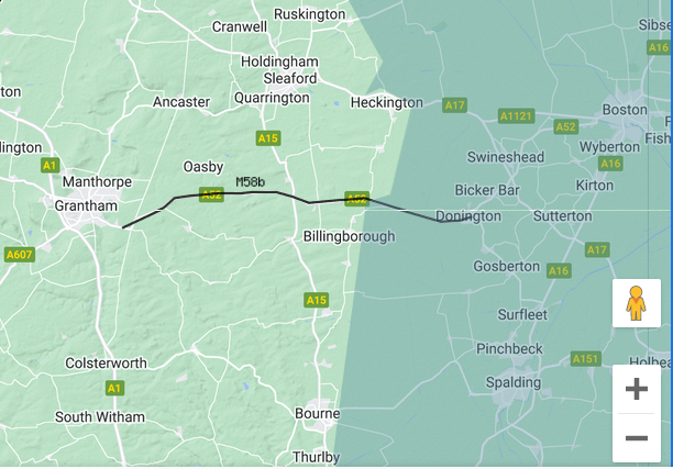 M58b Grantham(Saltersford) to Donington
After passing Swaton, where it turns a little to the south-east, it crosses the belt of fen land and bears the name Bridge End Causeway, reaching Donington just beyond, and no definite course has been traced onwards.
The name Bridge End Causeway is itself suggestive — a causeway implies a raised road crossing regularly flooded or tidal ground. At a high tide level 4.5 metres higher than today, Donington would have been at the water's edge, and the causeway would have been the only reliable approach to it across tidal marsh.
| | |
|---|
Margary M332 - Roudham Heath to Hockwold ▲ |
|---|
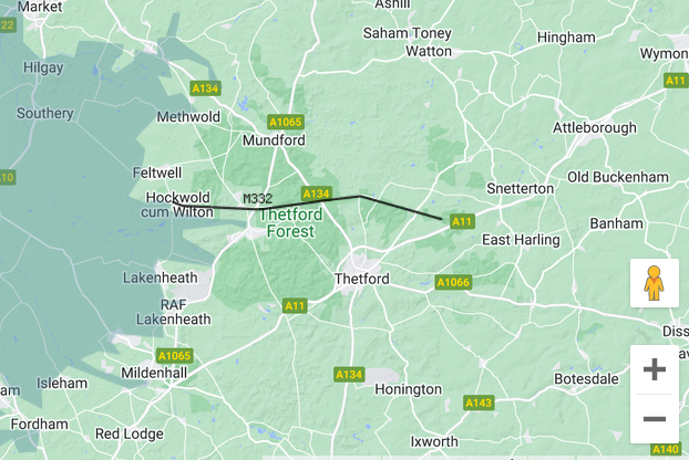 M332 Roudham Heath to Hockwold
The present road deviates through the village, but the line is continued by a hedgerow and footpath until, just beyond, the present road resumes the line and continues very straight for 3 1/2 miles to Hockwold and through the village right to the edge of the fenland area
At a high tide level 4.5 metres higher than today, Hockwold would have sat on the fenland coast. The road runs dead straight to the very edge of the fen — it was not abandoned mid-route, it arrived at its destination.
| | |
|---|
Margary M23b - Cambridge to Littleport ▲ |
|---|
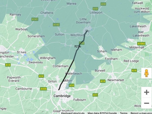 M23b Cambridge to Littleport
The Ely road returns to the line for the last 1/2 mile to the town, and it is likely that this line was followed by the Roman road right on to Littleport, rather to the west of the centre of Ely
At a high tide level 4.5 metres higher than today, Littleport would have been partially or wholly submerged, suggesting the road's true destination was not Littleport itself but a now-lost harbour or crossing point just before it. Ely, which the road passes through, would have been a true island — as its name, derived from el æg (eel island), has always suggested.
| | |
|---|
And now some in Northern Europe ▲ |
|---|
|
The same principle that explains the British road termini applies equally to the northern coast of Gaul. The Channel and the North Sea share the same tidal system, and if sea levels were 4 to 5 metres higher in Roman and early Saxon times on the British side, the same conditions prevailed on the Continental shore. Several military stations listed in the Notitia Dignitatum — a late Roman administrative document compiled around 420 AD — remain unidentified, which is considerably less puzzling if their locations were coastal ports that are now several kilometres inland. The three stations listed under the Dux Belgicae Secundae are particularly instructive.
| | |
|---|
Notitia dignitatum ▲ |
|---|
|
The Notitia Dignitatum — the List of Offices — is one of the most remarkable administrative documents to survive from the late Roman world. Compiled around 420 AD, it lists the military and civil commands of both the Western and Eastern empires in considerable detail, from the imperial court down to individual garrison units at remote frontier posts. It is unique in the breadth of its coverage and remains an invaluable source for understanding the organisation of the late Roman army.
By the time it was compiled, Roman forces had already withdrawn from Britain. The document nonetheless records two separate commands responsible for the northern coast of Gaul, both forming part of the Saxon Shore system that had originally been designed to protect both sides of the Channel.
The first of these commands — under the Dux Belgicae Secundae, the Duke of Belgica Secunda — controlled the coastline of the province roughly between the estuaries of the Scheldt and the Somme. His headquarters was at Portus Aepatiaci. Under his command were three garrison units, recorded in the original Latin as follows:
Sub dispositione viri spectabilis ducis Belgicae secundae:
Equites Dalmatae, Marcis in litore Saxonico.
Praefectus classis Sambricae, in loco Quartensi siue Hornensi.
Tribunus militum Neruiorum, Portu Epatiaci.
Which translates as:
Under the command of the distinguished Duke of Belgica Secunda:
Dalmatian horsemen, at Marcae on the Saxon Shore.
Commander of the Sambrian fleet, at the place of Quartense or Hornes.
Tribune of the Nervii soldiers, at Portus Aepatiaci.
Two of these three locations — Marcae and Locus Quartensis — remain unidentified by modern scholarship. Marcae is noted as lying explicitly in litore Saxonico, on the Saxon Shore itself, making its non-identification all the more puzzling. Portus Aepatiaci, as the Duke's headquarters, is conventionally placed at Étaples, though as argued below this identification presents difficulties. Although not listed in the Notitia, the major port of Gesoriacum — Boulogne — would also have fallen under the Duke's command, as it had been the principal base of the Classis Britannica until 296 AD.
| | |
|---|
The Saxon Shore in Northern Gaul ▲ |
|---|
|
The same principle that explains the British road termini applies equally to the northern coast of Gaul. The Channel and the North Sea share the same tidal system, and if sea levels were 4 to 5 metres higher in Roman and early Saxon times on the British side, the same conditions prevailed on the Continental shore.
Several military stations listed in the Notitia Dignitatum — a late Roman administrative document compiled around 420 AD — remain unidentified, which is considerably less puzzling if their locations were coastal ports that are now several kilometres inland. The three stations listed under the Dux Belgicae Secundae are particularly instructive. Read together they form a coherent coastal patrol chain running from Belgium to the Seine estuary, each station roughly a day's sail apart.
| Order | Fort | Proposed Location | Notes |
|---|
| 1 | Oudenburg | Belgian coast | Archaeologically confirmed |
| 2 | Marcae | Bergues | On coast at 4.5m higher sea level |
| 3 | Gesoriacum/Bononia | Boulogne | Confirmed Roman port |
| 4 | Locus Quartensis | Abbeville | Fourth station, headland between Somme and Scardon |
| 5 | Portus Aepatiaci | Pont-Audemer / Saint-Samson | Risle/Seine confluence, Duke's headquarters |
| | |
|---|
Marcae — Dalmatian cavalry on the Saxon Shore ▲ |
|---|
|
Marcae is described in the Notitia Dignitatum as a Saxon Shore station garrisoned by Dalmatian cavalry — Equites Dalmatae — and is explicitly noted as lying in litore Saxonico, on the Saxon Shore itself. Despite this, its location remains unidentified, with candidates such as Marquise and Marck most commonly suggested in the literature.
Applying the 4.5 metre tidal hypothesis to the map of northern France suggests a more northerly candidate. Bergues, on the coastal plain between Dunkirk and Cassel, sits approximately halfway between the confirmed Saxon Shore forts at Oudenburg and Boulogne. At a sea level 4.5 metres higher than today it would have sat directly on the coast with a well-protected harbour to its south — consistent with a Saxon Shore garrison on the literal shoreline as the Notitia explicitly states.
The name Bergues derives from the Dutch groene berg — green hill — sharing the same Proto-Germanic root as the Old English burgh, a fortified elevated position. The hill at Bergues would have provided both a natural defensive position and a clear vantage point over the coastal approaches, exactly what a cavalry garrison needed for rapid response to seaborne raiders.
More significantly, Bergues sits on the Roman road from Cassel — Castellum Menapiorum, the fortified hilltop capital of the Menapii tribe. Critically, this road does not continue beyond Bergues to the modern coast at Dunkirk. It terminates at Bergues. This is precisely the pattern seen repeatedly in the British road evidence on this page — a Roman road that ends not at a known town or fort but at a location that makes little sense today, until the 4.5 metre tidal hypothesis is applied. At higher sea levels Bergues was the coast. The road ended there because that was where the land met the sea.
A cavalry garrison at Bergues therefore served a dual purpose: watching the Saxon Shore for incoming raiders, and defending the road approach to Castellum Menapiorum from coastal attack. The road connecting them was both a supply route for the garrison and the very corridor that seaborne raiders would have used to strike inland toward the Menapian capital — making Bergues the critical defensive point between the coast and the tribal centre it protected.
The use of Dalmatian cavalry rather than local troops is itself consistent with Roman practice — garrisoning non-local units on a coastline to prevent local loyalties from compromising the defence. The Menapii, whose capital lay just a few kilometres up the road, would not have been policing their own coastal approaches.
The conventional candidates of Marquise and Marck may simply reflect the assumption that the coastline has always looked as it does today. Once that assumption is removed, and the strategic relationship between the coast and Castellum Menapiorum is taken into account, Bergues presents a more coherent identification — a coastal garrison at the foot of the road to the tribal capital, positioned to defend both the shore and the settlement it protected.
The name Bergues derives from the Dutch groene berg — green hill — but the element berg shares its Proto-Germanic root with burgh and the late Latin burgus, terms denoting fortified positions. More significantly, the medieval core of Bergues is still described by the French term castrum — the Latin word for a Roman fort — preserved in the ring of streets that follow the line of the original medieval moat around the town centre. The town's fortifications took a distinctive figure-of-eight form, with one lobe encircling the main town and a second encircling the Groenberg and its abbey — the hill given its own separate enclosure within the wider defensive circuit. Baldwin II fortified the site in 882 AD against Norman raiders, almost certainly building on Roman foundations that had already made the Groenberg the obvious defensive position on this stretch of coast.
| | |
|---|
Locus Quartensis sive Hornensis — the lost harbour of the Somme fleet ▲ |
|---|
| Detail |
|---|
| Fleet | Classis Sambrica — Fleet of the Somme |
| Name meaning | The fourth station, or the headland station |
| Evidence | Somme silting documented — sea 12km further inland in Roman times |
The name Locus Quartensis sive Hornensis repays closer examination. Locus simply means place or station. Quartensis most likely derives from quartus — fourth — with the standard -ensis suffix denoting association with a place. It therefore means the fourth station, implying a numbered sequence of shore forts along this stretch of coast of which this was the fourth. Counting northeast to southwest — Oudenburg, Marcae, Boulogne, and then Abbeville — the numbering fits precisely. Sive Hornensis — or alternatively of the Horn or Headland — appears to describe the same site from a geographical rather than administrative perspective, hornum being a common Latin and Germanic term for a promontory still visible in modern place names such as Herne, Horn and Hornsey. The double name may reflect two different naming conventions in simultaneous use — one administrative, one topographical.
Abbeville is the most compelling candidate. It sits on a headland between the River Somme and the River Scardon, which means it satisfies both parts of the name simultaneously — it is the fourth station in the numbered sequence, and it is the headland location on this stretch of coast. A fleet base on such a promontory would have had sheltered anchorage available on either flank, with two separate navigable rivers giving access both inland and to the open sea.
The silting of the Bay of Somme is a documented historical process entirely independent of the tidal hypothesis. The sea has receded approximately 12 kilometres from Abbeville since Roman times through natural silting rather than any dramatic coastal event. A fleet base that made perfect operational sense on a broad tidal estuary in 420 AD is now an inland town, its harbour long since filled with sediment.
| | |
|---|
Portus Aepatiaci — the Duke`s headquarters ▲ |
|---|
| Detail |
|---|
| Commander |
Dux Belgicae Secundae |
| Garrison |
Milites Nervii |
| Rivr |
Risle, confluence with Seine |
| Roman roads |
One passing through, one terminating at the site |
| Conventional identification |
Étaples |
| Proposed identification |
Pont-Audemer / Saint-Samson-de-la-Roque |
Portus Aepatiaci is mentioned in the Notitia Dignitatum as being in Belgica Secunda, garrisoned by the Tribunus militum Nerviorum — the Tribune of the Nervian soldiers. Its location remains uncertain. It has conventionally been identified with Étaples at the mouth of the River Canche, but Étaples sits between Boulogne and Abbeville in the coastal sequence — placing it third in the numbered chain rather than fifth, directly contradicting the Quartensis argument. A more westerly location beyond the Somme is required.
The Digital Atlas of the Roman Empire places a Roman site at Saint-Samson-de-la-Roque, at the mouth of the River Risle where it meets the Seine, 13 kilometres downstream from Pont-Audemer. At a tidal level 4.5 metres higher than today the Risle estuary would have been a broad navigable inlet extending well upstream past Pont-Audemer, making Saint-Samson and Pont-Audemer two components of the same tidal harbour system rather than two distinct locations. This two-part arrangement — an outer anchorage at the river mouth and an inner fortified base at the tidal limit — is a pattern the Romans used at other major installations, providing both open water access and a defensible inland position.
Saint-Samson would have served as the outer anchorage, giving direct access to the Seine estuary and the open Channel beyond. Pont-Audemer, 13 kilometres upstream at the natural tidal limit, would have been the inner base — the point where tidal water met the road network. Two Roman roads are associated with this site: one passing through, connecting the wider network between the coast and Rouen, and one terminating at the point itself. In Roman road logic a terminating road leads to something of significance — a port, a fort or a major supply depot. Roads do not end at nothing. The combination of a through road and a dedicated spur is the characteristic signature of a major Roman installation served by both a coastal supply route and an inland connection.
The name Pont-Audemer may itself preserve a memory of the site's Roman tidal character. The conventional etymology derives Audemer from the Germanic personal name Audemar — a Norman attribution of the 10th century or later. But an older reading of au de mer — at the sea, or bridge over the sea — is linguistically plausible and geographically precise. If the settlement was originally described as pont au de mer, the bridge at the tidal water, and Norman arrivals in the 10th century heard this as the familiar personal name Audemar, that would be a completely natural linguistic evolution well documented in Norman place name history. A bridge sitting at the tidal limit of a broad sea inlet would have been the defining geographical feature of the site — exactly the kind of feature that gives a settlement its name.
The garrison of milites Nervii — soldiers of the Belgic Nervian tribe, whose homeland centred on the Sambre valley and Hainaut well to the northeast — is consistent with the Roman practice of deliberately stationing units away from their home territory. Nervian soldiers are attested as far afield as Rough Castle on the Antonine Wall in Scotland and Whitley Castle in Northumberland, confirming that the Nervii were regularly used as garrison troops at permanent installations across the northwestern empire.
As the headquarters of the Dux Belgicae Secundae, Portus Aepatiaci needed to be both defensible and accessible by sea. Pont-Audemer with its outer anchorage at Saint-Samson satisfies both requirements — sheltered tidal water giving access to the Seine and the Channel, a naturally defensible position between two arms of the Risle, road connections inland to Rouen and along the coast in both directions, and a position at the westernmost end of the Saxon Shore chain that placed the Duke's headquarters squarely between the Channel approaches and the strategically vital Seine corridor leading to the heart of Roman Gaul.
| | |
|---|
XXXVIII. Dux Belgicae secundae. ▲ |
|---|
This is the original latin from the Notitia dignitatum
Sub dispositione viri spectabilis ducis Balgicae secundae:
Equites Dalmatae, Marcis in litore Saxonico.
Praefectus classis Sambricae, in loco Quartensi siue Hornensi.
Tribunus militum Neruiorum, Portu Epatiaci.
Which translates into
Under the command of the distinguished Duke of Belgica Secunda:
Dalmatian horsemen, at Marcae on the Saxon Shore.
Commander of the Sambrian fleet, at the place of Quartense or Hornes.
Tribune of the Nervii soldiers, at Portus Aepatiaci.
This is extract from Wikipedia
The Notitia also includes two separate commands for the northern coast of Gaul, both of which belonged to the Saxon Shore system. However, when the list was compiled, in c. 420 AD, Britain had been abandoned by Roman forces.
The first command controlled the shores of the province Belgica Secunda (roughly between the estuaries of the Scheldt and the Somme), under the dux Belgicae Secundae with headquarters at Portus Aepatiaci
Marcae (unidentified location near Calais, possibly Marquise or Marck), garrisoned by the Equites Dalmatae. In the Notitia, together with Grannona, it is the only site on the Gallic shore to be explicitly referred to as lying in litore Saxonico.
Locus Quartensis sive Hornensis (probably at the mouth of the Somme), the port of the classis Sambrica ("Fleet of the Somme")
Portus Aepatiaci (possibly Étaples), garrisoned by the milites Nervii.
Although not mentioned in the Notitia, the port of Gesoriacum or Bononia (Boulogne-sur-Mer), which until 296 was the main base of the Classis Britannica, would also have come under the dux Belgicae Secundae
| Map of Northern France and Belgium with the sea at 4.5 metres High Tide. ▲ |
|---|
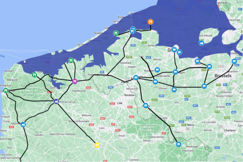
This map is derived from the Digital Atlas of the Roman Empire
From this map of Northern France and Belgium we can see that the coastline has changed significantly from Roman times, this map also shows Roman roads that cannot be traced beyond the 4.5 metre high tide level.
Also from this map it would seem that Marcae was either at modern Ardres, Arques or Burgues, as these would all have been on the coast.
| | |
|---|
Conclusion ▲ |
|---|
|
The roads on this page were not built carelessly or abandoned without reason. Roman engineers constructed roads to connect places that mattered — administrative centres, military stations, and above all, ports. A road that terminates in what is now open fenland, or a quiet market town well inland, is not a road that was never finished. It is a road whose destination has been erased by centuries of coastal change.
Taken together — the British road termini, the Fenland causeways, the unidentified Gaulish shore forts of the Notitia Dignitatum, and the place-name evidence from the Pevensey Levels and the Wash — the pattern is consistent and geographically widespread. These are not isolated anomalies. They are precisely what you would expect to find if the coastline of Roman and early Saxon Britain and northern Gaul bore little resemblance to the one we know today.
The 2026 paper by Dr Roger Higgs in the Journal of Coastal Research now provides geological confirmation of a rapid 4-metre marine transgression centred on 430–500 AD. What the Roman roads suggest, the place names encode, and the geology confirms: the world these people inhabited looked fundamentally different from ours, and the sea that shaped it has since retreated far enough to hide the evidence in plain sight.
| | |
|---|
Links to other Variable Ocean Documents ▲ |
|---|
|
The pages below show links to documents that reference pages concerning The Variable Ocean.
These pages discuss the apparent historical Sea Level changes that have been found across the UK, their implications and the creation of a theory of Sea Level changes that incorporates these observations, this in turn has developed into a geological framework that explains earthquakes, subduction zones and supervolcanoes.
For the individual pages please click on the links, new documents will be auto populated as and when these
are written.
| |
|
|
;)


)
)
)
)