| Battle of Hastings 1066AD - E - The Sailing - St Valerie to Pevensey |
|---|
| List of Contents |
|---|
| Introduction ▲ |
|---|
On the night of 29 September 1066, William the Conqueror's fleet of nearly 700 ships was somewhere in the middle of the English Channel — in darkness, with no moon, carrying several thousand men and several hundred horses.
Then it stopped.
The Carmen de Triumpho Normannico records that William ordered his fleet to anchor in open water and wait for dawn before completing the crossing. For nearly a thousand years, nobody has been quite sure where.
This page works out the answer. The method is straightforward: take the Carmen's timings, establish the fleet's average speed, and then apply a physical constraint that has been largely overlooked — the length of a Viking anchor chain. At approximately 11 metres, as established by the only surviving example from Ladby in Denmark, a Viking vessel could anchor safely only where the water depth was 6 metres or less. Combined with the higher tide levels of Norman times, that constraint eliminates most of the English Channel entirely.
What remains, after working through every shoal and sandbank between St Valérie and the English coast, is a single candidate: the Colbart Ridge.
This page also revisits the New Romney incident — why two ships from a fleet of nearly 700 ended up on the wrong stretch of coast, what received them so hostilely that William destroyed the town after the battle, and how that episode connects directly to the storm that damaged the fleet at Dives two weeks earlier.
The crossing was not simply a matter of waiting for a south wind. It was a logistical problem solved under considerable pressure — and the route it took was determined as much by the depth of the sea as by the direction of the wind.
| Documentary Evidence ▲ |
|---|
The documents that give us any information for the journey from St Valerie to Hastings/Pevensey are as follows.
Bayeux Tapestry- 'to(towards) Pevensey'
William Sails from Normandy in 1066AD
The big ships are loaded with fighting troops and
the smaller ones carry provisions, horses etc |
The armada sails towards modern Pevensey(Pevenesæ)
please click
here to visit Reading Museum for further details of Britains Bayeux Tapestry.
|
The Carmen de Triumpho Normannico
(usually known as the Carmen - this extract comes from Kathleen Tyson's translation)
You give the order and they strike for the greater depths of the sea,
Hitherto confined, the ships spread along the coast evenly,
And form themselves into a tidy fleet,
The days already short, the setting sun now inclines,
When your flagship sets the course,
When the dark night's gloomy shadows overspread the sky,
And the veiled moon refuses you service,
You fill the waves otherwise with torches reddish glow,
Just as the stars fill the sky in place of the fallen sun.
As many are the ships, so many lights you disperse.
The sails rule a straight course through the sea.
But cautious lest dark imposes losses,
And contrary wind and current disturb the sea,
You order the fleet to halt course, form up and drop anchor.
On the open sea you moor offshore.
And as the sun casts its rays over the horizon,
You order the sails set to the wind to make way
While the ships raise anchor.
The third hour of the day overspreads the earth
Since leaving the sea behind when you seize a sheltered strand.
The land belonging to you had been stripped of terrified tenants.
You rejoice as you and yours seize a peaceful arc of strand.
The Ecclesiastical History of Orderic Vitalis
(this extract comes from Marjorie Chibnall's translation)
When at last by Gods grace the favorable wind sprang up in answer to so many prayers, the duke, impatient to set out, called all his men forthwith to the ships and commanded them to set sail with courage.
So the Norman army crossed the sea on 29th September, the night when the universal church celebrates the feast of St Michael the archangel, and reaching the coast of England where they met no opposition, gladly came ashore.
They took possession of Pevensey and Hastings and gave them into the charge of chosen soldiers as a base for the army and shelter to the fleet.
Roman de Rou - Master Wace
(this extract comes from Edgar taylor's translation)
The duke placed a lantern on the mast of his ship, that the other ships might see it, and hold their course after it. The ships sailed to one port; all arrived and reached the shore together; together cast anchor, and ran on dry land; and together discharged themselves. They arrived near Hastings, and their each ship ranged by the other's side.
Chronicle of Florence of Worcester
and he had moored his fleet at a place called Pevensey.
Chronicle of Henry of Huntingdon
William Duke of Normandy, had landed on the south coast, and had built a fort at Hastings.
Anglo Saxon Chronicles – A,B,C,D,E and H
A.D. 1066.(Version D)
Meantime Earl William came up from Normandy into Pevensey on the eve of St. Michael's mass; and soon after his landing was effected, they constructed a castle at the port of Hastings.
Chronicles of Battle Abbey
The duke, therefore, with a prodigious army, and attended by the divine favour, arrived safely near the castle called Pevensey.
The soldiers leaped joyfully upon English ground at intervals along the shore.
| Not a lot to go on - The Carmen ▲ |
|---|
It looks like the Carmen gives the only detailed report, so lets use that
The days already short, the setting sun now inclines,
(So they are starting to sail after 12:00)
When the dark night's gloomy shadows overspread the sky,
(and they sail until the sun sets - sunrise 05:56 ->sunset 17:51 in Sept 1066)
And the veiled moon refuses you service,
(no moon so very dark)
You fill the waves otherwise with torches reddish glow,
Just as the stars fill the sky in place of the fallen sun.
(So navigation by the stars may have been possible)
As many are the ships, so many lights you disperse.
The sails rule a straight course through the sea.
But cautious lest dark imposes losses,
And contrary wind and current disturb the sea,
(This may imply that the fleet moved over a shoal with the current changing and lapping around the ships)
You order the fleet to halt course, form up and drop anchor.
(So they anchor up not too late so lets assume no more than about 20:00)
On the open sea you moor offshore.
(Mooring offshore in the Channel is a bit awkward as the anchor lines for Viking vessels would not have been more than about 11 metres)
A Viking age anchor has been found in Ladby(Denmark) the anchor is 1.26 m long and 0.83 m wide is made mostly of iron and equipped with an iron anchor chain which is estimated to have been ca. 11 m long.
The original Ladby anchor can still be seen today in situ – in its original resting place – in the remains of the ship-grave at Vikingemuseet Ladby.
The majority of the sea in the channel is deeper than 11 metres, and as the high tide was probably about 4 metres higher in Norman times then the only places they could anchor were the few banks and shoals in the Channel that are currently no more than 7 metres deep.
Continuing to England
And as the sun casts its rays over the horizon,
(up and sailing before sunrise, so possibly 05:00)
You order the sails set to the wind to make way
While the ships raise anchor.
The third hour of the day overspreads the earth
Since leaving the sea behind when you seize a sheltered strand.
(so about 4 hours sailing and arrive about 09:00)
The land belonging to you had been stripped of terrified tenants.
You rejoice as you and yours seize a peaceful arc of strand.
| | |
|---|
Overall Journey Time ▲ |
|---|
The Fleet leaves after midday, so assume 12:00 and anchors up at about 20:00 which means they sail for about 8 hours.
They weigh anchor at about 05:00 and arrive by 10:00 so another 5 hours sailing.
Their overall sailing time is from 12:00 to the following 10:00 about 22 hours overall.
Viking ships could sail at an average of about 7 mph, which would give an overall distance of 56 miles(90 km) from St Valerie to the anchor point, then a further 35 miles(56 km) to Pevensey. So the overall journey would be a maximum of 91 miles(146 km).
As an aside, when a fleet in the middle ages anchored in the sea, all the ships were tied together, with a few throwing out anchors, this made a large platform that people could walk across, and in the case of the Norman Invasion probably allowed the horses to be fed and watered while at anchor.(sorry cant find any images to illustrate this).
| The New Romney issue ▲ |
|---|
There are reports of Romney being destroyed after William defeats Harold that may also have some bearing on the route.
Master Wace
Of so large a fleet with so many people, only two ships were in any peril, and those perhaps from being overloaded.
The Duke placed a guard in Hastings, from the best of his knights, so as to garrison the castle well, and went thence to Romenel, to destroy it utterly, because some of his people had arrived there , I know not by what accident, and the false and traitorous had killed them by felony. On that account he was very wroth against them and grievously punished them for it.
Orderic Vitalis
When his own dead had been given honorable burial he advanced to Romney, defeated the garrison and avenged the slaughter of some of his men. They had landed there in error and had been routed in the ensuing battle by the fierce defenders, with terrible losses on both sides.
My Comments
It seems unlikely they would have landed in Romney by error as 700 ships were sailing together, it is much more likely that the vessels were taking on water and they needed to reach the nearest shore. From Master Wace only two ships were in any peril, and those perhaps from being overloaded so these may have been the vessels that arrived at New Romney.
| | |
|---|
Viking Anchor rope/chain length ▲ |
|---|
The length of the Ladby Ship Anchor chain was about 11 metres, this would mean a maximum depth of water that could be anchored in was about 6 metres.
Further details of the Viking Longboat and Transport ships is on our Battle of Hastings 1066AD - C - Ships - Drekka, Snekkja and Knarr pages.
If we now look at the sandbanks/shoals in the Channel we can see where the anchorage could have been.
| Shoals and Sandbank in the English Channel (La Manche) ▲ |
|---|
To try and define where possible anchorage places for the Fleet we now look at the Shoals and Sandbanks in the English Channel that could be used to anchor the fleet. It would have been very risky anchoring near to the shore in the dark, so we will only look at the places in the Channel itself.
There is a high probability that the high tide level could have been at least 4 metres higher in Norman times - see (~~Sea_Level_Rises~~), so will comment against the individual shoals below.
Details of shoals and sandbanks in the English Channel
extracted from https://www.sea-seek.com/en/Pas-de-Calais-Dover-Straight.
The Varne (50°58'N., 1°20'E.), a dangerous steep-to and narrow shoal, lies 11 miles NW of Cap Griz-Nez and extends for about 8 miles in the middle of the traffic lane heading SW in the Pas de Calais TSS. It is possible to pass on both sides of the bank. Strong tide rips occur in the vicinity of this shoal and a heavy sea breaks over it during bad weather. This shoal has a least depth of about 3m and is marked by lighted buoys to the W, E, and S.
If the high tide level was the current level, then this shoal would have been about 3 metres deep,well within the length of anchor chain at the time, so we can't eliminate this shoal.
If the high tide level was higher, then this shoal would have been about 7 metres deep, just about the maximum length of anchor chain at the time, so we can't eliminate this shoal.
The Ridge (Le Colbart) (50°53'N., 1°20'E.), a dangerous steep-to and narrow shoal, lies about 10 miles W of Cap Gris-Nez. It extends for about 10 miles and forms a natural separation between the traffic lanes of the TSS. This shoal, which is composed mostly of sand with mud and shells in places, has a least depth of 1.5m and is marked by lighted buoys. The sea breaks heavily on this shoal, especially with the wind against the tidal current.
If the high tide level was the current level, then this shoal would have been about 2 metres deep,well within the length of anchor chain at the time, so we can't eliminate this shoal.
If the high tide level was higher, then this shoal would have been about 5 metres deep, so this is a comfortable anchor length, so we can't eliminate this shoal.
Bullock Bank (50°45'N., 1°05'E.), a steep-to and narrow shoal, lies about 20 miles WSW of Cap Gris-Nez. It extends for about 7 miles and is marked by a lighted buoy. This bank has a least depth of 14m and is usually marked by strong tidal rips.
If the high tide level was at the current level, then this shoal would have been about 14 metres deep, this is much deeper than the normal anchor could go to, so this shoal should BE ELIMINATED.
If the high tide level was higher, then this shoal would have been about 18 metres deep, this is much deeper than the normal anchor could go to, so this shoal should BE ELIMINATED.
Les Ridens (50°45'N., 1°18'E.), lying about 13 miles SW of Cap Gris-Nez, is an area consisting of several shoals. These shoals are formed of sand, gravel, and shells disposed irregularly on a rocky bottom. The area has a least depth of 13m and is marked by a lighted buoy. The sea breaks heavily on this area and strong eddies occur in bad weather.
If the high tide level was at the current level, then this shoal would have been about 13 metres deep, this is much deeper than the normal anchor could go to, so this shoal should BE ELIMINATED.
If the high tide level was higher, then this shoal would have been about 17 metres deep, this is much deeper than the normal anchor could go to, so this shoal should BE ELIMINATED.
Bassurelle (50°38'N., 1°05'E.), a sandy shoal with a least depth of about 7m, lies 24 miles SW of Cap Gris-Nez. Strong eddies and a dangerous sea occur during bad weather, especially with the wind against the tidal current, in the vicinity of this shoal. The shoal extends for about 9 miles and the depths over it frequently change.
If the high tide level was at the current level, then this shoal would have been about 7 metres deep, so this is a bit tight for an anchor length, but is close so we can't eliminate this shoal.
If the high tide level was higher, then this shoal would have been about 11 metres deep, this is deeper than the normal anchor could go to, so this shoal should BE ELIMINATED.
Vergoyer (50°33'N., 1°15'E.), a narrow sand bank, lies 23 miles SSW of Cap Griz-Nez. It extends for about 15 miles and is marked by lighted buoys. A shoal patch, with a least depth of 4.2m, lies near the NE extremity. The E side of this sand bank is steep-to, while the W side slopes gradually. In bad weather the sea breaks over this bank.
If the high tide level was at the current level, then this shoal would have been about 4 metres deep, so we can't eliminate this shoal.
If the high tide level was higher, then this shoal would have been about 9 metres deep, so this is a bit tight for an anchor length, but is close so we can't eliminate this shoal.
Bassure de Baas (50°27'N., 1°20'E.), a narrow bank of sand and shells, lies with its N end located about 4.5 miles SSW of Cap Griz-Nez. This bank has mostly depths of less than 7m and extends for about 35 miles. During bad weather the sea breaks heavily over the entire bank. Numerous unmarked wrecks lie in the channel leading between the mainland coast and the N part of Bassure de Baas.
If the high tide level was at the current level, then this shoal would have been about 7 metres deep, so this is a bit tight for an anchor length, but is close so we can't eliminate this shoal.
If the high tide level was higher, then this shoal would have been about 11 metres deep, this is deeper than the normal anchor could go to, so this shoal should BE ELIMINATED.
Battur, a shoal extending for about 9 miles, lies parallel with and SE of the SW extremity of Bassure de Baas. It has a least depth of 8.9m and is formed of sand, gravel, and shells. During strong W winds the sea breaks heavily on this shoal.
If the high tide level was at the current level, then this shoal would have been about 9 metres deep, this is much deeper than the normal anchor could go to, so this shoal should BE ELIMINATED.
If the high tide level was higher, then this shoal would have been about 13 metres deep, this is deeper than the normal anchor could go to, so this shoal should BE ELIMINATED.
Sandettie (51°15'N., 2°00'E.), a shoal bank extending for about 15 miles, lies with its SW end located 11 miles NNW of Calais. It has a least depth of 5m and is marked by lighted buoys.
If the high tide level was at the current level, then this shoal would have been about 5 metres deep, so this is fine for anchor length,so we can't eliminate this shoal.
If the high tide level was higher, then this shoal would have been about 9 metres deep, so this is a bit tight for an anchor length, but is close so we can't eliminate this shoal.
and this is taken from https://www.sxbrcmapping.org.uk/ifca/mSNCICitation.php?SiteRef=13.
The Royal Sovereign Shoals lie between 10-13 km ENE of Beachy Head, and 8-10 km off Langney Point, NE of Eastbourne. The reef covers an area of about 1 km2 and is marked by a buoy (the Royal Sovereign) at its southern end. The reef rises from a surrounding sea bed of gravel, muddy sand and sand, and the area is sµbject to strong tidal currents which reach 2.6 knots at spring tides. Its minimum depth is about 4.8 metres.
If the high tide level was at the current level, then this shoal would have been about 5 metres deep, so this is fine for anchor length,so we can't eliminate this shoal.
If the high tide level was higher, then this shoal would have been about 9 metres deep, so this is a bit tight for an anchor length, but is close so we can't eliminate this shoal.
| Map showing the Shoals and Sandbanks in the English Channel ▲ |
|---|
So we are looking for areas which are no more than 7 metres down for safe anchorage points.
The bathymetry map shown below shows the depth of the sea and all the sandbanks and shoals in the English Channel today(2024) together with their shallowest depth in metres.
Yellow is deepest, with the shading going to red for the shallower water.
The shape of the shoals may have been different in Norman times, but these changes would probably be minimal, however the high tide level could have been up to 5 metres higher - see ~~Sea_Level_Rises~~.
| 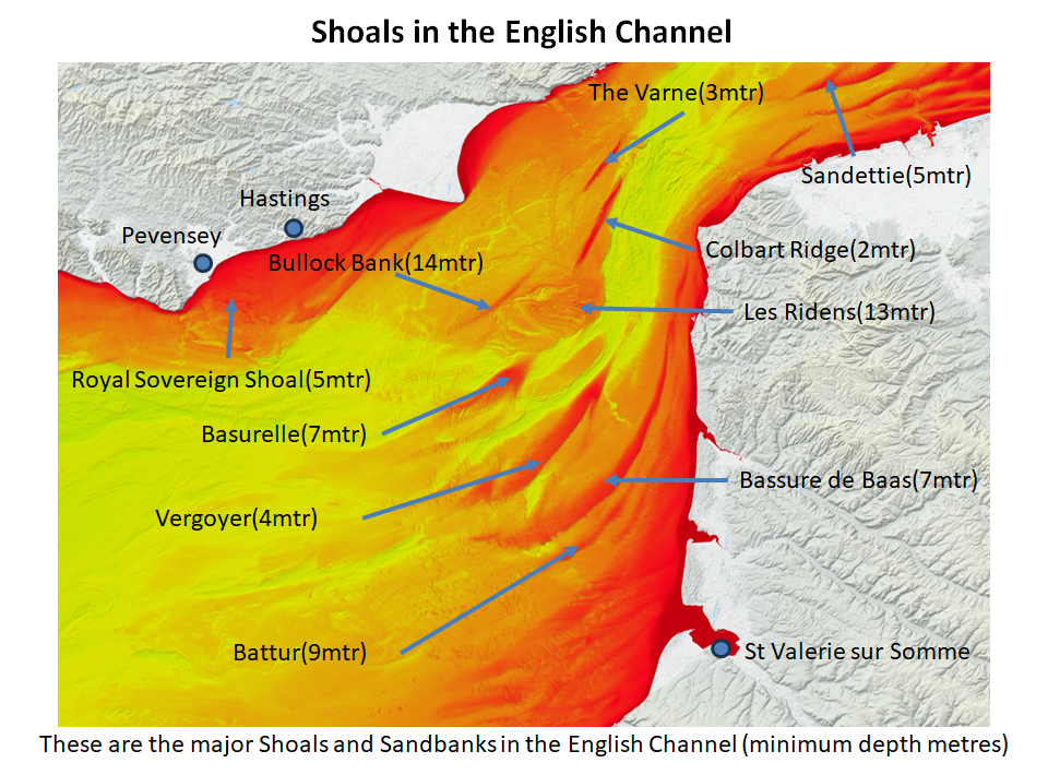
This map is derived from the European Marine Observation and Data Network please click the map for their website.
The banks and shoals that are currently less than 7 metres down are Basurelle, Vergoyer, The Varne, Colbart Ridge, Sandettie and the Royal Sovereign shoal. The first four of these are sand and shingle banks, so are the most likely.
The Royal Sovereign shoal consists of rocky outcrops, so is much more dangerous to anchor over and is less likely to be the anchorage point.
The Basurelle is also probably unlikely as the anchor chains would have been at full stretch to hold the fleet.
The Sandettie which is much too far north if you are landing at Pevensey or Hastings, but might work if you were sailing to Dover.
This just leaves The Varne and the Colbart Ridge as potential anchorages.
The Varne is further up the channel than the Colbart Ridge so would have taken more time to get to or from so it was probably not here either.
This just leaves the Colbart Ridge as the most likely anchor point.
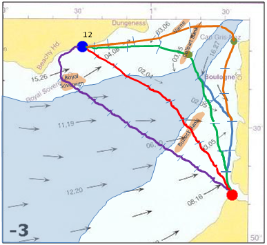
| Routes to cross the Channel ▲ |
|---|
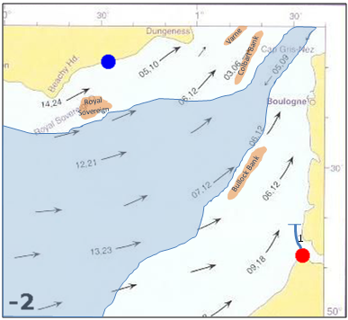
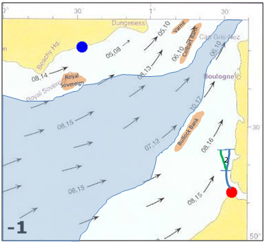
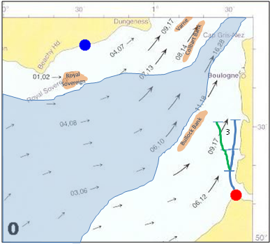
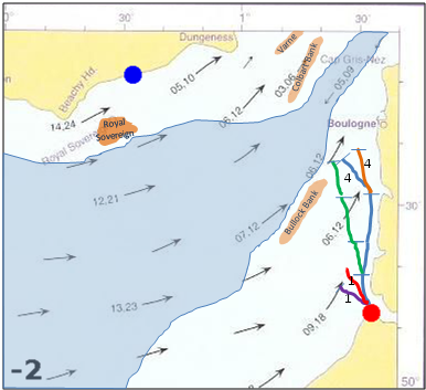
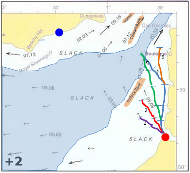
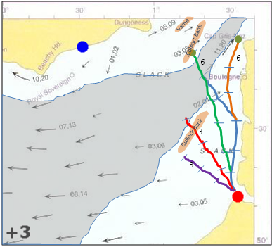
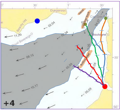
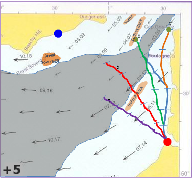
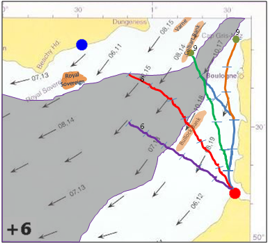
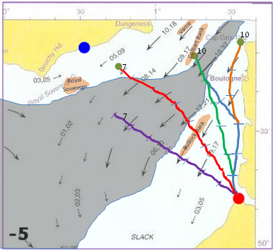
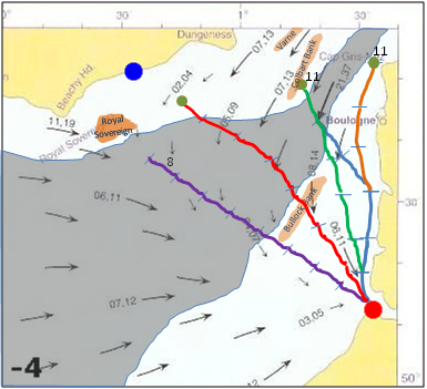
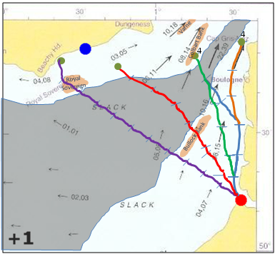
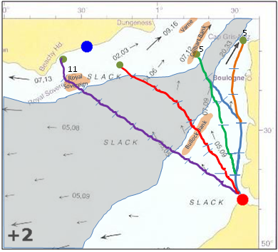
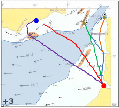
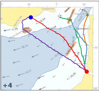
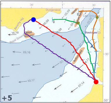
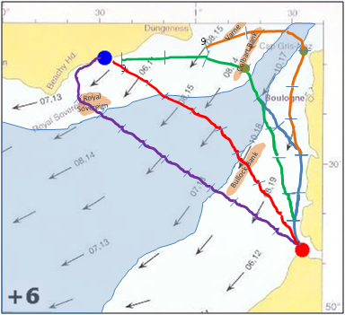
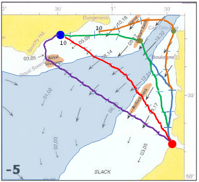
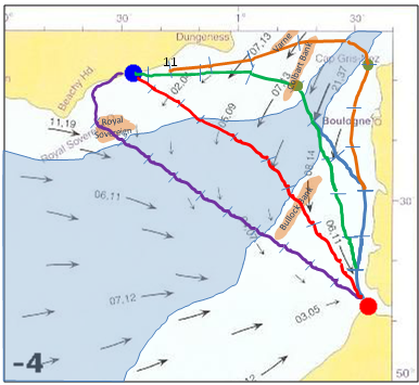
To see how they could sail across channel we need firstly to look at the tides that flow through the Channel, these maps have been extracted
from pages provided by
VisitMyHarbour.com. The red dot shows the invasion starting point at St Valerie sur Sommme, the blue dot
shows the approximate landing point at Hastings.
| |
| ❮ |
1 / 24
2 / 24
3 / 24
4 / 24
5 / 24
6 / 24
7 / 24
8 / 24
9 / 24
10 / 24
11 / 24
12 / 24
13 / 24
14 / 24
15 / 24
16 / 24
17 / 24
18 / 24
19 / 24
20 / 24
21 / 24
22 / 24
23 / 24
24 / 24
❯ | | |
|
|
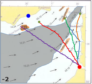
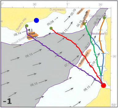
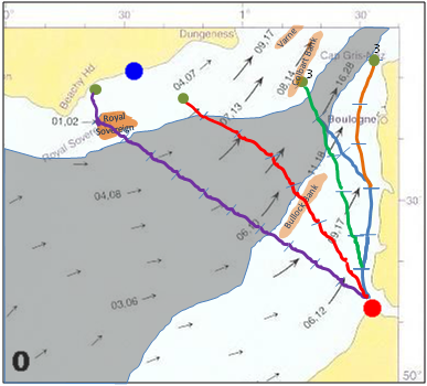
The slideshow above shows the tides as they rotate from 2 hours before high tide at Dover for 24 hours.
The map slides show deep water in blue, which is at least 50 metres deep so unsuitable for anchoring a fleet.
As you go through the slides which are 1 hourly intervals based around the high tide at Dover you will see the plots extending as the fleet moves.
the distances shown are based on a viking ship sailing at 7mph + or - the tidal flows. The numbers against each segment of the plot show the time in
hours using a 24 hour clock.
| Final Map ▲ |
|---|
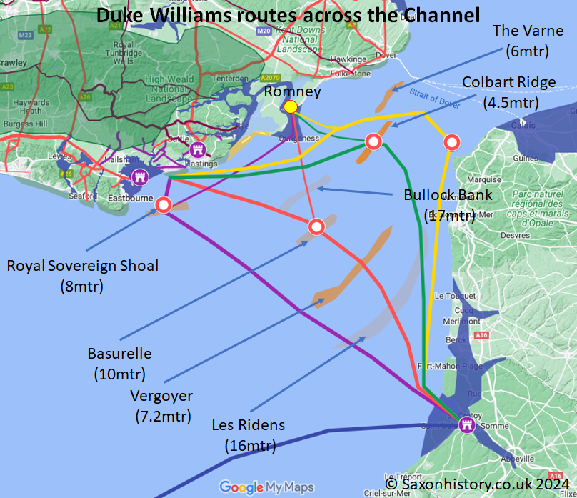
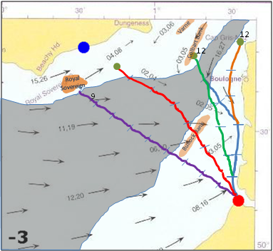
This map is derived from Google My Maps to show possible routes across the Channel, the darker the shoal, the shallower it is at its shallowest point.
There are four plots to show potential differing routes from St Valerie to Hastings.
The main ports are shown, Pevensey, Hastings and Romney in England and St Valerie in Northern France.
The coloured dots over the various shoals show where the fleet would need to anchor overnight, they are all set to leave St Valerie at 13.00, sail until 18.00 and then anchor.
- Green plot showing the most likely route as this matches with the Carmen time description.
- Yellow plot showing a second route which stays nearer to land, which makes it more likely the ships will be blown onto the French Cliffs between St Valerie and Boulogne, but will not have time to get to Hastings/Pevensey within the time available.
- The red plot is a theoretical route across the Channel, but the vessels arrive too early for the Carmen Description and anchoring on the Basurelle may have been difficult due to the depth of the shoal, however this is a possibility.
- The purple plot is based on an article by Christine and Gerald Grainge in which they describes a direct route across the Channel to Beachy Head(our thanks to Johnathan Starkey who brought this to our attention), this does however show the fleet arriving at Pevensey about 7am which appears too soon according to the Carmen.
Click here for the full Grainge article
The red line along the French Coast near Bolougne shows the dangerous chalk cliffs.
Please Note tide tables for 1066 are unknown, but the flows imply the only likely routes.
The various sand/shingle banks in the Channel where the fleet could have anchored are shown together with their depth in 1066.
The red circles show possible locations where the sea is shallow enough for fleet anchoring locations.
The thick coloured lines show potential routes for the fleet to take to reach Britain, the thin coloured lines show the routes the few ships that landed at New Romney would have had to have taken.
Further information can be found on the Admiralty Map of 1915 on Wikimedia.
| | |
|---|
Conclusion ▲ |
|---|
The Carmen provides the only detailed account of the crossing itself, and working through its timeline gives us a total sailing time of roughly 22 hours — approximately 8 hours from St Valerie to an overnight anchorage, then 5 hours onward to the English coast the following morning.
Applying the constraint of the Viking anchor chain length (approximately 11 metres) against the known shoal depths in the Channel, and adjusting for the higher tide levels of Norman times, eliminates all but two candidate anchorage points — the Varne and the Colbart Ridge. The Varne sits further up the Channel and would have added unnecessary distance to the crossing. This leaves the Colbart Ridge as the most probable overnight anchorage.
The New Romney incident now fits naturally into this picture. Master Wace reports that only two ships were in peril, and that these were perhaps overloaded. This is not a coincidence. As argued on the previous page (Battle of Hastings 1066AD - D - Sailing - Dives sur Mer to St Valerie), the storm that drove the fleet from Dives to St Valerie most likely destroyed around 83 ships — predominantly the slower, non-oared supply and transport vessels. The troops and horses survived largely intact, but the fleet arrived at St Valerie critically short of food, fodder and equipment.
Before William could sail for England, replacement supplies had to be sourced from the surrounding area — which explains the weeks of delay at St Valerie that chronicles attribute solely to waiting for a favourable wind. He was also waiting until he had enough provisions to sustain an invasion.
When the fleet finally sailed, some ships were dangerously overloaded precisely because the vessels that should have been carrying that cargo had already been lost in the storm. The two ships that broke away and landed at New Romney were not simply unlucky — they were probably among the most heavily laden in the fleet, struggling in the Channel conditions, and made for the nearest shore when they could no longer keep up. The hostile reception they received from the local population, and William's subsequent punitive destruction of New Romney after the battle, is consistent with vessels arriving unannounced and out of formation rather than as part of a planned landing.
The chain of events from Dives to Pevensey therefore forms a single connected story: the storm destroyed the supply ships, the surviving fleet was overloaded at St Valerie, two of those overloaded ships were lost at New Romney, and the rest anchored on the Colbart Ridge before completing the crossing to Pevensey the following morning.
| Select Bibliography: The Crossing & Anchorage ▲ |
|---|
Primary Sources (as cited on this page)
Anglo-Saxon Chronicle, Version D. Anno 1066.
Chronicles of Battle Abbey.
Florence of Worcester. Chronicon ex chronicis.
Henry of Huntingdon. Historia Anglorum.
Orderic Vitalis. The Ecclesiastical History. Translated by Marjorie Chibnall. Oxford Medieval Texts. Oxford: Clarendon Press, 1969.
Tyson, Kathleen, trans. Carmen Widonis – The First History of the Norman Conquest. Granularity Press, 2018.
Wace, Master. Roman de Rou. Translated by Edgar Taylor. London: William Pickering, 1837.
William of Poitiers. Gesta Guillelmi. Edited and translated by R. H. C. Davis and Marjorie Chibnall. Oxford Medieval Texts. Oxford: Clarendon Press, 1998.
Nautical Technology & Anchoring Depth
Ladby Ship Anchor. Vikingemuseet Ladby, Denmark. Museum documentation.
→ Source for 11m anchor chain length and ~6m maximum anchoring depth.
Hydrographic Data – Channel Shoals
“Pas de Calais – Dover Strait.” sea-seek.com. Accessed 2025. https://www.sea-seek.com/en/Pas-de-Calais-Dover-Straight.
→ Modern depths for The Varne, The Ridge, Bullock Bank, Les Ridens, Bassurelle, Vergoyer, and Bassure de Baas.
Palaeogeography & Sea-Level Change (SaxonHistory.co.uk)
“Sea Levels and the Pevensey Islands: A logical discussion of why the high tide mark in Anglo Saxon times was 5 metres higher using Pevensey in Sussex to explain.” SaxonHistory.co.uk. Last updated 22 January 2026. https://saxonhistory.co.uk/FORMS-Page-Builder.php?Pg=Sea_levels_and_the_Pevensey_islands.
→ Primary source for the +4–5m medieval sea-level hypothesis applied to the Pevensey Levels. Combines place-name evidence, flood modelling, and peer-reviewed scientific corroboration (Higgs 2026).
Higgs, Roger. “English Coastal Archaeological Evidence of a Fifth-Century (Dark Ages) 4-Meter Sea-Level Rise in 70 Years, Portending a Similar Rise Imminently.” Journal of Coastal Research, January 2026. https://jcr.kglmeridian.com/view/journals/coas/42/1/article-p165.xml
→ Peer-reviewed scientific corroboration of the +4m sea-level rise in the 5th century, cited and summarised on the Pevensey Islands page.
|
|
|
|
;)


)
)