| The Roman Gallic Empire 260AD - 274AD |
|---|
| Introduction ▲ |
|---|
|
The Gallic Empire is not a footnote to Roman history — it is a warning that Rome chose not to hear. Between 260 AD and 274 AD, the western provinces of the empire functioned as an entirely separate state, with their own emperors, their own coinage, and their own military command. It lasted fourteen years. It governed well. And when it was finally destroyed, the method of its destruction created the conditions for the next breakaway — the one that built Pevensey.
To understand Carausius, you need to understand the Gallic Empire first. The western provinces had the legions, the iron, the timber, and the coastline. Whoever controlled those controlled the means of resistance to Rome. That lesson was demonstrated once between 260 and 274. It was demonstrated again between 286 and 296. Rome suppressed both rebellions but never resolved the underlying problem.
| | |
|---|
The Crisis of the Third Century — the world that made the Gallic Empire possible ▲ |
|---|
|
The Gallic Empire did not emerge from nowhere. It was a product of the most sustained period of Roman instability in the empire's history — the Crisis of the Third Century, which ran roughly from 235 AD to 284 AD. During those fifty years the empire saw more than fifty emperors or claimants, most of whom died violently. The frontiers were under simultaneous pressure from the Franks and Alemans on the Rhine, the Goths on the Danube, and the resurgent Sassanid Persians in the east. The central government lurched from one military emergency to the next, and the provinces increasingly had to look to local commanders for protection rather than waiting for a distant emperor to respond.
It was in this context that the western provinces concluded, in 260 AD, that they were better governed from Cologne than from Rome. They were probably right.
| | |
|---|
Postumus — the founder ▲ |
|---|
|
The Gallic Empire was established by Marcus Cassianius Latinius Postumus, a capable military commander who had been governing the Rhine frontier provinces. In 260 AD, following the catastrophic capture of Emperor Valerian by the Sassanids — the first time a sitting Roman emperor had been taken prisoner — the empire effectively lost its head. Postumus moved quickly. He declared himself emperor of a breakaway state covering Gaul, Britannia, Germania, and initially Hispania, and established his capital at Colonia Agrippina — modern Cologne.
What is striking about Postumus is how well he governed. He stabilised the Rhine frontier at a moment when it was genuinely close to collapse, drove back the Frankish and Alemannic incursions that had been ravaging Gaul, and maintained the administrative structures of the Roman state within his territory. His coinage was of good quality, his civil administration functional, and his military effective. The provinces did not follow him out of revolutionary sentiment — they followed him because he was competent and present at a time when the central empire was neither. He survived for nine years, which by the standards of the Crisis of the Third Century was a remarkable achievement.
He was assassinated in 269 AD by his own troops, reportedly after refusing to allow them to sack the city of Mainz following a victory. It is a detail that says something about the man — and about the difficulty of holding together a breakaway state built on military loyalty.
| | |
|---|
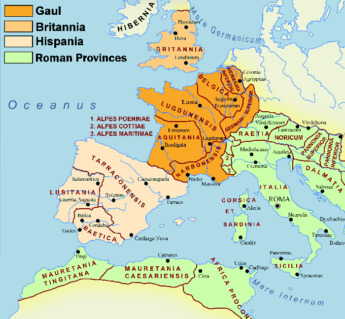
Areas Controlled by the Gallic Empire ▲ |
|---|
| | |
|---|
The Later Emperors ▲ |
|---|
|
After Postumus the Gallic Empire contracted and destabilised. His immediate successor Marius — reportedly a man of humble origins who had risen through the army, possibly from a background as an armourer or blacksmith — lasted only a matter of weeks before he too was killed. The brevity of his reign is a vivid illustration of how completely the breakaway state depended on personal loyalty rather than institutional structures. When the man at the top changed, everything was up for renegotiation.
Victorinus followed, and held the empire together for roughly a year and a half, but lost Hispania in the process — the Spanish provinces, never as firmly attached to the Gallic project as Gaul and Britain, drifted back toward the central empire after Postumus's death. By the time Tetricus I took power in 270 AD the Gallic Empire had been reduced to Gaul and Britannia.
Tetricus is an interesting figure. He was a civilian administrator rather than a military man, which put him at a disadvantage in a state that ultimately rested on the loyalty of the Rhine legions. There is a persistent ancient tradition that he secretly invited Aurelian to invade, hoping that defeat would provide him with a respectable exit from a position he could no longer hold. Whether or not that is true, the outcome was the Battle of Châlons in 274 AD — and the end of the Gallic Empire.
| | |
|---|
Britain during the Gallic Empire ▲ |
|---|
|
Britain was part of the Gallic Empire for its entire fourteen-year existence, and this is the aspect of the period most directly relevant to the rest of this site. What did that mean in practice?
The Classis Britannica — the Channel Fleet — continued to operate throughout this period, almost certainly under Gallic Empire authority rather than that of the central empire. The Wealden iron bloomeries, which the fleet administered and supplied, were at or near peak production during the third century. The network of ironworks in the Brede valley, the Rother valley, and around what is now Battle was producing hundreds of tons of iron per year, shipped across the Channel under fleet supervision. For the detail of that industrial operation see the Wealden Ironworking page.
In other words, for fourteen years the entire military-industrial complex of south-east Britain — the fleet, the ironworks, the oak shipyards, the coastal forts — operated independently of Rome under a breakaway western emperor. When Aurelian reabsorbed the Gallic Empire in 274, he recovered the territory but he did not dismantle that infrastructure. It remained in place, under the same command structures, ready for the next man who understood what it was worth.
That man was Carausius. He arrived as fleet commander in 285, just eleven years after the Gallic Empire ended. He had grown up watching it function. He understood, better than most, that the Channel and the Weald together constituted a self-contained strategic resource that could sustain an independent empire — provided the man controlling it also controlled the fleet. See the Carausius and Pevensey page for the full argument.
| | |
|---|
The Battle of Châlons 274 AD ▲ |
|---|
|
The Battle of Châlons — fought near modern Châlons-en-Champagne in the Marne, well inside Gaul — was the decisive engagement that ended the breakaway state. Aurelian brought a force of approximately 35,000 legionaries, supported by archers, slingers and cavalry. Tetricus commanded a significantly larger force, estimated in the ancient sources at 60,000 to 90,000 men, though ancient figures for losing armies should always be treated with some caution.
The disparity in outcome was not primarily about numbers. Aurelian's troops were field army legionaries — trained for open battle, experienced in offensive warfare, accustomed to fighting as a coordinated force. Tetricus's men were predominantly garrison troops from the Rhine Limes — soldiers whose entire military experience had been defensive, holding a fixed frontier line against raiding parties rather than fighting pitched battles in open country. When Aurelian's veterans engaged them, the difference in capability was decisive. Aurelian lost perhaps 6,000 men. Tetricus lost over 50,000.
The scale of that loss had consequences that extended far beyond the immediate battle.
| | |
|---|
The consequences — a chain that ends at Pevensey ▲ |
|---|
|
The destruction of the Rhine garrison at Châlons left the most strategically important frontier in the western empire dangerously exposed. Fifty thousand garrison troops could not be replaced quickly. The Franks and Alemans, who had been held back by those troops for decades, now found the frontier permeable. Raids deepened into Gaul. Roman administrative control of the lower Rhine weakened. The political instability this created fed directly into the Bagaudae revolt — a large-scale uprising of peasants and dispossessed soldiers in northern Gaul that tied down imperial military resources throughout the late third century.
Maximian, appointed to deal with the western crisis in 285, was fighting the Bagaudae in northern Gaul when he gave Carausius command of the Channel Fleet. He did not have the capacity to deal with both the land frontier and the Channel pirates simultaneously. The appointment that enabled the rebellion was itself a consequence of having insufficient troops — and the troop shortage was a direct consequence of Châlons.
The chain runs as follows:
- Châlons in 274 destroys the Rhine garrison.
- The weakened frontier allows Frank and Alemannic pressure to destabilise Gaul.
- The Bagaudae revolt absorbs Maximian's attention.
- Maximian appoints Carausius to handle the Channel because he has no one else available.
- Carausius uses the appointment to build the fleet, fund the construction at Pevensey, and prepare the rebellion that begins in 286.
The Battle of Châlons, fought twelve years before a single stone was laid at Pevensey, is arguably the first event in the chain that built the fort. Rome's failure to understand the structural vulnerability of the western provinces — that control of the Channel, the fleet, and the Wealden iron was a self-contained engine of independence — meant that it kept producing the conditions for exactly the revolt it feared most.
| | |
|---|
The Palmyrene parallel ▲ |
|---|
|
It is worth noting that the Gallic Empire was not the only breakaway state Aurelian had to defeat. At the same moment, the Palmyrene Empire under the regent Zenobia controlled the eastern provinces — Egypt, Syria, and much of Asia Minor. Aurelian defeated Zenobia in 272 AD and the Gallic Empire in 274 AD, reunifying the empire within two years. It was one of the most remarkable military and political achievements of the century.
But reunification under Aurelian did not resolve the underlying problem. The western provinces still had the legions, the iron, the timber, and the coastline. The institutional weaknesses that had allowed the empire to fracture were patched rather than repaired. Within twelve years of Aurelian's death, Carausius had demonstrated the point again — and this time he built in stone.
| | |
|---|
Recommended Reading ▲ |
|---|
|
|
|
|
;)