| Battle of Hastings 1066AD - F - The Coastline and Landscape |
|---|
|
| Introduction ▲ |
|---|
The Battle of Hastings was not fought where it was fought by accident. The landscape of 1066 made it almost inevitable.
In October 1066 the Hastings peninsula was a very different place from the Sussex coast we know today. High Tide levels approximately 4.5 metres higher than the present turned large areas of low-lying ground into tidal inlets and salt marsh. The Romney Marsh system extended far further inland than it does today, making the eastern approaches to Hastings effectively impassable to an army. To the north and west stretched the great oak forest of Andredsweald — dense, largely trackless, and crossable only on the old Roman roads and Celtic ridgeways that threaded through it.
The result was a peninsula that was almost entirely surrounded by water, marsh and forest. For William, newly landed with his fleet at anchor in the bay, this was close to an ideal defensive position — his flanks and his ships were protected, and his enemy had only one realistic approach route. For Harold, marching south from London with the Saxon army, the landscape offered no flexibility. He had to come straight down the ridge road and meet William on ground that William had chosen.
This page maps shows a different landscape in 1066AD than today — the sea inlets, the forest boundary, the eroded coastline, the Roman roads and the ridgeways — and explains how each element shaped the strategic situation before the battle began. The landscape did not just provide a backdrop to the Battle of Hastings. It determined the outcome before a sword was drawn.
| The Coastline and Landscape ▲ |
|---|
I will try to explain the landscape of 1066AD from other research I have done, you may disagree with my conclusions, but please read and see if I can convince you.
| 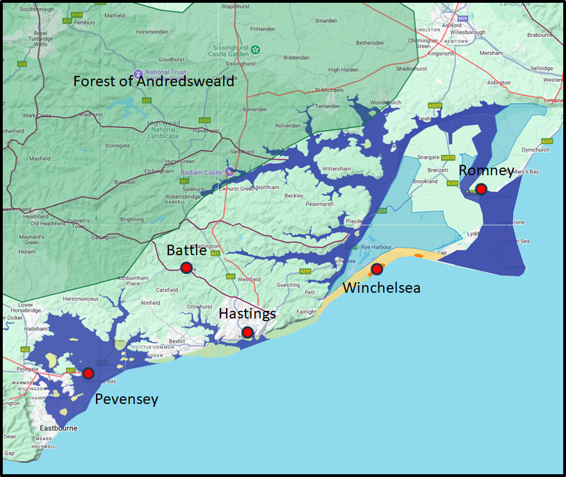
This map is the end result of my current investigations into the landscape in 1066AD.
A quick overview, it would seem that the sea/high tide level was about 4.5 metres higher than the current level, this is shown on the map in dark blue.
Please click on the following link to understand my logic for the sea/high tide levels being higher than today, by using the Saxon island name snippet aeg.
~~Sea_levels_and_the_Pevensey_islands~~ and also ~~Sea_Level_Rises~~.
There was also the Forest of Andredsweald which appears to be identifiable using the location name snippet of hurst and the Domesday locations which can be seen on ~~The_great_oak_forest_of_Andredsweald~~.
The green areas in the sea are representations of the amount of land that has eroded since 1066AD, and the orange area shows the shingle banks, with the yellow areas showing the islands of Old Winchelsea and Broomhill.
~~the_coast_of_East_Sussex_and_erosion~~ and ~~1066AD_Haestingaport~~
The changes in the Romney Marsh are implied with salt marsh shown in pale blue, if you wish to see more details please click the following link ~~Romney_Marsh_History~~.
The forts shown are the Old Roman Fort of Anderida at Pevensey, and our understanding of the Saxon Burh at Hastings ~~Location_of_the_Burh_at_Hastings~~.
And finally the old Roman Roads(Ivan D Margary) are shown in red, and the old Celtic Ridgeways(Ivan D Margary) are shown in Maroon All Margary Roads.
| Other Potential Factors ▲ |
|---|
Senlac hill is mentioned in only one of the Chronicles from the time, the 'Gesta Normannorum Ducum' written by Orderic Vitalis and does 'Senlac' really mean 'Blood Lake' or 'Sand Lake' is there another explanation.
Battle of Hastings 1066AD Location - 3 Senlac where is it and what does it mean ?
Hecheland again only mentioned in one of the Chronicles, this time the 'Chronicles of Battle Abbey', the single line of text could be interpreted as being the Battlefield, or prior to the Battle in 1066.
Battle of Hastings 1066AD Location - 2 Hecheland where is it and what does it mean ?
The Hoar Apple tree again only mentioned in one of the six copies of the Anglo Saxon Chronicles as the Saxon mustering point before the battle, but was it Appledore ?
Battle of Hastings 1066AD - R - The Hoar Apple Tree
The Saxon Shield Wall this is a much acclaimed defensive Saxon formation, but was this really true or is this just a figment of a Victorian scholars imagination.
Battle of Hastings 1066AD Observations - 1 Saxon Shield Wall - did it really exist?
The Malfosse named by the monks at Battle Abbey, but if it were just a story made up by the monks how is it that at least four other chronicles mention a fosse ?
Battle of Hastings 1066AD - U - Evidence for the Battlefield Malfosse
Yes the Normans sailed across the Channel, but can we identify their route, and is their route effected by the landscape, I would like to think so.
Battle of Hastings 1066AD - E - The Sailing - St Valerie to Pevensey
Williams Ship List does this list represent the size of the Norman Fleet ?
Battle of Hastings 1066AD - B - The Ship list of William the Conqueror
Romney why did William destroy the town after the 'Battle of Hastings' ?
Battle of Hastings 1066AD - G - New Romney Destroyed
| | |
|---|
Conclusion ▲ |
|---|
The landscape map on this page, when read together, tells a surprisingly coherent strategic story.
The Hastings peninsula in 1066 was almost entirely surrounded by water and marsh. To the south, the sea. To the east, the tidal inlets and salt marshes of the Romney Marsh system, which in 1066 extended much further inland than today due to sea levels approximately 4.5 metres higher than the present. To the north and west, the dense oak forest of Andredsweald — a largely impenetrable barrier that ran across the whole of the Sussex Weald and which could only be crossed on the old Roman roads and Celtic ridgeways.
This means that any English army coming to confront William had essentially one viable approach route — south along the ridge road from London through the forest, funnelling onto the high ground above Hastings. Harold could not outflank William to the east through the marsh, and could not move cavalry freely through the forest. He had to come straight down the ridge. William, who had cavalry and knew the ground from his fleet's arrival, could choose his defensive position on that ridge and wait.
Far from being a strange place to invade with cavalry, the Hastings peninsula was in many respects an ideal bridgehead. The sea and marsh protected William's flanks and his fleet. The forest constrained Harold's options. And the Roman road network, visible on the map in red, gave William's forces the only practical routes inland if he chose to advance — or gave him advance warning of Harold's approach if he chose to hold.
The landscape did not just provide the backdrop to the Battle of Hastings. It dictated the shape of the battle before a single sword was drawn.
For a more detailed discussion of why William chose Hastings specifically, please see Page Battle of Hastings 1066AD - H - Why Hastings?
|
|
|
|
;)
)


