| The Island of Lime Trees: A New Reading of Lindsey |
|---|
| The Kingdom and Its Geography ▲ |
|---|
|
The Kingdom of Lindsey was one of the lesser Anglo-Saxon kingdoms of early medieval England, absorbing into Northumbria in the seventh century before passing repeatedly between Mercian and Northumbrian control. Its boundaries were defined with unusual precision by the natural landscape: the Humber estuary to the north, the North Sea to the east, the River Witham to the south, and the River Trent to the west, with the Foss Dyke canal connecting Witham and Trent between them. Even in its medieval form scholars noted its distinctive character — one reference work describes the name as reflecting a territory "surrounded by sea, marshes, and fens." This was not metaphor. It was geography. The kingdom also incorporated the Isle of Axholme, a tract of raised ground to the northwest that was itself a genuine island within the surrounding fenland, surrounded by the Trent, Don, Torne and Idle rivers, and only drained and reclaimed in the seventeenth century under the Dutch engineer Cornelius Vermuyden. The inclusion of one island within another hints at a landscape in which elevated dry ground was the exception rather than the rule.
| | |
|---|
The Flooding Hypothesis ▲ |
|---|
|
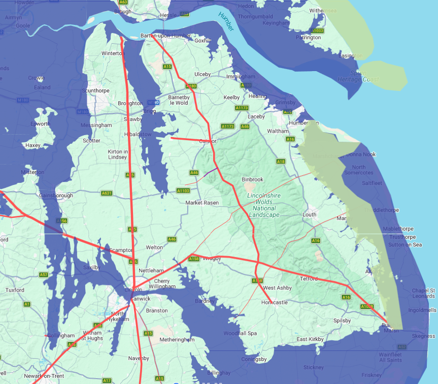
What has not previously been modelled in any systematic way is the effect of higher water levels on the territory as a whole. At 4.5 metres above current high tide, the terrain data for Lincolnshire produces a striking result: the entire region becomes a genuine island. The Humber and the Wash effectively merge into a continuous body of water to north and south. The fenland that even today sits at or below sea level to the south and east becomes fully inundated. Most significantly, the Trent valley to the west floods to a width that would make crossing it a serious military and logistical undertaking rather than a simple river ford. What remains above the waterline is a substantial but clearly bounded island of higher ground, with the limestone ridge of what would become the Lincolnshire Wolds forming its elevated spine. This is not a minor adjustment to the landscape. It is a fundamentally different geography, one in which the kingdom of Lindsey was not merely described as island-like but was, in the most literal sense, an island.
| | |
|---|
The Roman Evidence ▲ |
|---|
|
The Romans understood this territory in exactly those terms, and their road network reflects it. Roman roads do not meander. They connect strategic nodes — river crossings, supply depots, defensible high ground, administrative centres — and they do so with engineering precision. The network in this area resolves to exactly two crossing points onto the island. The first is Lincoln itself, where Ermine Street crosses from the south and connects to the wider road system. The second is Littleborough, known to the Romans as Segelocum, where the road connecting Lincoln and Doncaster crossed the Trent. At Segelocum the Romans constructed a substantial causeway across the river, 5.5 metres wide, supported by oak piles driven into the riverbed and surfaced with large stone slabs. On the eastern bank of the Trent at Marton, a Roman fort was built specifically to guard this crossing — described by Historic England as controlling the first crossing point of the Trent south of its outfall into the Humber. Segelocum itself grew into a significant settlement, estimated at around 40 acres, appearing twice in the second-century Antonine Itinerary and linked by milestone to Lincoln, 14 Roman miles away. Crucially, the road leaving Lincoln towards Littleborough was routed carefully to avoid low-lying wet ground, suggesting the Romans were acutely aware of the waterlogged terrain on either side of the island's western approach. This was not a coincidental configuration of roads. It was the infrastructure of an island territory, with two controlled and fortified entry points and carefully managed approaches through difficult ground.
| | |
|---|
Map representation of Lindsey with the high tide raised ▲ |
|---|
| | |
|---|
The Domesday Settlement Pattern ▲ |
|---|
|
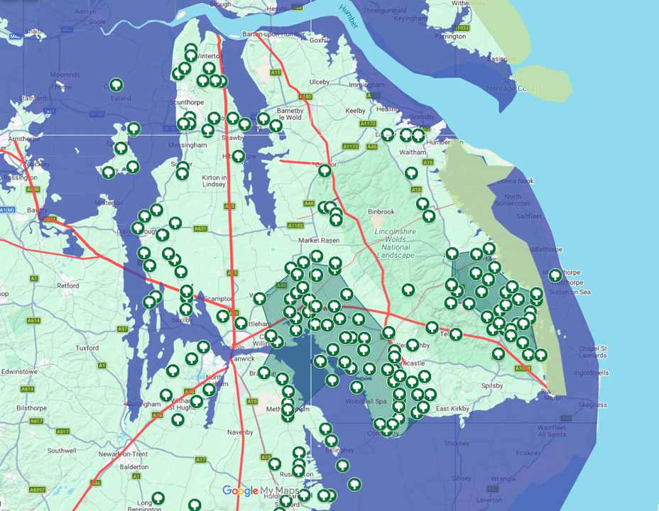
Further confirmation of the flooding model comes from the Domesday survey of 1086. If the territory of Lindsey was genuinely low-lying and waterlogged across much of its western and southern margins, we would expect the pattern of medieval settlement to reflect that — with villages clustering on higher ground and avoiding the flooded zones except where local elevation provided a dry foothold. This is precisely what the Domesday evidence shows.
The overwhelming majority of settlements recorded in the survey sit above the 4.5 metre contour, on the limestone ridge, the Wold slopes, and the higher interior of the island. Where villages do appear within the flooded zone, they are not randomly distributed. They occupy small islands of slightly elevated ground — local rises above the surrounding wetland — in exactly the pattern you would expect from a population navigating a partially inundated landscape.
This mirrors what is known of the Isle of Axholme to the northwest, where each village sat on its own modest rise above the surrounding marsh, and which remained a genuine island until Vermuyden's drainage works in the seventeenth century. The Domesday settlement map does not show a uniform agricultural landscape. It shows a population hugging dry ground, clustering on the island's backbone, and venturing into the lower margins only where the terrain permitted. This is not the pattern of a landscape that had always been freely accessible. It is the fossil imprint of a flooded world.
| | |
|---|
The Name ▲ |
|---|
|
The standard etymology of Lindsey derives the first element from the Celtic Lindum, meaning pool or lake, referring to the settlement that became Roman Lincoln, and interprets the suffix -ēg as meaning island. On this reading, Lindsey means something like the island of Lindum or simply the island of Lincoln. This is the explanation favoured by most modern scholars. But Old English possessed another word, lind, meaning lime or linden tree — the same root that gives us the German Linde and survives in English place names across the country. The Old English suffix -ēg meaning island is identical in both readings.
A second interpretation — the island of lime trees — is phonetically indistinguishable from the standard one and would have been entirely natural to Anglo-Saxon speakers who encountered this landscape. The two etymologies are not necessarily in competition. Place names frequently carry layered meanings, and a name that sounded like both the island of Lincoln and the island of lime trees may have resonated precisely because both descriptions were accurate. What has been missing, until now, is the physical evidence to make the lime tree reading more than a phonetic curiosity.
| | |
|---|
The Lime Trees ▲ |
|---|
 That evidence exists, and it is substantial. Lincolnshire contains Britain's largest surviving concentration of ancient small-leaved lime woodland, the species known in Old English as lind. This is not a medieval or post-medieval planting. The woodland has been dated to over five thousand years of continuous presence, predating the Anglo-Saxon naming of the kingdom by millennia. The Domesday survey of 1086, taken at a point when the name Lindsey was still in active use, records woodland distributed across the interior of the island territory — not on the exposed tops of the Wolds, which would have been open windswept chalk upland unsuitable for lime, but on the sheltered slopes and lower ground below them.
This is precisely where small-leaved lime grows naturally. It is a woodland species of valley sides, sheltered plateau edges and well-drained lower slopes, not a hilltop tree. Someone crossing the flooded Trent valley and approaching the island from the west would not have seen bare summits. They would have seen wooded slopes rising from the water — a lime-covered island presenting itself exactly as the name describes.
The limewoods are centred on the Bardney area just east of Lincoln, extending across the higher ground that on the flooding model forms the heart of the island. If a place name such as Limewold exists within the county, meaning lime tree hills or lime tree forest, it would add a further layer of direct testimony. The lime trees were there, on the island, in sufficient density and antiquity to define the landscape for any observer arriving for the first time.
Please click on the map for a more detailed version
| | |
|---|
Conclusion ▲ |
|---|
|
The "island of lime trees" reading of Lindsey has been noted by scholars and set aside, on the reasonable grounds that the Celtic Lindum etymology for Lincoln is well-established and the lime tree connection appeared coincidental. What changes this assessment is the flooding map. If the territory of Lindsey was, at the time of its naming, genuinely an island — bounded by water on all sides, with only two fortified Roman crossings connecting it to the wider landscape — then the choice of -ēg, meaning island, becomes not a metaphor but a statement of fact. And if that island was characterised by the extensive ancient lime woodland that demonstrably existed on its higher ground, then lind-ēg, the island of lime trees, was not a poetic gloss on an obscure Celtic river name. It was a description of what people saw when they arrived. The physical geography, the Roman road network, the botanical record, and the etymology all point in the same direction..
|
|
|
;)
)


