| Anglo Saxon Chronicles - 477AD - Cymensora
(Ælle,Cymen, Wlenca and Cissa ) |
|---|
| The entry from the Chronicles |
|---|
Original text
Her cuom Ælle on Bretenlond ⁊ his .iii. suna, Cymen ⁊ Wlenca ⁊ Cissa, mid .iii. scipum on þa stowe þe is nemned Cymenesora, ⁊ þær ofslogon monige Wealas ⁊ sume on fleame bedrifon on þone wudu þe is genemned Andredesleage.
Translation
477AD. In 477AD Aelle came to Britain with his three sons Cymen, Wlenca and Cissa with three ships landing at the place called Cymensora. There he killed many Welsh and drove some in flight into the forest of Andredsweald.
| Name Derivation |
|---|
|
Cymensora has never been officially identified, but the place name itself provides a logical trail. Cymensora means 'Cymen's shore' — the landing beach of Cymen, one of Ælle's sons. A settlement established at that landing point would naturally acquire the suffix ham (a settlement in a valley, or with a landing stage), giving Cymensora ham. Over time, with the original meaning of ora forgotten, the name would be shortened by dropping the leader's name from the front — a common process in Saxon place name evolution — leaving Soraham, then Shoreham.
The modern town of Shoreham-by-Sea sits at the mouth of the River Adur — a sheltered valley estuary that would have provided exactly the kind of low-shore landing beach the Saxon word ora describes, and well away from the major Roman centres at Pevensey and Chichester that Ælle would have wished to avoid on first landing.
Across the River Adur from Shoreham lies Lancing, which appears to derive from Wlenca ing — the fort of Wlenca, one of Ælle's sons. This strongly supports the Shoreham identification: Ælle lands at Cymensora on the west bank of the Adur, and Wlenca establishes a fort on the east bank to secure the river crossing and control access from the sea. The two place names, facing each other across the estuary, corroborate each other directly.
| | |
|---|
Conclusion |
|---|
|
Shoreham is the most geographically coherent identification for Cymensora. It sits at the midpoint of the Sussex coast between the Haestingas territory to the east and Port's later landing at Portsmouth to the west, it provides a sheltered valley estuary for landing, it lies away from established Roman centres, and it offers a clear escape route north into the Weald along former Roman roads — exactly the path the retreating Welsh would have needed.
The Lancing evidence tips the balance further. Two sons of Ælle, two place names, two sides of the same river mouth: the odds of that being coincidental are low. If Shoreham is correct, then one of the most debated unidentified locations in the Anglo Saxon Chronicles has been sitting in plain sight for over a thousand years, its name quietly preserving the memory of the landing that began the Saxon conquest of Sussex.
| | |
|---|
Map showing the Battles of Aelle, Cymen, Wlencing & Cissa |
|---|
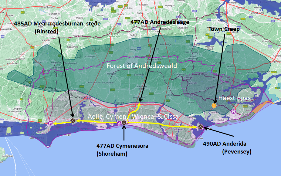
Map generated using Google My Maps 2024 - showing the Landscape, modern Counties and sea in 477AD
Please Note: this map is my interpretation of the Anglo Saxon Chronicles entries relating to Aelle, Cymen, Wlencing & Cissa and their take over of Sussex, the thin purple line shows the modern Sussex boundary.
Aelle controlled West Sussex up to Andredsweald, and the Haestingas controlled East Sussex both of these areas are shaded in light purple.
The logic for the coastal changes and the Forest of Andredsweald can be viewed on the following pages:
Roman Roads in Britain
Anglo Saxon Chronicles - 892AD - The Great Oak Forest of Andredsweald
The Variable Ocean: Was the high tide level in Saxon times at Pevensey at about 4.5 metres ?
The Variable Ocean: Was the high tide level in Saxon times in the Wash 4 to 5 metres higher ?
Landscape - The History of the Romney Marsh in maps
The Variable Ocean: Roman Locations that have not been identified and roads that just terminate
|
|
|
;)


