| Invaders 3 - Aelle Cymen Wlenca Cissa - conquest of West Sussex |
|---|
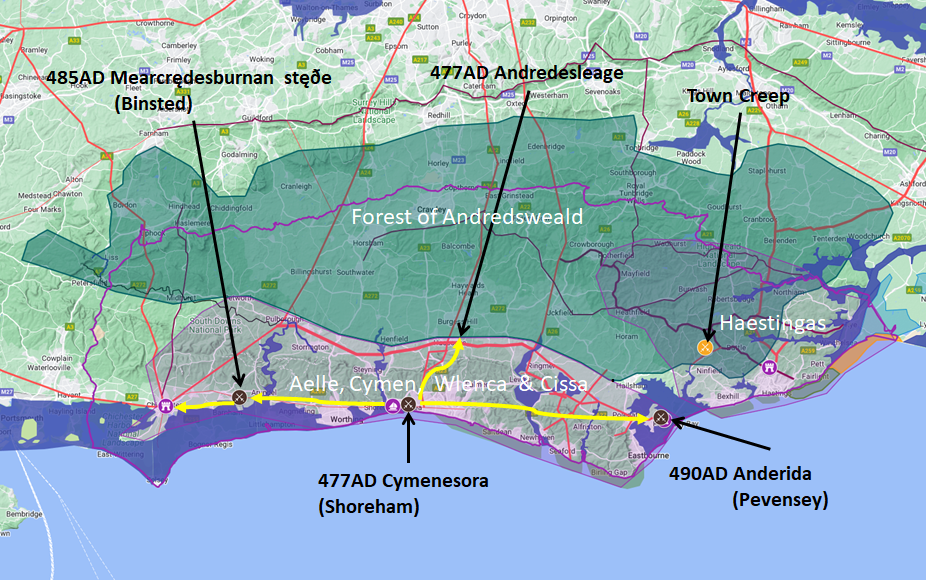
Ælle, Cymen, Wlenca and Cissa land at Cymensora which means Cymens Shore and settle there on the valley floor in a hamm, so the place becomes Cymens ora hamm which over time reduces to Shoreham. They defeat the Welsh on landing who flee along the old roman road from Portslade to Hurstpierpoint and then continue their flight into Andredsweald on the same Roman road.
Anglo Saxon Chronicles - 477AD - Cymensora (Ælle,Cymen, Wlenca and Cissa )
The Saxons then appear to head westward, most probably to take Chichester, but have a battle at Mearcrædesburnan stæðe which is most likely Binsted in West Sussex, and then take Chichester.
Anglo Saxon Chronicles - 485AD - Mearcrædesburnan stæðe (Ælle,Cymen, Wlenca and Cissa )
Now they hold the old Roman fort in Chichester to the West they head eastwards to take the remaining land and Roman fortress in Pevensey, where they slaughter all the inhabitants.
Anglo Saxon Chronicles - 491AD - Andredescester (Ælle,Cymen, Wlenca and Cissa)
At this point there are no more references to eastward expansion, so it is logical to assume they had reached the borders of the Haestingas, who were another Saxon tribe and who must have landed prior to 477AD, but most likely after about 449AD when it was reported that 'Henghest and Horsa then sent to the Angles, and desired them to send more assistance. They described the worthlessness of the Britons, and the richness of the land. Then came the men from three powers of Germany; the Old Saxons, the Angles, and the Jutes.'
The only other reference to Ælle in the Chronicles is:
560AD This year Ceawlin undertook the government of the West-Saxons; and Ælle, on the death of Ida, that of the Northumbrians; each of whom reigned thirty winters.
588AD This year died King Ælle ; and Ethelric reigned after him five years.
There are no other references to Ælle, Cymen, Wlenca or Cissa after 588AD.
| Map showing the Battles of Ælle, Cymen, Wlenca and Cissa |
|---|
Map generated using Google My Maps 2024 - showing the Landscape, modern Counties and sea in 455AD
Please Note: this map is my interpretation of the Anglo Saxon Chronicles entries relating to Ælle, Cymen, Wlenca and Cissa and their take over of Sussex, the thick purple line shows the modern Sussex boundary. The kingdom of the Suth Saxons and that of the Haestingas are shaded in purple, the great Forest of Andredsweald is shaded in green.
The logic for the coastal changes and the Forest of Andredsweald can be viewed on the following pages:
Roman Roads in Britain
Anglo Saxon Chronicles - 892AD - The Great Oak Forest of Andredsweald
Landscape - Was the high tide level in Saxon times at Pevensey at about 4.5 metres ?
Landscape - Was the high tide level in Saxon times in the Wash 4 to 5 metres higher ?
Landscape - The History of the Romney Marsh in maps
Roman Locations that have not been identified and roads that just terminate
| | |
|---|
Conclusion |
|---|
The above timeline is valid according to the Anglo Saxon Chronicles, however the description of the events is my interpretation of the Chronicles, please read the individual links to see if you agree with this.
|
|
|
;)


