| Anglo Saxon Chronicles - 449AD(2) - Welsh Flee
(Henghest and Horsa) |
|---|
| The entry from the Chronicles |
|---|
Original text
Se cing het hi feohtan agien Pihtas, ⁊ hi swa dydan ⁊ sige hæfdan swa hwar swa hi comon.
Translation
449AD. The king directed them(Henghest and Horsa) to fight against the Picts; and they did so; and obtained the victory wheresoever they came.
| What does this mean |
|---|
This looks like Vortigern may have been pushed back to Richborough and his new Jutish mercenaries have helped him push Marcian and Valentinian back out of Canterbury, and Vortigern can then retake control of Kent.
Canterbury was on a strategic crossing point of the Stour along Watling Street, and was the Cantii's primary town, so was important for Henghest and Horsa to control.
Sometime between 449AD and 455AD it would seem that Henghest and Horsa rebelled against Vortigern and took over Canterbury, with Vortigern retreating to the other capital of the Cantii which was at Rochester.
| Possible interpretation of the Chronicles |
|---|
If Vortigern had been pushed back to Richborough by Marcian and Valentinian then Ebbsfleet would also have been a good point for the Jutes to land as it would provide a blockade of the Wantsum Channel, give them a defensive fort, and a route to Richborough, Canterbury and along the coast.
Henghest and Horsa's base at Ebbsfleet, would have enabled them to sail into Canterbury, Rochester, Crayford and Purfleet, and that may have been the route taken as opposed to the yellow lines on the map below that follow Watling Street.
| Map showing the Battles of Henghest and Horsa |
|---|
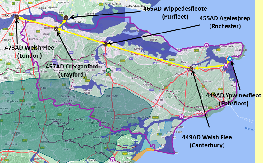
Map generated using Google My Maps 2024 - showing the Landscape, modern Counties and sea in 455AD
Please Note: this map is my interpretation of the Anglo Saxon Chronicles entries relating to Henghest, Horsa and Aesc and their take over of Kent, the purple line shows the modern Kent boundary.
The logic for the coastal changes and the Forest of Andredsweald can be viewed on the following pages:
Roman Roads in Britain
Landscape - The Great Oak Forest of Andredsweald
Landscape - Was the high tide level in Saxon times at Pevensey at about 4.5 metres ?
Landscape - Was the high tide level in Saxon times in the Wash 4 to 5 metres higher ?
Landscape - The History of the Romney Marsh in maps
Roman Locations that have not been identified and roads that just terminate
|
|
|
;)