|

Saxon thegn | Anglo Saxon History |  | |
| Anglo Saxon Chronicles - 485AD - Mearcrædesburnan stæðe
(Ælle,Cymen, Wlenca and Cissa ) |
|---|
| | The entry from the Chronicles |
|---|
Original text
Her Ælle gefeaht wiþ Walas neah Mearcrædesburnan stæðe.
Translation
485AD. This year Ælle defeated the Welsh near Mearcrædesburnan stæðe.
| | Where might it be |
|---|
Mearcrædesburnan stæðe is made up of four snippets, Mear the sea, burnan a stream and
stæðe - staith a landing point, There is no Saxon word crædes, but could have been a phonetic spelling
of cræð which would be pronounced creth with the nearest word being cærse/cresse meaning watercress.
Hence the translation for the place is the ‘sea landing place on the watercress stream’. If this is the case
then the original spelling should be Mearcærsesburnan stæðe, or if it were phonetic spelling then
Mearcræðesburnan stæðe.
So we are looking along the South coast for a stream that flows into the sea where watercress can be grown. Watercress
only grows in very clean streams found in chalk areas, traditionally the main watercress growing area in the UK is in
Hampshire or West Sussex.
So can we make anything out from the name, could it have been shortened perhaps to burnan staith. Locations originally
stæðe (staith) have transformed over time to stead, sted, staith and stede, so this could now be burnan sted, and then
shortened again to burnsted, bunstead or binsted. There is a place called Binsted in West Sussex which is on a
chalk stream and would have been on the coast in Saxon times.
It also has an ancient earthworks running North to South known as the War Dyke probably build to protect Chichester,
which Aelle would have had to pass to get to Chichester. We know Chichester is in Sussex, so its likely that for Aelle
to captured the town he would have to pass through Binsted as it was on the old Roman main coast road from Arundel to
Chichester. Benestede is recorded in the Domesday book so is an old place.
| | Possible interpretation of the Chronicles |
|---|
Mearcrædesburnan stæðe is most likely at Binsted, where there is an ancient earthworks that
probably was designed to defend Chichester, once these troop had been defeated then Chichester would have been open to
the Saxons, and they would easily have taken the city.
It would seem likely that Ælle taking Chichester would have been an important story for the old Chroniclers, however no
evidence of this has been found, hence a battle at Binsted which could have been the outer boundary of Chichester would
have been important enough to be recorded.
This area was the ancestral home of the Regnensis who had their capital at Chichester(Noviomagus Reginorum) so once this
was taken by Aelle, he had control of the area.
A great deal of conjecture by historians has said that a possible location for this battle was at Town Creep near modern
Battle, but this area would have been occupied by the Haestingas and as they appear to be Saxon and friendly with the
Suth Saxons this would seem very unlikely.
Another factor that makes this less likely is that this battle took place 5 years before Anderida was taken, and as
Battle is further East of Anderida and only about 10 miles away, you would have expected the Saxons to have taken
Anderida before Mearcrædesburnan stæðe, if it were located here.
|
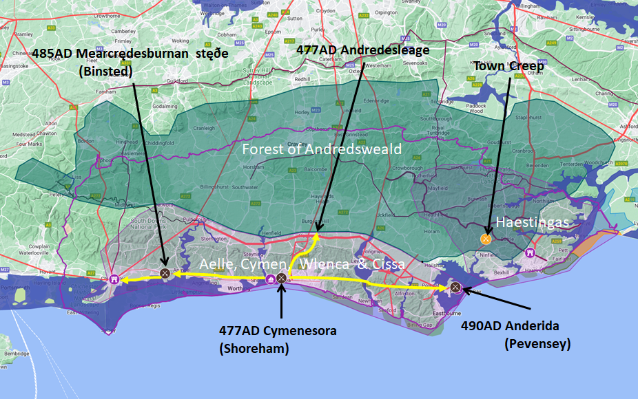
Map showing the Battles of Aelle, Cymen, Wlencing & Cissa
|
|---|

Map generated using Google My Maps 2024 - showing the
Landscape, modern Counties and sea in 477AD
Please Note: this map is my interpretation of the Anglo Saxon Chronicles entries relating to Aelle, Cymen, Wlencing &
Cissa and their take over of Sussex, the thin purple line shows the modern Sussex boundary.
Aelle controlled West Sussex up to Andredsweald, and the Haestingas controlled East Sussex both of these areas are
shaded in light purple.
The logic for the coastal changes and the Forest of Andredsweald can be viewed on the following pages:
Roman Roads in
Britain
The Great
Forest of Andredsweald - Anglo Saxon Chronicles
Landscape
- Was the sea level in Saxon times at Pevensey 4 to 5 metres higher ?
Was the high
tide in Saxon times 5 metres higher ? - the Wash
Landscape - The History
of the Romney Marsh in maps
Roman Locations that have
not been identified and roads that just terminate
|
|
|
|
|
| |
|
|
Local Interest
Just click an image |
|
|
|
|
|
|
|
|
|
|
|
|
| |
|
|