| Anglo Saxon Chronicles - 501AD - Portsmouth
(Port, Beda and Mela) |
|---|
| The entry from the Chronicles |
|---|
Original text
Her cuom Port on Bretene ⁊ his .ii. suna Bieda ⁊ Mægla mid .ii. scipum on þære stowe þe is gecueden Portesmuþa ⁊ ofslogon anne giongne brettiscmonnan, swiþe æþelne monnan.
Translation
501AD. This year Port and his two sons, Beda and Mela, came into Britain, with two ships, at a place called Portesmuþa. They soon landed, and slew on the spot a young Briton of very high rank.
| Where might it be |
|---|
Portesmuþa, this name is made up of two Saxon snippets 'Port' named after 'Port' and 'muþa' pronounced muther which means 'mouth' hence they landed in 'Portsmouth'.
The Chronicles description of Portsmouth appears to mean the area around , and due to the names in the area, he is most likely to have initially landed and occupied 'Portsea' as this means 'Port's island' in Saxon with this location making strategic sense. This would have allowed Port to blockade, attack and then occupy Portchester, and also possibly explain the killing of the young Briton who was probably defending the fort, or maybe just the island.
Portchester, is also most likely named after him as 'Port' and 'Chester' meaning an 'old Roman Fort' hence 'Port's Roman Fort'.
| 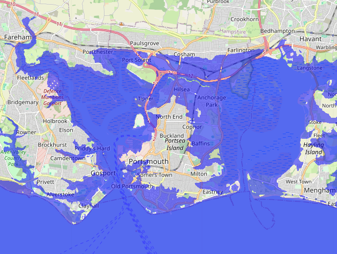
Map is taken from https://www.floodmap.net/ with the high tide level set at 4 metres, please click the map to be taken to their site.
| | |
|---|
Map showing the Battles of Cerdic, Cynric and the West Saxons |
|---|
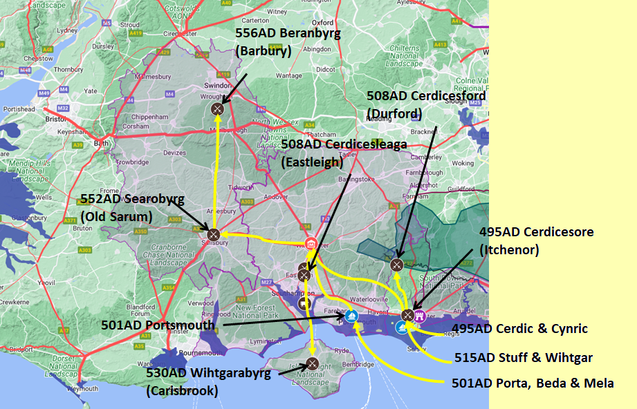
Map generated using Google My Maps 2024 - showing the Landscape, modern Counties and sea in 477AD
Please Note: this map is my interpretation of the Anglo Saxon Chronicles entries relating to Cerdic, Cynric and the West Saxons and their take over of Hampshire, the thin purple line shows the modern Hampshire boundary.
The logic for the coastal changes and the Forest of Andredsweald can be viewed on the following pages:
Roman Roads in Britain
Anglo Saxon Chronicles - 892AD - The Great Oak Forest of Andredsweald
Landscape - Was the high tide level in Saxon times at Pevensey at about 4.5 metres ?
Landscape - Was the high tide level in Saxon times in the Wash 4 to 5 metres higher ?
Landscape - The History of the Romney Marsh in maps
Roman Locations that have not been identified and roads that just terminate
| | |
|---|
Possible interpretation of the Chronicles |
|---|
My interpretation of this entry is that Port landed at Portsea in the area of Portsmouth, and then killed the young Briton defending Portchester which would mean he then had control of the whole protected harbour and surrounding land. If he had landed at Portsea he would then have been able to block any shipping trying to reach Portchester, and prevent supplies arriving.
With Henghest, the Haestingas, Aelle and Cerdic controlling the coast to the east, the Saxons and Jutes would then control the coast all the way from North Kent to Portsmouth.
|
|
|
;)


