|
 | Anglo Saxon History |  | |
| Anglo Saxon Chronicles - 491AD - Andredescester
(Ælle,Cymen, Wlenca and Cissa) |
|---|
| | The entry from the Chronicles |
|---|
Original text
Her Ælle, Cissa ymbsæton Andredescester, ofslogon alle þa þe þærinne eardedon; ne wearþ þær forþon an Bret to lafe.
Translation
491AD. Aelle and Cissa besieged Anderida , near Pevensey, and killed all who were inside, so there was not one Briton left.
| | Further Details |
|---|
Anderida is the Roman name for the Saxon Shore Fort at Pevensey, Andredescester means the fort at the edge of Andredesleage (the forest now know as Andredsweald)
The South Saxons appear to have consolidated their western boundary at Chichester - the old Roman fortified city, and are now working their way back to the East to ensure all 'Welsh' resistance is removed in the area south of Andredsweald.
From the distribution of places containing ing(nering - fortified) it would seem that they had consolidated the Adur valley then followed the old Roman road north of the downs towards the east, pushing the 'Welsh' eastbound and finding resistance near Plumpton and Barcombe/East Malling.
Then marching past Lewes towards Pevensey where they met further resistance at Wilmington, again near Polegate where they trapped the remaining 'Welsh' on the small peninsular of Pevensey, finally attacking the Saxon Shore Fort of Anderida present day Pevensey in which they killed all remaining there.
| | Possible interpretation of the Chronicles |
|---|
Andredescester is made up of two Saxon snippets Andred which refers to the Forest of Andreadsleage and cester which means a large Roman Ford. Cester is the source for towns containing the snippet Caistor, Chester, Caster etc.
The only other mentions of Ælle after this is that he appears to be
Anderida was the Roman name for the massive Roman Saxon Shore Fort on the island of Pevensey.
|
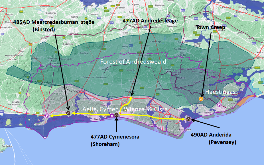
Map showing the Battles of Aelle, Cymen, Wlencing & Cissa
|
|---|

Map generated using Google My Maps 2024 - showing the Landscape, modern Counties and sea in 477AD
Please Note: this map is my interpretation of the Anglo Saxon Chronicles entries relating to Aelle, Cymen, Wlencing & Cissa and their take over of Sussex, the thin purple line shows the modern Sussex boundary.
Aelle controlled West Sussex up to Andredsweald, and the Haestingas controlled East Sussex both of these areas are shaded in light purple.
The logic for the coastal changes and the Forest of Andredsweald can be viewed on the following pages:
Roman Roads in Britain
The Great Forest of Andredsweald - Anglo Saxon Chronicles
Landscape - Was the sea level in Saxon times at Pevensey 4 to 5 metres higher ?
Was the high tide in Saxon times 5 metres higher ? - the Wash
Landscape - The History of the Romney Marsh in maps
Roman Locations that have not been identified and roads that just terminate
|
|
|
|
|
| |
|
|
Local Interest
Just click an image |
|
|
|
|
|
|
|
|
|
|
|
|
| |
|
|