| Anglo Saxon Chronicles - 519AD - Cerdicesford
(Cerdic and Cynric) |
|---|
| The entry from the Chronicles |
|---|
Original text
Her Cerdic ⁊ Cynric Westsexena rice onfengun on þy ilcan geare hie fuhton wiþ Brettas þær mon nu nemneþ Cerdicesford. ⁊ siþþan ricsadan Westsexana cynebearn of þan dæge.
Translation
519AD. This year Cerdic and Cynric undertook the government of the West-Saxons; the same year they fought with the Britons at a place now called Cerdicsford (Shawford). From that day have reigned the children of the West-Saxon kings.
| Where might it be |
|---|
Let us logically look at the landscape as this usually provides clues as to the location of unknown Battle locations.
Firstly the most likely place for a Battle was on an old Roman road at a river crossing, or the main town of a tribe.
Cerdicesford, if this was modern Shawford, would make sense as it would be the last defense point for Winchester on the boundary of Natanleod's kingdom. see Anglo Saxon Chronicles - 508AD - Cerdicesford and Netley (Cerdic and Cynric)
Winchester was the capital of Wessex probably at its foundation, perhaps from 519AD as a defeat for the Britons at Shawford would leave the town open to invasion,, and this might explain the This year Cerdic and Cynric undertook the government of the West-Saxons in the Chronicle.
The most likely place for the original Winchester pre-Roman was the old Celtic hillfort on St Catherines Hill just outside the town, not far from Shawford.
| Possible interpretation of the Chronicles |
|---|
The majority of this article is speculation, but logically it fits together especially in conjunction with the last article for Cerdicesford Anglo Saxon Chronicles - 508AD - Cerdicesford and Netley (Cerdic and Cynric)
Cerdic & Cynric gained control of Wessex, probably after taking Winchester. It would seem likely that Wessex was originally made up from the combined Saxon forces who landed nearby, so this would include Cerdic & Cynric, Port, Beda and Mela and of course Stuff and Whtigar all of whom seem to be related, even if Stuff & Whitgar are Jutes according to the ASC.
This area was the ancestral home of the Belgae and their capital was at Winchester(Venta Belgarum), however it would seem that they had two other centres at Old Sarum and Barbury.
| Map showing the Battles of Cerdic, Cynric and the West Saxons |
|---|
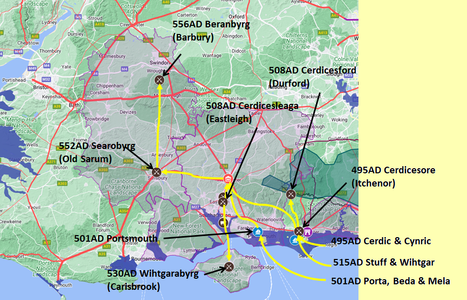
Map generated using Google My Maps 2024 - showing the Landscape, modern Counties and sea in 477AD
Please Note: this map is my interpretation of the Anglo Saxon Chronicles entries relating to Cerdic, Cynric and the West Saxons and their take over of Hampshire, the thin purple line shows the modern Hampshire boundary.
The logic for the coastal changes and the Forest of Andredsweald can be viewed on the following pages:
Roman Roads in Britain
Anglo Saxon Chronicles - 892AD - The Great Oak Forest of Andredsweald
Landscape - Was the high tide level in Saxon times at Pevensey at about 4.5 metres ?
Landscape - Was the high tide level in Saxon times in the Wash 4 to 5 metres higher ?
Landscape - The History of the Romney Marsh in maps
Roman Locations that have not been identified and roads that just terminate
|
|
|
;)


