| Anglo Saxon Chronicles - 457AD - Crecganford
(Henghest and Æsc) |
|---|
| The entry from the Chronicles |
|---|
Original text
Her Hengest ⁊ Æsc fuhton wiþ Brettas in þære stowe þe is gecueden Crecganford ⁊ þær ofslogon .iiiim. wera, ⁊ þa Brettas þa forleton Centlond ⁊ mid micle ege flugon to Lundenbyrg.
Translation
457AD. This year Hengest and Æsc fought with the Britons on the spot that is called Crecganford, and there slew four thousand men. The Britons then forsook the land of Kent, and in great consternation fled to London.
| What does this mean |
|---|
If we look at the Saxon name 'Crecganford', it is made up from two Saxon components 'Crecgan' which means 'Creek' and 'ford' which means 'a river fording point'.
This is most likely at Crayford, with the name translating to 'the ford in the Creek' and is another good defensive point on Watling Street, probably from troops from London, it would seem that after this the whole of Kent was now totally controlled by Henghest and Horsa.
| Possible interpretation of the Chronicles |
|---|
Henghest has now travelled the length of Kent from Ebbsfleet to Crayford and now controls all of Kent, he has lost his brother Horsa at Rochester, but his place has now been taken by Henghest son Æsc.
| Map showing the Battles of Henghest and Horsa |
|---|
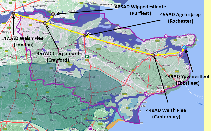
Map generated using Google My Maps 2024 - showing the Landscape, modern Counties and sea in 455AD
Please Note: this map is my interpretation of the Anglo Saxon Chronicles entries relating to Henghest, Horsa and Aesc and their take over of Kent, the purple line shows the modern Kent boundary.
The logic for the coastal changes and the Forest of Andredsweald can be viewed on the following pages:
Roman Roads in Britain
Anglo Saxon Chronicles - 892AD - The Great Oak Forest of Andredsweald
Landscape - Was the high tide level in Saxon times at Pevensey at about 4.5 metres ?
Landscape - Was the high tide level in Saxon times in the Wash 4 to 5 metres higher ?
Landscape - The History of the Romney Marsh in maps
Roman Locations that have not been identified and roads that just terminate
|
|
|
;)


