| Anglo Saxon Chronicles - 508AD - Cerdicesford and Netley
(Cerdic and Cynric) |
|---|
| The entry from the Chronicles |
|---|
Original text
Her Cerdic ⁊ Cynric ofslogon ænne brettisccyning, þam was nama Natanleod, ⁊ .v. þusendu wera mid him. Æfter was þæt lond nemned Natanleaga oþ Cerdicesford.
Translation
508AD. This year Cerdic and Cynric slew a British king, whose name was Natanleod, and five thousand men with him. After this was the land named Netley, from him, as far as Cerdicesford (Shawford).
| Where might it be |
|---|
Let us logically look at the landscape as this usually provides clues as to the location of unknown Battle locations.
Firstly the most likely place for a Battle was on an old Roman road at a river crossing, or the main town of a tribe.
In this case the only thing we have is that Natanleod's land was from Netley to Cerdicesford. Netley can be found between Southampton and Portchester on the coast at the time. The next part of the puzzle is where would you find Cerdicesford, this needs to be on a largish river to the north of Netley and this would give the northern boundary Natanleod's land.
North of here are Chandlers Ford on Monks Brook, Twyford and Shawford both on the river Itchen. Rivers were quite often used as boundaries between tribal areas.
The translation of the three locations may help.
Chandlers Ford was originally known as just 'Ford' and only became Chandlers Ford in the 1600's. Monks Brook is only on a tributary of the Itchen, and also it is not on a road that Cerdic and Cynric might use.
Twyford is made up of two Saxon snippets of 'twy' from 'twi' meaning 'twig' and 'ford' from 'forda' a 'river ford', so this is the 'twig ford', not really helpful.
Shawford again made up from two snippets 'shaw' from 'sceaga' meaning 'strip of wood forming a boundary', this could be a good place for the edge of a kingdom, so it could translate to 'the ford by the boundary wood', and would be a good place for the location of Cerdicesford please see the next article to see my additional logic.
Now where would the Battle have taken place, probably near the Roman road from Chichester to Southampton, it is likely to be West of Portsmouth as Port has already pushed the Welsh out so the most likely place would seem to be near the river Meon.
Wickham would be a good place as it would mean the Saxons would need to cross the river and it would defend the split of the Roman road near modern Wickham Park. 'Wickham' consists of two snippets 'Wick' meaning an old Roman Vicus (town) and 'ham' meaning a 'valley settlement'.
It is possible that this was the Kingdom of the Meonwara but this is conjecture.
| Possible interpretation of the Chronicles |
|---|
The majority of this article is conjecture, but logically it fits together especially in conjunction with the next article on Cerdicesford Anglo Saxon Chronicles - 519AD - Cerdicesford (Cerdic and Cynric)
| Map showing the Battles of Cerdic, Cynric and the West Saxons |
|---|
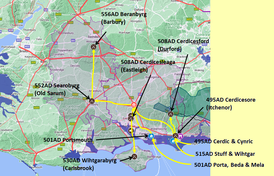
Map generated using Google My Maps 2024 - showing the Landscape, modern Counties and sea in 477AD
Please Note: this map is my interpretation of the Anglo Saxon Chronicles entries relating to Cerdic, Cynric and the West Saxons and their take over of Hampshire, the thin purple line shows the modern Hampshire boundary.
The logic for the coastal changes and the Forest of Andredsweald can be viewed on the following pages:
Roman Roads in Britain
Anglo Saxon Chronicles - 892AD - The Great Oak Forest of Andredsweald
Landscape - Was the high tide level in Saxon times at Pevensey at about 4.5 metres ?
Landscape - Was the high tide level in Saxon times in the Wash 4 to 5 metres higher ?
Landscape - The History of the Romney Marsh in maps
Roman Locations that have not been identified and roads that just terminate
|
|
|
;)


