| Anglo Saxon Chronicles - 465AD - Wippedesfleote
(Henghest and Æsc) |
|---|
| What does this mean |
|---|
If we look at the Saxon name 'Wippedesfleote', it is made up from two Saxon components 'Wippedes' which is named after Wipped, one of Henghest's Thanes and 'fleote' which means a fleet[sea passage between two bodies of land].
This is most likely at Purfleet in Essex, with the name evolving from Wippedesfleote to Wipperfleote, then perfleet and finally Purfleet. It is unusual to have places named after people, as most Saxon place names describe the locations usage. This would mean that Wipped was looked on as being important
| Possible interpretation of the Chronicles |
|---|
This Chronicle reference looks as though the Romano British were trying to attack Kent to force Henghest out, but a large number leaders were killed, which finally stopped any attempts to force Henghest to leave Kent.
| Map showing the Battles of Henghest and Horsa |
|---|
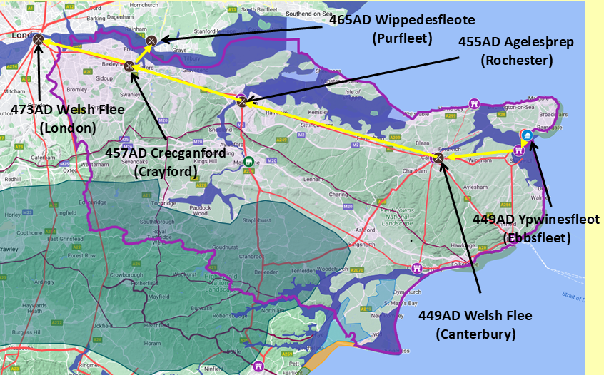
Map generated using Google My Maps 2024 - showing the Landscape, modern Counties and sea in 455AD
Please Note: this map is my interpretation of the Anglo Saxon Chronicles entries relating to Henghest, Horsa and Aesc and their take over of Kent, the purple line shows the modern Kent boundary.
The logic for the coastal changes and the Forest of Andredsweald can be viewed on the following pages:
Roman Roads in Britain
Anglo Saxon Chronicles - 892AD - The Great Oak Forest of Andredsweald
Landscape - Was the high tide level in Saxon times at Pevensey at about 4.5 metres ?
Landscape - Was the high tide level in Saxon times in the Wash 4 to 5 metres higher ?
Landscape - The History of the Romney Marsh in maps
Roman Locations that have not been identified and roads that just terminate
|
|
|
;)


