| Anglo Saxon Chronicles - 530AD - Wihtgarabyrg (Cerdic and Cynric) |
|---|
| The entry from the Chronicles |
|---|
Original text
Her Cerdic ⁊ Cynric genamon Wihte ealond ⁊ ofslogon feala men on Wihtgarabyrg.
Translation
530AD. This year Cerdic and Cynric took the isle of Wight, and slew many men in Wihtgarabyrg.
| Where might it be |
|---|
Wihtgarabyrg is made up of three Saxon snippets 'Wiht' presumably named after Wihtgar or the Island, 'gara' which can means 'a sharp point of land' and 'byrg' a burh a fortress. Hence translating to 'the fort on a sharp point of land on the island of Wight'.
The current mainstream thought of the location of Wihtgarabyrg is Carisbrook, which doesn't really match up with the description.
| My theory as to the location of Whitgarabyrg |
|---|
If the high tide level was 4.5 metres higher as it would seem in early Saxon times, then the Bembridge area would have been a small island. Stuff And Whitgar would seem to have landed at Ethel point as the name Ethel could derive from 'hyd el' pronounced 'hythel' which over time becomes Ethel which can be translated as the people of the 'Important landing place'.
It would seem that Stuff and Whitgar couldn't defeat the other locals for the next 15 years, presumably because they didn't have enough warriors.
Cerdic and Cynric have now joined up with Port and Beda and suppressed the other tribes from Chichester to Winchester and have now stabilised the boundary of their Kingdom, so now can help Stuff and Whitgar, and as they now control a larger area and hence a higher population they now have more warriors.
It would seem likely that they landed at Ryde which could be derived from 'óðer hyð' meaning the 'other important landing place'.
This area was surrounded by the sea from Wooton Creek to Monktonmead brook, and was possibly another island as the area is known as Ashey(the ash island), the fort was on a sharp point of land and most forts were on the top of a hill, therefore we are looking for a name snippet that implies a fort such as down(celtic hillfort), Burgh or Caistor(roman castles) or possibly camp(usually used to describe a Roman camp) .
There is only one name that appears to fit all the descriptions which is Kemphill farm, which is the highest location in the area and which can translate to 'Camp Hyll' meaning the hill with the camp on top.
Taking this area would then allow Cerdic and Cynric to take the St Helens area and join up with Stuff and Whitgar and then take over the island.
| | |
|---|
Possible interpretation of the Chronicles |
|---|
Cerdic & Cynric invaded the Isle of Wight after gaining control of Wessex, probably after taking Winchester. It would seem likely that Wessex was originally made up from the combined Saxon forces who landed nearby, so this would include Cerdic & Cynric, Port, Beda and Mela and of course Stuff and Whtigar all of whom seem to be related, even if Stuff & Whitgar are Jutes according to the ASC.
| Map showing the Battles of Cerdic, Cynric and the West Saxons |
|---|
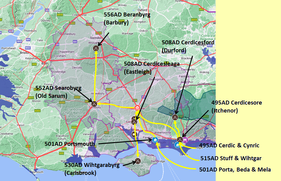
Map generated using Google My Maps 2024 - showing the Landscape, modern Counties and sea in 477AD
Please Note: this map is my interpretation of the Anglo Saxon Chronicles entries relating to Cerdic, Cynric and the West Saxons and their take over of Hampshire, the thin purple line shows the modern Hampshire boundary.
The logic for the coastal changes and the Forest of Andredsweald can be viewed on the following pages:
Roman Roads in Britain
Anglo Saxon Chronicles - 892AD - The Great Oak Forest of Andredsweald
Landscape - Was the high tide level in Saxon times at Pevensey at about 4.5 metres ?
Landscape - Was the high tide level in Saxon times in the Wash 4 to 5 metres higher ?
Landscape - The History of the Romney Marsh in maps
Roman Locations that have not been identified and roads that just terminate
|
|
|
;)


