| Anglo Saxon Chronicles - 534AD - Isle of Wight given to Stuff and Wihtgar |
|---|
| The entry from the Chronicles |
|---|
Original text
Her Cerdic forþferde, ⁊ Cynric his sunu ricsode forþ .xxvi. wintra; ⁊ hie saldon hiera tuæm nefum Stufe ⁊ Wihtgare eall Wiehte ealond.
Translation
534AD. This year died Cerdic, the first king of the West-Saxons. Cynric his son succeeded to the government, and reigned afterwards twenty-six winters. And he gave to their two nephews, Stuff and Wihtgar, the whole of the Isle of Wight.
| Implication |
|---|
It would seem that it took Cerdic and Cynric four years to subdue the island, and its possible Cerdic was killed on the island. After giving the island to Stuff and Wihtgar the island would then be known until the present, as the Isle of Wight (Wihtgar's island) probably originally was Whitsey.
| Possible interpretation of the Chronicles |
|---|
Cerdic & Cynric invaded the Isle of Wight after gaining control of Wessex, probably after taking Winchester. It would seem likely that Wessex was originally made up from the combined Saxon forces who landed nearby, so this would include Cerdic & Cynric, Port, Beda and Mela and of course Stuff and Whtigar all of whom seem to be related, even if Stuff & Whitgar are Jutes according to the ASC.
| Map showing the Battles of Cerdic, Cynric and the West Saxons |
|---|
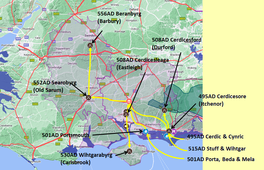
Map generated using Google My Maps 2024 - showing the Landscape, modern Counties and sea in 477AD
Please Note: this map is my interpretation of the Anglo Saxon Chronicles entries relating to Cerdic, Cynric and the West Saxons and their take over of Hampshire, the thin purple line shows the modern Hampshire boundary.
The logic for the coastal changes and the Forest of Andredsweald can be viewed on the following pages:
Roman Roads in Britain
Anglo Saxon Chronicles - 892AD - The Great Oak Forest of Andredsweald
The Variable Ocean: Was the high tide level in Saxon times at Pevensey at about 4.5 metres ?
The Variable Ocean: Was the high tide level in Saxon times in the Wash 4 to 5 metres higher ?
Landscape - The History of the Romney Marsh in maps
The Variable Ocean: Roman Locations that have not been identified and roads that just terminate
|
|
|
;)


