| Battle of Hastings 1066AD - H - Why Hastings? |
|---|
|
The area between Eastbourne and New Romney was vitally important to the Romans, the Vikings, the Saxons and the Normans as it was the area where the Anglo Saxon Chronicles - 892AD - The Great Oak Forest of Andredsweald reached the sea in protected inlets.
| | |
|---|
Introduction ▲ |
|---|
William the Conqueror crossed the Channel in September 1066 with nearly 700 ships, several thousand men, and several hundred horses. He landed at Hastings. The standard explanation is that Hastings was conveniently close to Normandy and offered a defensible beachhead.
That explanation is not wrong. But it is incomplete.
This page argues that William chose Hastings for a reason that goes deeper than geography and closer crossing distance — and that the same reason explains why the Romans built their shore forts here, why the Saxons held this corner of England independently for over three centuries, why the Vikings wintered at Appledore in 893AD, and why the Normans immediately secured both Pevensey and the Hastings burh on the day they landed.
The answer is ships. More precisely, the ability to build them.
The stretch of coast between Eastbourne and New Romney combined everything a medieval shipbuilder needed: high quality Wealden oak close to the coast, abundant iron for nails and fittings, and navigable tidal inlets giving direct access to the sea. For a commander who had already lost approximately 83 vessels in the storm between Dives and St Valérie, and who faced a potentially long campaign far from home, seizing the most productive shipbuilding area on the English south coast was not a bonus. It was a strategic necessity.
It also sent Harold a message he could not ignore — and may have been precisely calculated to do so.
| The Romans ▲ |
|---|
 The Romans occupied the area of East Sussex and West Kent as a military zone, this was due to the rich iron deposits in the area, and the proximity of the oak forest of Andredsweald to the coast and the easy to navigate waterways.
Carausius built the massive shore forts at Portus Lemanis and Anderida at Pevensey to protect the area from the main Roman Empire.
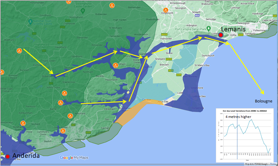
Portus Lemanis was important because the main iron production in the Rother and Brede valleys reached the sea at modern Hythe at the time (Landscape - The History of the Romney Marsh in maps).
Anderida, the fort at Pevensey was built because the main Classis Britannica base at Boulogne was taken in 296AD and it is believed that the Pevensey area especially the area near Ashburnham was a main fleet shipbuilding area, along with the Aspen valley at Hastings. This was due to the availability of high quality oak close to the coast, and the abundance of iron to produce nails for the construction of ships.
| | |
|---|
The Saxons ▲ |
|---|
The Saxons settled the Kingdom of Hastings about 460AD and took over the Roman shipbuilding area in this part of East Sussex. The area was very isolated from other parts of the South East as there were only two main road routes into the area, a ridgeway from the Roman London to Lewes road at Crowborough and the old Roman military road from Gravesend to the main iron works near Sedlescombe.
Hastings retained its independence until King Offa of Mercia took the kingdom in 771AD. For the kingdom to remain independent for 311 years it implies a degree of protection and isolation. The only way this could occur is if the area was fairly wealthy and able to afford a strong military presence.
This wealth could have been provided by sales of ships and timber from Andredweald and possibly iron but this is less likely, however the later Medieval iron production could have destroyed the evidence of Saxon iron production.
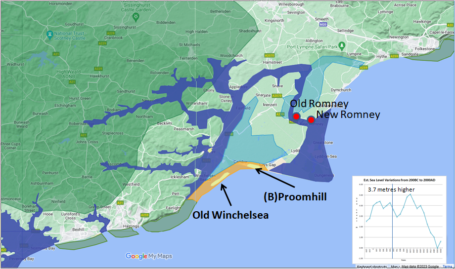
It is very likely that a storm in 566AD rerouted the river Limen(Rother) so that its mouth changed from Hythe which was under control by the Jutes in Kent, to Old Romney which was most likely controlled by the Haestingas.
| | |
|---|
The Vikings ▲ |
|---|
Anglo Saxon Chronicles:
A.D. 893. This year went the large army, that we before spoke about, back from the eastern district westward to Bologne; and there were shipped; so that they transported themselves over at one time with their horses withal. And they came up with two hundred and fifty ships into the mouth of the Limne, which is in East-Kent, at the east end of the vast wood that we call Andred. This wood is in length, east and west, one hundred and twenty miles, or longer, and thirty miles broad. The river that we before spoke about lieth out of the weald. On this river they towed up their ships as far as the weald, four miles from the mouth outwards; and there destroyed a fort within the fen, whereon sat a few churls, and which was hastily wrought.
A.D. 894.When the king heard that, then went he west towards Exeter with all his force, except a very considerable part of the eastern army, who advanced till they came to London; and there being joined by the citizens and the reinforcements that came from the west, they went east to Barnfleet. Hasten was there with his gang, who before were stationed at Milton, and also the main army had come thither, that sat before in the mouth of the Limne at Appledore. Hasten had formerly constructed that work at Barnfleet, and was then gone out on plunder, the main army being at home.
The main Viking army appears to have remained at Appledore (in the area protected from the weather behind the Isle of Oxney) for an extended period of time, perhaps this was to rebuild and make new ships from the Wealden Oak that lay alongside the Rother, as there was not much else around the area at the time except saltmarsh and woodland.
The main Saxon settlement was at Old Romney, with the Langport at New Romney at the time, so the Viking fleet must have passed these villages, and probably killed all or were welcomed by the locals. (Landscape - The History of the Romney Marsh in maps)
| | |
|---|
The Normans ▲ |
|---|
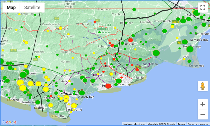 The map above shows the Domesday villages that were destroyed in red, damaged in yellow and not effected in green, the relative sizes show the population of the villages.
Orderic Vitalis provides the first quote of the Norman landing
The Norman expedition, therefore, crossed the sea on the night of the third of the calends of October [29th September], which the Catholic church observes as the feast of St. Michael the archangel, and, meeting with no resistance, and landing safely on the coast of England, took possession of Pevensey and Hastings, the defense of which was entrusted to a chosen body of soldiers, as a base for the Army and shelter for the Fleet.
So the Normans took control of Pevensey Castle and probably the old Burh of Hastings at Baldslow Down and installed trusted troops to defend these strategic forts. They encountered no resistance so its possible the local Saxons invited the Normans into the area.
Master Wace and the Norman landing
The ships steered to one port; all arrived and reached the shore together ; together cast anchor, and ran on dry land ; and together they discharged themselves. They arrived near Hastings, and there each ship ranged by the other's side, and they scoured the whole shore, but found not an armed man there.
The first day they held their course along the sea-shore and on the morrow came to a castle called Penevesel.
So the Normans landed near Hastings, so again probably near Bexhill and the following day took Pevensey castle. They encountered no resistance so this record also implies that the local Saxons invited the Normans into the area.
Carmen de Triumpho Normannico and the landing
The third hour of the day overspread the earth
Since leaving the sea behind when you seize a sheltered strand
The land belonging to you had been stripped of tenants
You rejoice as you and yours seize a peaceful arc of strand
You secure the bridgehead fearing to neglect the ships
And raise palisades, that you may site the camp within
You restore the forts that were long since destroyed
You station garrisons that they may be defended
This report shows that they landed in a protected bay. They restored the Forts, Pevensey and the Hastings Burh, and station troops there to protect them.
All the above report that the Normans took Pevensey and the Fort at Hastings, and landed on the coast possibly in a protected inlet. The major damage to the villages appears to stem from the Bexhill area , with a lot of damaged villages stemming from Pevensey, so probably from foraging by cavalry.
| An Uncontested Landing: The Fécamp Factor ▲ |
|---|
|
Every primary source that describes the Norman landing makes the same observation: they came ashore unopposed. No Saxon force met them on the beach, no militia contested the securing of Pevensey and the Hastings burh, and the fleet landed intact. What followed in the surrounding villages was a different matter — the Domesday damage map shows significant destruction across the Bexhill hinterland in the days after landing, the result of Norman foraging and the systematic stripping of an occupied coast. But the landing itself was uncontested, and that requires explanation beyond Harold's absence in the north.
William did not land on a coast he knew only from maps and sailing directions. The Abbey of Fécamp had been administering the Rameslie estate — encompassing Rye, Old Winchelsea, and the eastern approaches to Hastings — since 1017, nearly fifty years before the Conquest. Norman monks had been collecting fishing tithes, supervising salt production, and administering the churches of the Hastings maritime community for two generations. The men who watched William's fleet come ashore in September 1066 had been paying their obligations to a Norman abbey for most of their lives. The distinction between Norman authority and English authority that appears so stark in the standard narrative of the Conquest was, from the perspective of a Hastings fisherman, not a distinction that had ever been particularly clear.
The political record reinforces this. In 1049 the men of Hastings attacked and destroyed two ships belonging to Swein, Harold's brother, bringing the prizes to Sandwich for the king. This was not a neutral act. It placed Hastings firmly on the side of the Norman-aligned royal line and against the Godwin family at a moment when that distinction mattered enormously. Harold knew which way Hastings faced. It is one reason why, when assembling his fleet on the Isle of Wight in the summer of 1066, he could not fully trust the Hastings contingent in his own navy.
There is a further implication that the timing of William's departure from Dives makes hard to avoid. Harold stood down his fleet on 8 September. Within a day or two, William moved. The proximity has never been satisfactorily explained by wind and weather alone. The Fécamp connection gave Hastings both the motive and the means to carry intelligence across the Channel — fishing vessels made that crossing routinely as part of the normal trade in salted fish and Norman wine. A single Hastings vessel crossing south from the Isle of Wight on the day of the stand-down, rather than east toward Pevensey with the rest of the fleet, would have been invisible in the general dispersal. William may not simply have been watching the weathercock at Saint-Valery. He may have been waiting for a ship.
When that ship came, William knew he was sailing to a coast where the local population would not resist him, where the infrastructure of the Fécamp estate gave him an immediate administrative base, and where the shipbuilding resources of the Andredsweald were available to repair the losses he had suffered in the storm. He did not stumble onto a friendly shore. He sailed to one deliberately.
| | |
|---|
Conclusion ▲ |
|---|
The evidence across four separate civilisations points consistently to the same conclusion: the Hastings area was valuable not primarily as a port, nor as a military stronghold, but as a shipbuilding centre. The combination of high quality Wealden oak close to the coast, abundant iron for nails and fittings, and navigable tidal inlets made this stretch of coast between Eastbourne and New Romney uniquely suited to constructing and maintaining ships.
The Romans built their forts here to protect it. The Saxons settled it and held it independently for over three centuries. The Vikings wintered at Appledore specifically to exploit it. The Normans landed here and immediately secured both Pevensey and the Hastings burh.
William's decision to land at Hastings rather than on the open farmland of Kent — where his cavalry would have had far more room to operate — only makes sense in this context. He was not simply seeking a fight with Harold. He was seizing the most strategically valuable asset on the English south coast.
This matters more than it might first appear. As established on Page Battle of Hastings 1066AD - D - Sailing - Dives sur Mer to St Valerie, William had already lost approximately 83 ships — predominantly supply and transport vessels — in the storm before he even left Normandy. He crossed the Channel with a depleted and battle-damaged fleet. Securing a working shipyard was not an optional prize. It was a strategic necessity. Without the ability to repair his fleet and resupply by sea, William's position in England would have been precarious regardless of what happened on the battlefield.
Seizing the Hastings shipyards also sent Harold an unmistakable message. Harold knew better than anyone what those yards were worth — his own naval power depended on them. Threatening to burn or permanently occupy the most productive shipbuilding area in southern England was almost certainly calculated to force Harold to respond quickly, before he was ready, rather than consolidating his forces after the exhausting march back from Stamford Bridge.
William did not stumble into the Hastings peninsula by chance or convenience. He came here because this was where England built its ships — and he needed those ships as much as he needed to win the battle.
|
|
|
|
;)


