|
 | Anglo Saxon History |  | |
| | Landscape - The Legend of Tenterden Church and the Goodwin Sands |
|---|
| |
|---|
| The Legend |
|---|
The building of the steeple of Tenterden's St Mildreds church was the cause of the Goodwin Sands.
| | |
|---|
| The Source of the Legend |
|---|
The legend appears to have first been recorded in a book from 1659 by Richard Kilburne of Hawkherst, and was printed by Thomas Mabb for Henry Atkinson, and are to be sold at his shop.
The title of the book is:
A topographie or survey of the county of Kent with some chronological, historicall, and other matters touching the same, and the several parishes and places therein
There is an online version of this text as at 8th June 2024 at 'The University of Mitchigan Library' please click here
| | |
|---|
The Legend
|
|---|

| | |
|---|
| The Relevent text from the Book |
|---|
'(Goodwin Earl of this County, and father of King Harold) was in the time of King Edward the Confessor owner of a great quantity of flat Lands in this County (neer
description Page 263 the Isle of Thane) defended from the sea by a great wall, which lands afterwards (in the year 1099.) was parcell of the possessions of the Abbot of St. Augustine (but reteyned the name of Goodwin, formerly owner thereof) and that Abbot, being then also owner of the Rectory of Tenterden, and having begun the building of this steeple and the time of year for such purpose being much spent, the thoughts, and actions, of him, and his agents were so set upon the finishing of that work, that they neglected the care of watching, and preserving the aforesaid wall, and (3. of November in that year) the sea broke over, and ruined the same, and drowned the aforesaid lands (over∣whelming the same) with a light sand, (there still remaining) and the place thereby obteyned the name of Goodwin Sands, and became (as still it is) dreadfull, and dangerous to Navigators, and thus (accidentially) this Tenterden steeple is said to be the cause of Goodwin sands.'
| | |
|---|
| The founding of Tenterden |
|---|
The settlements with the snippet suffix 'den' in their name derive from den-bera - a forest swine pasture, most were settled after Domesday, by people from Kent.
Tenterden is one of those villages not recorded in Domesday so was settled later than 1086AD and was probably settled by displaced Saxons from Kent who were trying to escape the Norman persecution.
The Tenter snippet is probably derived from Tenetwara meaning 'the people of Thanet, however there is another possibility that it derives from tender - tinder for fire lighting because the town was settled in The Great Forest of Andredsweald - Anglo Saxon Chronicles
| | The Eclesiastical details |
|---|
There are a considerable number of settlements in the Forest area where the stone churches were started in the 12th century, Tenterden being one of these with its religious health being supported by the Abbot of St. Augustine(Thanet).
Abbots of St Augustines from Wikipedia:
Wido (1087–1099) - he was probably a Saxon with the Normans taking over after Wido
Hugh I of Fleury (d. 26 March 1124), a Norman
Hugh II of Trottiscliffe (1125 – 25 June 1151), a monk of Rochester, election confirmed by cardinal-legate John of Crema
Sylvester (1152–1161), prior, went to Rome to have his election confirmed by the pope, was later excommunicated and deposed by the archbishop, but restored before his death
Clarembald (1163–1173/76), a layman appointed by the king, deposed
Roger (1176 – 20 October 1212), went to Tusculum to be consecrated by the pope
Alexander le Pargiter (1212 – 4 October 1220), went to Rome to be consecrated by the pope
The reference to 1099AD in the original text appears to refer to the transition between the Saxon Abbot 'Wido' and a Norman Abbot 'Hugh I of Fleury'.
The first recorded rector(better paid vicar) of St Mildreds in Tenterden was Hugo Norman from 1180AD until 1240AD, the north arcade of the chancel was probably built in the 1100's so it is likely Hugo was responsible for overviewing the stone construction.
| | The fire at St Augustine |
|---|
From Wikipedia
There was further rebuilding as a result of the great fire in 1168. The fire's destruction accounts for the paucity of historical records for the preceding period.
Although the fire was at St Augustine's in Canterbury, it was probably the records center for all the Kent monasteries, and hence any records of an island were lost in 1168AD.
| | The Abbot of St Augustine |
|---|
English Heritage quotes:
'In 597 St Augustine landed on the shores of the Anglo-Saxon kingdom of Kent at Thanet. He was on a mission from Pope Gregory the Great to convert the pagan Anglo-Saxons to Christianity. Christianity had first been introduced to Britain by the Romans, but survived only in the west after the invasions of pagan peoples from northern Europe in the 5th century.'
'Its prestige was also enhanced by the translation (moving) of the relics of the 8th-century St Mildred from Minster-in-Thanet to St Augustine’s. Mildred was the great-great-granddaughter of King Æthelberht, and the translation affirmed the historical importance of the abbey and its connections with Kentish royalty.'
| | The Goodwin Sands |
|---|
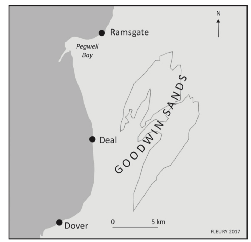
The Goodwin sands are an area to the east of Kent that are close to high tide level and are in the majority a sandy area that has caused numerous ships to be lost when they have run aground.
It is possible that Earl Godwin controlled this island off the Kent coast prior to 1066AD, the ownership of which was transferred to St Augustine's Monastery (Thanet) when the Abbey control was moved from Saxon to Norman in 1099AD and the monastery gained additional lands in Kent.
| 
| | |
|---|
| The Geographica of Claudius Ptolemy |
|---|
The first known map of the world was produced by Claudius Ptolemy in about 150AD and has references to islands off the East Coast.
Londinium (London) 20°00.54°00
Tamesa estuary (Thames Estuary) 20°30.54°30 (the Thames estuary)
Next to this the Cantium promontory (Kent Promontory) 22°00.54°00 (probably
Eastward from the Trinovantes region there are two islands: ( which appear to be in the North Sea)
Toliapis (Unknown) 23°00.54°20
Counus (Unknown) island 24°00.54°30
Daruernum (probably Rochester - Durobrivae) 21°00.54°00
Rutupiae (probably Richborough) 21°45.54°00
Unfortunately we are unable to plot these locations as the accuracy of Ptolemy's locations, or more likely our interpretation of their locations does not give us enough clues.
These records probably refer to islands off the coast of Essex, but I have included them as I can't be sure.
| | Possible Serious Weather Events around this period |
|---|
The following weather reports are from Weather Web
973
'Thames flood in London.'
29th September 1014
'"St. Michael's day Flood"; Possible major flood due storm-surge (or some have "tsunami") occurred on 'St. Michael's Day, which is September 29th (OS) in the western / Christian calendar. (Note that Dutch chronicles have this as September 28th). Great damage to coastal communities along the English south coast & given the impact on the eastern side of the southern North Sea, surely had a significant effe't on the English side of that water
11th November 1099
'A tidal flood affected the R. Thames estuary & adjacent areas of north Kent; it is not known whether London was affected, but according to legend, this inundation was responsible for the formation of the Goodwin Sands. The flooding also affected the Dutch coastal areas, so 'tidal' is problematic: I would suspect a wind-driven storm-surge which coincided with a high tide (?spring / exceptional?), and possible excessive autumnal land-water. "Thousands" of deaths reported in areas affected. (I would have thought that if London had been seriously affected, some chronicle of it would have survived?: The 11th century saw a high number of disastrous floods along the English east coast.)'
10th August 1103
'"Great storm on St. Lawrence's Day which did much harm." I believe this Day is celebrated in the Catholic church (and therefore generally at this time) on the 10th August (OS). One site says the storm occurred on the morning of this day - and did more damage than anyone could remember.'
| | |
|---|
| Tenterden Church Tower |
|---|
From the Tenterden website
'This, the most interesting building in Tenterden is dedicated to St Mildred and has a lofty tower that can be seen for many miles across the Kentish Weald. The dedication is not a very common one. St Mildred was a very pious and revered lady who became Abbess of the Abbey at Minster in Kent. Buried originally in her beloved abbey her relics were later transferred to a shrine at Canterbury Cathedral.'
From Wikipedia
St. Mildred's Church is an Anglican church located in Tenterden in the borough of Ashford in Kent, England.
'The church dates from about the 12th century and is Grade I heritage listed.[1] The main tower of the church is 39.6 metres (130 feet) high and was constructed in 1461. It is dedicated to a prominent Anglo-Saxon saint, Saint Mildred—a 7th-century princess who served as the abbess of the nunnery at Minister-in-Thanet. '
The church tower was not started until the height of Tenterden's influence in the Cinque Ports.
| | |
|---|
| Is there any truth in this Legend |
|---|
The cost of constructing the first stone part of St Mildred's Chancel in the 1100's taking funding from the sea defenses on the island might explain the basis of this legend.
However if an island existed and was lost it would have had to be pre 1168AD and probably post 1099AD, however the storm on 11th November 1099 could possibly be responsible for its demise. If an island existed in early medieval times, you would expect some reference to this in some documentation, however the fire at St Augustine's in Canterbury which destroyed the local records could explain this.
However the building of the the tower of the church was started in 1461AD at the height of Tenterden’s prosperity and by this time an island off the coast of Kent would have been recorded in the Cinque Ports annals at least, so this part of the Legend cannot be true.
Its a nice legend and some of it may be true but there is no way today to prove it either way.
|
|
|
|
|
| |
|
|
Local Interest
Just click an image |
|
|
|
|
|
|
|
|
|
|
|
|
| |
|
|