|
Landscape - The Cliffs of East Sussex and Erosion 450-2024AD |
|---|
The Sussex cliffs include the sandstone outcrops near to Hastings and the Chalk Cliffs that go from Eastbourne past Brighton, including Beachy Head and the Seven Sisters .
|
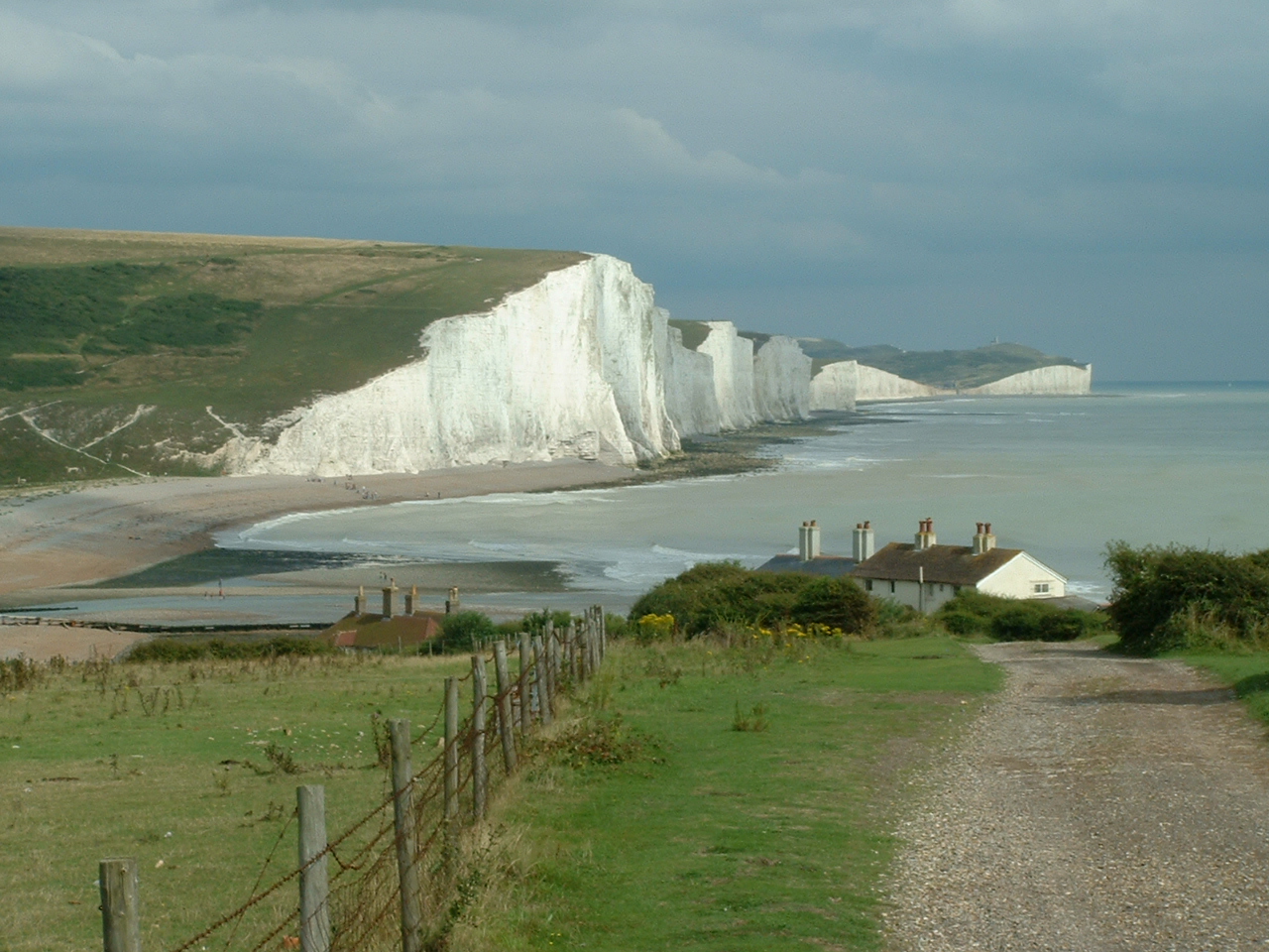
The Seven Sisters taken in July 2005
|
| |
|---|
Background |
|---|
The reason for this article is that I was interested in the coastline of Roman Britain and when Aelle the Saxon landed in Sussex in 477AD, however this erosion also effects a lot of other of my historic interests.
|
| |
|---|
Geology of the Region |
|---|
The cliffs from Brighton to Beachy Head are made up of Sussex White Chalk which is mostly chalk with very few large fossils. From Beachy Head to Eastbourne the cliffs are mostly made up of Lower Chalk formations, these contain more clay and fossils than the purer Sussex White Chalk. The Pevensey Marshes then separate these Chalk Cliffs from the Sandstone and clay cliffs from Hastings through Fairlight to Pett .
The cliffs from Brighton to Newhaven contain the highest human population density and most of the modern sea defenses can be found here against these cliffs.
The Chalk cliffs at Seaford
These are being eroded at a slower rate than those at the Birling Gap at about 0.3 metres per year. The Romans had a large settlement on top of this part of the Downs, probably with their main port at the mouth of the Ouse valley near modern Seaford. However at the time this headland would still have been a further 500 metres out in the English Channel.
From the Ouse past Seaford to the Cuckmere valley the cliffs are not really visible as the coastline curves out into the sea. This area is eroding quite quickly up to 0.6 metres per year. The Cuckmere valley was probably even more sheltered in Roman and Saxon times due to the Seaford headland and the Seven Sisters being further out to sea .
The Seven Sisters
These are actually the valleys along the Chalk Cliffs from the Cuckmere Valley towards Beachy Head . The erosion at this point is quite rapid at about 0.6 metres per year so the headland would have been much further out to sea.
At the Birling Gap on the hill toward the Belle Tout lighthouse is the remains of an ancient defensive works, of which more than half has been washed away.
Birling Gap to Beachy Head
This is a foreland so is only really visible from the sea, the land is still eroding at the 0.6 metres per year rate. The Belle Tout lighthouse has been moved back 50 metres from the cliff edge in 1999, and is now in need of movement further inland.
Beachy Head
This is the headland between the Seven Sisters and Eastbourne , here the cliffs stand nearly vertically 162 metres above Sea Level making them the tallest Chalk Cliffs in Britain. The views across this area on a sunny summers afternoon are absolutely stunning.
The erosion here is probably about 0.5 metres per year so is still quite fast in geological terms.
Pevensey Levels and Bexhill
This area is mostly flat farmland with a few small hills at Bexhill.
Filsham Valley
At the east end of Bexhill is a small cliff at Galley Hill which would have protected the entrance to the Filsham valley(old Hastings Harbour).
St Leonards to Pett Level
The area along St Leonards seafront is the start of the Sandstone cliffs that go all the way to Pett Level, with a few valleys such as Hastings Old Town.
The land between Fairlight and Cliff's end at Pett Level is made up of bands of clay and sandstone so the erosion can be very quick if the bands of clay are at high tide level. The cliffs along this area are not a steep as the Chalk Cliffs to the west, but still stand quite high.
The erosion here is probably about 0.5 metres per year so is still quite fast in geological terms.
|
| |
|---|
Erosion |
|---|
It is believed that the cliffs along this stretch of coastline have been eroding fairly constantly over time, with the following observations made for the different areas based on the differences between the Ordnance Survey maps from 1873 to the present day.
Peacehaven appears to have been eroding at about 0.3 metres per year.
Birling Gap appears to have been eroding at about 0.6 metres per year
Ecclesbourne Glen(Hastings) 0.3 metres per year
Fairlight Cove 0.6 metres per year
Extrapolating the above would mean that the cliffs at Fairlight could have been a further 550 metres out in 1066 and in Saxon times about 900 metres towards France. The Chalk Cliffs at the Seven Sisters would have been the same at 550 metres further in 1066 and 900 metres in Saxon times.
|
 The green areas shown on the coast are the estimated area of additional land that time has eroded since 1066AD.
The orange areas are shingle banks that are made up of spoil from the cliffs, Old Winchelsea and Broomhill are shown in yellow.
|
| |
|---|
Erosion Rates by location |
|---|
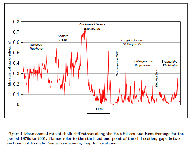
Click the image to see the original article
|
| |
|---|
Deposition of eroded material |
|---|
The East Sussex coastal area has longshore drift that transports cliff fall spoil towards the East hence creating shingle banks to the eastern edges of the cliffs at Eastbourne and Fairlight.
The deposited chalk from the cliffs between Brighton and Eastbourne only provides a few flint nodules and some gravels, this is because the chalk that falls is slowly dissolved in the salt water making it more acidic, but not providing much spoil. Hence a shingle bank produced by the cliffs at Beachy Head is not as large as others further to the East.
The cliffs at Hastings and Fairlight however contain large amounts of sandstone which is not soluble in the sea, hence the shingle produced is significantly more than that produced by chalk cliffs. These cliffs also have horizontal bands of clay that the sea can easily erode, and therefore the average erosion rate is significantly faster than other sandstone cliffs that don't have the clay layers.
It's the shingle from these cliffs that have created modern Pett Level, and the spit at Dungeness, and have influenced the outfall of the river Rother, which has moved from Hythe in Roman times to New Romney and finally to Rye today, a distance of about 20 miles, due in the most part to the longshore drift and a few very fierce storms that hit this part of the country.
Landscape - The 1287AD Storm and its effect on the Kent and Sussex Coast
Click the following link to see the changes in the Romney Marsh over time.
(Landscape - The History of the Romney Marsh in maps)
|
| |
|---|
References |
|---|
University of Sussex research
Retreat of Chalk cliffs in the eastern English Channel during the last century
Landslip Remediation of Fairlight Cove, Brighton Cliff
Geological Investigation of the Ashdown Beds at Fairlight
Archaeology, Art & Coastal Heritage - Hastings case study
|
;)


